
British Columbia provincial highway 99
Encyclopedia
Highway 99, also known as the Sea to Sky Highway, the Squamish Highway, Route 99, or Whistler Highway, is the major north-south artery running through the Greater Vancouver
area of British Columbia
from the U.S. border, up Howe Sound
through the Sea to Sky Country to Lillooet
, and connecting to Highway 97 just north of Cache Creek
. The number of this highway is derived from the old U.S. Route 99
, with which the highway originally connected. The highway currently connects with Interstate 5
at the international border.
This highway received the '99' designation in 1942 upon completion of the King George Highway, and it originally shared an alignment with Highway 1 from Surrey
to Vancouver
. The current freeway alignment of Highway 99 between 8th Avenue in South Surrey
and the North Arm of the Fraser River
opened in 1962. Between 1964 and 1973, the freeway alignment of Highway 99 was designated Highway 499.
In 1957, the northern end of Highway 99 was moved from downtown Vancouver, across the Lions Gate Bridge and west to the village of Horseshoe Bay, following Marine Drive through West Vancouver. Highway 99 was re-aligned via Taylor Way, just east of the Park Royal Shopping Centre
, to the Upper Levels Highway and extended to Britannia Beach
one year later, extending to Squamish
in 1959, and to Pemberton
in 1966. Finally, in 1992, the just-paved Duffey Lake Road between Pemberton
and Lillooet
was made part of Highway 99, and the section of Highway 12 between Lillooet and Highway 97 was re-numbered 99. The portion of the highway between Lillooet and Pavilion
was part of the route of the Old Cariboo Road
.
The total length of Highway 99 from the U.S. border to the Highway 97 junction is 409 kilometres (254.1 mi). In 2006 the UK's The Guardian
newspaper listed the Sea to Sky as the 5th best road trip.
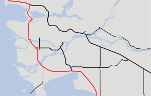
 In the south, Highway 99 begins at the British Columbia – Washington State border crossing at Douglas
, on the Canadian side of Peace Arch Park
, as a continuation of Interstate 5
. The highway begins with a four-lane freeway configuration. Highway 99 travels through Surrey
12 kilometres (7.5 mi) due northwest from the border, through four interchanges, and then turns west for 4 kilometres (2.5 mi) before reaching the junction with Highway 91, marking the highway's entry into the Corporation of Delta
. Four km (2½ mi) west, Highway 99 reaches its junction with Ladner Trunk Road (formerly Highway 10). Eight km (5 mi) north, Highway 99 reaches a junction with Highway 17. Another 2 kilometres (1.2 mi) northwest, Highway 99 crosses into Richmond
through the George Massey Tunnel
, also known as the Deas Tunnel or Deas Island Tunnel.
Through Richmond, Highway 99 travels 7 kilometres (4.3 mi) north from the Steveston Highway interchange, at the north mouth of the tunnel, to a junction which connects to the Westminster Highway, Knight Street, and western end of Highway 91. Another 4 kilometres (2.5 mi) northwest, the southern freeway section of Highway 99 ends as the highway crosses the North Arm of the Fraser River, over the Oak Street Bridge
, into Vancouver.
.jpg) The 30 kilometres (18.6 mi) long route through Vancouver's city streets starts off going north on Oak Street
The 30 kilometres (18.6 mi) long route through Vancouver's city streets starts off going north on Oak Street
to the intersection with West 70th Avenue. Highway 99 then goes west on West 70th Avenue, and then north along Granville Street
for 7 kilometres (4.3 mi). It crosses over False Creek
(via the Granville Street Bridge
) into the downtown core. Highway 99 north goes through the downtown area by way of Seymour Street (southbound it uses Howe Street) and Georgia Street
, through Stanley Park
, and over the Lions Gate Bridge into West Vancouver at Marine Drive.
with Highway 1 for 12 kilometres (7.5 mi) west, diverging from Highway 1 near the BC Ferries
terminal at Horseshoe Bay.
 The "Sea to Sky Highway" is the name given to the section of Highway 99 from Horseshoe Bay to Pemberton
. From Horseshoe Bay, the highway travels along the coast of Howe Sound
for 12 kilometres (7.5 mi) to Lions Bay, north for another 21 kilometres (13 mi) to Britannia Beach
, and north for 11 kilometres (6.8 mi) to Squamish
, at the head of Howe Sound. From Squamish, it continues north for another 58 kilometres (36 mi) to Whistler
, and then to Pemberton
32 kilometres (19.9 mi) later, where the Sea-to-Sky Highway ends and Duffey Lake Road begins. After going ninety-nine kilometres (62 mi) northeast, Highway 99 reaches the junction with Highway 12 at Lillooet
, and then goes northeast for another 75 kilometres (46.6 mi) to its northern terminus at its junction with Highway 97, just north of Cache Creek
.
The Sea to Sky Highway section of Highway 99 has a checkered history. Built on a steep cliff overlooking Howe Sound, it was a two-lane undivided highway with no outside barrier. Many motorists have lost their lives on it due to inclement weather, poor visibility, speeding, passing slower vehicles, or drunk driving. (Local media have called it variously the "Killer Highway", the "Highway of Death", and the "Ski-And-Die Highway".)
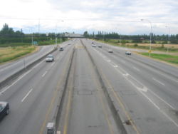
As part of the 2010 Winter Olympics
bid, the British Columbia provincial government has authorized upgrading the highway to accommodate greater traffic loads, widening the highway and adding a concrete divider. Starting in 2002 a large section was upgraded between Squamish and Whistler that had already seen major improvements during the 1980s. The Sea to Sky is a freeway from the interchange with Highway 1 to the at-grade intersection with Lawrence Way. After that, there are sporadic interchanges and at-grade intersections. It is mostly a divided highway all the way to Lions Bay and through Squamish.
On-site protests delayed part of the construction. Protesters claimed that a tunnel under Eagleridge Bluffs was a safer and environmentally friendlier alternative. A court injunction and police were used to remove the protestors, one of whom, Harriet Nahanee
, a respected Sḵwx̱wú7mesh elder, died soon after in the Surrey Pre-Trial Centre from health complications alleged to be related to her arrest and incarceration.
!Regional district
!Location
!km
!Exit
!Destinations
!Notes
|-
|align=center colspan=6|Continues as Interstate 5
towards Seattle
|-
|rowspan=52|Metro Vancouver
|rowspan=6|City of Surrey
|
|
|Peace Park Drive
|Northbound entrance only
|-
|
|
|Beach Road
|At-grade intersection
|-
|
|2
|8th Avenue/King George Highway
|Signed as exits 2A and 2B southbound, to Truck Border Crossing
|-
|
|8A
|152nd Street southbound
|Southbound exit only
|-
|
|8B
|32nd Avenue Diversion
|Southbound exit, Northbound entrance only
|-
|
|10
|King George Highway
|No access to Highway 99 southbound from King George northbound
|-
|rowspan=5|Corporation of Delta
|
|16
|Highway 91 (Annacis Highway) to Richmond, New Westminster
|
|-
|
|20
|Ladner Trunk Road
|
|-
|bgcolor=#ffdead|
|bgcolor=#ffdead|
|bgcolor=#ffdead|South Fraser Perimeter Road
|bgcolor=#ffdead|Interchange under construction
|-
|
|28
|Highway 17 to Ladner
, Tsawwassen, Ferries
|
|-
|
|29
|River Road
|Southbound exit only
|-
|align=center colspan=5|George Massey Tunnel
under the South Arm Fraser River
|-
|rowspan=8|City of Richmond
|
|
|Rice Mills Road
|Southbound exit accessible only via scale
|-
|
|32
|Steveston Highway
|
|-
|
|36
|Westminster Highway
|Northbound exit and southbound entrance only
|-
|
|37
|Highway 91 (Richmond Freeway) to Richmond, New Westminster
|
|-
|
|38
|Shell Road
|Southbound exit and northbound entrance only
|-
|
|39B
|No. 4 Road southbound
|Southbound exit only
|-
|
|39
|Bridgeport Road
|Vancouver International Airport
, northbound exit only
|-
|
|39A
|Sea Island Way
|Vancouver International Airport, souhthbound exit only
|-
|align=center colspan=5|Oak Street Bridge
over the North Arm Fraser River
|-
|rowspan=10|City of Vancouver
|
|41
|Marine Drive, Oak Street southbound
|Signed 41A/41B northbound, unsigned southbound
|-
|align=center colspan=4|Continues as Oak Street
, 70th Avenue and Granville Street
into Vancouver
|-
|
|
|4th Avenue
|SB only, heads east
|-
|
|
|4th Avenue/Fir Street
|Southbound exit only, heads west for 4th Ave, NB entrance
|-
|align=center colspan=4|Granville Street Bridge
over False Creek
|-
|
|
|Seymour Street
|Hwy 99 northbound exits to Seymour, 99 southbound enters from Howe
|-
|align=center colspan=4|Continues as Howe Street, Seymour Street
|-
|
|
|Georgia Street
|At-grade intersection, Hwy 99 turns onto Georgia
|-
|align=center colspan=4|Continues as Georgia Street
|-
|
|
|Stanley Park Drive
|Closed during peak hours
|-
|align=center colspan=5|Lions Gate Bridge over Burrard Inlet
|-
|rowspan=14|District of West Vancouver
|
|
|Marine Drive
|Hwy 99 exits onto Marine Drive, right turns onto Taylor Way
|-
|
|
|Park Royal Shopping Centre
|SB exit and NB entrance only
|-
|align=center colspan=4|Continues as Taylor Way
|-
|bgcolor=#ddffdd|
|bgcolor=#ddffdd|
|bgcolor=#ddffdd|Taylor Way
|bgcolor=#ddffdd|Enters Highway 1
|-
|
|11
|15th Street, Cross Creek Road
|
|-
|
|10
|21st Street, Skilift Road, Orchard Way
|NB exit and SB entrance and exit only
|-
|
|8
|Cypress Bowl Road
|
|-
|
|7
|Wentworth Avenue, Westmount Road
|
|-
|
|4
|Westport Road, Northwood Drive
|
|-
|bgcolor=#ddffdd|
|bgcolor=#ddffdd|3
|bgcolor=#ddffdd|Highway 1 (Upper Levels Highway) to Horseshoe Bay Drive (Former Highway 99) & Nanaimo via ferries
|bgcolor=#ddffdd|Exits Highway 1
|-
|
|2
|Eagleridge Drive
|
|-
|
|
|Horseshoe Bay Drive (Former Highway 99) to Horseshoe Bay
|Southbound exit and northbound entrance only, to Horseshoe Bay
|-
|
|
|Ansell Place
|
|-
|
|
|Lawrence Way
|At-grade intersection
|-
|
|
|
|Strachan Point Road
|Right-in, right out
|-
|
|
|
|Ocean Point Drive
|At-grade intersection
|-
|rowspan=4|Village of Lions Bay
|
|
|Kelvin Grove Way
|
|-
|
|
|Lions Bay Avenue
|
|-
|
|
|Cristal Falls Road
|
|-
|
|
|Brunswick Beach Road
|At-grade intersection
|-
|rowspan=39|Squamish-Lillooet Regional District
|
|
|
|Porteau Cove Provincial Park
|At-grade intersection
|-
|
|
|
|Furry Creek Drive
|NB Right-in, right-out
|-
|
|
|
|Sea View Drive
|SB Right-in, right-out
|-
|rowspan=2|Community of Britannia Beach
|
|
|Britannia Beach Road
|At-grade intersection
|-
|
|
|Main Street
|At-grade intersection
|-
|
|
|
|Murrin Provincial Park
|
|-
|
|
|
|Darrel Bay Road to Shannon Falls Provincial Park
|At-grade intersection
|-
|
|
|
|Stawamus Chief Provincial Park
|
|-
|
|
|
|Stawamus Chief (parking, rest area)
|
|-
|rowspan=11|District Municipality of Squamish
|
|
|Valley Drive, Stawamus Road
|At-grade intersection
|-
|
|
|Guildford Drive
|At-grade intersection
|-
|
|
|Scott Crescent
|SB Right-in, right-out
|-
|
|
|Cleveland Avenue to Downtown Squamish
, Loggers Lane
|At-grade intersection
|-
|
|
|Industrial Way, Finch Drive
|At-grade intersection
|-
|
|
|Pioneer Way
|At-grade intersection
|-
|
|
|Centennial Way
|
|-
|
|
|Mamquam Road
|At-grade intersection
|-
|
|
|Garibaldi Way
|At-grade intersection
|-
|
|
|Depot Road
|At-grade intersection
|-
|
|
|Squamish Valley Road, Alice Lake Road to Alice Lake Provincial Park
|At-grade intersection
|-
|
|
|
|Brohm Lake Recreational Site
|
|-
|
|
|
|Black Tusk Access Road to Garibaldi Lake
|At-grade intersection
|-
|
|
|
|To Black Tusk Drive, Black Tusk Village
|
|-
|
|
|
|Brandywine Falls Provincial Park
|
|-
|
|
|
|Callaghan Valley Road
|At-grade intersection
|-
|rowspan=14|Resort Municipality of Whistler
|
|
|Cheakamus Valley Road
|At-grade intersection
|-
|
|
|Spring Creek Drive
|At-grade intersection
|-
|
|
|Taylor Way
|SB Right-in, Right-out
|-
|
|
|Lake Placid Road/London Lane to Creekside
|At-grade intersection
|-
|
|
|London Lane
|At-grade intersection
|-
|
|
|Whistler Way
|NB Right-in, right-out
|-
|
|
|Village Gate Road to Whistler
Village
|At-grade intersection
|-
|
|
|Whistler Cay Drive
|At-grade intersection
|-
|
|
|Lormier Road
|At-grade intersection
|-
|
|
|Nancy Greene Drive
|At-grade intersection
|-
|
|
|Blackcomb Way
|At-grade intersection
|-
|
|
|Alpine Way
|At-grade intersection
|-
|
|
|Emerald Drive, Summer Lane
|At-grade intersection
|-
|
|
|To Whistler Heliport
|
|-
|align=center colspan=6|Continues as Sea to Sky Highway to Pemberton and Lillooet
|-
|align=center colspan=6|Ends at Highway 97 north of Cache Creek
Greater Vancouver
Greater Vancouver is the metropolitan area centred on the city of Vancouver, British Columbia, Canada, roughly coterminous with the Greater Vancouver Regional District, which is governed by a body known as Metro Vancouver...
area of British Columbia
British Columbia
British Columbia is the westernmost of Canada's provinces and is known for its natural beauty, as reflected in its Latin motto, Splendor sine occasu . Its name was chosen by Queen Victoria in 1858...
from the U.S. border, up Howe Sound
Howe Sound
Howe Sound is a roughly triangular sound, actually a network of fjords situated immediately northwest of Vancouver.-Geography:Howe Sound's mouth at the Strait of Georgia is situated between West Vancouver and the Sunshine Coast. The sound is triangular shaped, open on its southeast towards the...
through the Sea to Sky Country to Lillooet
Lillooet, British Columbia
Lillooet is a community on the Fraser River in western Canada, about up the British Columbia Railway line from Vancouver. Situated at an intersection of deep gorges in the lee of the Coast Mountains, it has a dry climate- of precipitation is recorded annually at the town's weather station,...
, and connecting to Highway 97 just north of Cache Creek
Cache Creek, British Columbia
Cache Creek is a junction community northeast of Vancouver in British Columbia, Canada. It is on the Trans-Canada Highway in the province of British Columbia at its junction with northbound Highway 97...
. The number of this highway is derived from the old U.S. Route 99
U.S. Route 99
U.S. Route 99 was the main north–south highway on the West Coast of the United States until 1964, running from Calexico, California, on the U.S.-Mexico border to Blaine, Washington, on the U.S.-Canada border. It was a route of the United States Numbered Highways, assigned in 1926 and existing...
, with which the highway originally connected. The highway currently connects with Interstate 5
Interstate 5
Interstate 5 is the main Interstate Highway on the West Coast of the United States, running largely parallel to the Pacific Ocean coastline from Canada to Mexico . It serves some of the largest cities on the U.S...
at the international border.
This highway received the '99' designation in 1942 upon completion of the King George Highway, and it originally shared an alignment with Highway 1 from Surrey
Surrey, British Columbia
Surrey is a city in the province of British Columbia, Canada. It is a member municipality of Metro Vancouver, the governing body of the Greater Vancouver Regional District...
to Vancouver
Vancouver
Vancouver is a coastal seaport city on the mainland of British Columbia, Canada. It is the hub of Greater Vancouver, which, with over 2.3 million residents, is the third most populous metropolitan area in the country,...
. The current freeway alignment of Highway 99 between 8th Avenue in South Surrey
Surrey, British Columbia
Surrey is a city in the province of British Columbia, Canada. It is a member municipality of Metro Vancouver, the governing body of the Greater Vancouver Regional District...
and the North Arm of the Fraser River
Fraser River
The Fraser River is the longest river within British Columbia, Canada, rising at Fraser Pass near Mount Robson in the Rocky Mountains and flowing for , into the Strait of Georgia at the city of Vancouver. It is the tenth longest river in Canada...
opened in 1962. Between 1964 and 1973, the freeway alignment of Highway 99 was designated Highway 499.
In 1957, the northern end of Highway 99 was moved from downtown Vancouver, across the Lions Gate Bridge and west to the village of Horseshoe Bay, following Marine Drive through West Vancouver. Highway 99 was re-aligned via Taylor Way, just east of the Park Royal Shopping Centre
Park Royal Shopping Centre
Park Royal Shopping Centre, opened in 1950, is a shopping mall located in West Vancouver, British Columbia, Canada. Park Royal is officially Canada's first covered shopping mall. Park Royal currently markets itself as five star shopping and has undergone significant changes to attain this...
, to the Upper Levels Highway and extended to Britannia Beach
Britannia Beach, British Columbia
Britannia Beach is a small unincorporated community in the Squamish-Lillooet Regional District located approximately 30 kilometers north of Vancouver, British Columbia on the Sea-to-Sky Highway on Howe Sound. It has a population of about 300....
one year later, extending to Squamish
Squamish, British Columbia
Squamish is a community and a district municipality in the Canadian province of British Columbia, located at the north end of Howe Sound on the Sea to Sky Highway...
in 1959, and to Pemberton
Pemberton, British Columbia
Pemberton is a village north of Whistler in the Pemberton Valley of British Columbia in Canada, with a population of 2,192. Until the 1960s the village could be accessed only by train but that changed when Highway 99 was built through Whistler and Pemberton.-Climate:The climate of Pemberton is...
in 1966. Finally, in 1992, the just-paved Duffey Lake Road between Pemberton
Pemberton, British Columbia
Pemberton is a village north of Whistler in the Pemberton Valley of British Columbia in Canada, with a population of 2,192. Until the 1960s the village could be accessed only by train but that changed when Highway 99 was built through Whistler and Pemberton.-Climate:The climate of Pemberton is...
and Lillooet
Lillooet, British Columbia
Lillooet is a community on the Fraser River in western Canada, about up the British Columbia Railway line from Vancouver. Situated at an intersection of deep gorges in the lee of the Coast Mountains, it has a dry climate- of precipitation is recorded annually at the town's weather station,...
was made part of Highway 99, and the section of Highway 12 between Lillooet and Highway 97 was re-numbered 99. The portion of the highway between Lillooet and Pavilion
Pavilion, British Columbia
Pavilion is a ranching and Indian Reserve community in the Fraser Canyon area of British Columbia, Canada. Most of the community is the population of the Pavilion 1 Indian Reserve of the Pavilion Indian Band, aka the Ts'kw'aylaxw First Nation but there are also a number of ranches in the...
was part of the route of the Old Cariboo Road
Old Cariboo Road
The Old Cariboo Road is a reference to the original wagon road to the Cariboo gold fields in what is now the Canadian province of British Columbia...
.
The total length of Highway 99 from the U.S. border to the Highway 97 junction is 409 kilometres (254.1 mi). In 2006 the UK's The Guardian
The Guardian
The Guardian, formerly known as The Manchester Guardian , is a British national daily newspaper in the Berliner format...
newspaper listed the Sea to Sky as the 5th best road trip.
South Surrey to Richmond
Douglas, British Columbia
Douglas is a locality in Surrey, British Columbia, Canada, just southeast and outside of the boundary of White Rock, that is the Canadian side of the Peace Arch Border Crossing between British Columbia and Whatcom County, Washington in the United States...
, on the Canadian side of Peace Arch Park
Peace Arch Park
Peace Arch Park is a park straddling the International Boundary between the United States and Canada at the extreme western end of the main contiguous section of the two countries' land border, where it reaches Semiahmoo Bay of Puget Sound on the continent's Pacific Coast...
, as a continuation of Interstate 5
Interstate 5
Interstate 5 is the main Interstate Highway on the West Coast of the United States, running largely parallel to the Pacific Ocean coastline from Canada to Mexico . It serves some of the largest cities on the U.S...
. The highway begins with a four-lane freeway configuration. Highway 99 travels through Surrey
Surrey, British Columbia
Surrey is a city in the province of British Columbia, Canada. It is a member municipality of Metro Vancouver, the governing body of the Greater Vancouver Regional District...
12 kilometres (7.5 mi) due northwest from the border, through four interchanges, and then turns west for 4 kilometres (2.5 mi) before reaching the junction with Highway 91, marking the highway's entry into the Corporation of Delta
Delta, British Columbia
Delta is a district municipality in British Columbia, and forms part of Metro Vancouver. Located south of Richmond, it is bordered by the Fraser River to the north, the United States to the south and the city of Surrey to the east...
. Four km (2½ mi) west, Highway 99 reaches its junction with Ladner Trunk Road (formerly Highway 10). Eight km (5 mi) north, Highway 99 reaches a junction with Highway 17. Another 2 kilometres (1.2 mi) northwest, Highway 99 crosses into Richmond
Richmond, British Columbia
Richmond is a coastal city, incorporated in the Canadian province of British Columbia. Part of Metro Vancouver, its neighbouring communities are Vancouver and Burnaby to the north, New Westminster to the east, and Delta to the south, while the Strait of Georgia forms its western border...
through the George Massey Tunnel
George Massey Tunnel
The George Massey Tunnel is a highway traffic tunnel in the Metro Vancouver region of southwestern British Columbia. It is located approximately 20 km south of the city centre of Vancouver, British Columbia, and approximately 30 km north of the Canada-U.S...
, also known as the Deas Tunnel or Deas Island Tunnel.
Through Richmond, Highway 99 travels 7 kilometres (4.3 mi) north from the Steveston Highway interchange, at the north mouth of the tunnel, to a junction which connects to the Westminster Highway, Knight Street, and western end of Highway 91. Another 4 kilometres (2.5 mi) northwest, the southern freeway section of Highway 99 ends as the highway crosses the North Arm of the Fraser River, over the Oak Street Bridge
Oak Street Bridge
The Oak Street Bridge is a four-lane bridge crossing the Fraser River connecting Vancouver to Richmond in British Columbia. The main spans are heavy steel deck plate girders continuous over three spans of 60.9, 91.4 and 60.9 metres. The bridge is a part of Highway 99.- History :The Oak Street...
, into Vancouver.
Vancouver
Oak Street (Vancouver)
Oak Street is a major north-south street in Vancouver, British Columbia. The street runs from a three way intersection with 6th Avenue in the north to the Oak Street Bridge in the south, leading towards Richmond...
to the intersection with West 70th Avenue. Highway 99 then goes west on West 70th Avenue, and then north along Granville Street
Granville Street
Granville Street is a major street in Vancouver, British Columbia, Canada, and part of Highway 99.-Location:Granville Street runs generally north-south through the centre of Vancouver, passing through several neighbourhoods and commercial areas, differing appreciably in their land value and the...
for 7 kilometres (4.3 mi). It crosses over False Creek
False Creek
False Creek is a short inlet in the heart of Vancouver. It separates downtown from the rest of the city. It was named by George Henry Richards during his Hydrographic survey of 1856-63. Science World is located at its eastern end and the Burrard Street Bridge crosses its western end. False Creek is...
(via the Granville Street Bridge
Granville Street Bridge
The Granville Street Bridge is an eight lane bridge in Vancouver, British Columbia. It spans False Creek and is 27.4 metres above Granville Island. It is part of Highway 99.-History:...
) into the downtown core. Highway 99 north goes through the downtown area by way of Seymour Street (southbound it uses Howe Street) and Georgia Street
Georgia Street
Georgia Street is an east-west street in the cities of Vancouver and Burnaby, British Columbia, Canada. Its section in Downtown Vancouver, designated West Georgia Street, serves as one of the primary streets for the financial and central business districts, and is the major transportation corridor...
, through Stanley Park
Stanley Park
Stanley Park is a 404.9 hectare urban park bordering downtown Vancouver, British Columbia, Canada. It was opened in 1888 by David Oppenheimer in the name of Lord Stanley of Preston, the Governor-General of Canada....
, and over the Lions Gate Bridge into West Vancouver at Marine Drive.
Trans-Canada Highway/Upper Levels Highway
In West Vancouver, Highway 99 goes west on Marine Drive and north on Taylor Way, to Highway 1. Highway 99 shares the Upper Levels HighwayConcurrency (road)
A concurrency, overlap, or coincidence in a road network is an instance of one physical road bearing two or more different highway, motorway, or other route numbers...
with Highway 1 for 12 kilometres (7.5 mi) west, diverging from Highway 1 near the BC Ferries
BC Ferries
British Columbia Ferry Services Inc. or BC Ferries is a de facto Crown Corporation that provides all major passenger and vehicle ferry services for coastal and island communities in the Canadian province of British Columbia...
terminal at Horseshoe Bay.
Sea to Sky Highway and Duffey Lake Road
Pemberton, British Columbia
Pemberton is a village north of Whistler in the Pemberton Valley of British Columbia in Canada, with a population of 2,192. Until the 1960s the village could be accessed only by train but that changed when Highway 99 was built through Whistler and Pemberton.-Climate:The climate of Pemberton is...
. From Horseshoe Bay, the highway travels along the coast of Howe Sound
Howe Sound
Howe Sound is a roughly triangular sound, actually a network of fjords situated immediately northwest of Vancouver.-Geography:Howe Sound's mouth at the Strait of Georgia is situated between West Vancouver and the Sunshine Coast. The sound is triangular shaped, open on its southeast towards the...
for 12 kilometres (7.5 mi) to Lions Bay, north for another 21 kilometres (13 mi) to Britannia Beach
Britannia Beach, British Columbia
Britannia Beach is a small unincorporated community in the Squamish-Lillooet Regional District located approximately 30 kilometers north of Vancouver, British Columbia on the Sea-to-Sky Highway on Howe Sound. It has a population of about 300....
, and north for 11 kilometres (6.8 mi) to Squamish
Squamish, British Columbia
Squamish is a community and a district municipality in the Canadian province of British Columbia, located at the north end of Howe Sound on the Sea to Sky Highway...
, at the head of Howe Sound. From Squamish, it continues north for another 58 kilometres (36 mi) to Whistler
Whistler, British Columbia
Whistler is a Canadian resort town in the southern Pacific Ranges of the Coast Mountains in the province of British Columbia, Canada, approximately north of Vancouver...
, and then to Pemberton
Pemberton, British Columbia
Pemberton is a village north of Whistler in the Pemberton Valley of British Columbia in Canada, with a population of 2,192. Until the 1960s the village could be accessed only by train but that changed when Highway 99 was built through Whistler and Pemberton.-Climate:The climate of Pemberton is...
32 kilometres (19.9 mi) later, where the Sea-to-Sky Highway ends and Duffey Lake Road begins. After going ninety-nine kilometres (62 mi) northeast, Highway 99 reaches the junction with Highway 12 at Lillooet
Lillooet, British Columbia
Lillooet is a community on the Fraser River in western Canada, about up the British Columbia Railway line from Vancouver. Situated at an intersection of deep gorges in the lee of the Coast Mountains, it has a dry climate- of precipitation is recorded annually at the town's weather station,...
, and then goes northeast for another 75 kilometres (46.6 mi) to its northern terminus at its junction with Highway 97, just north of Cache Creek
Cache Creek, British Columbia
Cache Creek is a junction community northeast of Vancouver in British Columbia, Canada. It is on the Trans-Canada Highway in the province of British Columbia at its junction with northbound Highway 97...
.
The Sea to Sky Highway section of Highway 99 has a checkered history. Built on a steep cliff overlooking Howe Sound, it was a two-lane undivided highway with no outside barrier. Many motorists have lost their lives on it due to inclement weather, poor visibility, speeding, passing slower vehicles, or drunk driving. (Local media have called it variously the "Killer Highway", the "Highway of Death", and the "Ski-And-Die Highway".)
As part of the 2010 Winter Olympics
2010 Winter Olympics
The 2010 Winter Olympics, officially the XXI Olympic Winter Games or the 21st Winter Olympics, were a major international multi-sport event held from February 12–28, 2010, in Vancouver, British Columbia, Canada, with some events held in the suburbs of Richmond, West Vancouver and the University...
bid, the British Columbia provincial government has authorized upgrading the highway to accommodate greater traffic loads, widening the highway and adding a concrete divider. Starting in 2002 a large section was upgraded between Squamish and Whistler that had already seen major improvements during the 1980s. The Sea to Sky is a freeway from the interchange with Highway 1 to the at-grade intersection with Lawrence Way. After that, there are sporadic interchanges and at-grade intersections. It is mostly a divided highway all the way to Lions Bay and through Squamish.
On-site protests delayed part of the construction. Protesters claimed that a tunnel under Eagleridge Bluffs was a safer and environmentally friendlier alternative. A court injunction and police were used to remove the protestors, one of whom, Harriet Nahanee
Harriet Nahanee
Harriet Nahanee also known as Tseybayotl was an Indigenous rights activist, residential school alumnus, and environmental activist. She was born in British Columbia, Canada. She comes from the Pacheedaht who are part of the Nuu-chah-nulth, Indigenous peoples from the Vancouver Island...
, a respected Sḵwx̱wú7mesh elder, died soon after in the Surrey Pre-Trial Centre from health complications alleged to be related to her arrest and incarceration.
Exit list
{| class=wikitable!Regional district
!Location
!km
!Exit
!Destinations
!Notes
|-
|align=center colspan=6|Continues as Interstate 5
Interstate 5
Interstate 5 is the main Interstate Highway on the West Coast of the United States, running largely parallel to the Pacific Ocean coastline from Canada to Mexico . It serves some of the largest cities on the U.S...
towards Seattle
|-
|rowspan=52|Metro Vancouver
|rowspan=6|City of Surrey
Surrey, British Columbia
Surrey is a city in the province of British Columbia, Canada. It is a member municipality of Metro Vancouver, the governing body of the Greater Vancouver Regional District...
|
|
|Peace Park Drive
|Northbound entrance only
|-
|
|
|Beach Road
|At-grade intersection
|-
|
|2
|8th Avenue/King George Highway
|Signed as exits 2A and 2B southbound, to Truck Border Crossing
|-
|
|8A
|152nd Street southbound
|Southbound exit only
|-
|
|8B
|32nd Avenue Diversion
|Southbound exit, Northbound entrance only
|-
|
|10
|King George Highway
|No access to Highway 99 southbound from King George northbound
|-
|rowspan=5|Corporation of Delta
Delta, British Columbia
Delta is a district municipality in British Columbia, and forms part of Metro Vancouver. Located south of Richmond, it is bordered by the Fraser River to the north, the United States to the south and the city of Surrey to the east...
|
|16
|Highway 91 (Annacis Highway) to Richmond, New Westminster
|
|-
|
|20
|Ladner Trunk Road
|
|-
|bgcolor=#ffdead|
|bgcolor=#ffdead|
|bgcolor=#ffdead|South Fraser Perimeter Road
South fraser perimeter road
The South Fraser Perimeter Road is a $1.0 billion highway project for Metro Vancouver and is part of the British Columbia Ministry of Transportation's Gateway Program and is currently under construction.-Project scope and goals:...
|bgcolor=#ffdead|Interchange under construction
|-
|
|28
|Highway 17 to Ladner
Ladner
Ladner may refer to:Family name* Benjamin Ladner, an academic philosopher and theologian* Don Ladner , a New Zealand rugby league player , Austrian sculptor , Austrian sculptor...
, Tsawwassen, Ferries
BC Ferries
British Columbia Ferry Services Inc. or BC Ferries is a de facto Crown Corporation that provides all major passenger and vehicle ferry services for coastal and island communities in the Canadian province of British Columbia...
|
|-
|
|29
|River Road
|Southbound exit only
|-
|align=center colspan=5|George Massey Tunnel
George Massey Tunnel
The George Massey Tunnel is a highway traffic tunnel in the Metro Vancouver region of southwestern British Columbia. It is located approximately 20 km south of the city centre of Vancouver, British Columbia, and approximately 30 km north of the Canada-U.S...
under the South Arm Fraser River
Fraser River
The Fraser River is the longest river within British Columbia, Canada, rising at Fraser Pass near Mount Robson in the Rocky Mountains and flowing for , into the Strait of Georgia at the city of Vancouver. It is the tenth longest river in Canada...
|-
|rowspan=8|City of Richmond
Richmond, British Columbia
Richmond is a coastal city, incorporated in the Canadian province of British Columbia. Part of Metro Vancouver, its neighbouring communities are Vancouver and Burnaby to the north, New Westminster to the east, and Delta to the south, while the Strait of Georgia forms its western border...
|
|
|Rice Mills Road
|Southbound exit accessible only via scale
|-
|
|32
|Steveston Highway
|
|-
|
|36
|Westminster Highway
|Northbound exit and southbound entrance only
|-
|
|37
|Highway 91 (Richmond Freeway) to Richmond, New Westminster
|
|-
|
|38
|Shell Road
|Southbound exit and northbound entrance only
|-
|
|39B
|No. 4 Road southbound
|Southbound exit only
|-
|
|39
|Bridgeport Road
|Vancouver International Airport
Vancouver International Airport
Vancouver International Airport is located on Sea Island in Richmond, British Columbia, Canada, about from Downtown Vancouver. In 2010 it was the second busiest airport in Canada by aircraft movements and passengers , behind Toronto Pearson International Airport, with non-stop flights daily to...
, northbound exit only
|-
|
|39A
|Sea Island Way
|Vancouver International Airport, souhthbound exit only
|-
|align=center colspan=5|Oak Street Bridge
Oak Street Bridge
The Oak Street Bridge is a four-lane bridge crossing the Fraser River connecting Vancouver to Richmond in British Columbia. The main spans are heavy steel deck plate girders continuous over three spans of 60.9, 91.4 and 60.9 metres. The bridge is a part of Highway 99.- History :The Oak Street...
over the North Arm Fraser River
Fraser River
The Fraser River is the longest river within British Columbia, Canada, rising at Fraser Pass near Mount Robson in the Rocky Mountains and flowing for , into the Strait of Georgia at the city of Vancouver. It is the tenth longest river in Canada...
|-
|rowspan=10|City of Vancouver
Vancouver
Vancouver is a coastal seaport city on the mainland of British Columbia, Canada. It is the hub of Greater Vancouver, which, with over 2.3 million residents, is the third most populous metropolitan area in the country,...
|
|41
|Marine Drive, Oak Street southbound
|Signed 41A/41B northbound, unsigned southbound
|-
|align=center colspan=4|Continues as Oak Street
Oak Street (Vancouver)
Oak Street is a major north-south street in Vancouver, British Columbia. The street runs from a three way intersection with 6th Avenue in the north to the Oak Street Bridge in the south, leading towards Richmond...
, 70th Avenue and Granville Street
Granville Street
Granville Street is a major street in Vancouver, British Columbia, Canada, and part of Highway 99.-Location:Granville Street runs generally north-south through the centre of Vancouver, passing through several neighbourhoods and commercial areas, differing appreciably in their land value and the...
into Vancouver
|-
|
|
|4th Avenue
|SB only, heads east
|-
|
|
|4th Avenue/Fir Street
|Southbound exit only, heads west for 4th Ave, NB entrance
|-
|align=center colspan=4|Granville Street Bridge
Granville Street Bridge
The Granville Street Bridge is an eight lane bridge in Vancouver, British Columbia. It spans False Creek and is 27.4 metres above Granville Island. It is part of Highway 99.-History:...
over False Creek
False Creek
False Creek is a short inlet in the heart of Vancouver. It separates downtown from the rest of the city. It was named by George Henry Richards during his Hydrographic survey of 1856-63. Science World is located at its eastern end and the Burrard Street Bridge crosses its western end. False Creek is...
|-
|
|
|Seymour Street
|Hwy 99 northbound exits to Seymour, 99 southbound enters from Howe
|-
|align=center colspan=4|Continues as Howe Street, Seymour Street
|-
|
|
|Georgia Street
Georgia Street
Georgia Street is an east-west street in the cities of Vancouver and Burnaby, British Columbia, Canada. Its section in Downtown Vancouver, designated West Georgia Street, serves as one of the primary streets for the financial and central business districts, and is the major transportation corridor...
|At-grade intersection, Hwy 99 turns onto Georgia
|-
|align=center colspan=4|Continues as Georgia Street
|-
|
|
|Stanley Park Drive
|Closed during peak hours
|-
|align=center colspan=5|Lions Gate Bridge over Burrard Inlet
Burrard Inlet
Burrard Inlet is a relatively shallow-sided coastal fjord in southwestern British Columbia, Canada. Formed during the last Ice Age, it separates the City of Vancouver and the rest of the low-lying Burrard Peninsula from the slopes of the North Shore Mountains, home to the communities of West...
|-
|rowspan=14|District of West Vancouver
|
|
|Marine Drive
|Hwy 99 exits onto Marine Drive, right turns onto Taylor Way
|-
|
|
|Park Royal Shopping Centre
Park Royal Shopping Centre
Park Royal Shopping Centre, opened in 1950, is a shopping mall located in West Vancouver, British Columbia, Canada. Park Royal is officially Canada's first covered shopping mall. Park Royal currently markets itself as five star shopping and has undergone significant changes to attain this...
|SB exit and NB entrance only
|-
|align=center colspan=4|Continues as Taylor Way
|-
|bgcolor=#ddffdd|
|bgcolor=#ddffdd|
|bgcolor=#ddffdd|Taylor Way
|bgcolor=#ddffdd|Enters Highway 1
|-
|
|11
|15th Street, Cross Creek Road
|
|-
|
|10
|21st Street, Skilift Road, Orchard Way
|NB exit and SB entrance and exit only
|-
|
|8
|Cypress Bowl Road
|
|-
|
|7
|Wentworth Avenue, Westmount Road
|
|-
|
|4
|Westport Road, Northwood Drive
|
|-
|bgcolor=#ddffdd|
|bgcolor=#ddffdd|3
|bgcolor=#ddffdd|Highway 1 (Upper Levels Highway) to Horseshoe Bay Drive (Former Highway 99) & Nanaimo via ferries
|bgcolor=#ddffdd|Exits Highway 1
|-
|
|2
|Eagleridge Drive
|
|-
|
|
|Horseshoe Bay Drive (Former Highway 99) to Horseshoe Bay
|Southbound exit and northbound entrance only, to Horseshoe Bay
|-
|
|
|Ansell Place
|
|-
|
|
|Lawrence Way
|At-grade intersection
|-
|
|
|
|Strachan Point Road
|Right-in, right out
Right-in/right-out
Right-in/right-out and left-in/left-out refer to a type of road intersection where turning movements of vehicles are restricted. A RIRO permits only right turns and a LILO permits only left turns. RIRO is usual where vehicles drive on the right, and LILO is usual where vehicles drive on the left...
|-
|
|
|
|Ocean Point Drive
|At-grade intersection
|-
|rowspan=4|Village of Lions Bay
|
|
|Kelvin Grove Way
|
|-
|
|
|Lions Bay Avenue
|
|-
|
|
|Cristal Falls Road
|
|-
|
|
|Brunswick Beach Road
|At-grade intersection
|-
|rowspan=39|Squamish-Lillooet Regional District
|
|
|
|Porteau Cove Provincial Park
Porteau Cove Provincial Park
Porteau Cove Provincial Park is a provincial park in British Columbia, Canada.Porteau Cove is located on the Howe Sound fjord, 38 km north of Vancouver on the Sea-to-Sky Highway, 20 km south of Squamish, 8.5 km south of Britannia Beach...
|At-grade intersection
|-
|
|
|
|Furry Creek Drive
|NB Right-in, right-out
|-
|
|
|
|Sea View Drive
|SB Right-in, right-out
|-
|rowspan=2|Community of Britannia Beach
Britannia Beach, British Columbia
Britannia Beach is a small unincorporated community in the Squamish-Lillooet Regional District located approximately 30 kilometers north of Vancouver, British Columbia on the Sea-to-Sky Highway on Howe Sound. It has a population of about 300....
|
|
|Britannia Beach Road
|At-grade intersection
|-
|
|
|Main Street
|At-grade intersection
|-
|
|
|
|Murrin Provincial Park
Murrin Provincial Park
Murrin Provincial Park is a provincial park in British Columbia, Canada, located just south of Squamish beside the Sea-to-Sky Highway. The park is approximately 24 ha. in size and has a popular highway-side picnic ground and small swimming lake , but it is most notable for a collection of...
|
|-
|
|
|
|Darrel Bay Road to Shannon Falls Provincial Park
Shannon Falls Provincial Park
Shannon Falls Provincial Park is a provincial park in British Columbia, Canada. It is located from Vancouver and south of Squamish along the Sea to Sky Highway. Shannon Falls is the third highest waterfall in British Columbia....
|At-grade intersection
|-
|
|
|
|Stawamus Chief Provincial Park
Stawamus Chief Provincial Park
Stawamus Chief Provincial Park is a provincial park in British Columbia, Canada established in 1997. It includes hiking, rock climbing, camping, and scenic views across Howe Sound and Mount Garibaldi to the north...
|
|-
|
|
|
|Stawamus Chief (parking, rest area)
|
|-
|rowspan=11|District Municipality of Squamish
Squamish, British Columbia
Squamish is a community and a district municipality in the Canadian province of British Columbia, located at the north end of Howe Sound on the Sea to Sky Highway...
|
|
|Valley Drive, Stawamus Road
|At-grade intersection
|-
|
|
|Guildford Drive
|At-grade intersection
|-
|
|
|Scott Crescent
|SB Right-in, right-out
|-
|
|
|Cleveland Avenue to Downtown Squamish
Squamish, British Columbia
Squamish is a community and a district municipality in the Canadian province of British Columbia, located at the north end of Howe Sound on the Sea to Sky Highway...
, Loggers Lane
|At-grade intersection
|-
|
|
|Industrial Way, Finch Drive
|At-grade intersection
|-
|
|
|Pioneer Way
|At-grade intersection
|-
|
|
|Centennial Way
|
|-
|
|
|Mamquam Road
|At-grade intersection
|-
|
|
|Garibaldi Way
|At-grade intersection
|-
|
|
|Depot Road
|At-grade intersection
|-
|
|
|Squamish Valley Road, Alice Lake Road to Alice Lake Provincial Park
Alice Lake Provincial Park
Alice Lake Provincial Park is a provincial park in British Columbia, Canada.-History and conservation:Alice Lake, was named for the wife of Charles Rose who settled in the district about 1888. It was a popular recreation spot for local residents even before the park was established in 1956...
|At-grade intersection
|-
|
|
|
|Brohm Lake Recreational Site
|
|-
|
|
|
|Black Tusk Access Road to Garibaldi Lake
Garibaldi Lake
The Garibaldi Lake volcanic field is a volcanic field, located in British Columbia, Canada. It was formed by a group of nine small andesitic stratovolcanoes and basaltic andesite vents in the scenic Garibaldi Lake area immediately north of Mount Garibaldi was formed during the late Pleistocene and...
|At-grade intersection
|-
|
|
|
|To Black Tusk Drive, Black Tusk Village
|
|-
|
|
|
|Brandywine Falls Provincial Park
Brandywine Falls Provincial Park
Brandywine Falls Provincial Park is a provincial park in British Columbia, Canada, located adjacent to BC Highway 99 between Garibaldi and Whistler, British Columbia....
|
|-
|
|
|
|Callaghan Valley Road
|At-grade intersection
|-
|rowspan=14|Resort Municipality of Whistler
Whistler, British Columbia
Whistler is a Canadian resort town in the southern Pacific Ranges of the Coast Mountains in the province of British Columbia, Canada, approximately north of Vancouver...
|
|
|Cheakamus Valley Road
|At-grade intersection
|-
|
|
|Spring Creek Drive
|At-grade intersection
|-
|
|
|Taylor Way
|SB Right-in, Right-out
|-
|
|
|Lake Placid Road/London Lane to Creekside
|At-grade intersection
|-
|
|
|London Lane
|At-grade intersection
|-
|
|
|Whistler Way
|NB Right-in, right-out
|-
|
|
|Village Gate Road to Whistler
Whistler, British Columbia
Whistler is a Canadian resort town in the southern Pacific Ranges of the Coast Mountains in the province of British Columbia, Canada, approximately north of Vancouver...
Village
|At-grade intersection
|-
|
|
|Whistler Cay Drive
|At-grade intersection
|-
|
|
|Lormier Road
|At-grade intersection
|-
|
|
|Nancy Greene Drive
|At-grade intersection
|-
|
|
|Blackcomb Way
|At-grade intersection
|-
|
|
|Alpine Way
|At-grade intersection
|-
|
|
|Emerald Drive, Summer Lane
|At-grade intersection
|-
|
|
|To Whistler Heliport
|
|-
|align=center colspan=6|Continues as Sea to Sky Highway to Pemberton and Lillooet
|-
|align=center colspan=6|Ends at Highway 97 north of Cache Creek
Cache Creek, British Columbia
Cache Creek is a junction community northeast of Vancouver in British Columbia, Canada. It is on the Trans-Canada Highway in the province of British Columbia at its junction with northbound Highway 97...