
British Columbia provincial highway 5
Encyclopedia
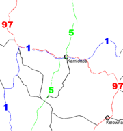
Highway 5 is a north-south route in southern British Columbia
, Canada
. It connects the southern Trans-Canada route (Highway 1) with the northern Yellowhead route (Highway 16), providing the shortest land connection between Vancouver
and Edmonton
. It is 524 km (326 mi) in total length. The portion of Highway 5 south of Kamloops is also known as the Coquihalla Highway, while its northern portion is known as the Southern Yellowhead Highway. The Coquihalla section was a toll road
until 2008.
The current Highway 5 is not the first highway in B.C. to have this designation. Between 1941 and 1953, the section of present-day Highway 97 and Highway 97A between Kaleden
, just north of Osoyoos
, and Salmon Arm
was Highway 5. In 1953, the '5' designation was moved to the route designated today as Highway 5A to the south of Kamloops, and its current route north of Kamloops. In 1986, Highway 5 was re-routed to its present alignment between Hope and Merritt
. The direct route between Merritt and Kamloops was completed in 1987. The total cost for the highway between Hope and Merritt was approximately $848 million.
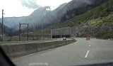
South of Kamloops, Highway 5 is known as the Coquihalla Highway (colloquially "the Coke"), and is a 186 km (116 mi)-long freeway, varying between four and six lanes and having a posted speed limit of 110 km/h (68 mph). The route that the Coquihalla follows through the Cascade Mountains is approximately the same route traced out by the former Kettle Valley Railway
, which existed on this route between 1912 and 1958. It is so-named because it generally follows the Coquihalla River
for about 60 km (37 mi) near Hope
and also uses the Coquihalla Pass
.
In 2003, Premier Gordon Campbell announced that his Liberal
government was going to turn over the operation and maintenance of the Coquihalla, as well as the toll revenue, to a private operator. The public and numerous businesses in the Interior of British Columbia
were strongly opposed to this plan, so the provincial government shelved it three months after its announcement.
On September 26, 2008, the provincial government lifted the Coquihalla tolls permanently, effective 1:00 pm that day. The toll station and signs have since been dismantled.
Although the Yellowhead Highway system is considered part of the Trans-Canada Highway
network, the Highway 5 segment is not marked as such.

 Highway 5 begins in the south at its junction with Highway 3
at an uninhabited location known as "Othello," 7 km (4 mi) east of Hope
(named after a nearby siding on the Kettle Valley Railway, which used many Shakespearean names). The exit number
s on the Coquihalla are a continuation of those on Highway 1 west of Hope. 35 km (22 mi) north of Othello, after passing through five interchanges, Highway 5 reaches the Great Bear snow shed
, which is a landmark on the route. 13 km (8 mi) north of the snow shed, after passing through another interchange and the 1244 m (4,147 ft) Coquihalla Pass
, Highway 5 reaches the former toll booth; it was the only highway in British Columbia to have toll
s. The toll for a typical passenger vehicle on the highway was C$
10. 61 km (38 mi) and five interchanges later, the Coquihalla enters the city of Merritt
at its south junction with Highway 5A and Highway 97C.
 Highway 5 then goes 4 km (2½ mi) through the eastern area of Merritt before reaching its northern junction with Highway 5A. The Coquihalla has three more interchanges and one mountain pass, the Clapperton Creek Summit
, in its remaining 72 km (45 mi) between Merritt and its end at a junction with Highways 1 and 97 within the Afton area of Kamloops. Highway 5 continues east for 7 km (4 mi) concurrent with Highways 1 and 97 through Kamloops. This stretch of road, which carries 97 South and 5 North on the same lanes (and vice versa), is the only wrong-way concurrency in British Columbia.
After separating from Highways 1 and 97, Highway 5 proceeds north for approximately 19 km (12 mi), temporarily leaving Kamloops city limits as a four-lane highway, before re-entering the city at the Rayleigh
community and continuing north. It becomes a two-lane highway at Heffley Creek
and the exit to Sun Peaks resorts, both of which indicate the final northern boundary of Kamloops.
Highway 5 follows the North Thompson River north from Heffley Creek for approximately 54 km (34 mi), along a parallel course with a branch of the Canadian National Railway
, passing through Barriere
, to a junction with Highway 24 at Little Fort
. 30 km (19 mi) north of Little Fort, while continuing to follow the North Thompson and the CN Railway, Highway 5 reaches the community of Clearwater
. It proceeds northeast for another 107 km (67 mi), passing Vavenby en route, to the community of Blue River
, and then 109 km (68 mi) further north through the Columbia Mountains
, passing by the community of Valemount
to its northern terminus at Tête Jaune Cache
, where it meets Highway 16.
{| class="wikitable"
!Regional District
!|Location
!#
!Destinations
!Notes
|-
!colspan=5|Freeway and exit numbers handed off from Highway 1 from Vancouver
(Trans-Canada Highway
)
|-
|rowspan=17|Fraser Valley
|rowspan=3|Hope
|170
|
|Continuation beyond exit 177
|-
|171
|3rd Avenue
|Westbound exit only
|-
|173
|Old Hope-Princeton Way
|No westbound entrance
|-
|rowspan=4|Othello
|177
|
|
|-
|colspan=3 align=center|Nicolum River Bridge
|-
|colspan=3 align=center|Coquihalla River Bridge
|-
|183
|Othello Road, Kawkawa Lake
|
|-
|rowspan=10|
|192
|Sowaqua Creek Road
|
|-
|195
|Carolin Mines Road
|
|-
|colspan=3 align=center|Ladner Creek Bridge
|-
|200
|Shylock Road
|Southbound exit and northbound entrance
|-
|202
|Portia
|No southbound exit
|-
|colspan=3 align=center|Great Bear Snowshed
|-
|217
|Zopkios rest area
|
|-
|221
|Falls Lake Road
|
|-
|colspan=3 align=center|Coquihalla Summit
(1244 m)
|-
|colspan=3 align=center|Dry Gulch Bridge
|-
|rowspan=24|Thompson-Nicola
|rowspan=5|
|228
|Coquihalla Lakes Road, Britton Creek Rest Area
|
|-
|231
|Mine Creek Road (U-turn)
|Southbound exit and northbound entrance
|-
|238
|Juliet Creek Road, Murray Lake Road, Coldwater River Provincial Park
|
|-
|colspan=3 align=center|Larson Creek Bridge
|-
|250
|Larson Hill, Fig Lake Road, Brodie Siding Road
|
|-
|Kingsvale
|256
|Coldwater Road
|
|-
|
|276
|Comstock Road
|
|-
|rowspan=3|Merritt
|286
|
|
|-
|colspan=3 align=center|Bridge over Nicola River
|-
|290
|
|
|-
|rowspan=2|
|315
|Helmer Road
|
|-
|colspan=3 align=center|Surrey Lake Summit (1444 m)
|-
|Lac Le Jeune
|336
|
|
|-
|
|355
|Inks Lake Road
|
|-
|rowspan=10|Kamloops
|362
|
|
|-
|colspan=3 align=center|South end of Hwy 1/Hwy 97 overlap
|-
|366
|Copperhead Drive, Lac le Jeune Road
|
|-
|367
|Pacific Way
|
|-
|368
|
|
|-
|369
|Columbia Street W, Notre Dame Drive, Kamloops City Centre
|Eastbound exit and westbound entrance
|-
|370
|Notre Dame Drive, Summit Drive, Kamloops City Centre
|Westbound exit and eastbound entrance
|-
|374
|, Calgary
|Highway 5 exits freeway, Hwy 1 continues freeway and exit numbers
North end of Hwy 1/Hwy 97 overlap
|-
|
|Valleyview Road
|Southbound exit only
|-
|colspan=3 align=center|Yellowhead Bridge
over South Thompson River
|-
!colspan=5|Highway 5 continues toward Clearwater
, Valemount
as 2/4 lane highway
, is a place name meaning "stingy container". It refers specifically to a fishing rock near the mouth of what is now known as the Coquihalla River. This rock is a good platform for spearing salmon. According to Stó:lō oral history, the skw'exweq (water babies, underwater people) who inhabit a pool close by the rock, would swim out and pull the salmon off the spears, allowing only certain fisherman to catch the salmon.
The route is also often referred to simply as "The Coke." A popular song by country singer Corb Lund, entitled "Hurtin' Albertan", makes reference to this, with the lyric "...there's good weather up on the Coke."
Also, the Calgary punk Band Chixdiggit sing about this highway in their song "I Drove the Coquihalla".
British Columbia
British Columbia is the westernmost of Canada's provinces and is known for its natural beauty, as reflected in its Latin motto, Splendor sine occasu . Its name was chosen by Queen Victoria in 1858...
, Canada
Canada
Canada is a North American country consisting of ten provinces and three territories. Located in the northern part of the continent, it extends from the Atlantic Ocean in the east to the Pacific Ocean in the west, and northward into the Arctic Ocean...
. It connects the southern Trans-Canada route (Highway 1) with the northern Yellowhead route (Highway 16), providing the shortest land connection between Vancouver
Vancouver
Vancouver is a coastal seaport city on the mainland of British Columbia, Canada. It is the hub of Greater Vancouver, which, with over 2.3 million residents, is the third most populous metropolitan area in the country,...
and Edmonton
Edmonton
Edmonton is the capital of the Canadian province of Alberta and is the province's second-largest city. Edmonton is located on the North Saskatchewan River and is the centre of the Edmonton Capital Region, which is surrounded by the central region of the province.The city and its census...
. It is 524 km (326 mi) in total length. The portion of Highway 5 south of Kamloops is also known as the Coquihalla Highway, while its northern portion is known as the Southern Yellowhead Highway. The Coquihalla section was a toll road
Toll road
A toll road is a privately or publicly built road for which a driver pays a toll for use. Structures for which tolls are charged include toll bridges and toll tunnels. Non-toll roads are financed using other sources of revenue, most typically fuel tax or general tax funds...
until 2008.
The current Highway 5 is not the first highway in B.C. to have this designation. Between 1941 and 1953, the section of present-day Highway 97 and Highway 97A between Kaleden
Kaleden, British Columbia
Kaleden is a small historic community located minutes south of Penticton in the Okanagan valley in the province of British Columbia Canada. Overlooking Skaha Lake, Kaleden is made up of picturesque vineyards and lakeview orchards. Visitors are offered a relaxed environment with good bed and...
, just north of Osoyoos
Osoyoos, British Columbia
Osoyoos is a town in the southern part of the Okanagan Valley in British Columbia near the border with Washington state. The town is also adjacent to the Indian Reserve of the Osoyoos Indian Band. The origin of the name Osoyoos was the word suius meaning "narrowing of the waters" in the local...
, and Salmon Arm
Salmon Arm, British Columbia
-Climate:- Education :Public schools in Salmon Arm are part of School District 83 North Okanagan-Shuswap; within the city limits, there are currently five elementary schools , one middle school , and a secondary school with two campuses...
was Highway 5. In 1953, the '5' designation was moved to the route designated today as Highway 5A to the south of Kamloops, and its current route north of Kamloops. In 1986, Highway 5 was re-routed to its present alignment between Hope and Merritt
Merritt, British Columbia
Merritt is a city in the Nicola Valley of the south-central Interior of British Columbia, Canada. Situated at the confluence of the Nicola and Coldwater rivers, it is the first major community encountered after travelling along Phase One of the Coquihalla Highway and acts as the gateway to all...
. The direct route between Merritt and Kamloops was completed in 1987. The total cost for the highway between Hope and Merritt was approximately $848 million.
South of Kamloops, Highway 5 is known as the Coquihalla Highway (colloquially "the Coke"), and is a 186 km (116 mi)-long freeway, varying between four and six lanes and having a posted speed limit of 110 km/h (68 mph). The route that the Coquihalla follows through the Cascade Mountains is approximately the same route traced out by the former Kettle Valley Railway
Kettle Valley Railway
The Kettle Valley Railroad was a subsidiary of the Canadian Pacific Railway that operated in the Thompson-Okanagan region of southern British Columbia....
, which existed on this route between 1912 and 1958. It is so-named because it generally follows the Coquihalla River
Coquihalla River
The Coquihalla River is located in the Cascade Mountains near the town of Hope, British Columbia. It originates in the Coquihalla Lakes and empties into the Fraser River at Hope....
for about 60 km (37 mi) near Hope
Hope, British Columbia
Hope is a district municipality located at the confluence of the Fraser and Coquihalla rivers in the province of British Columbia, Canada. Hope is at the eastern end of both the Fraser Valley and the Lower Mainland region, and is at the southern end of the Fraser Canyon...
and also uses the Coquihalla Pass
Coquihalla Pass
Coquihalla Summit is a highway summit along the Coquihalla Highway in British Columbia, Canada. It is the highest point on the highway between the cities of Hope and Merritt...
.
In 2003, Premier Gordon Campbell announced that his Liberal
British Columbia Liberal Party
The British Columbia Liberal Party is the governing political party in British Columbia, Canada. First elected for government in 1916, the party went into decline after 1952, with its rump caucus merging with the Social Credit Party for the 1975 election...
government was going to turn over the operation and maintenance of the Coquihalla, as well as the toll revenue, to a private operator. The public and numerous businesses in the Interior of British Columbia
British Columbia Interior
The British Columbia Interior or BC Interior or Interior of British Columbia, usually referred to only as the Interior, is one of the three main regions of the Canadian province of British Columbia, the other two being the Lower Mainland, which comprises the overlapping areas of Greater Vancouver...
were strongly opposed to this plan, so the provincial government shelved it three months after its announcement.
On September 26, 2008, the provincial government lifted the Coquihalla tolls permanently, effective 1:00 pm that day. The toll station and signs have since been dismantled.
Although the Yellowhead Highway system is considered part of the Trans-Canada Highway
Trans-Canada Highway
The Trans-Canada Highway is a federal-provincial highway system that joins the ten provinces of Canada. It is, along with the Trans-Siberian Highway and Australia's Highway 1, one of the world's longest national highways, with the main route spanning 8,030 km...
network, the Highway 5 segment is not marked as such.
Route details
Crowsnest Highway
The Crowsnest Highway, also known as the Interprovincial or, in British Columbia, the Southern Trans-Provincial, is an east-west highway, in length, through the southern parts of British Columbia and Alberta, providing the shortest highway connection between British Columbia's Lower Mainland and...
at an uninhabited location known as "Othello," 7 km (4 mi) east of Hope
Hope, British Columbia
Hope is a district municipality located at the confluence of the Fraser and Coquihalla rivers in the province of British Columbia, Canada. Hope is at the eastern end of both the Fraser Valley and the Lower Mainland region, and is at the southern end of the Fraser Canyon...
(named after a nearby siding on the Kettle Valley Railway, which used many Shakespearean names). The exit number
Exit number
An exit number is a number assigned to a road junction, usually an exit from a freeway. It is usually marked on the same sign as the destinations of the exit, as well as a sign in the gore....
s on the Coquihalla are a continuation of those on Highway 1 west of Hope. 35 km (22 mi) north of Othello, after passing through five interchanges, Highway 5 reaches the Great Bear snow shed
Snow shed
An avalanche snow bridge or simply snow bridge is a type of rigid snow-supporting structure for avalanche control . Avalanche bridges can be made of steel, prestressed concrete frames, or timber....
, which is a landmark on the route. 13 km (8 mi) north of the snow shed, after passing through another interchange and the 1244 m (4,147 ft) Coquihalla Pass
Coquihalla Pass
Coquihalla Summit is a highway summit along the Coquihalla Highway in British Columbia, Canada. It is the highest point on the highway between the cities of Hope and Merritt...
, Highway 5 reaches the former toll booth; it was the only highway in British Columbia to have toll
Toll road
A toll road is a privately or publicly built road for which a driver pays a toll for use. Structures for which tolls are charged include toll bridges and toll tunnels. Non-toll roads are financed using other sources of revenue, most typically fuel tax or general tax funds...
s. The toll for a typical passenger vehicle on the highway was C$
Canadian dollar
The Canadian dollar is the currency of Canada. As of 2007, the Canadian dollar is the 7th most traded currency in the world. It is abbreviated with the dollar sign $, or C$ to distinguish it from other dollar-denominated currencies...
10. 61 km (38 mi) and five interchanges later, the Coquihalla enters the city of Merritt
Merritt, British Columbia
Merritt is a city in the Nicola Valley of the south-central Interior of British Columbia, Canada. Situated at the confluence of the Nicola and Coldwater rivers, it is the first major community encountered after travelling along Phase One of the Coquihalla Highway and acts as the gateway to all...
at its south junction with Highway 5A and Highway 97C.
Clapperton Creek Summit
Clapperton Creek Summit is a highway summit in British Columbia, Canada. It is the highest point on British Columbia Highway 5, and is located between Merritt and Kamloops....
, in its remaining 72 km (45 mi) between Merritt and its end at a junction with Highways 1 and 97 within the Afton area of Kamloops. Highway 5 continues east for 7 km (4 mi) concurrent with Highways 1 and 97 through Kamloops. This stretch of road, which carries 97 South and 5 North on the same lanes (and vice versa), is the only wrong-way concurrency in British Columbia.
After separating from Highways 1 and 97, Highway 5 proceeds north for approximately 19 km (12 mi), temporarily leaving Kamloops city limits as a four-lane highway, before re-entering the city at the Rayleigh
Rayleigh, British Columbia
In May 1973, the municipality of Rayleigh, British Columbia was added to the city of Kamloops, located on the east side of the North Thompson River to the south of the community of Heffley Creek, also part of the City of Kamloops. A former post office here was named Rayleigh Mount. This post...
community and continuing north. It becomes a two-lane highway at Heffley Creek
Heffley Creek, British Columbia
Heffley Creek is a neighbourhood along the Yellowhead Highway in Kamloops, British Columbia, Canada. Heffley Creek is bordered by the Thompson River to the West, Sun Peaks to the east, Rayleigh to the south, and Vinsula to the north. It contains a neighbourhood general store, community hall and...
and the exit to Sun Peaks resorts, both of which indicate the final northern boundary of Kamloops.
Highway 5 follows the North Thompson River north from Heffley Creek for approximately 54 km (34 mi), along a parallel course with a branch of the Canadian National Railway
Canadian National Railway
The Canadian National Railway Company is a Canadian Class I railway headquartered in Montreal, Quebec. CN's slogan is "North America's Railroad"....
, passing through Barriere
Barriere, British Columbia
Barriere is a district municipality in central British Columbia, Canada, located 66 km north of the larger city of Kamloops on Highway 5. It is situated at the confluence of the Barriere and North Thompson Rivers in the Central North Thompson Valley...
, to a junction with Highway 24 at Little Fort
Little Fort, British Columbia
Little Fort is a small community on the west bank of North Thompson River in the interior of British Columbia, Canada. It is some north of Kamloops.The community is located at the junction of Highway 5 and Highway 24 in British Columbia, Canada...
. 30 km (19 mi) north of Little Fort, while continuing to follow the North Thompson and the CN Railway, Highway 5 reaches the community of Clearwater
Clearwater, British Columbia
Clearwater is a district municipality in the North Thompson River valley in British Columbia, Canada, north of Kamloops. The largest community in the valley, with a population of 4,960, Clearwater is predominantly employed by the forestry industry. Tourism is also a major industry, with Wells Gray...
. It proceeds northeast for another 107 km (67 mi), passing Vavenby en route, to the community of Blue River
Blue River, British Columbia
Blue River is a small community in British Columbia, situated on the Yellowhead Highway about halfway between Kamloops and Jasper, Alberta, located at the confluence of the Blue and North Thompson Rivers. It currently has 260 residents...
, and then 109 km (68 mi) further north through the Columbia Mountains
Columbia Mountains
The Columbia Mountains are a group of mountain ranges located in southeastern British Columbia, and partially in Montana, Idaho and Washington. The mountain range covers 135,952 km² . The range is bounded by the Rocky Mountain Trench on the east, and the Kootenay River on the south; their...
, passing by the community of Valemount
Valemount, British Columbia
Valemount is a village of 1,018 people in east central British Columbia, Canada. It is situated between the Rocky, Monashee, and Cariboo Mountains. It is the nearest community to the west of Jasper National Park, and is also the nearest community to Mount Robson Provincial Park, which features...
to its northern terminus at Tête Jaune Cache
Tête Jaune Cache, British Columbia
Tête Jaune Cache is an unincorporated rural area and the site of an important abandoned historic town in British Columbia, Canada. Its population is approximately 500. It is located on the Fraser River in the Robson Valley at the intersection of Yellowhead Highways 5 and 16...
, where it meets Highway 16.
Exit list
From south to north, the following intersections are observed along Highway 5:{| class="wikitable"
!Regional District
Regional districts of British Columbia
The Canadian province of British Columbia is divided into regional districts. Like counties in other parts of Canada, regional districts serve only to provide municipal services as the local government in areas not incorporated into a municipality, and in certain regional affairs of shared concern...
!|Location
!#
Exit number
An exit number is a number assigned to a road junction, usually an exit from a freeway. It is usually marked on the same sign as the destinations of the exit, as well as a sign in the gore....
!Destinations
!Notes
|-
!colspan=5|Freeway and exit numbers handed off from Highway 1 from Vancouver
Vancouver
Vancouver is a coastal seaport city on the mainland of British Columbia, Canada. It is the hub of Greater Vancouver, which, with over 2.3 million residents, is the third most populous metropolitan area in the country,...
(Trans-Canada Highway
Trans-Canada Highway
The Trans-Canada Highway is a federal-provincial highway system that joins the ten provinces of Canada. It is, along with the Trans-Siberian Highway and Australia's Highway 1, one of the world's longest national highways, with the main route spanning 8,030 km...
)
|-
|rowspan=17|Fraser Valley
Fraser Valley Regional District
The Fraser Valley Regional District is a regional district in British Columbia, Canada. The FVRD covers an area of 13,361.74 km²...
|rowspan=3|Hope
Hope, British Columbia
Hope is a district municipality located at the confluence of the Fraser and Coquihalla rivers in the province of British Columbia, Canada. Hope is at the eastern end of both the Fraser Valley and the Lower Mainland region, and is at the southern end of the Fraser Canyon...
|170
|
|Continuation beyond exit 177
|-
|171
|3rd Avenue
|Westbound exit only
|-
|173
|Old Hope-Princeton Way
|No westbound entrance
|-
|rowspan=4|Othello
|177
|
|
|-
|colspan=3 align=center|Nicolum River Bridge
Nicolum River
The Nicolum River, formerly Nicolum Creek, is a tributary of the Coquihalla River, rising in the Cascade Mountains and flowing northwest to join that stream near the town of Hope, British Columbia, Canada...
|-
|colspan=3 align=center|Coquihalla River Bridge
Coquihalla River
The Coquihalla River is located in the Cascade Mountains near the town of Hope, British Columbia. It originates in the Coquihalla Lakes and empties into the Fraser River at Hope....
|-
|183
|Othello Road, Kawkawa Lake
|
|-
|rowspan=10|
|192
|Sowaqua Creek Road
|
|-
|195
|Carolin Mines Road
|
|-
|colspan=3 align=center|Ladner Creek Bridge
|-
|200
|Shylock Road
|Southbound exit and northbound entrance
|-
|202
|Portia
|No southbound exit
|-
|colspan=3 align=center|Great Bear Snowshed
|-
|217
|Zopkios rest area
|
|-
|221
|Falls Lake Road
|
|-
|colspan=3 align=center|Coquihalla Summit
Coquihalla Pass
Coquihalla Summit is a highway summit along the Coquihalla Highway in British Columbia, Canada. It is the highest point on the highway between the cities of Hope and Merritt...
(1244 m)
|-
|colspan=3 align=center|Dry Gulch Bridge
|-
|rowspan=24|Thompson-Nicola
|rowspan=5|
|228
|Coquihalla Lakes Road, Britton Creek Rest Area
|
|-
|231
|Mine Creek Road (U-turn)
|Southbound exit and northbound entrance
|-
|238
|Juliet Creek Road, Murray Lake Road, Coldwater River Provincial Park
Coldwater River Provincial Park
Coldwater River Provincial Park is a provincial park in British Columbia, Canada, located at the confluence of the Coldwater River with Cullet Creek, 50 km south of Merritt on BC Highway 5.-References:*...
|
|-
|colspan=3 align=center|Larson Creek Bridge
|-
|250
|Larson Hill, Fig Lake Road, Brodie Siding Road
|
|-
|Kingsvale
|256
|Coldwater Road
|
|-
|
|276
|Comstock Road
|
|-
|rowspan=3|Merritt
Merritt, British Columbia
Merritt is a city in the Nicola Valley of the south-central Interior of British Columbia, Canada. Situated at the confluence of the Nicola and Coldwater rivers, it is the first major community encountered after travelling along Phase One of the Coquihalla Highway and acts as the gateway to all...
|286
|
|
|-
|colspan=3 align=center|Bridge over Nicola River
Nicola River
The Nicola River, originally French Rivière de Nicholas or Rivière de Nicolas, adapted to Nicolas River, Nicola's River in English, , is one of the major tributaries of the Thompson River in the Canadian province of British Columbia, entering the latter at the town of Spences Bridge...
|-
|290
|
|
|-
|rowspan=2|
|315
|Helmer Road
|
|-
|colspan=3 align=center|Surrey Lake Summit (1444 m)
|-
|Lac Le Jeune
Lac le Jeune, British Columbia
Lac le Jeune is a settlement in British Columbia....
|336
|
|
|-
|
|355
|Inks Lake Road
|
|-
|rowspan=10|Kamloops
|362
|
|
|-
|colspan=3 align=center|South end of Hwy 1/Hwy 97 overlap
|-
|366
|Copperhead Drive, Lac le Jeune Road
|
|-
|367
|Pacific Way
|
|-
|368
|
|
|-
|369
|Columbia Street W, Notre Dame Drive, Kamloops City Centre
|Eastbound exit and westbound entrance
|-
|370
|Notre Dame Drive, Summit Drive, Kamloops City Centre
|Westbound exit and eastbound entrance
|-
|374
|, Calgary
|Highway 5 exits freeway, Hwy 1 continues freeway and exit numbers
North end of Hwy 1/Hwy 97 overlap
|-
|
|Valleyview Road
|Southbound exit only
|-
|colspan=3 align=center|Yellowhead Bridge
Yellowhead Bridge (Kamloops)
The Yellowhead Bridge is a road bridge in Kamloops, British Columbia. It carries Highway 5 over the South Thompson River. It was completed in 1967.-See also:* List of crossings of the Thompson River* List of bridges in Canada...
over South Thompson River
Thompson River
The Thompson River is the largest tributary of the Fraser River, flowing through the south-central portion of British Columbia, Canada. The Thompson River has two main branches called the South Thompson and the North Thompson...
|-
!colspan=5|Highway 5 continues toward Clearwater
Clearwater, British Columbia
Clearwater is a district municipality in the North Thompson River valley in British Columbia, Canada, north of Kamloops. The largest community in the valley, with a population of 4,960, Clearwater is predominantly employed by the forestry industry. Tourism is also a major industry, with Wells Gray...
, Valemount
Valemount, British Columbia
Valemount is a village of 1,018 people in east central British Columbia, Canada. It is situated between the Rocky, Monashee, and Cariboo Mountains. It is the nearest community to the west of Jasper National Park, and is also the nearest community to Mount Robson Provincial Park, which features...
as 2/4 lane highway
Trivia
Kw'ikw'iya:la (Coquihalla) in the Halq'emeylem language of the Stó:lōStó:lo
The Sto:lo , alternately written as Stó:lō, Stó:lô or Stó:lõ and historically as Staulo or Stahlo, and historically known and commonly referred to in ethnographic literature as the Fraser River Indians or Lower Fraser Salish, are a group of First Nations peoples inhabiting the Fraser Valley of...
, is a place name meaning "stingy container". It refers specifically to a fishing rock near the mouth of what is now known as the Coquihalla River. This rock is a good platform for spearing salmon. According to Stó:lō oral history, the skw'exweq (water babies, underwater people) who inhabit a pool close by the rock, would swim out and pull the salmon off the spears, allowing only certain fisherman to catch the salmon.
The route is also often referred to simply as "The Coke." A popular song by country singer Corb Lund, entitled "Hurtin' Albertan", makes reference to this, with the lyric "...there's good weather up on the Coke."
Also, the Calgary punk Band Chixdiggit sing about this highway in their song "I Drove the Coquihalla".