
Osoyoos, British Columbia
Encyclopedia
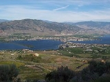
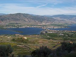
Osoyoos is a town in the southern part of the Okanagan
Valley in British Columbia
near the border with Washington state. The town is also adjacent to the Indian Reserve
of the Osoyoos Indian Band
. The origin of the name Osoyoos was the word suius meaning "narrowing of the waters" in the local Okanagan language (Syilx'tsn). The "O-" prefix is not indigenous in origin and was attached by settler-promoters wanting to harmonize the name with other O-names in the Okanagan region (Oliver, Omak, Oroville, Okanagan).
The town’s population of just over 5,000 according to the 2010 BC Stats estimates (with another 1921 people surrounding the town in Okanagan-Similkameen Electoral Area A according to the 2006 Statscan census) swells in the summer months with visitors from elsewhere in British Columbia and neighbouring Alberta
, as well as elsewhere in Canada. There is also a newer contingent of international visitors, supported by the proximity to the Kelowna International Airport
about 1.5 hours north of the town. There is also a rapidly growing year-round retiree population as is evident with the recent boom of condominium and suburban development (though somewhat thwarted by the 2008-2009 economic downturn).
The first Europeans to Osoyoos were fur traders working for the Pacific Fur Company
, an American enterprise. They ventured up the Okanagan River to Osoyoos Lake
and farther north. After the Hudson’s Bay Company took over the fur trade in 1821, the Okanagan Valley became a major trade route for supplies to inland forts of British Columbia and furs that were shipped south to the Columbia River
and the Pacific to European and Asian markets. The final Hudson’s Bay Company brigade
in 1860 was the end of an era, as gold rushes
transformed the economy of the new Colony of British Columbia
. As parties of miners headed for the Fraser goldfields
via the Okanagan Trail
, they commonly met conflict with the Okanagan people
.
Thousands of miners heading to the goldfields and drovers with large herds of livestock crossed the 49th parallel after 1858. A custom house was built in Osoyoos in 1861 with John Carmichael Haynes the tax collector. Haynes was also the first pioneer settler who obtained land along the Okanagan River north of Osoyoos that had been part of the Osoyoos Indian Reserve established by the Joint Indian Reserve Commissionin 1877. These lands, now known as the Haynes Lease lands, can still be visited today and are home to an original barn.
Osoyoos was incorporated as a village in 1946 and became a town in the 1980s.
(Highway 3) with a significant ascent out of the Okanagan Valley in either direction. The Crowsnest headed east begins with an 18 km switchback up the flank of the Okanagan Highland
with a 685 m rise to the mining and ranching region of Anarchist Mountain
, which is part of the Boundary Country
(the stretch of rising highway is also referred to as Anarchist Mountain). Highway 3 westbound leads to Keremeos
and the Similkameen Valley
via Richter Pass
. On Highway 97 south, there is a 24 hour border crossing between Canada and the United States
between Osoyoos and Oroville, Washington
. The border crossing is located 4 kilometres (2.5 mi) south of the Highway 3 and 97 intersection on the northwest side of town.
The town is situated on Osoyoos Lake
, which has a perimeter of 47.9 km, an elevation of 276 m, a maximum depth of 63 m and a mean depth of 14 m. The lake’s elevation marks the lowest point in the Okanagan Valley.
The far southern reaches of the Okanagan and Similkameen Valleys are the far northern reaches of the Sonoran Life Zone and include semi-desert landscape species found nowhere else in Canada, including scorpions. While the area is not technically desert, it is part of a threatened ecosystem in Canada
known as shrub-steppe
. Specifically, the ecosystem of the area is named after the Antelope Brush
plant typical of the local climate. This ecosystem was once more prevalent in the South Okanagan but is now becoming fragmented and degraded due to the spread of agriculture, urban development, and other human activities. The area is also sometimes referred to as the Osoyoos Arid Biotic Zone.
Since 2003 there has been an ongoing feasibility study by Parks Canada
to determine the need for protection of a large area of grasslands west of the town known as the South Okanagan-Lower Similkameen National Park Reserve Feasibility Study.
, is semi-arid (BSk) with summers that are generally hot and dry. The result is one of the longest growing seasons in Canada and the highest annual average maximum temperature anywhere in the country. Daily temperatures in July and August average above 30°C (86°F), with overnight lows of around 14°C (57°F) with low humidity. September and October are usually dry and sunny with cool mornings. Winters are short and mild, but can be cold for brief periods during arctic outflow conditions. Spring arrives earlier than other parts of the Okanagan. The table below includes temperature records for the "Osoyoos CS" station (with records from 1990–2010), and precipitation values from the "Osoyoos West" station (with records from 1971–2001). It is important to note that these temperature records are only go back as far as 1990, meaning that higher and lower extremes have likely occurred. Of note, the town of Oliver
just over 20 km north of Osoyoos reached 43.9°C on July 16, 1941 the same day that Lytton
and Lillooet
hit the highest temperature ever recorded in British Columbia of 44.4°C. It is quite possible that on this day that Osoyoos met or surpassed this record as Osoyoos tends to be warmer than Oliver. Numerous websites peg annual sunshine at 2039 hours, however no site sources this fact, it is relatively consistent with other Okanagan communities. It is important to note that the area's climate is variable depending on elevation, for instance, a climate station 25 km northeast of the town in the mountains, records and annual average snowfall of 650 cm.
During the summer months, the southern Okanagan
Valley is among the hottest areas in Canada, and Osoyoos often reaches the highest daytime temperature of any location in Canada. Temperatures typically reach the upper 30s (Celsius) (95-104°F) in the summer for short periods of time. Although it is hot, the humidity is low and nights are generally pleasant. Winters are generally dry and cool, but are usually mild compared to directly adjacent regions.
Okanagan
The Okanagan , also known as the Okanagan Valley and sometimes as Okanagan Country is a region located in the Canadian province of British Columbia defined by the basin of Okanagan Lake and the Canadian portion of the Okanagan River. As of 2009, the region's population is approximately 350,927. The...
Valley in British Columbia
British Columbia
British Columbia is the westernmost of Canada's provinces and is known for its natural beauty, as reflected in its Latin motto, Splendor sine occasu . Its name was chosen by Queen Victoria in 1858...
near the border with Washington state. The town is also adjacent to the Indian Reserve
Indian reserve
In Canada, an Indian reserve is specified by the Indian Act as a "tract of land, the legal title to which is vested in Her Majesty, that has been set apart by Her Majesty for the use and benefit of a band." The Act also specifies that land reserved for the use and benefit of a band which is not...
of the Osoyoos Indian Band
Osoyoos Indian Band
The Osoyoos Indian Band is a First Nations government in the Canadian province of British Columbia, located in the town of Osoyoos in the Okanagan valley, about four kilometres north of the International Border. They are a member of the Okanagan Nation Alliance...
. The origin of the name Osoyoos was the word suius meaning "narrowing of the waters" in the local Okanagan language (Syilx'tsn). The "O-" prefix is not indigenous in origin and was attached by settler-promoters wanting to harmonize the name with other O-names in the Okanagan region (Oliver, Omak, Oroville, Okanagan).
The town’s population of just over 5,000 according to the 2010 BC Stats estimates (with another 1921 people surrounding the town in Okanagan-Similkameen Electoral Area A according to the 2006 Statscan census) swells in the summer months with visitors from elsewhere in British Columbia and neighbouring Alberta
Alberta
Alberta is a province of Canada. It had an estimated population of 3.7 million in 2010 making it the most populous of Canada's three prairie provinces...
, as well as elsewhere in Canada. There is also a newer contingent of international visitors, supported by the proximity to the Kelowna International Airport
Kelowna International Airport
Kelowna International Airport is a Canadian airport located approximately 10 minutes or northeast of Kelowna, British Columbia, Canada, on Highway 97....
about 1.5 hours north of the town. There is also a rapidly growing year-round retiree population as is evident with the recent boom of condominium and suburban development (though somewhat thwarted by the 2008-2009 economic downturn).
History
Aboriginal people have lived in the Osoyoos area for thousands of years, as evidenced by rock and an oral tradition explaining their history before Europeans arrived to the valley in 1811.The first Europeans to Osoyoos were fur traders working for the Pacific Fur Company
Pacific Fur Company
The Pacific Fur Company was founded June 23, 1810, in New York City. Half of the stock of the company was held by the American Fur Company, owned exclusively by John Jacob Astor, and Astor provided all of the capital for the enterprise. The other half of the stock was ascribed to working partners...
, an American enterprise. They ventured up the Okanagan River to Osoyoos Lake
Osoyoos Lake
Osoyoos Lake is a lake located in British Columbia and Washington. Osoyoos is derived from the word suius meaning "narrowing of the waters" in the local Okanagan language ....
and farther north. After the Hudson’s Bay Company took over the fur trade in 1821, the Okanagan Valley became a major trade route for supplies to inland forts of British Columbia and furs that were shipped south to the Columbia River
Columbia River
The Columbia River is the largest river in the Pacific Northwest region of North America. The river rises in the Rocky Mountains of British Columbia, Canada, flows northwest and then south into the U.S. state of Washington, then turns west to form most of the border between Washington and the state...
and the Pacific to European and Asian markets. The final Hudson’s Bay Company brigade
Hudson's Bay Brigade Trail
The Hudson's Bay Brigade Trail, sometimes referred to simply as the Brigade Trail, refers to one of two routes used by Hudson's Bay Company fur traders to transport furs, goods and supplies between coastal and Columbia District headquarters at Fort Vancouver and those in New Caledonia and also in...
in 1860 was the end of an era, as gold rushes
British Columbia Gold Rushes
The presence of gold in the region that is now British Columbia is mentioned in old legends that, in part, led to its discovery. The Strait of Anian, claimed to have been sailed by Juan de Fuca for whom today's Strait of Juan de Fuca is named, was described as passing through a land "rich in gold,...
transformed the economy of the new Colony of British Columbia
Colony of British Columbia
The Colony of British Columbia was a crown colony in British North America from 1858 until 1866. At its creation, it physically constituted approximately half the present day Canadian province of British Columbia, since it did not include the Colony of Vancouver Island, the vast and still largely...
. As parties of miners headed for the Fraser goldfields
Fraser Canyon Gold Rush
The Fraser Canyon Gold Rush, began in 1858 after gold was discovered on the Thompson River in British Columbia at its confluence with the Nicoamen River. This was a few miles upstream from the Thompson's confluence with the Fraser River at present-day Lytton...
via the Okanagan Trail
Okanagan Trail
The Okanagan Trail was an inland route to the Fraser Canyon Gold Rush from the Lower Columbia region of the Washington and Oregon Territories in 1858-1859...
, they commonly met conflict with the Okanagan people
Okanagan people
The Okanagan people, also spelled Okanogan, are a First Nations and Native American people whose traditional territory spans the U.S.-Canada boundary in Washington state and British Columbia...
.
Thousands of miners heading to the goldfields and drovers with large herds of livestock crossed the 49th parallel after 1858. A custom house was built in Osoyoos in 1861 with John Carmichael Haynes the tax collector. Haynes was also the first pioneer settler who obtained land along the Okanagan River north of Osoyoos that had been part of the Osoyoos Indian Reserve established by the Joint Indian Reserve Commissionin 1877. These lands, now known as the Haynes Lease lands, can still be visited today and are home to an original barn.
Osoyoos was incorporated as a village in 1946 and became a town in the 1980s.
Location, Geography & Ecology
Osoyoos is situated on the east-west Crowsnest HighwayCrowsnest Highway
The Crowsnest Highway, also known as the Interprovincial or, in British Columbia, the Southern Trans-Provincial, is an east-west highway, in length, through the southern parts of British Columbia and Alberta, providing the shortest highway connection between British Columbia's Lower Mainland and...
(Highway 3) with a significant ascent out of the Okanagan Valley in either direction. The Crowsnest headed east begins with an 18 km switchback up the flank of the Okanagan Highland
Okanagan Highland
The Okanagan Highland is a plateau-like hilly area in British Columbia, Canada, and the U.S. state of Washington . It lies between the Okanagan Valley on its west and the Kettle River on its east, and geologically is more or less an extension of the Thompson Plateau, which lies west of the Okanagan...
with a 685 m rise to the mining and ranching region of Anarchist Mountain
Anarchist Mountain
Anarchist Mountain is a mountain in British Columbia, Canada, which rises 1491 m above sea level. It is located east of the town of Osoyoos, very near the US border...
, which is part of the Boundary Country
Boundary Country
The Boundary Country is a historical designation for a district in southern British Columbia lying, as its name suggests, along the boundary between Canada and the United States. It lies to the east of the southern Okanagan Valley and to the west of the West Kootenay. It is often included in...
(the stretch of rising highway is also referred to as Anarchist Mountain). Highway 3 westbound leads to Keremeos
Keremeos, British Columbia
Keremeos is a village in the Southern Interior of British Columbia, Canada. The name originated from the Similkameen dialect of the Okanagan language word "Keremeyeus" meaning "creek which cuts its way through the flats" referring to Keremeos Creek which flows down from the Upper Benchlands to the...
and the Similkameen Valley
Similkameen Country
The Similkameen Country, also referred to as the Similkameen Valley or Similkameen District, but generally referred to simply as The Similkameen or more archaically, Similkameen, is a region roughly coinciding with the basin of the river of the same name in the Southern Interior of British Columbia...
via Richter Pass
Richter Pass
Richter Pass is a mountain pass to the south of the summit of British Columbia highway 3 between Keremeos and Osoyoos , linking the Similkameen Valley with the South Okanagan over the southernmost end of the Thompson Plateau...
. On Highway 97 south, there is a 24 hour border crossing between Canada and the United States
United States
The United States of America is a federal constitutional republic comprising fifty states and a federal district...
between Osoyoos and Oroville, Washington
Oroville, Washington
Oroville is a town in Okanogan County, Washington, United States. The population was 1,686 at the 2010 census.-Geography:Oroville is located at ....
. The border crossing is located 4 kilometres (2.5 mi) south of the Highway 3 and 97 intersection on the northwest side of town.
The town is situated on Osoyoos Lake
Osoyoos Lake
Osoyoos Lake is a lake located in British Columbia and Washington. Osoyoos is derived from the word suius meaning "narrowing of the waters" in the local Okanagan language ....
, which has a perimeter of 47.9 km, an elevation of 276 m, a maximum depth of 63 m and a mean depth of 14 m. The lake’s elevation marks the lowest point in the Okanagan Valley.
The far southern reaches of the Okanagan and Similkameen Valleys are the far northern reaches of the Sonoran Life Zone and include semi-desert landscape species found nowhere else in Canada, including scorpions. While the area is not technically desert, it is part of a threatened ecosystem in Canada
Canada
Canada is a North American country consisting of ten provinces and three territories. Located in the northern part of the continent, it extends from the Atlantic Ocean in the east to the Pacific Ocean in the west, and northward into the Arctic Ocean...
known as shrub-steppe
Shrub-steppe
Shrub-steppe is a type of low rainfall natural grassland. Shrub-steppes are distinguishable from deserts, which are too dry to support a noticeable cover of perennial grasses or other shrubs, while the shrub-steppe has sufficient moisture levels to support a cover of perennial grasses and/or...
. Specifically, the ecosystem of the area is named after the Antelope Brush
Purshia tridentata
Purshia tridentata is a nitrogen fixing shrub in the genus Purshia, native to mountainous areas of western North America ranging from southeastern British Columbia in the north, east to Montana and south to California and New Mexico...
plant typical of the local climate. This ecosystem was once more prevalent in the South Okanagan but is now becoming fragmented and degraded due to the spread of agriculture, urban development, and other human activities. The area is also sometimes referred to as the Osoyoos Arid Biotic Zone.
Since 2003 there has been an ongoing feasibility study by Parks Canada
Parks Canada
Parks Canada , also known as the Parks Canada Agency , is an agency of the Government of Canada mandated to protect and present nationally significant natural and cultural heritage, and foster public understanding, appreciation, and enjoyment in ways that ensure their ecological and commemorative...
to determine the need for protection of a large area of grasslands west of the town known as the South Okanagan-Lower Similkameen National Park Reserve Feasibility Study.
Climate
The climate, according to the Köppen climate classificationKöppen climate classification
The Köppen climate classification is one of the most widely used climate classification systems. It was first published by Crimea German climatologist Wladimir Köppen in 1884, with several later modifications by Köppen himself, notably in 1918 and 1936...
, is semi-arid (BSk) with summers that are generally hot and dry. The result is one of the longest growing seasons in Canada and the highest annual average maximum temperature anywhere in the country. Daily temperatures in July and August average above 30°C (86°F), with overnight lows of around 14°C (57°F) with low humidity. September and October are usually dry and sunny with cool mornings. Winters are short and mild, but can be cold for brief periods during arctic outflow conditions. Spring arrives earlier than other parts of the Okanagan. The table below includes temperature records for the "Osoyoos CS" station (with records from 1990–2010), and precipitation values from the "Osoyoos West" station (with records from 1971–2001). It is important to note that these temperature records are only go back as far as 1990, meaning that higher and lower extremes have likely occurred. Of note, the town of Oliver
Oliver, British Columbia
Oliver is a community at the south end of the Okanagan Valley in the Southern Interior of British Columbia, Canada, with a population of 4370. The community of Oliver is made up of land governed by three different bodies: the Town of Oliver, the Regional District of Okanagan-Similkameen and the...
just over 20 km north of Osoyoos reached 43.9°C on July 16, 1941 the same day that Lytton
Lytton, British Columbia
Lytton in British Columbia, Canada, sits at the confluence of the Thompson River and Fraser River on the east side of the Fraser. The location has been inhabited by the Nlaka'pamux people for over 10,000 years, and is one of the earliest locations settled by non-natives in the Southern Interior of...
and Lillooet
Lillooet, British Columbia
Lillooet is a community on the Fraser River in western Canada, about up the British Columbia Railway line from Vancouver. Situated at an intersection of deep gorges in the lee of the Coast Mountains, it has a dry climate- of precipitation is recorded annually at the town's weather station,...
hit the highest temperature ever recorded in British Columbia of 44.4°C. It is quite possible that on this day that Osoyoos met or surpassed this record as Osoyoos tends to be warmer than Oliver. Numerous websites peg annual sunshine at 2039 hours, however no site sources this fact, it is relatively consistent with other Okanagan communities. It is important to note that the area's climate is variable depending on elevation, for instance, a climate station 25 km northeast of the town in the mountains, records and annual average snowfall of 650 cm.
During the summer months, the southern Okanagan
Okanagan
The Okanagan , also known as the Okanagan Valley and sometimes as Okanagan Country is a region located in the Canadian province of British Columbia defined by the basin of Okanagan Lake and the Canadian portion of the Okanagan River. As of 2009, the region's population is approximately 350,927. The...
Valley is among the hottest areas in Canada, and Osoyoos often reaches the highest daytime temperature of any location in Canada. Temperatures typically reach the upper 30s (Celsius) (95-104°F) in the summer for short periods of time. Although it is hot, the humidity is low and nights are generally pleasant. Winters are generally dry and cool, but are usually mild compared to directly adjacent regions.
Average number of days:
- above 20°C (68°F): 153.4 (Max number of days, 1994: 174) Compared to averages 74.6 in Vancouver,
85.5 in Calgary
and 118 in Toronto.
- above 30°C (86°F): 55.1 (Max number of days, 1994: 78) Compared to averages 0.44 in Vancouver, 4.5 in Calgary and 12.6 in Toronto.
Agriculture
Although the fruit-growing possibilities were noticed by the early settlers, it was not until 1907 when the first commercial orchard in the area was established, growing cherries, apricots, peaches, plums, and apples. Osoyoos Orchard Limited was formed in 1920 and an irrigation project was planned which finally brought water to the west bench via “The Ditch” in 1927. The former shrub-steppe environment was transformed into a lush agricultural belt and Osoyoos promoted “the earliest fruit in Canada.”Today, the area continues to produce many of these tender fruit crops. Aside from tourism, agriculture is a major component of the local economy, as is evident by the abundant produce stands along Highways 3 and 97, and the numerous commercial orchards surrounding the town. With the growing popularity of viticulture, some of these orchards are being converted to vineyards, as the area is a major wine producing region
Okanagan Valley (wine region)
The Okanagan Valley is a Canadian wine region located in the British Columbia region of the Okanagan. Along with the nearby Similkameen Valley, the approximately 4000 hectares of vineyards planted in the Okanagan account for more than 90% of all wine produced in British Columbia and after the...
of Canada
Canadian wine
Canadian wine is produced in mainly southern British Columbia and southern Ontario. There is also a growing number of small scale producers of grapes and wine in southern Quebec and Nova Scotia. The two largest wine-producing regions in Canada are the Okanagan Valley of British Columbia and the...
. Some of the main wineries in the area are Nk’Mip, La Stella and Osoyoos Larose.
The vast majority of the land in the valley bottom surrounding the town is protected by the Agricultural Land Reserve
Agricultural Land Reserve
The Agricultural Land Reserve is a collection of land in the Canadian province of British Columbia in which agriculture is recognized as the priority use. Farming is encouraged and non-agricultural uses are controlled. In total, the ALR covers approximately and includes private and public lands...
, which prevents valuable agricultural lands from being converted into other uses.
Tourism
Osoyoos Lake
Osoyoos Lake
Osoyoos Lake is a lake located in British Columbia and Washington. Osoyoos is derived from the word suius meaning "narrowing of the waters" in the local Okanagan language ....
is often believed Canada's warmest lake, with average summer water temperatures of 24°C (75°F) – a claim disputed only by Christina Lake
Christina Lake (British Columbia)
Christina Lake is a lake located along the Crowsnest Highway in the south-central area of British Columbia known as Boundary Country, which separates the Okanagan region from the West Kootenays. It is located 23 kilometers east of Grand Forks, just 1 km north of the United States border...
. The lake is surrounded by kilometres of beaches (public and private), parks and picnic grounds, such as Gyro Beach, Lions Centennial Park, Kinsmen Park, Legion Beach and Haynes Point Provincial Park
Haynes Point Provincial Park
Haynes Point Provincial Park is a provincial park in British Columbia, Canada, located on the west side of Osoyoos Lake in the town of Osoyoos, which is on the United States-Canada border at the southern end of the Okanagan region of British Columbia]]. Now approximately 38 ha...
. There are also major plans to revitalize the waterfront along the town core, spurred on by recent major developments such as the Watermark Beach Resort which include increased public space and an expanded marina.
There are two museums dedicated to the dry landscape of the area, both of which label the area as "Canada's only desert", even though it's not technically desert and other areas of BC are similarly dry and hot. The Osoyoos Desert Centre is located on the west side of town at the junction of Highways 3 and 97, while the Nk'mip Desert
Nk'mip Desert
The Okanagan Desert is the common name for an arid area located in the South Okanagan region of British Columbia, Canada, primarily around Osoyoos Lake. The area, which is technically shrub steppe, has been defined as the Osoyoos Arid Biotic Zone...
Cultural Centre is located adjacent to the Nk'mip Winery on the Osoyoos Indian Reserve.
The area is also served by two golf courses: the Osoyoos Golf and Country Club and the Nk’Mip Canyon Desert Golf Course.
Demographics & Development
As of the 2010 BC Stats estimate, the town has a population of 5203. The town’s popularity among retirees is reflected in the age of the average resident at 58.8 years compared to 40.8 years for the rest of the population of British Columbia. Median household income was $43,764, compared to the $52,709 earned per household on average, province-wide.The area’s increasing aging population, has sparked the need for increased healthcare services. One proposal (known as the Oasis development) currently before town council includes a 5 storey medical-commercial facility. The development also includes three residential buildings between 6 and 10 stories. Despite the town’s small size, there is an abundance of condominium developments.
Sports
| Club | League | Sport | Venue | Established | Championships |
|---|---|---|---|---|---|
| Osoyoos Coyotes Osoyoos Coyotes The Osoyoos Coyotes are a Junior "B" Ice Hockey team based in Osoyoos, British Columbia, Canada. They are members of the Okanagan Division of the Okanagan/Shuswap Conference of the Kootenay International Junior Hockey League... |
Kootenay International Junior Hockey League The Kootenay International Junior Hockey League is a Junior "B" Ice Hockey league in British Columbia, Canada, sanctioned by Hockey Canada. The winner of the KIJHL playoffs competes with the champions of the Pacific International Junior Hockey League and the Vancouver Island Junior Hockey League... |
Ice hockey Ice hockey Ice hockey, often referred to as hockey, is a team sport played on ice, in which skaters use wooden or composite sticks to shoot a hard rubber puck into their opponent's net. The game is played between two teams of six players each. Five members of each team skate up and down the ice trying to take... |
Osoyoos Sunbowl Arena | |
|
Notable residents
Osoyoos is the hometown of the NHLNational Hockey League
The National Hockey League is an unincorporated not-for-profit association which operates a major professional ice hockey league of 30 franchised member clubs, of which 7 are currently located in Canada and 23 in the United States...
's Chuck Kobasew
Chuck Kobasew
Nicholas James "Chuck" Kobasew is a Canadian professional ice hockey right winger currently playing for the Colorado Avalanche of the National Hockey League .-Amateur:...
who plays for the Minnesota Wild
Minnesota Wild
The Minnesota Wild are a professional ice hockey team based in St. Paul, Minnesota, United States. They are members of the Northwest Division of the Western Conference of the National Hockey League ....
and television journalist and anchor Alison Smith
Alison Smith
Alison Smith is a Canadian television and radio journalist and anchor. She graduated in 1972 from Southern Okanagan Secondary School in nearby Oliver, where her father Bruce Smith was a guidance counsellor...
.
Sister cities
Osoyoos has one city in the sister cities programme. Palm Desert, CaliforniaCalifornia
California is a state located on the West Coast of the United States. It is by far the most populous U.S. state, and the third-largest by land area...
, United States
United States
The United States of America is a federal constitutional republic comprising fifty states and a federal district...
External links
- Town of Osoyoos
- Osoyoos Times newspaper
- Osoyoos Commercial Digest
- WikiTravel.org article on Osoyoos
- http://www.bcstats.gov.bc.ca/data/pop/pop/estspop.asp#totpop
- Climate Normals for Osoyoos