
Regional districts of British Columbia
Encyclopedia
The Canadian
province
of British Columbia
is divided into regional districts. Like counties in other parts of Canada, regional districts serve only to provide municipal services as the local government
in areas not incorporated
into a municipality
, and in certain regional affairs of shared concern between residents of unincorporated areas and those in the municipalities such as a stakeholder role in regional planning
. In those predominantly rural areas, regional districts provide services such as land use planning
, building inspection and some responsibility for community fire protection
. Regional districts also provide some services, such as solid-waste management
, but otherwise differ from counties in having no powers or similar bodies with other arms of government whose powers are much more sweeping, including forests, environment, health, schools, provincial and courts. They are not the equivalent of counties and their powers and democratic mandate are substantially weaker. Most land within a regional district is under control of other arms of the provincial government, or in the case of national parks and offshore waters, of the federal government. Indian reserves located within the boundaries of regional districts are likewise excluded from their jurisdiction and infrastructure, and there are varying levels of collaboration between First Nations governments
and regional district boards.
Regional districts are governed by boards of directly and indirectly elected directors. Municipalities appoint directors to represent their populations (usually the mayors), while residents of unincorporated areas (which are grouped into electoral areas) elect directors directly. The votes of directors from municipalities generally count more than the votes of directors from electoral areas, and larger municipalities have more votes than smaller ones. For example, both North Saanich
and Metchosin
appoint one director to the Capital Regional District board of directors, but the vote of North Saanich's director counts three times as much as the vote of Metchosin's appointee.
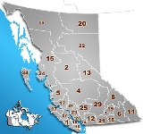
 The current districts, shown with the location of their head offices:
* The Stikine Region is not officially classified as a regional district, and is administered directly by the provincial government.
:
The western half of Dewdney-Alouette, comprising Maple Ridge and Pitt Meadows, was incorporated into the Greater Vancouver Regional District (now Metro Vancouver). Mission and the unincorporated areas east to the Chehalis River were incorporated into the Fraser Valley Regional District.
This amalgamation took place due to the western part of Dewdney-Alouette had become essentially a suburb of Vancouver and would be better served by being within Metro Vancouver. The Central Fraser Valley RD would be nearly completely dominated by the newly amalgamated City of Abbotsford, bringing its role as into question; similarly the remnant of Dewdney-Alouette would be dominated by Mission. Given the rapid growth being experienced in the Fraser Valley at the time, and expected to continue for the foreseeable future, the creation of the Fraser Valley Regional District was seen as the best option.
The Comox-Strathcona Regional District was abolished in February 2008, and replaced by two successor regional districts: Comox Valley and Strathcona.
Canada
Canada is a North American country consisting of ten provinces and three territories. Located in the northern part of the continent, it extends from the Atlantic Ocean in the east to the Pacific Ocean in the west, and northward into the Arctic Ocean...
province
Provinces and territories of Canada
The provinces and territories of Canada combine to make up the world's second-largest country by area. There are ten provinces and three territories...
of British Columbia
British Columbia
British Columbia is the westernmost of Canada's provinces and is known for its natural beauty, as reflected in its Latin motto, Splendor sine occasu . Its name was chosen by Queen Victoria in 1858...
is divided into regional districts. Like counties in other parts of Canada, regional districts serve only to provide municipal services as the local government
Local government
Local government refers collectively to administrative authorities over areas that are smaller than a state.The term is used to contrast with offices at nation-state level, which are referred to as the central government, national government, or federal government...
in areas not incorporated
Unincorporated area
In law, an unincorporated area is a region of land that is not a part of any municipality.To "incorporate" in this context means to form a municipal corporation, a city, town, or village with its own government. An unincorporated community is usually not subject to or taxed by a municipal government...
into a municipality
Municipality
A municipality is essentially an urban administrative division having corporate status and usually powers of self-government. It can also be used to mean the governing body of a municipality. A municipality is a general-purpose administrative subdivision, as opposed to a special-purpose district...
, and in certain regional affairs of shared concern between residents of unincorporated areas and those in the municipalities such as a stakeholder role in regional planning
Regional planning
Regional planning deals with the efficient placement of land use activities, infrastructure, and settlement growth across a larger area of land than an individual city or town. The related field of urban planning deals with the specific issues of city planning...
. In those predominantly rural areas, regional districts provide services such as land use planning
Land use planning
Land-use planning is the term used for a branch of public policy encompassing various disciplines which seek to order and regulate land use in an efficient and ethical way, thus preventing land-use conflicts. Governments use land-use planning to manage the development of land within their...
, building inspection and some responsibility for community fire protection
Fire protection
Fire protection is the study and practice of mitigating the unwanted effects of fires. It involves the study of the behaviour, compartmentalisation, suppression and investigation of fire and its related emergencies, as well as the research and development, production, testing and application of...
. Regional districts also provide some services, such as solid-waste management
Waste management
Waste management is the collection, transport, processing or disposal,managing and monitoring of waste materials. The term usually relates to materials produced by human activity, and the process is generally undertaken to reduce their effect on health, the environment or aesthetics...
, but otherwise differ from counties in having no powers or similar bodies with other arms of government whose powers are much more sweeping, including forests, environment, health, schools, provincial and courts. They are not the equivalent of counties and their powers and democratic mandate are substantially weaker. Most land within a regional district is under control of other arms of the provincial government, or in the case of national parks and offshore waters, of the federal government. Indian reserves located within the boundaries of regional districts are likewise excluded from their jurisdiction and infrastructure, and there are varying levels of collaboration between First Nations governments
First Nations Government (Canada)
The fundamental legal unit of government for Canadian First Nations is the band.-Band:A band is typically, but not always, composed of a single community. Many bands, especially in British Columbia, control multiple Indian reserves, that is, multiple parcels of land...
and regional district boards.
Regional districts are governed by boards of directly and indirectly elected directors. Municipalities appoint directors to represent their populations (usually the mayors), while residents of unincorporated areas (which are grouped into electoral areas) elect directors directly. The votes of directors from municipalities generally count more than the votes of directors from electoral areas, and larger municipalities have more votes than smaller ones. For example, both North Saanich
North Saanich, British Columbia
North Saanich is located on the Saanich Peninsula, approximately 25 km north of Victoria, British Columbia on southern Vancouver Island...
and Metchosin
Metchosin, British Columbia
The District of Metchosin is a small, coastal community in the metro Greater Victoria region of British Columbia. It is part of the Western Communities and one of the 13 regional municipalities. Many Metchosinites are small farmers . Most are retired or work outside the community...
appoint one director to the Capital Regional District board of directors, but the vote of North Saanich's director counts three times as much as the vote of Metchosin's appointee.
Current regional districts
- Alberni-Clayoquot Regional District (Port Alberni)
- Regional District of Bulkley-Nechako (Burns LakeBurns Lake, British Columbiathumb|309px|right|Burns Lake's welcome signBurns Lake is a rural village in the North-Central Interior of British Columbia, Canada, incorporated in 1923...
) - Capital Regional District (VictoriaVictoria, British ColumbiaVictoria is the capital city of British Columbia, Canada and is located on the southern tip of Vancouver Island off Canada's Pacific coast. The city has a population of about 78,000 within the metropolitan area of Greater Victoria, which has a population of 360,063, the 15th most populous Canadian...
) - Cariboo Regional District (Williams LakeWilliams Lake, British ColumbiaWilliams Lake, is a city in the Central Interior of British Columbia, Canada. Located in the central part of a region known as the Cariboo, it is the largest urban centre between Kamloops and Prince George, with a population of 11,150 in city limits....
) - Central Coast Regional District (Bella CoolaBella Coola, British ColumbiaBella Coola is a community of approximately 600 at the western extremity of the Bella Coola Valley. Bella Coola usually refers to the entire valley, encompassing the settlements of Bella Coola proper , Lower Bella Coola, Hagensborg, Saloompt, Nusatsum, Firvale and Stuie...
) - Regional District of Central Kootenay (NelsonNelson, British ColumbiaNelson is a city located in the Selkirk Mountains on the extreme West Arm of Kootenay Lake in the Southern Interior of British Columbia, Canada. Known as "The Queen City", and acknowledged for its impressive collection of restored heritage buildings from its glory days in a regional silver rush,...
) - Regional District of Central Okanagan (KelownaKelownaKelowna is a city on Okanagan Lake in the Okanagan Valley, in the southern interior of British Columbia, Canada. Its name derives from a Okanagan language term for "grizzly bear"...
) - Columbia-Shuswap Regional District (Salmon ArmSalmon Arm, British Columbia-Climate:- Education :Public schools in Salmon Arm are part of School District 83 North Okanagan-Shuswap; within the city limits, there are currently five elementary schools , one middle school , and a secondary school with two campuses...
) - Comox Valley Regional District (CourtenayCourtenay, British ColumbiaCourtenay is a city on the east coast of Vancouver Island, in the Canadian province of British Columbia. It is the largest city in the area commonly known as the Comox Valley, and it is the seat of the Comox Valley Regional District which replaced the Comox-Strathcona Regional District...
) - Cowichan Valley Regional District (DuncanDuncan, British ColumbiaDuncan is a city on southern Vancouver Island in British Columbia, Canada.-History:The community is named after William Chalmers Duncan . He arrived in Victoria in May 1862, then in August of that year he was one of the party of a hundred settlers which Governor Douglas took to Cowichan Bay...
) - Regional District of East Kootenay (CranbrookCranbrook, British ColumbiaCranbrook, British Columbia is a city in southeast British Columbia, located on the west side of the Kootenay River at its confluence with the St. Mary's River, It is the largest urban centre in the region known as the East Kootenay. As of 2006, Cranbrook's population is 18,267, and the...
) - Fraser Valley Regional DistrictFraser Valley Regional DistrictThe Fraser Valley Regional District is a regional district in British Columbia, Canada. The FVRD covers an area of 13,361.74 km²...
(ChilliwackChilliwack, British ColumbiaChilliwack is a Canadian city in the Province of British Columbia. It is a predominantly agricultural community with an estimated population of 80,000 people. Chilliwack is the second largest city in the Fraser Valley Regional District after Abbotsford. The city is surrounded by mountains and...
) - Regional District of Fraser-Fort George (Prince GeorgePrince George, British ColumbiaPrince George, with a population of 71,030 , is the largest city in northern British Columbia, Canada, and is known as "BC's Northern Capital"...
) - Greater Vancouver Regional District (aka Metro Vancouver) (Burnaby)
- Regional District of Kitimat-Stikine (TerraceTerrace, British ColumbiaTerrace is a city on the Skeena River in British Columbia, Canada. The Kitselas people, a tribe of the Tsimshian Nation, have lived in the Terrace area for thousands of years. The community population fell between 2001 and 2006 from 12,109 with a regional population of 19,980 to 11,320 and...
) - Regional District of Kootenay BoundaryRegional District of Kootenay BoundaryThe Regional District of Kootenay Boundary is a regional district in the province of British Columbia, Canada. As of the 2006 census, the population was 30,742. The area is 8,095.62 km² . The regional district's offices are in the city of Trail...
(TrailTrail, British ColumbiaTrail is a city in the West Kootenay region of the Interior of British Columbia, Canada.-Geography:Trail has an area of . The city is located on both banks of the Columbia River, approximately 10 km north of the United States border. This section of the Columbia River valley is located between the...
) - Regional District of Mount Waddington (Port McNeillPort McNeill, British ColumbiaPort McNeill is a town in the North Island region of Vancouver Island, British Columbia, Canada with a population of 2,623 . Located on Vancouver Island's north-east shore on Queen Charlotte Strait, it was originally a base camp for loggers, Port McNeill became a settlement in 1936...
) - Regional District of Nanaimo (Nanaimo)
- Regional District of North Okanagan (ColdstreamColdstream, British ColumbiaColdstream is a district municipality in British Columbia, Canada, located at the northern end of Kalamalka Lake in the Okanagan Valley. Incorporated on December 21, 1906, Coldstream celebrated its centennial in 2006. The municipality is directly southeast of Vernon and is considered part of...
) - Northern Rockies Regional Municipality (Fort NelsonFort Nelson, British ColumbiaFort Nelson is a town of approximately 5000 residents in British Columbia's northeastern corner. It is the administrative centre of the newly formed Northern Rockies Regional Municipality, a first for BC. The majority of Fort Nelson's economic activities have historically been concentrated in the...
) - Regional District of Okanagan-Similkameen (Penticton)
- Peace River Regional District (Dawson Creek)
- Powell River Regional District (Powell RiverPowell River, British ColumbiaPowell River is a city on the northern Sunshine Coast of southwestern British Columbia, Canada. Most of its population lives near the eastern shores of Malaspina Strait, that part of the larger Georgia Strait between Texada Island and the Mainland...
) - Skeena-Queen Charlotte Regional District (Prince RupertPrince Rupert, British ColumbiaPrince Rupert is a port city in the province of British Columbia, Canada. It is the land, air, and water transportation hub of British Columbia's North Coast, and home to some 12,815 people .-History:...
) - Squamish-Lillooet Regional District (PembertonPemberton, British ColumbiaPemberton is a village north of Whistler in the Pemberton Valley of British Columbia in Canada, with a population of 2,192. Until the 1960s the village could be accessed only by train but that changed when Highway 99 was built through Whistler and Pemberton.-Climate:The climate of Pemberton is...
) - Stikine RegionStikine RegionThe Stikine Region is an unincorporated area in northwesternmost British Columbia, Canada and is the only area in B.C. not in a regional district...
(n/a)* - Strathcona Regional District (Campbell RiverCampbell River, British ColumbiaCampbell River is a coastal city in British Columbia on the east coast of Vancouver Island at the south end of Discovery Passage, which lies along the important coastal Inside Passage shipping route...
) - Sunshine Coast Regional District (SecheltSechelt, British ColumbiaThe District Municipality of Sechelt is on the lower Sunshine Coast of British Columbia. Approximately 50 km northwest of Vancouver, Sechelt is accessible to the mainland of British Columbia via a 40 minute ferry trip between Horseshoe Bay and Langdale, and a 25 minute drive from Langdale...
) - Thompson-Nicola Regional District (Kamloops)
Historical regional districts
The following regional districts were dissolved in December 1995, and amalgamated largely into the newly formed Fraser Valley Regional DistrictFraser Valley Regional District
The Fraser Valley Regional District is a regional district in British Columbia, Canada. The FVRD covers an area of 13,361.74 km²...
:
- Dewdney-Alouette Regional DistrictDewdney-Alouette Regional DistrictThe Dewdney-Alouette Regional District was a regional district in the Lower Mainland of British Columbia, Canada, comprising the district municipalities of Pitt Meadows, Maple Ridge and Mission and uncincorporated areas east to the Harrison River and north to the southern end of Lillooet Lake...
: MissionMission, British ColumbiaMission, the core of which was formerly known as Mission City, is a district municipality in the province of British Columbia, Canada. It is situated on the north bank of the Fraser River overlooking the City of Abbotsford and with that city is part of the Central Fraser Valley. Mission is the...
, Pitt Meadows, and Maple RidgeMaple Ridge, British ColumbiaMaple Ridge is a District Municipality in British Columbia, located in the northeastern section of Metro Vancouver. Maple Ridge has a population of approximately 68,949.-History:...
, and unincorporated areas north of the Fraser RiverFraser RiverThe Fraser River is the longest river within British Columbia, Canada, rising at Fraser Pass near Mount Robson in the Rocky Mountains and flowing for , into the Strait of Georgia at the city of Vancouver. It is the tenth longest river in Canada...
and west of the District of KentKent, British ColumbiaThe District of Kent is a district municipality located east of Vancouver, British Columbia. Part of the Fraser Valley Regional District, Kent consists of several communities, the largest and most well-known being Agassiz, the only town in the municipality, Harrison Mills, Kilby, Mount Woodside,... - Central Fraser Valley Regional DistrictCentral Fraser Valley Regional DistrictThe Central Fraser Valley Regional District was a regional district in the province of British Columbia, Canada, located in the Lower Mainland region, south of the Fraser River and west of Chilliwack...
: The modern City of AbbotsfordAbbotsford, British ColumbiaAbbotsford is a Canadian city located in the Lower Mainland of British Columbia, adjacent to Greater Vancouver. It is the fifth largest municipality in British Columbia, home to 123,864 people . Its Census Metropolitan Area, which includes the District of Mission, is the 23rd largest in Canada,...
(itself newly formed at the time) and adjacent unincorporated areas - Sumas Mountain (now FVRD Electoral H, west of ChilliwackChilliwack, British ColumbiaChilliwack is a Canadian city in the Province of British Columbia. It is a predominantly agricultural community with an estimated population of 80,000 people. Chilliwack is the second largest city in the Fraser Valley Regional District after Abbotsford. The city is surrounded by mountains and...
and south of the Fraser RiverFraser RiverThe Fraser River is the longest river within British Columbia, Canada, rising at Fraser Pass near Mount Robson in the Rocky Mountains and flowing for , into the Strait of Georgia at the city of Vancouver. It is the tenth longest river in Canada...
. - Regional District of Fraser-CheamRegional District of Fraser-CheamThe Regional District of Fraser-Cheam, commonly called the Fraser-Cheam Regional District, was a regional district in the province of British Columbia, Canada, surrounding the Fraser River from Chiliwack to just south of Lytton. It was created in 1967 but rescinded in 1995. Its area is now part...
: The eastern 2/3 of the modern Fraser Valley Regional District, including Chilliwack, Kent, Harrison Hot SpringsHarrison Hot Springs, British ColumbiaThe Village of Harrison Hot Springs is a small community at the southern end of Harrison Lake in the Fraser Valley of British Columbia. It is a member of the Fraser Valley Regional District; its immediate neighbour is the District of Kent and included in it, the town of Agassiz. It is a resort...
, HopeHope, British ColumbiaHope is a district municipality located at the confluence of the Fraser and Coquihalla rivers in the province of British Columbia, Canada. Hope is at the eastern end of both the Fraser Valley and the Lower Mainland region, and is at the southern end of the Fraser Canyon...
and the Fraser CanyonFraser CanyonThe Fraser Canyon is an 84 km landform of the Fraser River where it descends rapidly through narrow rock gorges in the Coast Mountains en route from the Interior Plateau of British Columbia to the Fraser Valley...
unincorporated areas.
The western half of Dewdney-Alouette, comprising Maple Ridge and Pitt Meadows, was incorporated into the Greater Vancouver Regional District (now Metro Vancouver). Mission and the unincorporated areas east to the Chehalis River were incorporated into the Fraser Valley Regional District.
This amalgamation took place due to the western part of Dewdney-Alouette had become essentially a suburb of Vancouver and would be better served by being within Metro Vancouver. The Central Fraser Valley RD would be nearly completely dominated by the newly amalgamated City of Abbotsford, bringing its role as into question; similarly the remnant of Dewdney-Alouette would be dominated by Mission. Given the rapid growth being experienced in the Fraser Valley at the time, and expected to continue for the foreseeable future, the creation of the Fraser Valley Regional District was seen as the best option.
The Comox-Strathcona Regional District was abolished in February 2008, and replaced by two successor regional districts: Comox Valley and Strathcona.
See also
- List of regional district electoral areas in British Columbia
- Administrative divisions of CanadaAdministrative divisions of CanadaCanada is divided into ten provinces and three territories.Each province has a unique system of local government which may include upper-tier or rural jurisdictions such as counties, municipal districts, regional municipalities, regional districts or regional county municipalities, and lower-tier...
- List of settlements in British Columbia
External links
- Regional district maps
- Local Government Department History, Ministry of Community and Rural Development, British Columbia
- Civic Info BC