
Brighton to Newhaven Cliffs
Encyclopedia
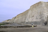
Brighton to Newhaven Cliffs is a 167.5 hectares (413.9 acre) biological and geological Site of Special Scientific Interest
in East Sussex
, England
. The site was notified in 1986 under the Wildlife and Countryside Act 1981
. The site includes two sites before known as Black Rock
and Peacehaven cliffs to Castle Hill.
and lower Campanian
. It is an increasingly important reference section for the Upper Cretaceous.
Black Rock is a key for the study of Quaternary Stratigraphy
and has attracted scientific interest for over 150 years. The modern sea cliff at Black Rock obliquely intersects a fossil cliff and abrasion platform cut in the Upper Chalk.
The platform is overlain by raised beach deposits of sand and shingle which contain shell fragments which amongst other methods have given the beach and cliff a general date from the second half of the last (Ipswichian) interglacial
. The angle between the beach and the old cliff is filled by great quantities of coarse chalk
rubble apparently derived from the
weathering
and erosion
of the cliff in Devensian times. Chalk muds and fine chalk
gravel and grit, are banked against the rubble on the west and may represent fan deposits. The muds contain appreciable quantities of loess
and are overlain by further, coarser solifluction
deposits. The chalk rubble and solifluction deposits are particularly notable for their fossil remains of many Devensian mammals, including Elephas primigenius, Tichorhinus antiquitatus and Equus caballus.
The landforms, stratigraphy
and mammal remains at Black Rock provide an extremely valuable record of former sea level
s and changing environmental conditions during the last few glaciations
which have affected this area, Southern England, unlike much of the rest of the UK
has not been affected by full scale glaciation. An area of the cliff at Saltdean
provides probably the finest example of conjugate normal faults in the Chalk of southern England. This exposure of Upper Chalk lies on the southern flank of the Weald anticline, an upward flexure of the crust and the major geological structure of south-eastern England. The faults run in a north-northeasterly direction, at right angles to the trend of the anticline. These structures were probably formed by stretching of the crust parallel to the axis of the anticline during an episode of crustal compression in the mid Tertiary
. The formation of the Wealden Anticline is related to the formation of the Alpine Chain
to the South.
Along much of the cliffed coast between Brighton and Newhaven (and beyond to Eastbourne), frost involution structures can be seen in the upper meter of the chalk cliff. These involutions appear as repeated 'U' (festoon) shaped structures and date from the Devensisn (last glacial period). Frost heaving broke up the sub-surface sedimentary layers of chalk turning small slabs into a more and more upright orientation towards the surface, to be covered by present day soil. The centre of the 'U' structure is a fill of finer chalk and sands giving a more orange / yellow appearance. These structures have a polygonal surface manifestation which can be revealed by stripping away turf and soil. Slope angle appears to have had an effect on their formation. Where the gradient exceeds 20 degrees solifluction appears to have been a more dominant process preventing their formation. This may link to the patterned ground features of stone nets becoming elongated by gradient resulting in stone stripes as seen in modern periglacial environment and in relic locations such as Dartmoor.
Site of Special Scientific Interest
A Site of Special Scientific Interest is a conservation designation denoting a protected area in the United Kingdom. SSSIs are the basic building block of site-based nature conservation legislation and most other legal nature/geological conservation designations in Great Britain are based upon...
in East Sussex
East Sussex
East Sussex is a county in South East England. It is bordered by the counties of Kent, Surrey and West Sussex, and to the south by the English Channel.-History:...
, England
England
England is a country that is part of the United Kingdom. It shares land borders with Scotland to the north and Wales to the west; the Irish Sea is to the north west, the Celtic Sea to the south west, with the North Sea to the east and the English Channel to the south separating it from continental...
. The site was notified in 1986 under the Wildlife and Countryside Act 1981
Wildlife and Countryside Act 1981
The Wildlife and Countryside Act 1981 is an Act of Parliament in the United Kingdom and was implemented to comply with the Directive 2009/147/EC on the conservation of wild birds...
. The site includes two sites before known as Black Rock
Black Rock (Brighton and Hove)
Black Rock is an area of wasteland located near Brighton Marina in the city of Brighton and Hove.-History:From at least the early 19th Century , Black Rock was the site of an inn and a few houses overlooking cliffs to the east of the then town of Brighton....
and Peacehaven cliffs to Castle Hill.
Geology
Brighton to Newhaven Cliffs provides the best and most extensive exposure of an important chronological fossil site in England. The gentle folding and the ease of access to the cliff exposures make this an important collecting site for faunas of the upper SantonianSantonian
The Santonian is an age in the geologic timescale or a chronostratigraphic stage. It is a subdivision of the Late Cretaceous epoch or Upper Cretaceous series. It spans the time between 85.8 ± 0.7 mya and 83.5 ± 0.7 mya...
and lower Campanian
Campanian
The Campanian is, in the ICS' geologic timescale, the fifth of six ages of the Late Cretaceous epoch . The Campanian spans the time from 83.5 ± 0.7 Ma to 70.6 ± 0.6 Ma ...
. It is an increasingly important reference section for the Upper Cretaceous.
Black Rock is a key for the study of Quaternary Stratigraphy
Quaternary
The Quaternary Period is the most recent of the three periods of the Cenozoic Era in the geologic time scale of the ICS. It follows the Neogene Period, spanning 2.588 ± 0.005 million years ago to the present...
and has attracted scientific interest for over 150 years. The modern sea cliff at Black Rock obliquely intersects a fossil cliff and abrasion platform cut in the Upper Chalk.
The platform is overlain by raised beach deposits of sand and shingle which contain shell fragments which amongst other methods have given the beach and cliff a general date from the second half of the last (Ipswichian) interglacial
Interglacial
An Interglacial period is a geological interval of warmer global average temperature lasting thousands of years that separates consecutive glacial periods within an ice age...
. The angle between the beach and the old cliff is filled by great quantities of coarse chalk
Chalk
Chalk is a soft, white, porous sedimentary rock, a form of limestone composed of the mineral calcite. Calcite is calcium carbonate or CaCO3. It forms under reasonably deep marine conditions from the gradual accumulation of minute calcite plates shed from micro-organisms called coccolithophores....
rubble apparently derived from the
weathering
Weathering
Weathering is the breaking down of rocks, soils and minerals as well as artificial materials through contact with the Earth's atmosphere, biota and waters...
and erosion
Erosion
Erosion is when materials are removed from the surface and changed into something else. It only works by hydraulic actions and transport of solids in the natural environment, and leads to the deposition of these materials elsewhere...
of the cliff in Devensian times. Chalk muds and fine chalk
gravel and grit, are banked against the rubble on the west and may represent fan deposits. The muds contain appreciable quantities of loess
Loess
Loess is an aeolian sediment formed by the accumulation of wind-blown silt, typically in the 20–50 micrometre size range, twenty percent or less clay and the balance equal parts sand and silt that are loosely cemented by calcium carbonate...
and are overlain by further, coarser solifluction
Solifluction
In geology, solifluction, also known as soil fluction, is a type of mass wasting where waterlogged sediment moves slowly downslope, over impermeable material. It occurs in periglacial environments where melting during the warm season leads to water saturation in the thawed surface material ,...
deposits. The chalk rubble and solifluction deposits are particularly notable for their fossil remains of many Devensian mammals, including Elephas primigenius, Tichorhinus antiquitatus and Equus caballus.
The landforms, stratigraphy
Stratigraphy
Stratigraphy, a branch of geology, studies rock layers and layering . It is primarily used in the study of sedimentary and layered volcanic rocks....
and mammal remains at Black Rock provide an extremely valuable record of former sea level
Sea level
Mean sea level is a measure of the average height of the ocean's surface ; used as a standard in reckoning land elevation...
s and changing environmental conditions during the last few glaciations
Glacial period
A glacial period is an interval of time within an ice age that is marked by colder temperatures and glacier advances. Interglacials, on the other hand, are periods of warmer climate within an ice age...
which have affected this area, Southern England, unlike much of the rest of the UK
United Kingdom
The United Kingdom of Great Britain and Northern IrelandIn the United Kingdom and Dependencies, other languages have been officially recognised as legitimate autochthonous languages under the European Charter for Regional or Minority Languages...
has not been affected by full scale glaciation. An area of the cliff at Saltdean
Saltdean
Saltdean is a residential district located on the chalk cliffs of the south coast of England in East Sussex, United Kingdom. It is situated on the eastern edge of the city of Brighton and Hove, with part outside the city boundary in Lewes district...
provides probably the finest example of conjugate normal faults in the Chalk of southern England. This exposure of Upper Chalk lies on the southern flank of the Weald anticline, an upward flexure of the crust and the major geological structure of south-eastern England. The faults run in a north-northeasterly direction, at right angles to the trend of the anticline. These structures were probably formed by stretching of the crust parallel to the axis of the anticline during an episode of crustal compression in the mid Tertiary
Tertiary
The Tertiary is a deprecated term for a geologic period 65 million to 2.6 million years ago. The Tertiary covered the time span between the superseded Secondary period and the Quaternary...
. The formation of the Wealden Anticline is related to the formation of the Alpine Chain
Alps
The Alps is one of the great mountain range systems of Europe, stretching from Austria and Slovenia in the east through Italy, Switzerland, Liechtenstein and Germany to France in the west....
to the South.
Along much of the cliffed coast between Brighton and Newhaven (and beyond to Eastbourne), frost involution structures can be seen in the upper meter of the chalk cliff. These involutions appear as repeated 'U' (festoon) shaped structures and date from the Devensisn (last glacial period). Frost heaving broke up the sub-surface sedimentary layers of chalk turning small slabs into a more and more upright orientation towards the surface, to be covered by present day soil. The centre of the 'U' structure is a fill of finer chalk and sands giving a more orange / yellow appearance. These structures have a polygonal surface manifestation which can be revealed by stripping away turf and soil. Slope angle appears to have had an effect on their formation. Where the gradient exceeds 20 degrees solifluction appears to have been a more dominant process preventing their formation. This may link to the patterned ground features of stone nets becoming elongated by gradient resulting in stone stripes as seen in modern periglacial environment and in relic locations such as Dartmoor.