

Brigalow Belt North
Encyclopedia
Acacia
Acacia is a genus of shrubs and trees belonging to the subfamily Mimosoideae of the family Fabaceae, first described in Africa by the Swedish botanist Carl Linnaeus in 1773. Many non-Australian species tend to be thorny, whereas the majority of Australian acacias are not...
wooded grassland that runs between tropical rainforest
Queensland tropical rain forests
The Queensland tropical rain forests are a terrestrial ecoregion located in northeastern Australia.-Setting:The ecoregion covers of northeastern coastal Queensland, from the coast up a series of plateaus and tablelands to the mountains behind the coast. The ecoregion comprises three separate...
of the coast and the semi-desert interior of Queensland
Queensland
Queensland is a state of Australia, occupying the north-eastern section of the mainland continent. It is bordered by the Northern Territory, South Australia and New South Wales to the west, south-west and south respectively. To the east, Queensland is bordered by the Coral Sea and Pacific Ocean...
, Australia
Australia
Australia , officially the Commonwealth of Australia, is a country in the Southern Hemisphere comprising the mainland of the Australian continent, the island of Tasmania, and numerous smaller islands in the Indian and Pacific Oceans. It is the world's sixth-largest country by total area...
. The Northern and Southern Brigalow Belts are two of the 85 bioregions across Australia and the 15 bioregions (see Interim Biogeographic Regionalisation for Australia
Interim Biogeographic Regionalisation for Australia
The Interim Biogeographic Regionalisation for Australia is a biogeographic regionalisation of Australia developed by the Australian Government's Department of the Environment, Water, Heritage and the Arts...
) in Queensland. Together they form most of the Brigalow tropical savanna ecoregion
Ecoregion
An ecoregion , sometimes called a bioregion, is an ecologically and geographically defined area that is smaller than an ecozone and larger than an ecosystem. Ecoregions cover relatively large areas of land or water, and contain characteristic, geographically distinct assemblages of natural...
.
Location and description
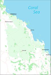
The Northern Brigalow Belt covers just over 13.5 million hectares and reaches down from just north of Townsville, to EmeraldEmerald, Queensland
Emerald is a town located in the Central Highlands district of Central Queensland, Australia. At the 2006 census, Emerald had a population of 10,999. The town is the business centre for the Central Highlands Regional Council....
and Rockhampton
Rockhampton
Rockhampton can refer to:* Rockhampton, Queensland is a city in Queensland, Australia* Rockhampton City, Queensland, a suburb of Rockhampton, Queensland* Electoral district of Rockhampton, Queensland, Australia...
on the tropic, while the Southern Brigalow Belt runs from there down to the Queensland/New South Wales
New South Wales
New South Wales is a state of :Australia, located in the east of the country. It is bordered by Queensland, Victoria and South Australia to the north, south and west respectively. To the east, the state is bordered by the Tasman Sea, which forms part of the Pacific Ocean. New South Wales...
border and a little beyond until the habitat becomes the eucalyptus
Eucalyptus
Eucalyptus is a diverse genus of flowering trees in the myrtle family, Myrtaceae. Members of the genus dominate the tree flora of Australia...
dominated Eastern Australian temperate forests
Eastern Australian temperate forests
The Eastern Australian temperate forests are an ecoregion of open forest on uplands behind the east coast of New South Wales and southern Queensland, Australia.-Location and description:...
.
This large, complex stripe of countryside covers an area of undulating to rugged slopes, consisting of ranges as well as plains of ancient sand and clay deposits, basalt and alluvium. The Northern Brigalow Belt includes the coal producing Bowen Basin
Bowen Basin
The Bowen Basin contains the largest coal reserves in Australia. This major coal producing region contains one of the world's largest deposits of bituminous coal. The Basin contains much of the known Permian coal resources in Queensland including virtually all of the known mineable prime coking coal...
with the nearby Drummond Basin and the fertile Peak Downs
Peak Downs
Peak Downs may refer to:* Shire of Peak Downs, a Local Government Area of Queensland, Australia* Peak Downs Mine, a mine in Queensland, Australia...
areas while the southern belt runs into the huge Great Artesian Basin
Great Artesian Basin
The Great Artesian Basin provides the only reliable source of freshwater through much of inland Australia. The basin is the largest and deepest artesian basin in the world, stretching over a total of , with temperatures measured ranging from 30°C to 100°C...
with the sandstone gorges of the Carnarvon Range
Carnarvon Range
The Carnarvon Range is a mountain range in Central Queensland, Australia. It is a plateau section of the Great Dividing Range. The Carnarvon Range is 160 km in length. It was first explored by Ludwig Leichhardt but named by Thomas Mitchell after the 4th Earl of Carnarvon.North eastern parts of...
of the Great Dividing Range
Great Dividing Range
The Great Dividing Range, or the Eastern Highlands, is Australia's most substantial mountain range and the third longest in the world. The range stretches more than 3,500 km from Dauan Island off the northeastern tip of Queensland, running the entire length of the eastern coastline through...
separating the two areas. The south-west side includes the farming area of Darling Downs.
A number of important rivers drain the Brigalow Belt mostly running eastwards towards the coast, including the large Fitzroy River
Fitzroy River (Queensland)
The Fitzroy River lies in Queensland, Australia. Its catchment covers an area of 142,665 square kilometres, making it the largest river catchment flowing to the eastern coast of Australia. The river is formed by the joining of the Mackenzie and Dawson rivers at Duaringa. The catchment stretches...
system and the Belyando
Belyando River
The Belyando River is a river in Central Queensland, Australia. The river flows in a northerly direction, flows into the Suttor River, before flowing into the Burdekin Dam and becoming a tributary of the Burdekin River...
and Burdekin
Burdekin River
The Burdekin River in Queensland, Australia rises on the western slope of the Seaview Range and flows into the Pacific Ocean at Upstart Bay over 200 km to the southeast of the source. The river was first encountered by Europeans during the expedition led by Ludwig Leichhardt in 1845 and named...
rivers near the tropic. The south-western areas drain westwards into the Murray-Darling basin
Murray-Darling Basin
The Murray-Darling basin is a large geographical area in the interior of southeastern Australia, whose name is derived from its two major rivers, the Murray River and the Darling River. It drains one-seventh of the Australian land mass, and is currently by far the most significant agricultural...
via the Maranoa
Maranoa River
The Maranoa River is a large river situated in south west Queensland. The Maranoa passes through Mitchell and flows south towards St George. It is a tributary of the Balonne River which eventually flows into the Darling River , so it contributes to the Murray-Darling Basin.The river rises on the...
, Warrego
Warrego River
The Warrego River is situated in south west Queensland and north west New South Wales, Australia. It is the northernmost tributary of the Darling River....
and Condamine River
Condamine River
The Condamine River, part of the Murray-Darling Basin, drains the northern portion of the Darling Downs, an area of sub-coastal southern Queensland, Australia...
s.
The northern belt has tropical summer rains and warm weather all year round, while south of the tropic the winter is slightly cooler and there is more year-round rainfall as well as the summer. All along the belt the interior with less than 500 mm of rainfall per year is drier than the coast which may have 750 mm and more.
Flora
The characteristic plant communities are woodlands of brigalowAcacia harpophylla
Acacia harpophylla, commonly known as the Brigalow , Brigalow Spearwood or Orkor is an endemic tree of Australia. It is found in central and coastal Queensland to northern New South Wales. It can reach up to 25 meters tall and forms extensive open-forest communities on clay soils.Two species,...
, a slender acacia
Acacia
Acacia is a genus of shrubs and trees belonging to the subfamily Mimosoideae of the family Fabaceae, first described in Africa by the Swedish botanist Carl Linnaeus in 1773. Many non-Australian species tend to be thorny, whereas the majority of Australian acacias are not...
tree which thrives on the clay soil and once covered much of the area especially the fertile lowlands. However most of the brigalow has been cleared to make agricultural land and eucalypt woodlands of silver-leaved
Eucalyptus melanophloia
Eucalyptus melanophloia, commonly known as Silver-leaved Ironbark, isa species of Eucalyptus which is native to New South Wales and Queensland in Australia. It is a tall tree, growing up to 20 metres in height....
and narrow-leaved ironbark
Eucalyptus crebra
Eucalyptus crebra, commonly known as the Narrow-leaved ironbark or Narrowleaf red ironbark, is a type of Ironbark tree native to eastern Australia. A member of the large genus Eucalyptus, this tree is in the Myrtaceae family and can grow to a large spreading tree up to 35 m high...
s, poplar box
Eucalyptus populnea
Eucalyptus populnea, commonly known as Poplar box or Bimble box is an endemic tree of Australia. It is found in central and coastal Queensland to northern New South Wales. It can reach up to 25 meters tall and forms extensive open-forest communities in arid and sem-arid regions...
and other boxes, blackbutt and coolibah
Eucalyptus coolabah
Eucalyptus coolabah is a eucalypt of riparian zones and is found throughout Australia from arid inland to coastal regions. The plant is commonly called coolibah or coolabah, the name being a loanword from the Indigenous Australian Yuwaaliyaay word, gulabaa.Propagation is dependent on periods of...
are now more intact especially on the higher slopes.
Dichanthium
Dichanthium
Dichanthium, also known as bluestem, is a genus of annual or perennial grass in the Poaceae family, found in Africa, temperate and tropical Asia, Australasia, Pacific islands, and North America and South America. It includes 59 species....
grasslands are another typical habitat of the area while pockets of thicker woodland of brigalow mixed with Casuarina cristata and Ooline occur in moister valleys and vine thickets, wetlands and softwood scrubs are sometimes found although in their undeveloped state, these specialised micro-habitats are rare today. There is a particularly rich variety of habitats in areas such as Isla Gorge
Isla Gorge National Park
Isla Gorge is a national park in Queensland, Australia, 415 km northwest of Brisbane....
and Blackdown Tableland
Blackdown Tableland National Park
Blackdown Tableland is a national park in Central Queensland , 576 km northwest of Brisbane. The mountainous terrain of the tablelands provides a unique landscape featuring gorges, waterfalls and diverse vegetation....
in the sandstone belt of the Carnarvon Range. The Northern Brigalow Belt is one of fifteen national biodiversity hotspots in Australia.
Fauna
The region is home to the Unadorned Rock-wallabyUnadorned Rock-wallaby
The Unadorned Rock-wallaby is a member of a group of closely related rock-wallabies found in northeastern Queensland, Australia. It is paler than most of its relatives and even plainer, hence its common name....
and the Black-striped Wallaby
Black-striped Wallaby
The Black-striped Wallaby , also known as the Scrub Wallaby, is a medium-sized wallaby found in Australia, from Townsville in Queensland to Narrabri in New South Wales. In New South Wales it is only found west of the Great Dividing Range. It is decreasing in these areas, but is not classified as...
, which lives in the areas of vine thicket along with a wingless dung beetle
Dung beetle
Dung beetles are beetles that feed partly or exclusively on feces. All of these species belong to the superfamily Scarabaeoidea; most of them to the subfamilies Scarabaeinae and Aphodiinae of the family Scarabaeidae. This beetle can also be referred to as the scarab beetle. As most species of...
(Onthophagus apterus). Two endangered mammals are found in the Brigalow Belt; the Bridled Nail-tail Wallaby
Bridled Nail-tail Wallaby
Bridled Nail-tail Wallaby refers to Onychogalea fraenata, an endangered species of marsupial. It is a small wallaby found in three isolated areas in Queensland, Australia, and whose population is declining...
in Taunton
Taunton National Park
Taunton is a scientific national park in Australia, 130 km west of Rockhampton, Queensland....
and Idalia National Park
Idalia National Park
Idalia is a national park in Queensland , 893 km west of Brisbane. Idalia National Park is located near the town of Blackall in the Queensland outback. The park protects 144,000 hectares of mulga lands with conservation value...
s, and the burrowing Northern Hairy-nosed Wombat
Northern Hairy-nosed Wombat
The Northern Hairy-nosed Wombat , also known as the Yaminon, is one of three species of wombats. It is one of the rarest large mammals in the world and is critically endangered...
in the grassland and eucalyptus of Epping Forest National Park
Epping Forest National Park
Epping Forest is a national park in Queensland, Australia, 855 km northwest of Brisbane. The park is a scientific national park so it is not open to the public. Only scientists, rangers and volunteers may visit the park....
. Birds found here include Black-throated Finch
Black-throated Finch
The Black-throated Finch , or Parson Finch, is a species of estrildid finch found in grassy woodlands throughout north-east Australia from Cape York Peninsula to north-east New South Wales...
and Russet-tailed Thrush
Russet-tailed Thrush
The Russet-tailed Thrush is a species of bird in the Turdidae family, closely related to the more widespread Bassian Thrush .It is endemic to Australia....
, while endemic reptiles include the Fitzroy River Turtle
Fitzroy River Turtle
The Fitzroy River turtle is a species of turtle in the Chelidae family. It is the only surviving member of the genus Rheodytes the other member being the extinct form Rheodytes devisi...
.
Threats and preservation
Much of the brigalow woodland has been cleared or radically reduced to the extent that some wildlife, failing to thrive in the altered environment, has become extinct here with a number of the remaining communities threatened or endangered. The clearance of brigalow and poplar box is ongoing as there are a number of nature reserves of which do protect the various types of habitat found in the Belt including brigalow and eucalyptus woodland, grassland, vine thicket, high peaks, sandstone gorges and wetlands however these tend to be located on the sandstone uplands rather than the fertile lowlands, where the brigalow woodlands are still vulnerable to clearance and are often limited to small areas of parkland. The grasslands of the region are also under threat from introduced pasture grasses such as buffelgrass and weeds such as Congress weedParthenium
Parthenium is a genus of flowering plants in the aster family, Asteraceae. The name is derived from either the Greek word παρθένος , meaning "virgin," or παρθένιον , an ancient name for a plant. Members of the genus are commonly known as feverfew. Notable species include Guayule and P...
. One particular threat comes from dams and weirs on the Dawson River. The largest national parks in the Brigalow Belt are: Taunton (the largest at 115 km2); Epping Forest, Dipperu
Dipperu National Park
Dipperu is a scientific national park in Queensland, Australia, 754 km northwest of Brisbane....
, Bowling Green Bay
Bowling Green Bay National Park
Bowling Green Bay is a national park in Queensland, Australia, 1,103 km northwest of Brisbane, and 28km south of Townsville and 59 km north of Ayr. It is a Ramsar Convention listed Site...
, Goodedulla National Park
Goodedulla National Park
Goodedulla is a national park in Queensland, Australia, 573 km northwest of Brisbane....
, Chesterton Range
Chesterton Range National Park
Chesterton Range is a national park in Queensland, Australia, 585 km west of Brisbane....
, Homevale National Park
Homevale National Park
Homevale is a national park in Queensland, Australia, 821 km northwest of Brisbane....
, Blackdown Tableland, Expedition National Park
Expedition National Park
Expedition is a national park in Queensland, Australia, 490 km northwest of Brisbane. It is named for the Expedition Range of mountains....
, and Carnarvon National Park
Carnarvon National Park
Carnarvon National Park is located in the Southern Brigalow Belt bioregion in Central Queensland , 593 km northwest of Brisbane...
.
Subregions of the Brigalow Belt North
- Townsville Plains (BBN1)
- Bogie River HillsBogie River HillsThe Bogie River Hills is a subregion of the Brigalow Belt North.The Bogie river Hills subregion has a total area of approximately 9000 sq kilometres and is oriented along a north-west - south-east axis...
(BBN2) - Cape River Hills (BBN3)
- Beucazon Hills (BBN4)
- Wyarra Hills (BBN5)
- Northern Bowen Basin (BBN6)
- Belyando Downs (BBN7)
- Upper Belyando Floodout (BBN8)
- Anakie Inlier (BBN9)
- Basalt Downs (BBN10)
- Isaac - Comet Downs (BBN11)
- Nebo - Connors Ranges (BBN12)
- South Drummond Basin (BBN13)
- Marlborough Plains (BBN14)