
Blackdown Tableland National Park
Encyclopedia
Central Queensland
Central Queensland is an ambiguous geographical division of Queensland that centres on the eastern coast, around the Tropic of Capricorn. Its major regional centre is Rockhampton and the Capricorn Coast and the area extends west to the Central Highlands at Emerald, north to the Mackay Regional...
(Australia
Australia
Australia , officially the Commonwealth of Australia, is a country in the Southern Hemisphere comprising the mainland of the Australian continent, the island of Tasmania, and numerous smaller islands in the Indian and Pacific Oceans. It is the world's sixth-largest country by total area...
), 576 km northwest of Brisbane
Brisbane
Brisbane is the capital and most populous city in the Australian state of Queensland and the third most populous city in Australia. Brisbane's metropolitan area has a population of over 2 million, and the South East Queensland urban conurbation, centred around Brisbane, encompasses a population of...
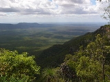
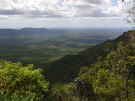
. The mountainous terrain of the tablelands provides a unique landscape featuring gorges, waterfalls and diverse vegetation.
It is the traditional home of the Ghungalu people, whose rock art can be found in the park.
Landforms
The Blackdown Tableland is a 600 m sandstoneSandstone
Sandstone is a sedimentary rock composed mainly of sand-sized minerals or rock grains.Most sandstone is composed of quartz and/or feldspar because these are the most common minerals in the Earth's crust. Like sand, sandstone may be any colour, but the most common colours are tan, brown, yellow,...
plateau rising abruptly from the plains below. Stony Creek and Mimosa Creek have developed gorges and waterfalls along their courses. It is located in the north east of the central Queensland sandstone belt.
The tablelands are positioned at the junction of the Shotover, Expedition
Expedition Range
Expedition Range is a mountain range within the Central Highlands sandstone region of Queensland, Australia. Robinson Creek cuts a 100 metres deep gorge through sandstone clifflines...
and Dawson Ranges. Evidence of folding
Fold (geology)
The term fold is used in geology when one or a stack of originally flat and planar surfaces, such as sedimentary strata, are bent or curved as a result of permanent deformation. Synsedimentary folds are those due to slumping of sedimentary material before it is lithified. Folds in rocks vary in...
is shown in the rises and depressions amongst the ranges.
Climate
The plateau has a more temperate, local climate than the surrounding plains, supporting open forests, heath, ferns, and a variety of plants and animals, several of which are not found anywhere else. Parts of the eastern tablelands have an average rainfall of 1,500 mm per year. Dense fog may shroud the plateau.Facilities
Camping is permitted at Munall campground. There are walking tracks leading to lookouts, heritage sites and creeks. Picnic facilities are available at Yaddamen Dhina lookout.Access
Access to the area was very limited until a road was constructed in 1969 by the Queensland Forest Department. Entrance to the park is via a turn-off 11 km west of Dingo along the Capricorn HighwayCapricorn Highway
The Capricorn Highway is located in Central Queensland, Australia, and links the city of Rockhampton with western Queensland. The highway is approximately 560 kilometres long, and joins the Landsborough Highway at Barcaldine...
.