
Emerald Isle, North Carolina
Encyclopedia
Emerald Isle is a town in Carteret County
, North Carolina
, United States
. It is part of the Crystal Coast
and is located entirely on the Bogue Banks
. The population was 3,488 at the 2000 census, but as many as 50,000 visitors inhabit the area during the summer season, filling up vacant rental properties that do not count toward official census results.
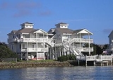
Today, the oceanfront is lined with both large and small homes. While there is a scattering of condominium
s, there are no oceanfront hotels, and Emerald Isle has maintained a family-oriented atmosphere.
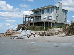
Recent beach renourishment
projects in North Carolina, including Emerald Isle, have been both praised and questioned.
 From about 1 AD to colonial times, Emerald Isle was home to Native Americans
. Later, the area was settled by a small number of whalers
and fishermen.
In the 1920s Henry Fort, who owned the Emerald Isle beaches and land surrounding them, hoped to open a large summer tourist attraction and ocean resort. Fort worked with developers, but the plans never materialized. After his death, his daughter Anita Maulick inherited Emerald Isle.
In 1951, seven individuals purchased the 12-mile stretch of island for $350,000 from Anita Maulick. Emerald Isle was sliced into 54 blocks of 1,000 feet, each going from ocean to sound. The partners drew from a hat for the ownership of blocks. Because they wanted Emerald Isle to be family-oriented, the owners limited commercial development and mobile homes to five blocks each.
In 1960 ferry
service began, and provided wider access to the Bogue Banks beaches of modern-day Emerald Isle.
In 1971 the Cameron Langston Bridge was opened to provide access from Cedar Point
to the western end of Bogue Banks and Emerald Isle. The bridge, spanning the Intracoastal Waterway
, offers a great view of the Bogue Sound
and Bogue Banks. The opening of the bridge increased island development.
Emerald Isle is a popular vacation spot and is also known for excellent fishing and a wealth of marine life. Notably its beaches are a favorite location for nesting sea turtles. http://www.emeraldisle-nc.org/turtles/default.htm
According to the United States Census Bureau
, the town has a total area of 5.3 mi2, of which 5.2 mi2 is land and 0.04 mi2 (0.57%) is water.
 As of the census
of 2000, there were 3,488 people, 1,644 households, and 1,088 families residing in the town. The population density
was 665.3 people per square mile (257.0/km²). There were 6,017 housing units at an average density of 1,147.8 per square mile (443.4/km²). The racial makeup of the town was 96.67% White, 0.80% African American, 0.46% Native American, 0.63% Asian, 0.03% Pacific Islander, 0.29% from other races
, and 1.12% from two or more races. Hispanic or Latino of any race were 1.63% of the population.
There were 1,644 households out of which 16.0% had children under the age of 18 living with them, 60.6% were married couples
living together, 4.0% had a female householder with no husband present, and 33.8% were non-families. 26.0% of all households were made up of individuals and 8.6% had someone living alone who was 65 years of age or older. The average household size was 2.12 and the average family size was 2.49.
In the town the population was spread out with 13.1% under the age of 18, 4.8% from 18 to 24, 24.0% from 25 to 44, 35.7% from 45 to 64, and 22.4% who were 65 years of age or older. The median age was 50 years. For every 100 females there were 105.5 males. For every 100 females age 18 and over, there were 105.8 males.
The median income for a household in the town was $53,274, and the median income for a family was $60,257. Males had a median income of $35,833 versus $28,417 for females. The per capita income
for the town was $31,316. About 2.1% of families and 2.7% of the population were below the poverty line, including none of those under age 18 and 5.0% of those age 65 or over.
Carteret County, North Carolina
Carteret County is a county located in the U.S. state of North Carolina. As of 2010, the population was 66,469. Its county seat is Beaufort. Most of the county is part of the Crystal Coast....
, North Carolina
North Carolina
North Carolina is a state located in the southeastern United States. The state borders South Carolina and Georgia to the south, Tennessee to the west and Virginia to the north. North Carolina contains 100 counties. Its capital is Raleigh, and its largest city is Charlotte...
, United States
United States
The United States of America is a federal constitutional republic comprising fifty states and a federal district...
. It is part of the Crystal Coast
Crystal Coast
The Crystal Coast is an 85-mile stretch of coastline in North Carolina that extends from the Cape Lookout National Seashore, which includes 56 miles of protected beaches, westward to the New River. It is also known as the Southern Outer Banks and is a popular area with tourists and second-home...
and is located entirely on the Bogue Banks
Bogue Banks
Bogue Banks form a barrier island off the mainland of North Carolina in Carteret County. The island, separated from the mainland by Bogue Sound, runs east to west, with the ocean beaches facing due south...
. The population was 3,488 at the 2000 census, but as many as 50,000 visitors inhabit the area during the summer season, filling up vacant rental properties that do not count toward official census results.
Today, the oceanfront is lined with both large and small homes. While there is a scattering of condominium
Condominium
A condominium, or condo, is the form of housing tenure and other real property where a specified part of a piece of real estate is individually owned while use of and access to common facilities in the piece such as hallways, heating system, elevators, exterior areas is executed under legal rights...
s, there are no oceanfront hotels, and Emerald Isle has maintained a family-oriented atmosphere.
Recent beach renourishment
Beach nourishment
Beach nourishment— also referred to as beach replenishment—describes a process by which sediment lost through longshore drift or erosion is replaced from sources outside of the eroding beach...
projects in North Carolina, including Emerald Isle, have been both praised and questioned.
History
Native Americans in the United States
Native Americans in the United States are the indigenous peoples in North America within the boundaries of the present-day continental United States, parts of Alaska, and the island state of Hawaii. They are composed of numerous, distinct tribes, states, and ethnic groups, many of which survive as...
. Later, the area was settled by a small number of whalers
Whaling
Whaling is the hunting of whales mainly for meat and oil. Its earliest forms date to at least 3000 BC. Various coastal communities have long histories of sustenance whaling and harvesting beached whales...
and fishermen.
In the 1920s Henry Fort, who owned the Emerald Isle beaches and land surrounding them, hoped to open a large summer tourist attraction and ocean resort. Fort worked with developers, but the plans never materialized. After his death, his daughter Anita Maulick inherited Emerald Isle.
In 1951, seven individuals purchased the 12-mile stretch of island for $350,000 from Anita Maulick. Emerald Isle was sliced into 54 blocks of 1,000 feet, each going from ocean to sound. The partners drew from a hat for the ownership of blocks. Because they wanted Emerald Isle to be family-oriented, the owners limited commercial development and mobile homes to five blocks each.
In 1960 ferry
Ferry
A ferry is a form of transportation, usually a boat, but sometimes a ship, used to carry primarily passengers, and sometimes vehicles and cargo as well, across a body of water. Most ferries operate on regular, frequent, return services...
service began, and provided wider access to the Bogue Banks beaches of modern-day Emerald Isle.
In 1971 the Cameron Langston Bridge was opened to provide access from Cedar Point
Cedar Point, North Carolina
Cedar Point is a town in Carteret County, North Carolina, United States. The population was 988 in 2007.-Geography:Cedar Point is located at ....
to the western end of Bogue Banks and Emerald Isle. The bridge, spanning the Intracoastal Waterway
Intracoastal Waterway
The Intracoastal Waterway is a 3,000-mile waterway along the Atlantic and Gulf coasts of the United States. Some lengths consist of natural inlets, salt-water rivers, bays, and sounds; others are artificial canals...
, offers a great view of the Bogue Sound
Bogue Sound
Bogue Sound is a medium-sized geographic sound in the state of North Carolina. It separates the Bogue Banks from mainland Carteret County. Morehead City's port is accessed via the Bogue Sound. Two bridges cross the sound: NC 58 on the B...
and Bogue Banks. The opening of the bridge increased island development.
Emerald Isle is a popular vacation spot and is also known for excellent fishing and a wealth of marine life. Notably its beaches are a favorite location for nesting sea turtles. http://www.emeraldisle-nc.org/turtles/default.htm
Geography
Emerald Isle is located at 34°40′1"N 77°0′49"W (34.666994, -77.013482).According to the United States Census Bureau
United States Census Bureau
The United States Census Bureau is the government agency that is responsible for the United States Census. It also gathers other national demographic and economic data...
, the town has a total area of 5.3 mi2, of which 5.2 mi2 is land and 0.04 mi2 (0.57%) is water.
Demographics
Census
A census is the procedure of systematically acquiring and recording information about the members of a given population. It is a regularly occurring and official count of a particular population. The term is used mostly in connection with national population and housing censuses; other common...
of 2000, there were 3,488 people, 1,644 households, and 1,088 families residing in the town. The population density
Population density
Population density is a measurement of population per unit area or unit volume. It is frequently applied to living organisms, and particularly to humans...
was 665.3 people per square mile (257.0/km²). There were 6,017 housing units at an average density of 1,147.8 per square mile (443.4/km²). The racial makeup of the town was 96.67% White, 0.80% African American, 0.46% Native American, 0.63% Asian, 0.03% Pacific Islander, 0.29% from other races
Race (United States Census)
Race and ethnicity in the United States Census, as defined by the Federal Office of Management and Budget and the United States Census Bureau, are self-identification data items in which residents choose the race or races with which they most closely identify, and indicate whether or not they are...
, and 1.12% from two or more races. Hispanic or Latino of any race were 1.63% of the population.
There were 1,644 households out of which 16.0% had children under the age of 18 living with them, 60.6% were married couples
Marriage
Marriage is a social union or legal contract between people that creates kinship. It is an institution in which interpersonal relationships, usually intimate and sexual, are acknowledged in a variety of ways, depending on the culture or subculture in which it is found...
living together, 4.0% had a female householder with no husband present, and 33.8% were non-families. 26.0% of all households were made up of individuals and 8.6% had someone living alone who was 65 years of age or older. The average household size was 2.12 and the average family size was 2.49.
In the town the population was spread out with 13.1% under the age of 18, 4.8% from 18 to 24, 24.0% from 25 to 44, 35.7% from 45 to 64, and 22.4% who were 65 years of age or older. The median age was 50 years. For every 100 females there were 105.5 males. For every 100 females age 18 and over, there were 105.8 males.
The median income for a household in the town was $53,274, and the median income for a family was $60,257. Males had a median income of $35,833 versus $28,417 for females. The per capita income
Per capita income
Per capita income or income per person is a measure of mean income within an economic aggregate, such as a country or city. It is calculated by taking a measure of all sources of income in the aggregate and dividing it by the total population...
for the town was $31,316. About 2.1% of families and 2.7% of the population were below the poverty line, including none of those under age 18 and 5.0% of those age 65 or over.