
Navigator
Encyclopedia
A navigator is the person on board a ship or aircraft responsible for its navigation
. The navigator's primary responsibility is to be aware of ship or aircraft position at all times. Responsibilities include planning the journey, advising the Captain
or aircraft Commander of estimated timing to destinations while en route, and ensuring hazards are avoided. The navigator is in charge of maintaining the aircraft or ship's nautical chart
s, nautical publications
, and navigational equipment, and generally has responsibility for meteorological equipment and communications.
In the world's air forces, modern navigators are frequently tasked with weapon systems employment and co-pilot type duties depending on the type, model and series of aircraft. In the U.S. Air Force, the aeronautical rating of Navigator has been augmented by addition of the Combat Systems Officer, while in the U.S. Navy and U.S. Marine Corps, those officers formerly called Navigators or Naval Aviation Observers have been known as Naval Flight Officer
s since the mid-1960s. USAF Navigators/Combat Systems Officers and USN/USMC Naval Flight Officers must be Basic Mission Qualified in their aircraft, or fly with an Instructor Navigator or Instructor NFO to provide the necessary training for their duties.
Shipborne navigators in the U.S. Navy are normally Surface Warfare Officer qualified with the exception of Naval Aviator
s and Naval Flight Officer
s assigned to Ship's Navigator billets aboard aircraft carrier
s and large deck amphibious assault ships and who have been qualified at a level equal to Surface Warfare Officers. U.S. Coast Guard officers that are shipboard navigators are normally Cutter qualified at a level analogous to the USN officers previously mentioned. Quartermaster
s are the Navigator's enlisted assistants and perform most of the technical navigation duties.
Aboard ships in the Merchant Marine and Merchant Navy, the Second Mate
is generally the (senior) Navigator.
With the advent of GPS, the effort required to accurately determine one's position has decreased by orders of magnitude, so the entire field has experienced a revolutionary transition since the 1990s with traditional navigation tasks being phased out. The U.S. Air Force and U.S. Navy, for instance, no longer teach aviators how to do celestial navigation
.
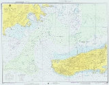
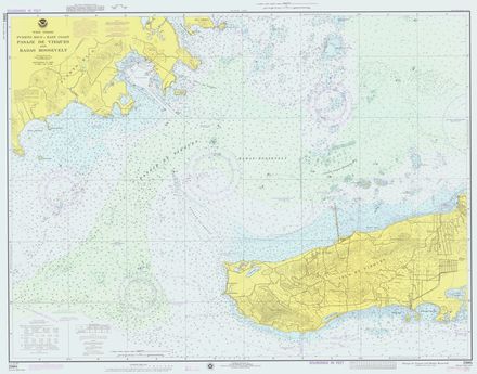 A naval ship's navigator is responsible for buying and maintaining its nautical charts. A nautical chart, or simply "chart", is a graphic representation of a maritime
or Flight region and adjacent coast
al regions. Depending on the scale
of the chart, it may show depths of water
and heights of land, natural features of the seabed, details of the coastline, navigational hazards, locations of natural and man-made aids to navigation
, information on tide
s and current
s, local details of the Earth's magnetic field
, restricted flying areas, and man-made structures such as harbor
s, buildings and bridge
s. Nautical charts are essential tools for marine navigation; many countries require vessels, especially commercial ships, to carry them. Nautical charting may take the form of charts printed on paper or computerised electronic navigational chart
s.
The nature of a waterway depicted by a chart changes regularly, and a mariner navigating on an old or uncorrected chart is courting disaster. Every producer of navigational charts also provides a system to inform mariners and aviators of changes that affect the chart. In the United States, chart corrections and notifications of new editions are provided by various governmental agencies by way of Notices to Airmen (NOTAMs), Notice to Mariners
, Local Notice to Mariners
, Summary of Corrections, and Broadcast Notice to Mariners. Radio broadcasts give advance notice of urgent corrections.
A convenient way to keep track of corrections is with a Chart and Publication Correction Record Card system. Using this system, the navigator does not immediately update every chart in the portfolio when a new Notice to Mariners arrives, instead creating a card for every chart and noting the correction on this card. When the time comes to use the chart, he pulls the chart and chart's card, and makes the indicated corrections on the chart. This system ensures that every chart is properly corrected prior to use. British Merchant Vessels receive weekly Notices to Mariners issued by the Admiralty
. When corrections are received all charts are corrected in the ship's folio and recorded in NP133A (Admiralty Chart Correction Log and Folio Index). This system ensures that all charts are corrected and up to date. In a deep sea vessel with a folio of over three thousand charts this can be a laborious and time consuming task for the [navigator].
Various and diverse methods exist for the correction of electronic navigational charts.
 The term Nautical publications is used in maritime circles to describe a set of publications, generally published by national governments, for use in safe navigation of ships, boats, and similar vessels.
The nature of waterways described by any given nautical publication changes regularly, and a mariner navigating by use of an old or uncorrected publication is courting disaster. Every producer of nautical publications also provides a system to inform mariners of changes that affect the chart. In the United States, corrections and notifications of new editions are provided by various governmental agencies by way of Notice to Mariners
, Local Notice to Mariners
, Summary of Corrections, and Broadcast Notice to Mariners. Radio broadcasts give advance notice of urgent corrections.
A convenient way to keep track of corrections is with a Chart and Publication Correction Record Card system. Using this system, the navigator does not immediately update every publication in the library when a new Notice to Mariners arrives, instead creating a card for every chart and noting the correction on this card. When the time comes to use the publication, he pulls the publication and its card, and makes the indicated corrections to the publication. This system ensures that every publication is properly corrected prior to use.
Various and diverse methods exist for the correction of electronic nautical publications.
s (or "mission plans" for USAF purposes). A mission/passage plan can be summarized as a comprehensive, step by step description of how the voyage is to proceed from berth to berth, including undocking, departure, the enroute portion of a voyage, approach, and mooring/arrival at the destination.
Before each voyage begins, the navigator should develop a detailed mental model of how the entire voyage will proceed. In the aviation community, this is known as "chair flying." This mental model includes charting courses, and forecasting weather, tides, and currents. It includes updating and checking nautical publications
, which could include Sailing Directions
and Coast Pilots
, and projecting the various future events including landfalls, narrow passages, and course changes that will transpire during the voyage. This mental model becomes the standard by which he will measure progress toward the goal of a safe and efficient voyage, and it is manifested in a written passage plan.
When working in a team environment, the passage/mission plan should be communicated to the navigation team in a pre-voyage conference (USAF term is "mission briefing") in order to ensure that all members of the team share the same mental model of the entire trip.
Passage planning procedures are specified in International Maritime Organization
Resolutions, in the laws of IMO signatory countries (for example, Title 33 of the U.S. Code of Federal Regulations
), and a number of professional books and USN/USAF publications. There are some fifty elements of a comprehensive passage plan depending on the size and type of vessel, each applicable according to the individual situation.
 A good passage plan will include a track line laid out upon the largest-scale charts available which cover the vessel's track. The navigator will draw and redraw the track line
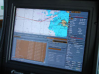
until it is safe, efficient, and in line with all applicable laws and regulations. When the track is finished, it is becoming common practice to also enter it into electronic navigation tools such as a Electronic Chart Display and Information System
, a chartplotter
, or a GPS unit.
Once the voyage has begun the progress of the vessel along its planned route must be monitored. This requires that the ship's position be determined, using standard methods including dead reckoning
, radar fixing, celestial navigation
, pilotage
, and electronic navigation
, to include usage of GPS and navigation computer equipment.
Passage planning software can greatly simplify the process and ensure that nothing important is overlooked. A good passage planning software program will include great circle waypoint/distance calculators, tide and tidal current predictors, celestial navigational calculators, consumables estimators for fuel, oil, water, and stores, and other useful applications.
Navigation
Navigation is the process of monitoring and controlling the movement of a craft or vehicle from one place to another. It is also the term of art used for the specialized knowledge used by navigators to perform navigation tasks...
. The navigator's primary responsibility is to be aware of ship or aircraft position at all times. Responsibilities include planning the journey, advising the Captain
Captain (nautical)
A sea captain is a licensed mariner in ultimate command of the vessel. The captain is responsible for its safe and efficient operation, including cargo operations, navigation, crew management and ensuring that the vessel complies with local and international laws, as well as company and flag...
or aircraft Commander of estimated timing to destinations while en route, and ensuring hazards are avoided. The navigator is in charge of maintaining the aircraft or ship's nautical chart
Nautical chart
A nautical chart is a graphic representation of a maritime area and adjacent coastal regions. Depending on the scale of the chart, it may show depths of water and heights of land , natural features of the seabed, details of the coastline, navigational hazards, locations of natural and man-made aids...
s, nautical publications
Nautical publications
Nautical publications is a technical term used in maritime circles describing a set of publications, generally published by national governments, for use in safe navigation of ships, boats, and similar vessels....
, and navigational equipment, and generally has responsibility for meteorological equipment and communications.
In the world's air forces, modern navigators are frequently tasked with weapon systems employment and co-pilot type duties depending on the type, model and series of aircraft. In the U.S. Air Force, the aeronautical rating of Navigator has been augmented by addition of the Combat Systems Officer, while in the U.S. Navy and U.S. Marine Corps, those officers formerly called Navigators or Naval Aviation Observers have been known as Naval Flight Officer
Naval Flight Officer
A Naval Flight Officer is an aeronautically designated commissioned officer in the United States Navy or United States Marine Corps that specializes in airborne weapons and sensor systems. NFOs are not pilots per se, but they may perform many "co-pilot" functions, depending on the type of aircraft...
s since the mid-1960s. USAF Navigators/Combat Systems Officers and USN/USMC Naval Flight Officers must be Basic Mission Qualified in their aircraft, or fly with an Instructor Navigator or Instructor NFO to provide the necessary training for their duties.
Shipborne navigators in the U.S. Navy are normally Surface Warfare Officer qualified with the exception of Naval Aviator
Naval Aviator
A United States Naval Aviator is a qualified pilot in the United States Navy, Marine Corps or Coast Guard.-Naming Conventions:Most Naval Aviators are Unrestricted Line Officers; however, a small number of Limited Duty Officers and Chief Warrant Officers are also trained as Naval Aviators.Until 1981...
s and Naval Flight Officer
Naval Flight Officer
A Naval Flight Officer is an aeronautically designated commissioned officer in the United States Navy or United States Marine Corps that specializes in airborne weapons and sensor systems. NFOs are not pilots per se, but they may perform many "co-pilot" functions, depending on the type of aircraft...
s assigned to Ship's Navigator billets aboard aircraft carrier
Aircraft carrier
An aircraft carrier is a warship designed with a primary mission of deploying and recovering aircraft, acting as a seagoing airbase. Aircraft carriers thus allow a naval force to project air power worldwide without having to depend on local bases for staging aircraft operations...
s and large deck amphibious assault ships and who have been qualified at a level equal to Surface Warfare Officers. U.S. Coast Guard officers that are shipboard navigators are normally Cutter qualified at a level analogous to the USN officers previously mentioned. Quartermaster
Quartermaster
Quartermaster refers to two different military occupations depending on if the assigned unit is land based or naval.In land armies, especially US units, it is a term referring to either an individual soldier or a unit who specializes in distributing supplies and provisions to troops. The senior...
s are the Navigator's enlisted assistants and perform most of the technical navigation duties.
Aboard ships in the Merchant Marine and Merchant Navy, the Second Mate
Second Mate
A second mate or second officer is a licensed member of the deck department of a merchant ship. The second mate is the third in command and a watchkeeping officer, customarily the ship's navigator. Other duties vary, but the second mate is often the medical officer and in charge of maintaining...
is generally the (senior) Navigator.
With the advent of GPS, the effort required to accurately determine one's position has decreased by orders of magnitude, so the entire field has experienced a revolutionary transition since the 1990s with traditional navigation tasks being phased out. The U.S. Air Force and U.S. Navy, for instance, no longer teach aviators how to do celestial navigation
Celestial navigation
Celestial navigation, also known as astronavigation, is a position fixing technique that has evolved over several thousand years to help sailors cross oceans without having to rely on estimated calculations, or dead reckoning, to know their position...
.
Nautical charts
Sea
A sea generally refers to a large body of salt water, but the term is used in other contexts as well. Most commonly, it means a large expanse of saline water connected with an ocean, and is commonly used as a synonym for ocean...
or Flight region and adjacent coast
Coast
A coastline or seashore is the area where land meets the sea or ocean. A precise line that can be called a coastline cannot be determined due to the dynamic nature of tides. The term "coastal zone" can be used instead, which is a spatial zone where interaction of the sea and land processes occurs...
al regions. Depending on the scale
Scale (map)
The scale of a map is defined as the ratio of a distance on the map to the corresponding distance on the ground.If the region of the map is small enough for the curvature of the Earth to be neglected, then the scale may be taken as a constant ratio over the whole map....
of the chart, it may show depths of water
Water
Water is a chemical substance with the chemical formula H2O. A water molecule contains one oxygen and two hydrogen atoms connected by covalent bonds. Water is a liquid at ambient conditions, but it often co-exists on Earth with its solid state, ice, and gaseous state . Water also exists in a...
and heights of land, natural features of the seabed, details of the coastline, navigational hazards, locations of natural and man-made aids to navigation
Navigation
Navigation is the process of monitoring and controlling the movement of a craft or vehicle from one place to another. It is also the term of art used for the specialized knowledge used by navigators to perform navigation tasks...
, information on tide
Tide
Tides are the rise and fall of sea levels caused by the combined effects of the gravitational forces exerted by the moon and the sun and the rotation of the Earth....
s and current
Ocean current
An ocean current is a continuous, directed movement of ocean water generated by the forces acting upon this mean flow, such as breaking waves, wind, Coriolis effect, cabbeling, temperature and salinity differences and tides caused by the gravitational pull of the Moon and the Sun...
s, local details of the Earth's magnetic field
Earth's magnetic field
Earth's magnetic field is the magnetic field that extends from the Earth's inner core to where it meets the solar wind, a stream of energetic particles emanating from the Sun...
, restricted flying areas, and man-made structures such as harbor
Harbor
A harbor or harbour , or haven, is a place where ships, boats, and barges can seek shelter from stormy weather, or else are stored for future use. Harbors can be natural or artificial...
s, buildings and bridge
Bridge
A bridge is a structure built to span physical obstacles such as a body of water, valley, or road, for the purpose of providing passage over the obstacle...
s. Nautical charts are essential tools for marine navigation; many countries require vessels, especially commercial ships, to carry them. Nautical charting may take the form of charts printed on paper or computerised electronic navigational chart
Electronic navigational chart
An electronic navigational chart is an official database created by a national hydrographic office for use with an Electronic Chart Display and Information System . An electronic chart must conform to standards stated in the International Hydrographic Organization Special Publication S-57 before...
s.
The nature of a waterway depicted by a chart changes regularly, and a mariner navigating on an old or uncorrected chart is courting disaster. Every producer of navigational charts also provides a system to inform mariners and aviators of changes that affect the chart. In the United States, chart corrections and notifications of new editions are provided by various governmental agencies by way of Notices to Airmen (NOTAMs), Notice to Mariners
Notice to Mariners
A notice to mariners advises mariners of important matters affecting navigational safety, including new hydrographic information, changes in channels and aids to navigation, and other important data.Over 60 countries which produce nautical charts also...
, Local Notice to Mariners
Local Notice to Mariners
A Local Notice to Mariners is an authoritative instruction issued by a designated official, typically the harbormaster.-United States:In the United States, notices are issued by each U.S. Coast Guard District to disseminate important information affecting navigational safety within that District...
, Summary of Corrections, and Broadcast Notice to Mariners. Radio broadcasts give advance notice of urgent corrections.
A convenient way to keep track of corrections is with a Chart and Publication Correction Record Card system. Using this system, the navigator does not immediately update every chart in the portfolio when a new Notice to Mariners arrives, instead creating a card for every chart and noting the correction on this card. When the time comes to use the chart, he pulls the chart and chart's card, and makes the indicated corrections on the chart. This system ensures that every chart is properly corrected prior to use. British Merchant Vessels receive weekly Notices to Mariners issued by the Admiralty
Admiralty
The Admiralty was formerly the authority in the Kingdom of England, and later in the United Kingdom, responsible for the command of the Royal Navy...
. When corrections are received all charts are corrected in the ship's folio and recorded in NP133A (Admiralty Chart Correction Log and Folio Index). This system ensures that all charts are corrected and up to date. In a deep sea vessel with a folio of over three thousand charts this can be a laborious and time consuming task for the [navigator].
Various and diverse methods exist for the correction of electronic navigational charts.
Nautical publications
The nature of waterways described by any given nautical publication changes regularly, and a mariner navigating by use of an old or uncorrected publication is courting disaster. Every producer of nautical publications also provides a system to inform mariners of changes that affect the chart. In the United States, corrections and notifications of new editions are provided by various governmental agencies by way of Notice to Mariners
Notice to Mariners
A notice to mariners advises mariners of important matters affecting navigational safety, including new hydrographic information, changes in channels and aids to navigation, and other important data.Over 60 countries which produce nautical charts also...
, Local Notice to Mariners
Local Notice to Mariners
A Local Notice to Mariners is an authoritative instruction issued by a designated official, typically the harbormaster.-United States:In the United States, notices are issued by each U.S. Coast Guard District to disseminate important information affecting navigational safety within that District...
, Summary of Corrections, and Broadcast Notice to Mariners. Radio broadcasts give advance notice of urgent corrections.
A convenient way to keep track of corrections is with a Chart and Publication Correction Record Card system. Using this system, the navigator does not immediately update every publication in the library when a new Notice to Mariners arrives, instead creating a card for every chart and noting the correction on this card. When the time comes to use the publication, he pulls the publication and its card, and makes the indicated corrections to the publication. This system ensures that every publication is properly corrected prior to use.
Various and diverse methods exist for the correction of electronic nautical publications.
Mission/Passage planning
The navigator focuses on creating the ship's passage planPassage planning
Passage planning or voyage planning is a procedure to develop a complete description of a vessel's voyage from start to finish. The plan includes leaving the dock and harbor area, the en-route portion of a voyage, approaching the destination, and mooring, the industry term for this is 'berth to...
s (or "mission plans" for USAF purposes). A mission/passage plan can be summarized as a comprehensive, step by step description of how the voyage is to proceed from berth to berth, including undocking, departure, the enroute portion of a voyage, approach, and mooring/arrival at the destination.
Before each voyage begins, the navigator should develop a detailed mental model of how the entire voyage will proceed. In the aviation community, this is known as "chair flying." This mental model includes charting courses, and forecasting weather, tides, and currents. It includes updating and checking nautical publications
Nautical publications
Nautical publications is a technical term used in maritime circles describing a set of publications, generally published by national governments, for use in safe navigation of ships, boats, and similar vessels....
, which could include Sailing Directions
Sailing Directions
Sailing Directions is a 42-volume American navigation publication published by the National Geospatial-Intelligence Agency . Sailing Directions consists of 37 Enroute volumes, 4 Planning Guide volumes, and 1 volume combining both types...
and Coast Pilots
Coast Pilots
United States Coast Pilots is a nine-volume American navigation publication distributed yearly by the National Oceanic and Atmospheric Administration's Office of Coast Survey. The purpose of the publication is to supplement nautical charts of United States of America waters. Information comes...
, and projecting the various future events including landfalls, narrow passages, and course changes that will transpire during the voyage. This mental model becomes the standard by which he will measure progress toward the goal of a safe and efficient voyage, and it is manifested in a written passage plan.
When working in a team environment, the passage/mission plan should be communicated to the navigation team in a pre-voyage conference (USAF term is "mission briefing") in order to ensure that all members of the team share the same mental model of the entire trip.
Passage planning procedures are specified in International Maritime Organization
International Maritime Organization
The International Maritime Organization , formerly known as the Inter-Governmental Maritime Consultative Organization , was established in Geneva in 1948, and came into force ten years later, meeting for the first time in 1959...
Resolutions, in the laws of IMO signatory countries (for example, Title 33 of the U.S. Code of Federal Regulations
Code of Federal Regulations
The Code of Federal Regulations is the codification of the general and permanent rules and regulations published in the Federal Register by the executive departments and agencies of the Federal Government of the United States.The CFR is published by the Office of the Federal Register, an agency...
), and a number of professional books and USN/USAF publications. There are some fifty elements of a comprehensive passage plan depending on the size and type of vessel, each applicable according to the individual situation.
Course (navigation)
In navigation, a vehicle's course is the angle that the intended path of the vehicle makes with a fixed reference object . Typically course is measured in degrees from 0° clockwise to 360° in compass convention . Course is customarily expressed in three digits, using preliminary zeros if needed,...
until it is safe, efficient, and in line with all applicable laws and regulations. When the track is finished, it is becoming common practice to also enter it into electronic navigation tools such as a Electronic Chart Display and Information System
Electronic Chart Display and Information System
An Electronic Chart Display and Information System is a computer-based navigation information system that complies with International Maritime Organization regulations and can be used as an alternative to paper nautical charts...
, a chartplotter
Chartplotter
A Chartplotter is a device used in marine navigation that integrates GPS data with an electronic navigational chart . The chartplotter displays the ENC along with the position, heading and speed of the ship, and may display additional information from radar, automatic information systems or other...
, or a GPS unit.
Once the voyage has begun the progress of the vessel along its planned route must be monitored. This requires that the ship's position be determined, using standard methods including dead reckoning
Dead reckoning
In navigation, dead reckoning is the process of calculating one's current position by using a previously determined position, or fix, and advancing that position based upon known or estimated speeds over elapsed time, and course...
, radar fixing, celestial navigation
Celestial navigation
Celestial navigation, also known as astronavigation, is a position fixing technique that has evolved over several thousand years to help sailors cross oceans without having to rely on estimated calculations, or dead reckoning, to know their position...
, pilotage
Aviator
An aviator is a person who flies an aircraft. The first recorded use of the term was in 1887, as a variation of 'aviation', from the Latin avis , coined in 1863 by G. de la Landelle in Aviation Ou Navigation Aérienne...
, and electronic navigation
Electronic navigation
Electronic navigation may refer to:*Global navigation satellite system, satellite navigation systems*Radio navigation, the application of radio frequencies to determining a position...
, to include usage of GPS and navigation computer equipment.
Passage planning software can greatly simplify the process and ensure that nothing important is overlooked. A good passage planning software program will include great circle waypoint/distance calculators, tide and tidal current predictors, celestial navigational calculators, consumables estimators for fuel, oil, water, and stores, and other useful applications.
Navigational equipment
The navigator is responsible for the maintenance of the ship's navigational equipment. U.S. Air Force navigators are responsible for troubleshooting problems of the navigation equipment while airborne, but the ground Maintenance personnel are ultimately responsible for repair and upkeep of that aircraft's navigation system.See also
- NavigationNavigationNavigation is the process of monitoring and controlling the movement of a craft or vehicle from one place to another. It is also the term of art used for the specialized knowledge used by navigators to perform navigation tasks...
- Officer of the DeckOfficer of the DeckOfficer of the deck is a position in the United States Navy and United States Coast Guard that confers certain authority and responsibility. The officer of the deck on a ship is the direct representative of the captain, having responsibility for the ship.-Overview:In port, the OOD is stationed on...
- Merchant Navy
- Nautical chartNautical chartA nautical chart is a graphic representation of a maritime area and adjacent coastal regions. Depending on the scale of the chart, it may show depths of water and heights of land , natural features of the seabed, details of the coastline, navigational hazards, locations of natural and man-made aids...
- Nautical publicationsNautical publicationsNautical publications is a technical term used in maritime circles describing a set of publications, generally published by national governments, for use in safe navigation of ships, boats, and similar vessels....
- Passage planningPassage planningPassage planning or voyage planning is a procedure to develop a complete description of a vessel's voyage from start to finish. The plan includes leaving the dock and harbor area, the en-route portion of a voyage, approaching the destination, and mooring, the industry term for this is 'berth to...
- United States Merchant MarineUnited States Merchant MarineThe United States Merchant Marine refers to the fleet of U.S. civilian-owned merchant vessels, operated by either the government or the private sector, that engage in commerce or transportation of goods and services in and out of the navigable waters of the United States. The Merchant Marine is...
- QuartermasterQuartermasterQuartermaster refers to two different military occupations depending on if the assigned unit is land based or naval.In land armies, especially US units, it is a term referring to either an individual soldier or a unit who specializes in distributing supplies and provisions to troops. The senior...
- Second MateSecond MateA second mate or second officer is a licensed member of the deck department of a merchant ship. The second mate is the third in command and a watchkeeping officer, customarily the ship's navigator. Other duties vary, but the second mate is often the medical officer and in charge of maintaining...
- Ship transportShip transportShip transport is watercraft carrying people or goods . Sea transport has been the largest carrier of freight throughout recorded history. Although the importance of sea travel for passengers has decreased due to aviation, it is effective for short trips and pleasure cruises...