
.gif)
Blackwater River (Chowan River)
Encyclopedia
The Blackwater River of southeastern Virginia
flows from its source near the city of Petersburg, Virginia
for about 105 miles (170 km) through the Inner Coastal Plain region of Virginia (part of the Atlantic Coastal Plain
). The Blackwater joins the Nottoway River
to form the Chowan River
, which empties into Albemarle Sound
. The Blackwater-Nottoway confluence forms the boundary between Virginia and North Carolina
.
. Its water is clear, dark, slightly acidic, and tannin stained. Its drainage basin
contains many swamp
s. The river's flood plain is mostly forested and swampy, including bald cypress and tupelo
swamp forests. The upper Blackwater River is called Blackwater Swamp. In this region of Virginia, many streams are called "swamps" but still function like streams in being long and linear, with water moving from one end to the other and laid out in a normal stream tributary network. In contrast, some of the region's wetlands are not streams, such as the bog-like pocosin
s found on the higher land between swamp-stream drainages.
The Blackwater River was a transportation route in the 17th and 18th centuries, connecting the Chesapeake Bay
settlements with the Albemarle Settlements
. It was one of the few rivers of colonial Virginia that did not empty into Chesapeake Bay yet lay close to the colony's oldest settlements on the James River
. Settlements in the Blackwater's drainage basin were founded very early in Virginia's history. As a result, the Blackwater River became one of the early migration routes southward from the James River into the region then called Southside Virginia, and beyond into the Albemarle District of Carolina
(later North Carolina
). Today's usual definition of Southside
differs somewhat from that of colonial times.
in several swamps. It flows southeast through Prince George County
, where it is called Blackwater Swamp. It then forms part of the border between Surry County
and Sussex County
, where its name becomes Blackwater River. It collects tributaries called Warwick Swamp, Otterdam Swamp, Coppahaunk Swamp, and Cypress Swamp. In southern Surry County, the Blackwater River turns south and forms the border between Isle of Wight County
and Southampton County
. It collects tributaries called Terrapin Swamp, Antioch Swamp, Seacock Swamp, Corrowaugh Swamp, and Kingsale Swamp.
The city of Franklin, Virginia
, lies on its west bank at the river's head of navigation. While canoes and other small boats plied the Blackwater upstream of Franklin in colonial times (and still do today), in the steamboat era, navigation was restricted to the river downstream of Franklin.
South of Franklin, the Blackwater River forms the border between Southampton County and Suffolk, Virginia
.
About nine miles (14 km) south of Franklin, on the border between Virginia and North Carolina, the Blackwater River is joined by the Nottoway River, forming the Chowan River, which continues south to Albemarle Sound. The boundary between Virginia and North Carolina runs west from the Atlantic Ocean, striking the Blackwater River about a half mile (1 km) north of the confluence with the Nottoway River. From there the state line follows the Blackwater River south to the confluence, then continues west.
The watershed
of the Blackwater River contains a portion of three cities and five counties of Virginia: the cities of Franklin, Petersburg, and Suffolk, and the counties of Isle of Wight, Prince George, Southampton, Surry, and Sussex.
— its waters are clear, dark, acidic, low in nutrients, and tannin stained. Several environmental factors cause the blackwater condition. The many forested wetlands along the river include Streamhead Pocosins and Bald Cypress and Tupelo Swamps.
The Blackwater is known for its pocosins, including the rare type called streamhead pocosin. The only two streamhead pocosins known in Virginia are on the Blackwater River.
Bald Cypress and Tupelo Swamps occur along many streams of the Atlantic Coastal Plain
. Most were logged, thus old-growth examples are rare. The Blackwater River Preserve protects one of the oldest bald cypress and tupelo swamp forests in the South
, with trees up to 800 years old. The largest known water tupelo in the United States, according to the National Register of Big Trees, is in Isle of Wight County. It stands 95 feet (29 m) tall with a circumference of 406 inches (10.3 m). Another stand of old-growth bald cypress and tupelo forest, known as Dendron Swamp, was recently designated a Natural Area Preserve by the Virginia Department of Conservation of Recreation.
Another rare type of forest found along the Blackwater River is a type called Longleaf Pine and Mixed Pine Flatwoods. The forests were once common but today are restricted to a few small sites on the east side of the Blackwater River. Near the town of Zuni, Virginia
, one stand is protected by the Blackwater Ecological Preserve.
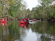
The many old forests and wetlands along the Blackwater River have made it popular for recreational canoeing.
The dark, tannin stained waters of the Blackwater River host runs of striped bass, river herring (alewives and blueback), American and hickory shad in the spring. Angling for redbreast sunfish ("red throats" or "red robins") is also quite good in the spring. The river also hosts largemouth bass, bluegill, crappie, flier, and chain pickerel populations. Bowfin and gar are common in the lower main stem. Angling for bowfin provides a great opportunity to catch many hard-fighting fish in a short amount of time. The possibility also exists to land a trophy bowfin over ten pounds.
 Recreational opportunities are limited to some bridge crossings, state boat ramps, and canoe access areas. No permits are required.
Boat ramps can be found at Routes 611 (Joyner's Bridge Rd) and 603 off Route 258 in Isle of Wight County.
A new double-lane boat ramp with paved parking will be open in the City of Franklin in the spring of 2007.
Canoe access can be found off of Rt. 619 (Burdette), Rt. 189 (S. Quay), and Rt. 620 (Broadwater Br.), but beware of vehicle parking restrictions. If you are putting in at Rt. 620 speak with landowner across the street.
and the Powhatan
confederation, a peace treaty was agreed to by the leaders of the two sides (Governor William Berkeley and Chief Necotowance). The treaty set the boundary between Virginia and Indian
lands at the lower Blackwater River (or Blackwater Swamp) up to its head at "Yapim" (modern Franklin), and thence in a directly straight line to the "Monacan town" (Mowhemencho, at the eastern tip of Powhatan County). Native Americans were only allowed to cross this line at the newly-built Fort Henry on the Appomattox, where Petersburg
now is, and they had to display a special badge, without which they could be killed on the spot, or after 1662, arrested.
By the late 17th century, some settlers from Virginia were crossing the Blackwater-Ft. Henry-Monacan town boundary, and settling in territory of Indian tribes such as the Appomattoc
and the Nottoway
. The government of Virginia repeatedly ordered such people to return northeast of this line, and would not allow the land beyond to be surveyed for land grant
s. In 1685, the House of Burgesses
asked Governor Howard for permission to grant some land south of the Blackwater River. The governor denied the request.
According to a petition by the colonial government of Virginia made to the King, dated May 1, 1688, the Tributary Indians, who still legally owned the land west of the line, allegedly asked for settlers to move into their territory. The reason for the request was said to be fear of invasion by larger, non-Tributary tribes, in light of their own dwindling numbers, besides that "Such large Tracts of Land are of noe benefit nor use unto them". However, King William and Queen Mary wanted the moratorium on patents extended, and in 1691, another order was given demanding all settlers south of the river to return north. By 1706, the Blackwater boundary law was revoked and settlements south of the river or west of the line became legal.
Transportation in early colonial Virginia was usually done by water. The many wide estuaries and wetland
s made land transport difficult, especially when moving goods. Migration and settlement patterns thus tended to follow the rivers, most of which flowed from the west and emptied into Chesapeake Bay
. The Blackwater River was an exception. It flowed south to Albemarle Sound. The Blackwater's headwaters were close to the main settlements along the James River (some within three miles). By the early 18th century, Virginians were living along the upper Blackwater River and using the river for travel and transportation. The political authority of Virginia was centered on Chesapeake Bay. Most of the other rivers used for travel in Virginia at the time emptied into the bay, which helped Virginia's government control the colony's affairs. The settlers using the Blackwater River, however, were drawn away from Chesapeake Bay to the relatively lawless settlements of Albemarle Bay. This played a role in the emerging "southside" society, as the region "south of the James River" became known. As early as 1713 a place called South Quay six and a half miles downriver from Franklin was becoming an important trade port. By 1777 South Quay was known as the leading interior port to the Tidewater area. Large warehouses were storing tobacco, pork and other goods for export and import. The South Quay venture eventually also became a shipyard and built two ships, the Caswell and the Washington, that helped defend the coast from the British fleet in 1777/78. On July 16, 1781, English Lieutenant Colonel Dundas was dispatched by Cornwallis to destroy South Quay, ending the commercial activity of what today is called Old South Quay.
During the American Civil War
, the Blackwater River was for a time the dividing line between Union
-occupied territory and Confederate Virginia. The boundary was not well defended, allowing thousands of "contrabands" (as the slaves were called during the war) the chance to flee east out of Southampton County, across the Blackwater River and into freedom.
, when heavy rainfall occurs throughout the area, severe flooding occasionally occurs at several points as the large volume of water flows downstream. Critical points of such flooding have been near Zuni
along U.S. Route 460
, and in the independent city
of Franklin
, which borders Southampton County and Isle of Wight County. Unlike the marshy areas upstream, at these points the river's channel is limited, and flood stages can be reached very quickly. This occurred during Hurricane Floyd
in 1999, and again in October 2006, after an unnamed Nor'-Easter storm dumped 10 inches (25 cm) of rain on the region.
Virginia
The Commonwealth of Virginia , is a U.S. state on the Atlantic Coast of the Southern United States. Virginia is nicknamed the "Old Dominion" and sometimes the "Mother of Presidents" after the eight U.S. presidents born there...
flows from its source near the city of Petersburg, Virginia
Petersburg, Virginia
Petersburg is an independent city in Virginia, United States located on the Appomattox River and south of the state capital city of Richmond. The city's population was 32,420 as of 2010, predominantly of African-American ethnicity...
for about 105 miles (170 km) through the Inner Coastal Plain region of Virginia (part of the Atlantic Coastal Plain
Atlantic Coastal Plain
The Atlantic coastal plain has both low elevation and low relief, but it is also a relatively flat landform extending from the New York Bight southward to a Georgia/Florida section of the Eastern Continental Divide, which demarcates the plain from the ACF River Basin in the Gulf Coastal Plain to...
). The Blackwater joins the Nottoway River
Nottoway River
The Nottoway River is in southern Virginia and northeastern North Carolina. It is part of the Chowan River system, which flows into Albemarle Sound in North Carolina.-Cities and towns:Cities and towns along the river include:* Courtland, Virginia...
to form the Chowan River
Chowan River
The Chowan River is a blackwater river formed with the merging of Virginia's Blackwater and Nottoway rivers near the stateline between Virginia and North Carolina. According to the USGS a variant name is Choan River....
, which empties into Albemarle Sound
Albemarle Sound
Albemarle Sound is a large estuary on the coast of North Carolina in the United States located at the confluence of a group of rivers, including the Chowan and Roanoke. It is separated from the Atlantic Ocean by the Outer Banks, a long barrier peninsula upon which the town of Kitty Hawk is located,...
. The Blackwater-Nottoway confluence forms the boundary between Virginia and North Carolina
North Carolina
North Carolina is a state located in the southeastern United States. The state borders South Carolina and Georgia to the south, Tennessee to the west and Virginia to the north. North Carolina contains 100 counties. Its capital is Raleigh, and its largest city is Charlotte...
.
Overview
The Blackwater River is a true blackwater riverBlackwater river
A blackwater river is a river with a deep, slow-moving channel that flows through forested swamps and wetlands. As vegetation decays in the water, tannins are leached out, resulting in transparent, acidic water that is darkly stained, resembling tea or coffee. Most major blackwater rivers are in...
. Its water is clear, dark, slightly acidic, and tannin stained. Its drainage basin
Drainage basin
A drainage basin is an extent or an area of land where surface water from rain and melting snow or ice converges to a single point, usually the exit of the basin, where the waters join another waterbody, such as a river, lake, reservoir, estuary, wetland, sea, or ocean...
contains many swamp
Swamp
A swamp is a wetland with some flooding of large areas of land by shallow bodies of water. A swamp generally has a large number of hammocks, or dry-land protrusions, covered by aquatic vegetation, or vegetation that tolerates periodical inundation. The two main types of swamp are "true" or swamp...
s. The river's flood plain is mostly forested and swampy, including bald cypress and tupelo
Tupelo
The tupelo , black gum, or pepperidge tree, genus Nyssa , is a small genus of about 9 to 11 species of trees with alternate, simple leaves...
swamp forests. The upper Blackwater River is called Blackwater Swamp. In this region of Virginia, many streams are called "swamps" but still function like streams in being long and linear, with water moving from one end to the other and laid out in a normal stream tributary network. In contrast, some of the region's wetlands are not streams, such as the bog-like pocosin
Pocosin
Pocosin is a term for a type of palustrine wetland with deep, acidic, sandy, peat soils. Groundwater saturates the soil except during brief seasonal dry spells and during prolonged droughts...
s found on the higher land between swamp-stream drainages.
The Blackwater River was a transportation route in the 17th and 18th centuries, connecting the Chesapeake Bay
Chesapeake Bay
The Chesapeake Bay is the largest estuary in the United States. It lies off the Atlantic Ocean, surrounded by Maryland and Virginia. The Chesapeake Bay's drainage basin covers in the District of Columbia and parts of six states: New York, Pennsylvania, Delaware, Maryland, Virginia, and West...
settlements with the Albemarle Settlements
Albemarle Settlements
The Albemarle Settlements were the first permanent English settlements in what is now North Carolina, founded in the Albemarle Sound and Roanoke River regions, beginning about the middle of the 17th century. The settlers were mainly Virginians migrating south...
. It was one of the few rivers of colonial Virginia that did not empty into Chesapeake Bay yet lay close to the colony's oldest settlements on the James River
James River (Virginia)
The James River is a river in the U.S. state of Virginia. It is long, extending to if one includes the Jackson River, the longer of its two source tributaries. The James River drains a catchment comprising . The watershed includes about 4% open water and an area with a population of 2.5 million...
. Settlements in the Blackwater's drainage basin were founded very early in Virginia's history. As a result, the Blackwater River became one of the early migration routes southward from the James River into the region then called Southside Virginia, and beyond into the Albemarle District of Carolina
Province of Carolina
The Province of Carolina, originally chartered in 1629, was an English and later British colony of North America. Because the original Heath charter was unrealized and was ruled invalid, a new charter was issued to a group of eight English noblemen, the Lords Proprietors, in 1663...
(later North Carolina
North Carolina
North Carolina is a state located in the southeastern United States. The state borders South Carolina and Georgia to the south, Tennessee to the west and Virginia to the north. North Carolina contains 100 counties. Its capital is Raleigh, and its largest city is Charlotte...
). Today's usual definition of Southside
Southside (Virginia)
Traditionally, the term Southside refers to the portion of Virginia east of the Blue Ridge Mountains and south of the James River, the geographic feature from which the term derives its name....
differs somewhat from that of colonial times.
Course
The Blackwater River originates just south of the city of Petersburg, VirginiaPetersburg, Virginia
Petersburg is an independent city in Virginia, United States located on the Appomattox River and south of the state capital city of Richmond. The city's population was 32,420 as of 2010, predominantly of African-American ethnicity...
in several swamps. It flows southeast through Prince George County
Prince George County, Virginia
As of the census of 2000, there were 33,047 people, 10,159 households, and 8,096 families residing in the county. The population density was 124 people per square mile . There were 10,726 housing units at an average density of 40 per square mile...
, where it is called Blackwater Swamp. It then forms part of the border between Surry County
Surry County, Virginia
As of the census of 2010, there were 7,058 people, 2,619 households, and 1,917 families residing in the county. The population density was 24 people per square mile . There were 3,294 housing units at an average density of 12 per square mile...
and Sussex County
Sussex County, Virginia
As of the census of 2000, there were 12,504 people, 4,126 households, and 2,809 families residing in the county. The population density was 26 people per square mile . There were 4,653 housing units at an average density of 10 per square mile...
, where its name becomes Blackwater River. It collects tributaries called Warwick Swamp, Otterdam Swamp, Coppahaunk Swamp, and Cypress Swamp. In southern Surry County, the Blackwater River turns south and forms the border between Isle of Wight County
Isle of Wight County, Virginia
As of the census of 2010, there were 35,270 people, 11,319 households, and 8,670 families residing in the county. The population density was 94 people per square mile . There were 12,066 housing units at an average density of 38 per square mile...
and Southampton County
Southampton County, Virginia
As of the census of 2010, there were 18,570 people, 6,279 households, and 4,502 families residing in the county. The population density was 29 people per square mile . There were 7,058 housing units at an average density of 12 per square mile...
. It collects tributaries called Terrapin Swamp, Antioch Swamp, Seacock Swamp, Corrowaugh Swamp, and Kingsale Swamp.
The city of Franklin, Virginia
Franklin, Virginia
Franklin is an independent city in Virginia. The Bureau of Economic Analysis combines the city of Franklin with Southampton county for statistical purposes. The population was 8,582 in 2010.-History:...
, lies on its west bank at the river's head of navigation. While canoes and other small boats plied the Blackwater upstream of Franklin in colonial times (and still do today), in the steamboat era, navigation was restricted to the river downstream of Franklin.
South of Franklin, the Blackwater River forms the border between Southampton County and Suffolk, Virginia
Suffolk, Virginia
Suffolk is the largest city by area in Virginia, United States, and is located in the Hampton Roads metropolitan area. As of the 2010 census, the city had a total population of 84,585. Its median household income was $57,546.-History:...
.
About nine miles (14 km) south of Franklin, on the border between Virginia and North Carolina, the Blackwater River is joined by the Nottoway River, forming the Chowan River, which continues south to Albemarle Sound. The boundary between Virginia and North Carolina runs west from the Atlantic Ocean, striking the Blackwater River about a half mile (1 km) north of the confluence with the Nottoway River. From there the state line follows the Blackwater River south to the confluence, then continues west.
The watershed
Drainage basin
A drainage basin is an extent or an area of land where surface water from rain and melting snow or ice converges to a single point, usually the exit of the basin, where the waters join another waterbody, such as a river, lake, reservoir, estuary, wetland, sea, or ocean...
of the Blackwater River contains a portion of three cities and five counties of Virginia: the cities of Franklin, Petersburg, and Suffolk, and the counties of Isle of Wight, Prince George, Southampton, Surry, and Sussex.
Natural history
The Blackwater River is, as its name implies, a blackwater riverBlackwater river
A blackwater river is a river with a deep, slow-moving channel that flows through forested swamps and wetlands. As vegetation decays in the water, tannins are leached out, resulting in transparent, acidic water that is darkly stained, resembling tea or coffee. Most major blackwater rivers are in...
— its waters are clear, dark, acidic, low in nutrients, and tannin stained. Several environmental factors cause the blackwater condition. The many forested wetlands along the river include Streamhead Pocosins and Bald Cypress and Tupelo Swamps.
The Blackwater is known for its pocosins, including the rare type called streamhead pocosin. The only two streamhead pocosins known in Virginia are on the Blackwater River.
Bald Cypress and Tupelo Swamps occur along many streams of the Atlantic Coastal Plain
Atlantic Coastal Plain
The Atlantic coastal plain has both low elevation and low relief, but it is also a relatively flat landform extending from the New York Bight southward to a Georgia/Florida section of the Eastern Continental Divide, which demarcates the plain from the ACF River Basin in the Gulf Coastal Plain to...
. Most were logged, thus old-growth examples are rare. The Blackwater River Preserve protects one of the oldest bald cypress and tupelo swamp forests in the South
Southern United States
The Southern United States—commonly referred to as the American South, Dixie, or simply the South—constitutes a large distinctive area in the southeastern and south-central United States...
, with trees up to 800 years old. The largest known water tupelo in the United States, according to the National Register of Big Trees, is in Isle of Wight County. It stands 95 feet (29 m) tall with a circumference of 406 inches (10.3 m). Another stand of old-growth bald cypress and tupelo forest, known as Dendron Swamp, was recently designated a Natural Area Preserve by the Virginia Department of Conservation of Recreation.
Another rare type of forest found along the Blackwater River is a type called Longleaf Pine and Mixed Pine Flatwoods. The forests were once common but today are restricted to a few small sites on the east side of the Blackwater River. Near the town of Zuni, Virginia
Zuni, Virginia
Zuni is an unincorporated community in Isle of Wight County in the Hampton Roads region of southeastern Virginia in the United States.Zuni is home to a dentist's office, a Ruritan club, a general store, a gas station, and two churches and is served by its own Post Office. The name is properly...
, one stand is protected by the Blackwater Ecological Preserve.
The many old forests and wetlands along the Blackwater River have made it popular for recreational canoeing.
Fishing
The Blackwater originates as a coastal plain swamp in Prince George County. It flows east through braided channels of bald cypress and tupelo in Surry County. The river then turns south into Southampton County where several boat ramps are accessible for anglers, hunters and boaters alike. The Blackwater then joins with the Nottoway to form the Chowan at the Virginia-North Carolina state line. On any one trip you can see whitetail deer, numerous waterfowl, raccoons, squirrels and many unique reptile and amphibian species, not to mention a healthy fish population swimming under the water's surface.The dark, tannin stained waters of the Blackwater River host runs of striped bass, river herring (alewives and blueback), American and hickory shad in the spring. Angling for redbreast sunfish ("red throats" or "red robins") is also quite good in the spring. The river also hosts largemouth bass, bluegill, crappie, flier, and chain pickerel populations. Bowfin and gar are common in the lower main stem. Angling for bowfin provides a great opportunity to catch many hard-fighting fish in a short amount of time. The possibility also exists to land a trophy bowfin over ten pounds.
Canoeing and Kayaking
Boat ramps can be found at Routes 611 (Joyner's Bridge Rd) and 603 off Route 258 in Isle of Wight County.
A new double-lane boat ramp with paved parking will be open in the City of Franklin in the spring of 2007.
Canoe access can be found off of Rt. 619 (Burdette), Rt. 189 (S. Quay), and Rt. 620 (Broadwater Br.), but beware of vehicle parking restrictions. If you are putting in at Rt. 620 speak with landowner across the street.
Colonial and later history
In 1646, after two years of war between the Virginia colonyColony and Dominion of Virginia
The Colony of Virginia was the English colony in North America that existed briefly during the 16th century, and then continuously from 1607 until the American Revolution...
and the Powhatan
Powhatan
The Powhatan is the name of a Virginia Indian confederation of tribes. It is estimated that there were about 14,000–21,000 of these native Powhatan people in eastern Virginia when the English settled Jamestown in 1607...
confederation, a peace treaty was agreed to by the leaders of the two sides (Governor William Berkeley and Chief Necotowance). The treaty set the boundary between Virginia and Indian
Native Americans in the United States
Native Americans in the United States are the indigenous peoples in North America within the boundaries of the present-day continental United States, parts of Alaska, and the island state of Hawaii. They are composed of numerous, distinct tribes, states, and ethnic groups, many of which survive as...
lands at the lower Blackwater River (or Blackwater Swamp) up to its head at "Yapim" (modern Franklin), and thence in a directly straight line to the "Monacan town" (Mowhemencho, at the eastern tip of Powhatan County). Native Americans were only allowed to cross this line at the newly-built Fort Henry on the Appomattox, where Petersburg
Petersburg, Virginia
Petersburg is an independent city in Virginia, United States located on the Appomattox River and south of the state capital city of Richmond. The city's population was 32,420 as of 2010, predominantly of African-American ethnicity...
now is, and they had to display a special badge, without which they could be killed on the spot, or after 1662, arrested.
By the late 17th century, some settlers from Virginia were crossing the Blackwater-Ft. Henry-Monacan town boundary, and settling in territory of Indian tribes such as the Appomattoc
Appomattoc
The Appomattoc were a historic tribe of Virginia Indians speaking an Algonquian language, and residing along the lower Appomattox River, in the area of what is now Petersburg, Colonial Heights, Chesterfield and Dinwiddie Counties in present-day southeast Virginia.The Appomattoc were affiliated...
and the Nottoway
Nottoway
- Geographic Regions :* Nottoway River, a river in Virginia* Nottoway County, a county of Virginia* Nottoway, Virginia, an unincorporated community- Namesakes :* USS Nottoway, renamed , a harbour tug of the United States Navy between 1898–1946....
. The government of Virginia repeatedly ordered such people to return northeast of this line, and would not allow the land beyond to be surveyed for land grant
Land grant
A land grant is a gift of real estate – land or its privileges – made by a government or other authority as a reward for services to an individual, especially in return for military service...
s. In 1685, the House of Burgesses
House of Burgesses
The House of Burgesses was the first assembly of elected representatives of English colonists in North America. The House was established by the Virginia Company, who created the body as part of an effort to encourage English craftsmen to settle in North America...
asked Governor Howard for permission to grant some land south of the Blackwater River. The governor denied the request.
According to a petition by the colonial government of Virginia made to the King, dated May 1, 1688, the Tributary Indians, who still legally owned the land west of the line, allegedly asked for settlers to move into their territory. The reason for the request was said to be fear of invasion by larger, non-Tributary tribes, in light of their own dwindling numbers, besides that "Such large Tracts of Land are of noe benefit nor use unto them". However, King William and Queen Mary wanted the moratorium on patents extended, and in 1691, another order was given demanding all settlers south of the river to return north. By 1706, the Blackwater boundary law was revoked and settlements south of the river or west of the line became legal.
Transportation in early colonial Virginia was usually done by water. The many wide estuaries and wetland
Wetland
A wetland is an area of land whose soil is saturated with water either permanently or seasonally. Wetlands are categorised by their characteristic vegetation, which is adapted to these unique soil conditions....
s made land transport difficult, especially when moving goods. Migration and settlement patterns thus tended to follow the rivers, most of which flowed from the west and emptied into Chesapeake Bay
Chesapeake Bay
The Chesapeake Bay is the largest estuary in the United States. It lies off the Atlantic Ocean, surrounded by Maryland and Virginia. The Chesapeake Bay's drainage basin covers in the District of Columbia and parts of six states: New York, Pennsylvania, Delaware, Maryland, Virginia, and West...
. The Blackwater River was an exception. It flowed south to Albemarle Sound. The Blackwater's headwaters were close to the main settlements along the James River (some within three miles). By the early 18th century, Virginians were living along the upper Blackwater River and using the river for travel and transportation. The political authority of Virginia was centered on Chesapeake Bay. Most of the other rivers used for travel in Virginia at the time emptied into the bay, which helped Virginia's government control the colony's affairs. The settlers using the Blackwater River, however, were drawn away from Chesapeake Bay to the relatively lawless settlements of Albemarle Bay. This played a role in the emerging "southside" society, as the region "south of the James River" became known. As early as 1713 a place called South Quay six and a half miles downriver from Franklin was becoming an important trade port. By 1777 South Quay was known as the leading interior port to the Tidewater area. Large warehouses were storing tobacco, pork and other goods for export and import. The South Quay venture eventually also became a shipyard and built two ships, the Caswell and the Washington, that helped defend the coast from the British fleet in 1777/78. On July 16, 1781, English Lieutenant Colonel Dundas was dispatched by Cornwallis to destroy South Quay, ending the commercial activity of what today is called Old South Quay.
During the American Civil War
American Civil War
The American Civil War was a civil war fought in the United States of America. In response to the election of Abraham Lincoln as President of the United States, 11 southern slave states declared their secession from the United States and formed the Confederate States of America ; the other 25...
, the Blackwater River was for a time the dividing line between Union
Union (American Civil War)
During the American Civil War, the Union was a name used to refer to the federal government of the United States, which was supported by the twenty free states and five border slave states. It was opposed by 11 southern slave states that had declared a secession to join together to form the...
-occupied territory and Confederate Virginia. The boundary was not well defended, allowing thousands of "contrabands" (as the slaves were called during the war) the chance to flee east out of Southampton County, across the Blackwater River and into freedom.
Flooding
Because the Blackwater River drains a large area of southern Virginia east of the fall lineFall line
A fall line is a geomorphologic unconformity between an upland region of relatively hard crystalline basement rock and a coastal plain of softer sedimentary rock. A fall line is typically prominent when crossed by a river, for there will often be rapids or waterfalls...
, when heavy rainfall occurs throughout the area, severe flooding occasionally occurs at several points as the large volume of water flows downstream. Critical points of such flooding have been near Zuni
Zuni, Virginia
Zuni is an unincorporated community in Isle of Wight County in the Hampton Roads region of southeastern Virginia in the United States.Zuni is home to a dentist's office, a Ruritan club, a general store, a gas station, and two churches and is served by its own Post Office. The name is properly...
along U.S. Route 460
U.S. Route 460
U.S. Route 460 is a spur of U.S. Route 60. It currently runs for 655 miles from Norfolk, Virginia at U.S. Route 60 at Ocean View to Frankfort, Kentucky at U.S. Route 60. It passes through the states of Virginia, West Virginia, and Kentucky...
, and in the independent city
Independent city
An independent city is a city that does not form part of another general-purpose local government entity. These type of cities should not be confused with city-states , which are fully sovereign cities that are not part of any other sovereign state.-Historical precursors:In the Holy Roman Empire,...
of Franklin
Franklin, Virginia
Franklin is an independent city in Virginia. The Bureau of Economic Analysis combines the city of Franklin with Southampton county for statistical purposes. The population was 8,582 in 2010.-History:...
, which borders Southampton County and Isle of Wight County. Unlike the marshy areas upstream, at these points the river's channel is limited, and flood stages can be reached very quickly. This occurred during Hurricane Floyd
Hurricane Floyd
Hurricane Floyd was the sixth named storm, fourth hurricane, and third major hurricane in the 1999 Atlantic hurricane season. Floyd triggered the third largest evacuation in US history when 2.6 million coastal residents of five states were ordered from their homes as it approached...
in 1999, and again in October 2006, after an unnamed Nor'-Easter storm dumped 10 inches (25 cm) of rain on the region.
External links
- http://www.blackwaternottoway.com
- http://www.nature.org/pressroom/ip/about/virginia.html
- http://www.nature.org/wherewework/northamerica/states/virginia/preserves/
- http://www.dcr.state.va.us/dnh/
- http://www.dcr.virginia.gov/dnh/dendron.htm
- http://www.cecer.army.mil/techreports/Tra_peat.wpd/Tra_peat-04.htm#P199_14402
- http://sciway3.net/clark/gill/vaheadright.html
- http://www.virginiaplaces.org/regions/14southside.html
- http://web.ukonline.co.uk/lordcornell/iwhr/va/iwc.htm