
Bishop Wilton Wold
Encyclopedia
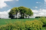
Bishop Wilton Wold is the highest point of the Yorkshire Wolds
in the East Riding
of Yorkshire
, England
. The summit, known as Garrowby Hill, lies about 5 miles (8 km) north of Pocklington
.
As with most of the wolds, it is wide, flat and agricultural in nature. The A166 road passes right by the top. However it is a Marilyn
. There is a trig point
, two covered reservoirs and an aerial
.
The British
artist
David Hockney
painted the view from the summit in 1998.
DK192 (OO-N) from 1663 HCU based at RAF Rufforth
crashed on Garrowby Hill.
As well as the 7 aircrew who were on a training flight, a passing lorry driver was also killed.
There is a memorial in a layby on the A166 at Garrowby Hill
Yorkshire Wolds
The Yorkshire Wolds are low hills in the counties of East Riding of Yorkshire and North Yorkshire in northeastern England. The name also applies to the district in which the hills lie....
in the East Riding
East Riding of Yorkshire
The East Riding of Yorkshire, or simply East Yorkshire, is a local government district with unitary authority status, and a ceremonial county of England. For ceremonial purposes the county also includes the city of Kingston upon Hull, which is a separate unitary authority...
of Yorkshire
Yorkshire
Yorkshire is a historic county of northern England and the largest in the United Kingdom. Because of its great size in comparison to other English counties, functions have been increasingly undertaken over time by its subdivisions, which have also been subject to periodic reform...
, England
England
England is a country that is part of the United Kingdom. It shares land borders with Scotland to the north and Wales to the west; the Irish Sea is to the north west, the Celtic Sea to the south west, with the North Sea to the east and the English Channel to the south separating it from continental...
. The summit, known as Garrowby Hill, lies about 5 miles (8 km) north of Pocklington
Pocklington
Pocklington is a small market town and civil parish situated at the foot of the Yorkshire Wolds in the East Riding of Yorkshire, England, approximately east of York....
.
As with most of the wolds, it is wide, flat and agricultural in nature. The A166 road passes right by the top. However it is a Marilyn
Marilyn (hill)
A Marilyn is a mountain or hill in the United Kingdom, Republic of Ireland or Isle of Man with a relative height of at least 150 metres , regardless of absolute height or other merit...
. There is a trig point
Trig point
A triangulation station, also known as a triangulation pillar, trigonometrical station, trigonometrical point, trig station, trig beacon or trig point, and sometimes informally as a trig, is a fixed surveying station, used in geodetic surveying and other surveying projects in its vicinity...
, two covered reservoirs and an aerial
Antenna (radio)
An antenna is an electrical device which converts electric currents into radio waves, and vice versa. It is usually used with a radio transmitter or radio receiver...
.
The British
United Kingdom
The United Kingdom of Great Britain and Northern IrelandIn the United Kingdom and Dependencies, other languages have been officially recognised as legitimate autochthonous languages under the European Charter for Regional or Minority Languages...
artist
Artist
An artist is a person engaged in one or more of any of a broad spectrum of activities related to creating art, practicing the arts and/or demonstrating an art. The common usage in both everyday speech and academic discourse is a practitioner in the visual arts only...
David Hockney
David Hockney
David Hockney, CH, RA, is an English painter, draughtsman, printmaker, stage designer and photographer, who is based in Bridlington, Yorkshire and Kensington, London....
painted the view from the summit in 1998.
Halifax bomber crash 1944
Around 10 am on the 7 February 1944 an Halifax MkVHandley Page Halifax
The Handley Page Halifax was one of the British front-line, four-engined heavy bombers of the Royal Air Force during the Second World War. A contemporary of the famous Avro Lancaster, the Halifax remained in service until the end of the war, performing a variety of duties in addition to bombing...
DK192 (OO-N) from 1663 HCU based at RAF Rufforth
RAF Rufforth
RAF Rufforth is a former Royal Air Force station located near Rufforth in North Yorkshire, UK.-Construction:RAF Rufforth was built by John Laing & Son Ltd for the Royal Air Force in 1941 , it is located on the south side of the village....
crashed on Garrowby Hill.
As well as the 7 aircrew who were on a training flight, a passing lorry driver was also killed.
There is a memorial in a layby on the A166 at Garrowby Hill