
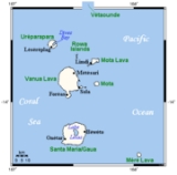
Banks Islands
Encyclopedia
The Banks Islands are a group of islands in northern Vanuatu
.
Together with the Torres Islands
to the northwest, they make up the northernmost province of Torba
. The group lies about 40 km (25 mi) north of Maewo
, and includes Gaua
and Vanua Lava
, two of the 13 largest islands in Vanuatu. In 2009, the islands supported a population of 8,533 on a land area of 780 km².
(formerly called Santa Maria), which has a rugged terrain, rising to Mount Gharat
, an active volcano at the center of the island, at 797 m (2,615 ft). The freshwater Lake Letas
in the crater is the largest lake in Vanuatu.
The slightly smaller Vanua Lava
, is higher at 946 m (3,104 ft); it also has an active volcano at Mount Suretamate (also spelled Süretimiat or Sere'ama, 921 m (3,022 ft)). To its east are two islets, Ravenga and Kwakea
(or Qakea). Sola, the provincial capital, is on this island. The third largest island, Ureparapara
(also known as Parapara), is an old volcanic cone that has been breached by the sea, forming Divers Bay on its east coast.
To the east of these larger islands lie a number of smaller ones. The furthest north, 50 km (31 mi) northeast of Ureparapara, is Vet Tagde (Vot Tande or Vot Ganai), an extinct volcano
that last erupted 3.5 million years ago. The Rowa Islands (or Reef Islands) are a few very small, low islands on a coral atoll
. Mota Lava
is the largest and highest (411 m) of this eastern chain of islands; off its southern coast, attached by high corals that one can wade through at low tide, is the tiny islet of Ra
. Mota
, Merig
, and Merelava
complete the southeastern part of the archipelago.
family. Several of these are endangered, being spoken by no more than a few hundred, and sometimes just a handful of last speakers. The language with the most speakers is Mwotlap
, the language of Mota Lava
, with 2100 speakers.
The principal economic activity is subsistence agriculture
, though copra
, coffee
, and (on Gaua) cacao are grown for export. The sulfur deposits of Mount Suretamate on Vanua Lava were formerly worked by a French company. Tourism is increasingly important, on the islands with easy transport by airplane.
and establishing a short-lived colony there.
They were later overlooked in 1774 when Captain James Cook
explored Vanuatu and believed he saw the whole chain. They were first explored by William Bligh
of the British Navy, and named after his patron Sir Joseph Banks
. They were charted by Matthew Flinders
. Vanua Lava was first explored by the New Zealand Bishop George Augustus Selwyn
in 1859.
. Ships come principally for the exports, but will also take passengers.
Vanuatu
Vanuatu , officially the Republic of Vanuatu , is an island nation located in the South Pacific Ocean. The archipelago, which is of volcanic origin, is some east of northern Australia, northeast of New Caledonia, west of Fiji, and southeast of the Solomon Islands, near New Guinea.Vanuatu was...
.
Together with the Torres Islands
Torres Islands
The Torres Islands are in the Torba Province of Vanuatu, the northernmost island group in the country. The chain of islands that make up this micro-archipelago straddle the broader cultural boundary that distinguishes Island Melanesia from several Polynesian outliers located in the neighbouring...
to the northwest, they make up the northernmost province of Torba
Torba Province
Torba is the northernmost province of Vanuatu, including the Banks Islands and the Torres Islands. Its capital is Sola.The modern name Torba is derived from the initial letters of Torres and Banks.-Facts:...
. The group lies about 40 km (25 mi) north of Maewo
Maewo
Maewo is an island in Vanuatu in Penama province, 105 km to the east of Espiritu Santo. It is 47 km long, and 6 km wide, with an area of 269 km². Its highest point is 795 m above sea level...
, and includes Gaua
Gaua
Gaua is the largest of the Banks Islands in Torba Province of northern Vanuatu. It covers 342 km².- Physical geography :...
and Vanua Lava
Vanua Lava
Vanua Lava is the second largest of the Banks Islands in Torba Province, Vanuatu, after slightly larger Gaua. It is located about 120 km north-northeast of Espiritu Santo and north of Gaua. It has a land area of 314 km². Its population numbered 2,623 in 2009.The island measures about...
, two of the 13 largest islands in Vanuatu. In 2009, the islands supported a population of 8,533 on a land area of 780 km².
Geography
The largest island is GauaGaua
Gaua is the largest of the Banks Islands in Torba Province of northern Vanuatu. It covers 342 km².- Physical geography :...
(formerly called Santa Maria), which has a rugged terrain, rising to Mount Gharat
Mount Gharat
Mount Gharat or Mount Garet is the highest peak on the volcanic island of Gaua of the Banks Islands in northern Vanuatu. The peak is located at the centre of the island, is volcanically active and is surrounded by Lake Letas on all sides except southwest.- References :*...
, an active volcano at the center of the island, at 797 m (2,615 ft). The freshwater Lake Letas
Lake Letas
Lake Letas is the largest lake in Vanuatu, located in the center of the volcanic island of Gaua of the Banks Islands in northern Vanuatu. The place submitted an application to be considered an UNESCO World Heritage Site in 2004....
in the crater is the largest lake in Vanuatu.
The slightly smaller Vanua Lava
Vanua Lava
Vanua Lava is the second largest of the Banks Islands in Torba Province, Vanuatu, after slightly larger Gaua. It is located about 120 km north-northeast of Espiritu Santo and north of Gaua. It has a land area of 314 km². Its population numbered 2,623 in 2009.The island measures about...
, is higher at 946 m (3,104 ft); it also has an active volcano at Mount Suretamate (also spelled Süretimiat or Sere'ama, 921 m (3,022 ft)). To its east are two islets, Ravenga and Kwakea
Kwakea
Kwakéa is an islet located east of Vanua Lava in the Banks Islands, Vanuatu.The island was purchased by English settlers, Frank and Alice Whitford, in the mid 1890s from the native title owners from Vanua Lava. Frank and Alice created palm plantations before a hurricane wiped out the island on...
(or Qakea). Sola, the provincial capital, is on this island. The third largest island, Ureparapara
Ureparapara
Ureparapara is the third largest island in the Banks Group in northern Vanuatu, after Gaua and Vanua Lava. It is an old volcanic cone that has been breached by the sea on its east coast, forming Divers Bay. Apart from this indentation, the island is circular in shape, with a diameter of eight...
(also known as Parapara), is an old volcanic cone that has been breached by the sea, forming Divers Bay on its east coast.
To the east of these larger islands lie a number of smaller ones. The furthest north, 50 km (31 mi) northeast of Ureparapara, is Vet Tagde (Vot Tande or Vot Ganai), an extinct volcano
Volcano
2. Bedrock3. Conduit 4. Base5. Sill6. Dike7. Layers of ash emitted by the volcano8. Flank| 9. Layers of lava emitted by the volcano10. Throat11. Parasitic cone12. Lava flow13. Vent14. Crater15...
that last erupted 3.5 million years ago. The Rowa Islands (or Reef Islands) are a few very small, low islands on a coral atoll
Atoll
An atoll is a coral island that encircles a lagoon partially or completely.- Usage :The word atoll comes from the Dhivehi word atholhu OED...
. Mota Lava
Mota Lava
Mota Lava or Motalava is the fourth largest island in the Banks Islands of Vanuatu, after Gaua, Vanua Lava and Ureparapara, with an area of . It is the largest and highest of the eastern chain of islands...
is the largest and highest (411 m) of this eastern chain of islands; off its southern coast, attached by high corals that one can wade through at low tide, is the tiny islet of Ra
Ra (island)
Ra is a small coral islet of , located in the Banks group of northern Vanuatu. The same name also refers to the single village which is situated within this islet....
. Mota
Mota (island)
Mota is an extinct volcanic island in the Banks group of Torba Province in northern Vanuatu.683 people live on Mota in coastal villages around the island. The names of the villages are Liwotqei, Lotawan, Mariu, Tasmate, Garamal, Tuqetap, and Veverao....
, Merig
Merig
Merig is a small island located 20 km east of Gaua, in the Banks Islands of northern Vanuatu.The island is about 800 meters wide, and has a circumference of 2.2 km....
, and Merelava
Merelava
Merelava is an island in the Banks Islands of northern Vanuatu. It is situated in the southeastern part of the archipelago near Mota and Merig. The island is administratively part of Torba Province. Merelava has also been known as Star Island. It is located about 50 km east of Gaua.-Population and...
complete the southeastern part of the archipelago.
Languages and culture
The population of the Banks Islands speak fifteen different languages, which all belong to the Oceanic subgroup of the AustronesianAustronesian languages
The Austronesian languages are a language family widely dispersed throughout the islands of Southeast Asia and the Pacific, with a few members spoken on continental Asia that are spoken by about 386 million people. It is on par with Indo-European, Niger-Congo, Afroasiatic and Uralic as one of the...
family. Several of these are endangered, being spoken by no more than a few hundred, and sometimes just a handful of last speakers. The language with the most speakers is Mwotlap
Mwotlap
-External links: *...
, the language of Mota Lava
Mota Lava
Mota Lava or Motalava is the fourth largest island in the Banks Islands of Vanuatu, after Gaua, Vanua Lava and Ureparapara, with an area of . It is the largest and highest of the eastern chain of islands...
, with 2100 speakers.
The principal economic activity is subsistence agriculture
Subsistence agriculture
Subsistence agriculture is self-sufficiency farming in which the farmers focus on growing enough food to feed their families. The typical subsistence farm has a range of crops and animals needed by the family to eat and clothe themselves during the year. Planting decisions are made with an eye...
, though copra
Copra
Copra is the dried meat, or kernel, of the coconut. Coconut oil extracted from it has made copra an important agricultural commodity for many coconut-producing countries. It also yields coconut cake which is mainly used as feed for livestock.-Production:...
, coffee
Coffee
Coffee is a brewed beverage with a dark,init brooo acidic flavor prepared from the roasted seeds of the coffee plant, colloquially called coffee beans. The beans are found in coffee cherries, which grow on trees cultivated in over 70 countries, primarily in equatorial Latin America, Southeast Asia,...
, and (on Gaua) cacao are grown for export. The sulfur deposits of Mount Suretamate on Vanua Lava were formerly worked by a French company. Tourism is increasingly important, on the islands with easy transport by airplane.
History
The Banks Islands were the first part of Vanuatu discovered by a European explorer, in 1606 when Portuguese explorer Pedro Fernández de Quirós sailed past Merelava and stopped at Gaua, before landing on Espiritu SantoEspiritu Santo
Espiritu Santo is the largest island in the nation of Vanuatu, with an area of . It belongs to the archipelago of the New Hebrides in the Pacific region of Melanesia. It is in the Sanma Province of Vanuatu....
and establishing a short-lived colony there.
They were later overlooked in 1774 when Captain James Cook
James Cook
Captain James Cook, FRS, RN was a British explorer, navigator and cartographer who ultimately rose to the rank of captain in the Royal Navy...
explored Vanuatu and believed he saw the whole chain. They were first explored by William Bligh
William Bligh
Vice Admiral William Bligh FRS RN was an officer of the British Royal Navy and a colonial administrator. A notorious mutiny occurred during his command of HMAV Bounty in 1789; Bligh and his loyal men made a remarkable voyage to Timor, after being set adrift in the Bounty's launch by the mutineers...
of the British Navy, and named after his patron Sir Joseph Banks
Joseph Banks
Sir Joseph Banks, 1st Baronet, GCB, PRS was an English naturalist, botanist and patron of the natural sciences. He took part in Captain James Cook's first great voyage . Banks is credited with the introduction to the Western world of eucalyptus, acacia, mimosa and the genus named after him,...
. They were charted by Matthew Flinders
Matthew Flinders
Captain Matthew Flinders RN was one of the most successful navigators and cartographers of his age. In a career that spanned just over twenty years, he sailed with Captain William Bligh, circumnavigated Australia and encouraged the use of that name for the continent, which had previously been...
. Vanua Lava was first explored by the New Zealand Bishop George Augustus Selwyn
George Augustus Selwyn
George Augustus Selwyn was the first Anglican Bishop of New Zealand. He was Bishop of New Zealand from 1841 to 1858. His diocese was then subdivided and Selwyn was Primate of New Zealand from 1858 to 1868. He was Bishop of Lichfield from 1868 to 1878...
in 1859.
Transport
There are airports on Mota Lava, Vanua Lava, and Gaua, which have a few flights a week with Air VanuatuAir Vanuatu
Air Vanuatu is an airline with its head office in the Air Vanuatu House, Port Vila, Vanuatu. It is Vanuatu's national flag carrier, operating to Australia, New Zealand and points in the South Pacific...
. Ships come principally for the exports, but will also take passengers.