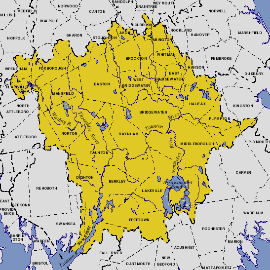
Taunton River Watershed
Encyclopedia

Massachusetts
The Commonwealth of Massachusetts is a state in the New England region of the northeastern United States of America. It is bordered by Rhode Island and Connecticut to the south, New York to the west, and Vermont and New Hampshire to the north; at its east lies the Atlantic Ocean. As of the 2010...
, USA. It is the second largest watershed
Drainage basin
A drainage basin is an extent or an area of land where surface water from rain and melting snow or ice converges to a single point, usually the exit of the basin, where the waters join another waterbody, such as a river, lake, reservoir, estuary, wetland, sea, or ocean...
in the state. Also, it is a significant part of a much larger multi-state watershed, the Narragansett Bay
Narragansett Bay
Narragansett Bay is a bay and estuary on the north side of Rhode Island Sound. Covering 147 mi2 , the Bay forms New England's largest estuary, which functions as an expansive natural harbor, and includes a small archipelago...
watershed.
The Taunton River
Taunton River
The Taunton River , is a river in southeastern Massachusetts in the United States. It arises from the confluence of the Town River and Matfield River, in the town of Bridgewater...
watershed is mostly situated in Bristol County
Bristol County, Massachusetts
-Demographics:As of the census of 2000, there were 534,678 people, 205,411 households, and 140,706 families residing in the county. The population density was 962 people per square mile . There were 216,918 housing units at an average density of 390 per square mile...
, while some portions of it extends into parts of southern Norfolk County
Norfolk County, Massachusetts
-National protected areas:* Adams National Historical Park* Boston Harbor Islands National Recreation Area * Frederick Law Olmsted National Historic Site* John Fitzgerald Kennedy National Historic Site-Demographics:...
and western Plymouth County
Plymouth County, Massachusetts
Plymouth County is a county located in the U.S. state of Massachusetts. As of 2010, the population was 494,919. Its county seats are Plymouth and Brockton...
.
Composition
The Taunton River watershed includes:- 7 species of freshwater mussels
- 27 different habitat types
- 29 species of native fish
- 114 species of birds. of canoeable river
- 221 lakes and ponds
- Hockomock SwampHockomock SwampThe Hockomock Swamp is a vast wetland encompassing much of the northern part of southeastern Massachusetts. This land is considered the second largest wetland in the state...
of 16800 acres (6,798.7 ha)
Environmental advocacy
This is an incomplete list of environmental groups and organizations that advocate protecting, by legislation and grants, the Taunton River Watershed:- Sheehan Family Foundation Grant
- Taunton River Watershed Alliance
- Taunton River Wild and Scenic Rivers Study
See also
- List of Massachusetts rivers
- Three Mile River
External links
- Sheehan Family Foundation Grant Official Home Page
- American Rivers site on the Taunton River.
- Taunton River Stewardship Program: The Wildlands Trust of Southeastern Massachusetts Official Home Page
- Taunton River Watershed Alliance Official Home Page
- University of Rhode Island: Taunton River Watershed critical resource atlas.
- TauntonRiver.org (The Taunton River Wild & Scenic River Study) Official Home Page
- Taunton River Journal

