
1955 Great Plains tornado outbreak
Encyclopedia
The 1955 Great Plains tornado outbreak was a deadly tornado outbreak
that struck the southern and central U.S Plain States on May 25–26, 1955. It produced at least 46 tornadoes across 7 states including 2 F5 tornadoes in Blackwell, Oklahoma
and Udall, Kansas
. The outbreak killed 102 from 3 tornadoes while injuring hundreds more. Unusual electromagnetic
activity was observed, including St. Elmo's fire
.
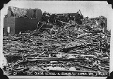
at around 9:00 PM CDT before crossing through the eastern portions of the Kay County
town of Blackwell as a 500-yard F5 wedge. It claimed the lives of 20 people in Blackwell and injured over 200 before crossing and dissipating into Cowley County, Kansas
. In addition of destroying nearly 200 homes, the tornado also demolished the town's main employers including the Acme Foundry and the Hazel Atlas Glass plant. The local hospital
also sustained major damage. Most of the western half of the town spared the worst of the damage.
30 minutes later, the same supercell
that spawned the Blackwell tornado produced another violent tornado just east of the first tornado track near the Kansas
/Oklahoma
border. It proceeded northward across Sumner
and Cowley counties. The town of Udall was especially hard hit with F5 damage which disintegrated numerous structures and homes all across the town when the funnel, about 1300 yards-wide, hit it at around 10:30 PM CDT. It later dissipated after traveling over 50 miles from the Oklahoma border to southeast of Wichita
. This tornado was the deadliest in the state's history with 80 fatalities and over 200 injured.
Most NWS
records had classified the event as two distinct tornadoes which formed from the same supercell which formed in southern Oklahoma and traveled through metro Oklahoma City
where it produced weaker tornadoes with minimal damage in the southern suburbs of Norman
and Chickasha
.
In addition NWS officials confirmed an additional F2 tornado near Tonkawa
which may have been either part of the Blackwell tornado or a satellite tornado. Other tornadoes in the region occurred on May 27 near the same region but did little damage.
Another deadly tornado occurred in Cheyenne
in Roger Mills County
in southwestern Oklahoma south of Woodward
during the late afternoon killing 2. This storm originated from the Texas
panhandle. The final tornado in the hardest hit region occurred during the early morning hours of May 26 when a weak tornado occurred in Salisaw
in extreme eastern Oklahoma in Sequoyah
near the Arkansas
border.
Numerous tornadoes occurred across the Midwestern states from Arkansas to Illinois. The strongest tornado was located near the Little Rock area but no fatalities were reported with this tornado or any other reported on May 26.
Tornado outbreak
While there is no single agreed upon definition, generally at least 6-10 tornadoes produced by the same synoptic scale weather system is considered a tornado outbreak. The tornadoes usually occur within the same day, or continue into the early morning hours of the succeeding day, and within the...
that struck the southern and central U.S Plain States on May 25–26, 1955. It produced at least 46 tornadoes across 7 states including 2 F5 tornadoes in Blackwell, Oklahoma
Blackwell, Oklahoma
Blackwell is a city in Kay County, Oklahoma, United States, located at the intersection of U.S. Highway 177 and State Highway 11 along Interstate 35. The population was 7,668 at the 2000 census. Blackwell was established following the September 16, 1893 Cherokee Outlet land run by A. J. Blackwell...
and Udall, Kansas
Udall, Kansas
Udall is a city in Cowley County, Kansas, United States. As of the 2010 census, the city population was 746.-History:Founded in 1881 by J.M. Napier and P.W. Smith. Udall was named after English author Cornelius Udall....
. The outbreak killed 102 from 3 tornadoes while injuring hundreds more. Unusual electromagnetic
Electromagnetism
Electromagnetism is one of the four fundamental interactions in nature. The other three are the strong interaction, the weak interaction and gravitation...
activity was observed, including St. Elmo's fire
St. Elmo's fire
St. Elmo's fire is a weather phenomenon in which luminous plasma is created by a coronal discharge from a grounded object in an electric field in the atmosphere St. Elmo's fire is named after St. Erasmus of Formiae St. Elmo's fire (also St. Elmo's light) is a weather phenomenon in which luminous...
.
Blackwell-Udall tornadoes
The Blackwell tornado formed in Noble CountyNoble County, Oklahoma
Noble County is a county located in the U.S. state of Oklahoma. As of 2010, the population was 11,561. Its county seat is Perry.-21st century:In 2010, the Keystone-Cushing Pipeline was constructed north to south through Noble County....
at around 9:00 PM CDT before crossing through the eastern portions of the Kay County
Kay County, Oklahoma
Kay County is a county located in the U.S. state of Oklahoma. As of 2000, the population was 48,080. Its county seat is Newkirk. The largest city in Kay County is Ponca City.-19th century:...
town of Blackwell as a 500-yard F5 wedge. It claimed the lives of 20 people in Blackwell and injured over 200 before crossing and dissipating into Cowley County, Kansas
Cowley County, Kansas
Cowley County is a county located in south-central Kansas, in the Central United States. As of the 2010 census, the county population was 36,311. Its county seat and most populous city is Winfield...
. In addition of destroying nearly 200 homes, the tornado also demolished the town's main employers including the Acme Foundry and the Hazel Atlas Glass plant. The local hospital
Hospital
A hospital is a health care institution providing patient treatment by specialized staff and equipment. Hospitals often, but not always, provide for inpatient care or longer-term patient stays....
also sustained major damage. Most of the western half of the town spared the worst of the damage.
30 minutes later, the same supercell
Supercell
A supercell is a thunderstorm that is characterized by the presence of a mesocyclone: a deep, continuously-rotating updraft. For this reason, these storms are sometimes referred to as rotating thunderstorms...
that spawned the Blackwell tornado produced another violent tornado just east of the first tornado track near the Kansas
Kansas
Kansas is a US state located in the Midwestern United States. It is named after the Kansas River which flows through it, which in turn was named after the Kansa Native American tribe, which inhabited the area. The tribe's name is often said to mean "people of the wind" or "people of the south...
/Oklahoma
Oklahoma
Oklahoma is a state located in the South Central region of the United States of America. With an estimated 3,751,351 residents as of the 2010 census and a land area of 68,667 square miles , Oklahoma is the 28th most populous and 20th-largest state...
border. It proceeded northward across Sumner
Sumner County, Kansas
Sumner County is a county located in the U.S. state of Kansas. The county's population was 24,132 for the 2010 census. Its county seat is Wellington. Sumner County is part of the Wichita, Kansas Metropolitan Statistical Area. It was named in honor of Charles Sumner, a U.S...
and Cowley counties. The town of Udall was especially hard hit with F5 damage which disintegrated numerous structures and homes all across the town when the funnel, about 1300 yards-wide, hit it at around 10:30 PM CDT. It later dissipated after traveling over 50 miles from the Oklahoma border to southeast of Wichita
Wichita, Kansas
Wichita is the largest city in the U.S. state of Kansas.As of the 2010 census, the city population was 382,368. Located in south-central Kansas on the Arkansas River, Wichita is the county seat of Sedgwick County and the principal city of the Wichita metropolitan area...
. This tornado was the deadliest in the state's history with 80 fatalities and over 200 injured.
Most NWS
National Weather Service
The National Weather Service , once known as the Weather Bureau, is one of the six scientific agencies that make up the National Oceanic and Atmospheric Administration of the United States government...
records had classified the event as two distinct tornadoes which formed from the same supercell which formed in southern Oklahoma and traveled through metro Oklahoma City
Oklahoma city
Oklahoma City is the capital and largest city of the U.S. state of Oklahoma.Oklahoma City may also refer to:*Oklahoma City metropolitan area*Downtown Oklahoma City*Uptown Oklahoma City*Oklahoma City bombing*Oklahoma City National Memorial...
where it produced weaker tornadoes with minimal damage in the southern suburbs of Norman
Norman, Oklahoma
Norman is a city in Cleveland County, Oklahoma, United States, and is located south of downtown Oklahoma City. It is part of the Oklahoma City metropolitan area. As of the 2010 census, Norman was to have 110,925 full-time residents, making it the third-largest city in Oklahoma and the...
and Chickasha
Chickasha, Oklahoma
Chickasha is a city in and the county seat, business and employment center of Grady County, Oklahoma, United States. The population was 15,850 at the 2000 census. Chickasha is home to the University of Science and Arts of Oklahoma and hosts an annual Festival of Light celebration located at...
.
In addition NWS officials confirmed an additional F2 tornado near Tonkawa
Tonkawa, Oklahoma
Tonkawa is a city in Kay County, Oklahoma, United States, along the Salt Fork Arkansas River. The population was 3,299 at the 2000 census.-History:...
which may have been either part of the Blackwell tornado or a satellite tornado. Other tornadoes in the region occurred on May 27 near the same region but did little damage.
Other tornadoes
| State | Total | County | County total |
|---|---|---|---|
| Kansas Kansas Kansas is a US state located in the Midwestern United States. It is named after the Kansas River which flows through it, which in turn was named after the Kansa Native American tribe, which inhabited the area. The tribe's name is often said to mean "people of the wind" or "people of the south... |
80 | Cowley Cowley County, Kansas Cowley County is a county located in south-central Kansas, in the Central United States. As of the 2010 census, the county population was 36,311. Its county seat and most populous city is Winfield... |
75 |
| Sumner Sumner County, Kansas Sumner County is a county located in the U.S. state of Kansas. The county's population was 24,132 for the 2010 census. Its county seat is Wellington. Sumner County is part of the Wichita, Kansas Metropolitan Statistical Area. It was named in honor of Charles Sumner, a U.S... |
5 | ||
| Oklahoma Oklahoma Oklahoma is a state located in the South Central region of the United States of America. With an estimated 3,751,351 residents as of the 2010 census and a land area of 68,667 square miles , Oklahoma is the 28th most populous and 20th-largest state... |
22 | Kay Kay County, Oklahoma Kay County is a county located in the U.S. state of Oklahoma. As of 2000, the population was 48,080. Its county seat is Newkirk. The largest city in Kay County is Ponca City.-19th century:... |
20 |
| Roger Mills Roger Mills County, Oklahoma Roger Mills County is a county located in the U.S. state of Oklahoma. As of 2000, the population was 3,436. Its county seat is Cheyenne.-History:Roger Mills County takes its name from Roger Q. Mills, a prominent American politician from Texas... |
2 | ||
| Totals | 102 | ||
| All deaths were tornado-related | |||
Another deadly tornado occurred in Cheyenne
Cheyenne, Oklahoma
Cheyenne is a town in Roger Mills County, Oklahoma, United States. The population was 801 at the 2010 census. It is the county seat of Roger Mills County.-History:...
in Roger Mills County
Roger Mills County, Oklahoma
Roger Mills County is a county located in the U.S. state of Oklahoma. As of 2000, the population was 3,436. Its county seat is Cheyenne.-History:Roger Mills County takes its name from Roger Q. Mills, a prominent American politician from Texas...
in southwestern Oklahoma south of Woodward
Woodward, Oklahoma
Woodward is a city in and the county seat of Woodward County, Oklahoma, United States. It is the largest city in a nine-county area. The population was 12,051 at the 2010 census....
during the late afternoon killing 2. This storm originated from the Texas
Texas
Texas is the second largest U.S. state by both area and population, and the largest state by area in the contiguous United States.The name, based on the Caddo word "Tejas" meaning "friends" or "allies", was applied by the Spanish to the Caddo themselves and to the region of their settlement in...
panhandle. The final tornado in the hardest hit region occurred during the early morning hours of May 26 when a weak tornado occurred in Salisaw
Sallisaw, Oklahoma
Sallisaw is a city in Sequoyah County, Oklahoma, United States. It is part of the Fort Smith, Arkansas-Oklahoma Metropolitan Statistical Area. The population was 8,880 at the 2010 census. It is the county seat of Sequoyah County. It has three highways running through it: U.S. 59, or Kerr Boulevard,...
in extreme eastern Oklahoma in Sequoyah
Sequoyah County, Oklahoma
Sequoyah County is a county located in the U.S. state of Oklahoma. It is part of the Fort Smith, Arkansas-Oklahoma Metropolitan Statistical Area. As of 2000, the population was 38,972. Its county seat is Sallisaw.-History:...
near the Arkansas
Arkansas
Arkansas is a state located in the southern region of the United States. Its name is an Algonquian name of the Quapaw Indians. Arkansas shares borders with six states , and its eastern border is largely defined by the Mississippi River...
border.
Numerous tornadoes occurred across the Midwestern states from Arkansas to Illinois. The strongest tornado was located near the Little Rock area but no fatalities were reported with this tornado or any other reported on May 26.
Tornado table
- Sources: http://www.srh.noaa.gov/oun/?n=events-19550525-oktornadotable http://www.tornadohistoryproject.com/index.php
May 25, 1955 event
| F# Fujita scale The Fujita scale , or Fujita-Pearson scale, is a scale for rating tornado intensity, based primarily on the damage tornadoes inflict on human-built structures and vegetation... |
Location | County | Time (UTC) | Path length | Damage | |
|---|---|---|---|---|---|---|
| Texas Texas Texas is the second largest U.S. state by both area and population, and the largest state by area in the contiguous United States.The name, based on the Caddo word "Tejas" meaning "friends" or "allies", was applied by the Spanish to the Caddo themselves and to the region of their settlement in... |
||||||
| F4 | SW of Aberdeen, TX to S of Dempsey, OK | Collingsworth, TX, Wheeler, Roger Mills, OK Roger Mills County, Oklahoma Roger Mills County is a county located in the U.S. state of Oklahoma. As of 2000, the population was 3,436. Its county seat is Cheyenne.-History:Roger Mills County takes its name from Roger Q. Mills, a prominent American politician from Texas... |
2117 | 45.1 miles (72.2 km) |
2 deaths | |
| F0 | SE of Sterling City Sterling City, Texas Sterling City is a city in and the county seat of Sterling County, Texas, United States. The population was 1,081 at the 2000 census, but had dropped to 982 by 2009.... |
Sterling Sterling County, Texas Sterling County is a county located on the Edwards Plateau in the U.S. state of Texas. In 2000, its population was 1,393. Its county seat is Sterling City. The county is named for W. S. Sterling, an early settler in the area. Sterling County is one of 30 prohibition, or entirely dry, counties in... |
0000 | 0.1 miles (0.16 km) |
||
| F1 | E of Rotan Rotan, Texas Rotan is a city in Fisher County, Texas, United States. The population was 1,611 at the 2000 census.-Geography:Rotan is located at .... |
Fisher | 0430 | 0.3 miles (0.5 km) |
||
| F2 | SW of Benjamin Benjamin, Texas Benjamin is a city in Knox County, Texas, United States. It is the county seat of Knox County. The population was 258 at the 2010 census.-Geography:Benjamin is located at . It is situated at the junction of U.S... |
Knox Knox County, Texas As of the census of 2000, there were 4,253 people, 1,690 households, and 1,166 families residing in the county. The population density was 5 people per square mile . There were 2,129 housing units at an average density of 2 per square mile... |
0530 | 11.9 miles (19 km) |
||
| F2 | Wichita Falls Wichita Falls, Texas Wichita Falls is a city in and the county seat of Wichita County, Texas, United States, United States. Wichita Falls is the principal city of the Wichita Falls Metropolitan Statistical Area, which encompasses all of Archer, Clay and Wichita counties. According to the U.S. Census estimate of 2010,... area |
Wichita Wichita County, Texas As of the census of 2000, there were 131,664 people, 48,441 households, and 32,891 families residing in the county. The population density was 210 people per square mile . There were 53,304 housing units at an average density of 85 per square mile... |
0738 | 1.3 miles (2.1 km) |
||
| Oklahoma Oklahoma Oklahoma is a state located in the South Central region of the United States of America. With an estimated 3,751,351 residents as of the 2010 census and a land area of 68,667 square miles , Oklahoma is the 28th most populous and 20th-largest state... |
||||||
| F1 | E of Shattuck Shattuck, Oklahoma Shattuck is a town in Ellis County, Oklahoma, United States. The population was 1,356 at the 2010 census.-Geography:Shattuck is located at .According to the United States Census Bureau, the town has a total area of , all of it land.... |
Ellis Ellis County, Oklahoma Ellis County is a county located in the U.S. state of Oklahoma. As of 2000, the population was 4,075. Its county seat is Arnett.-Geography:... |
0000 | 4.9 miles (7.8 km) |
||
| F1 | NE of Rush Springs Rush Springs, Oklahoma Rush Springs is a town in Grady County, Oklahoma, United States. The population was 1,278 at the 2000 census.-Geography:Rush Springs is located at .... |
Grady Grady County, Oklahoma Grady County is a county located in the U.S. state of Oklahoma. As of 2006, the population was 50,490. Its county seat is Chickasha.Grady County is part of the Oklahoma City Metropolitan Statistical Area.-History:... |
0000 | 0.1 miles (0.16 km) |
||
| F0 | NE of Mayfield | Beckham Beckham County, Oklahoma Beckham County is a county located in the U.S. state of Oklahoma. As of 2000, the population was 19,799. Its county seat is Sayre.Founded upon statehood in 1907, Beckham County was named for J. C. W... |
0005 | 3.8 miles (6.1 km) |
||
| F1 | NE of Kingfisher Kingfisher, Oklahoma Kingfisher is a city in and the county seat of Kingfisher County, Oklahoma, United States. The population was 4,380 at the 2000 census. It is the former home and namesake of Kingfisher College.-History:... |
Kinfisher Kingfisher County, Oklahoma Kingfisher County is a county located in the U.S. state of Oklahoma. As of 2000, the population was 14,384. Its county seat is Kingfisher.-History:... |
0100 | 0.1 miles (0.16 km) |
||
| F2 | NE of Camargo Camargo, Oklahoma Camargo is a town in Dewey County, Oklahoma, United States. The population was 178 at the 2010 census.-Geography:Camargo is located at .According to the United States Census Bureau, the town has a total area of , all of it land.... |
Dewey Dewey County, Oklahoma Dewey County is a county located in the U.S. state of Oklahoma. As of 2000, the population was 4,743. Its county seat is Taloga.-Geography:According to the U.S. Census Bureau, the county has a total area of , of which is land and is water.... |
0230 | 5.1 miles (8.2 km) |
||
| F3 | S of Deer Creek Deer Creek, Oklahoma Deer Creek is a town in Grant County, Oklahoma, United States. The population was 147 at the 2000 census.-Geography:Deer Creek is located at .... |
Grant Grant County, Oklahoma Grant County is a county located in the U.S. state of Oklahoma. As of 2010 census, the population was 4,527. Its county seat is Medford.-History:... |
0300 | 13.3 miles (21.3 km) |
||
| F2 | NE of Tonkawa Tonkawa, Oklahoma Tonkawa is a city in Kay County, Oklahoma, United States, along the Salt Fork Arkansas River. The population was 3,299 at the 2000 census.-History:... |
Kay Kay County, Oklahoma Kay County is a county located in the U.S. state of Oklahoma. As of 2000, the population was 48,080. Its county seat is Newkirk. The largest city in Kay County is Ponca City.-19th century:... |
0300 | 2.7 miles (4.3 km) |
||
| F5 | NE of Tonkawa, OK Tonkawa, Oklahoma Tonkawa is a city in Kay County, Oklahoma, United States, along the Salt Fork Arkansas River. The population was 3,299 at the 2000 census.-History:... to South Haven, KS South Haven, Kansas South Haven is a city in Sumner County, Kansas, United States. As of the 2010 census, the city population was 363.-Geography:South Haven is located at... |
Kay, OK Kay County, Oklahoma Kay County is a county located in the U.S. state of Oklahoma. As of 2000, the population was 48,080. Its county seat is Newkirk. The largest city in Kay County is Ponca City.-19th century:... , Sumner, KS Sumner County, Kansas Sumner County is a county located in the U.S. state of Kansas. The county's population was 24,132 for the 2010 census. Its county seat is Wellington. Sumner County is part of the Wichita, Kansas Metropolitan Statistical Area. It was named in honor of Charles Sumner, a U.S... |
0326 | 28.4 miles (45.4 km) |
20 deaths | |
| F5 | E of Peckham, OK to NE of Atlanta, KS Atlanta, Kansas Atlanta is a city in Cowley County, Kansas, United States. As of the 2010 census, the city population was 195.-Geography:Atlanta is located at . According to the United States Census Bureau, the city has a total area of , all of it land.-Demographics:As of the census of 2000, there were 255... |
Kay, OK Kay County, Oklahoma Kay County is a county located in the U.S. state of Oklahoma. As of 2000, the population was 48,080. Its county seat is Newkirk. The largest city in Kay County is Ponca City.-19th century:... , Sumner, KS Sumner County, Kansas Sumner County is a county located in the U.S. state of Kansas. The county's population was 24,132 for the 2010 census. Its county seat is Wellington. Sumner County is part of the Wichita, Kansas Metropolitan Statistical Area. It was named in honor of Charles Sumner, a U.S... , Cowley Cowley County, Kansas Cowley County is a county located in south-central Kansas, in the Central United States. As of the 2010 census, the county population was 36,311. Its county seat and most populous city is Winfield... |
0400 | 56.4 miles (90.2 km) |
80 deaths | |
| F1 | W of Martha Martha, Oklahoma Martha is a town in Jackson County, Oklahoma, United States. The population was 162 at the 2010 census.-Geography:Martha is located at .According to the United States Census Bureau, the town has a total area of , all of it land.... |
Jackson Jackson County, Oklahoma Jackson County is a county located in the U.S. state of Oklahoma. As of 2000, the population was 28,439. Its county seat is Altus.-Geography:According to the U.S. Census Bureau, the county has a total area of , of which is land and is water.... |
0500 | 6.2 miles (9.9 km) |
||
| Kansas Kansas Kansas is a US state located in the Midwestern United States. It is named after the Kansas River which flows through it, which in turn was named after the Kansa Native American tribe, which inhabited the area. The tribe's name is often said to mean "people of the wind" or "people of the south... |
||||||
| F1 | NW of Antonino | Ellis Ellis County, Kansas Ellis County is a county located in Northwest Kansas, in the Central United States. As of the 2010 census, the county population was 28,452. Its county seat and most populous city is Hays... |
0140 | 0.1 miles (0.16 km) |
||
| F2 | E of Osage City Osage City, Kansas Osage City is a city in Osage County, Kansas, United States. The population was 3,034 at the 2000 census. It is part of the Topeka, Kansas Metropolitan Statistical Area.-Geography:Osage City is located at... to Leavenworth Leavenworth, Kansas Leavenworth is the largest city and county seat of Leavenworth County, in the U.S. state of Kansas and within the Kansas City, Missouri Metropolitan Area. Located in the northeast portion of the state, it is on the west bank of the Missouri River. As of the 2010 census, the city population was... |
Osage Osage County, Kansas Osage County is a county located in east-central Kansas, in the Central United States. As of the 2010 census, the county population was 16295. Its county seat is Lyndon, and its most populous city is Osage City. The county along with Shawnee, Jackson, Jefferson, and Wabaunsee counties is... , Douglas Douglas County, Kansas Douglas County is a county located in northeast Kansas, in the Central United States. As of the 2010 census, the county population was 110,826... , Leavenworth Leavenworth County, Kansas Leavenworth County is a county located in Northeast Kansas, in the Central United States. As of the 2010 census, the county population was 76,227. Its county seat and most populous city is Leavenworth... |
0627 | 66.2 miles (105.9 km) |
||
| Source: Tornado History Project - May 25, 1955 Storm Data | ||||||
May 26, 1955 event
| F# Fujita scale The Fujita scale , or Fujita-Pearson scale, is a scale for rating tornado intensity, based primarily on the damage tornadoes inflict on human-built structures and vegetation... |
Location | County | Time (UTC) | Path length | Damage | |
|---|---|---|---|---|---|---|
| Oklahoma Oklahoma Oklahoma is a state located in the South Central region of the United States of America. With an estimated 3,751,351 residents as of the 2010 census and a land area of 68,667 square miles , Oklahoma is the 28th most populous and 20th-largest state... |
||||||
| F0 | Velma Velma, Oklahoma Velma is a town in Stephens County, Oklahoma, United States. The population was 664 at the 2000 census.-Geography:Velma is located at .According to the United States Census Bureau, the town has a total area of , all of it land.... area |
Stephens Stephens County, Oklahoma Stephens County is a county located in the U.S. state of Oklahoma. As of 2000, the population was 43,182. Its county seat is Duncan.-Geography:According to the U.S. Census Bureau, the county has a total area of 2,308 km²... |
0830 | 0.1 miles (0.16 km) |
||
| F1 | N of Chickasha Chickasha, Oklahoma Chickasha is a city in and the county seat, business and employment center of Grady County, Oklahoma, United States. The population was 15,850 at the 2000 census. Chickasha is home to the University of Science and Arts of Oklahoma and hosts an annual Festival of Light celebration located at... |
Grady Grady County, Oklahoma Grady County is a county located in the U.S. state of Oklahoma. As of 2006, the population was 50,490. Its county seat is Chickasha.Grady County is part of the Oklahoma City Metropolitan Statistical Area.-History:... |
0830 | 0.1 miles (0.16 km) |
||
| F1 | Oklahoma City Oklahoma City, Oklahoma Oklahoma City is the capital and the largest city in the state of Oklahoma. The county seat of Oklahoma County, the city ranks 31st among United States cities in population. The city's population, from the 2010 census, was 579,999, with a metro-area population of 1,252,987 . In 2010, the Oklahoma... area (south) |
Oklahoma Oklahoma County, Oklahoma Oklahoma County is a county located in the central partof the U.S. state of Oklahoma. The population was 718,633 at the 2010 census. The county seat and principal city is Oklahoma City... |
0900 | 0.5 miles (0.8 km) |
||
| F1 | E of Moore Moore, Oklahoma Moore is a city in Cleveland County, Oklahoma and is part of the Oklahoma City Metropolitan Area. The population was 55,081 at the 2010 census, making it the seventh largest city in the state of Oklahoma.... |
Cleveland Cleveland County, Oklahoma Cleveland County is a county in the central part of the U.S. state of Oklahoma. The population was 255,755 at the 2010 census. Its county seat is Norman. Cleveland County is part of the Oklahoma City Metropolitan Statistical Area.-History:... |
0900 | 11.6 miles (18.6 km) |
||
| F0 | SW of Shawnee Shawnee, Oklahoma Shawnee is a city in Pottawatomie County, Oklahoma, United States. The population was 29,857 at the 2010 census. The city is part of the Oklahoma City-Shawnee Combined Statistical Area; it is also the county seat of Pottawatomie County and the principal city of the Shawnee Micropolitan Statistical... |
Pottawatomie Pottawatomie County, Oklahoma Pottawatomie County is a county located in the U.S. state of Oklahoma. The population was 65,521 as of the 2000 census. Its county seat is Shawnee... |
0930 | 0.1 miles (0.16 km) |
||
| F0 | Cushing Cushing, Oklahoma Cushing is a city in Payne County, Oklahoma, United States. The population was 8,371 at the 2000 census.The city was established after the Land Run of 1891 by Billy Rae Little. It was named for Marshall Cushing, private secretary to U.S. Postmaster General John Wanamaker... area |
Payne Payne County, Oklahoma Payne County is a county in the U.S. state of Oklahoma. The population as of 2010 was 77,350. Its county seat is Stillwater, and the county is named for Capt. David L. Payne... |
1000 | 0.1 miles (0.16 km) |
||
| F0 | Durant Durant, Oklahoma Durant is a city in Bryan County, Oklahoma, United States. The population was 15,877 at the 2010 census. Durant is the principal city of the Durant Micropolitan Statistical Area, which had a population of 42,416 in 2010... area |
Bryan Bryan County, Oklahoma Bryan County is a county located in the U.S. state of Oklahoma. The population was 36,534 at the 2000 census. Its county seat is Durant. The county shares the same boundaries as the Durant Micropolitan Area. It is also home to the headquarters of the Choctaw Nation of Oklahoma located in Durant... |
1120 | 4.5 miles (7.2 km) |
||
| F1 | Sallisaw Sallisaw, Oklahoma Sallisaw is a city in Sequoyah County, Oklahoma, United States. It is part of the Fort Smith, Arkansas-Oklahoma Metropolitan Statistical Area. The population was 8,880 at the 2010 census. It is the county seat of Sequoyah County. It has three highways running through it: U.S. 59, or Kerr Boulevard,... to NE of Stony Point Stony Point, Oklahoma Stony Point is a census-designated place in Sequoyah County, Oklahoma, United States. It is part of the Fort Smith, Arkansas-Oklahoma Metropolitan Statistical Area... |
Sequoyah Sequoyah County, Oklahoma Sequoyah County is a county located in the U.S. state of Oklahoma. It is part of the Fort Smith, Arkansas-Oklahoma Metropolitan Statistical Area. As of 2000, the population was 38,972. Its county seat is Sallisaw.-History:... |
1245 | 14.2 miles (22.7 km) |
||
| Missouri Missouri Missouri is a US state located in the Midwestern United States, bordered by Iowa, Illinois, Kentucky, Tennessee, Arkansas, Oklahoma, Kansas and Nebraska. With a 2010 population of 5,988,927, Missouri is the 18th most populous state in the nation and the fifth most populous in the Midwest. It... |
||||||
| F1 | Joplin Joplin, Missouri Joplin is a city in southern Jasper County and northern Newton County in the southwestern corner of the US state of Missouri. Joplin is the largest city in Jasper County, though it is not the county seat. As of the 2010 census, the city population was 50,150... area |
Jasper Jasper County, Missouri Jasper County is a county located in the US state of Missouri. It is included in the Joplin, Missouri Metropolitan Statistical Area. The 2010 total population of Jasper County was 117,404. It is the ninth most populous county in Missouri. Its county seat is Carthage, making it one of the few... |
1300 | 2.7 miles (4.3 km) |
||
| F1 | SW of Clarksburg Clarksburg, Missouri Clarksburg is a city in Moniteau County, Missouri, United States. The population was 375 at the 2000 census. It is part of the Jefferson City, Missouri Metropolitan Statistical Area.-Geography:Clarksburg is located at .... |
Moniteau | 1545 | 0.2 miles (0.32 km) |
||
| F0 | N of Norborne Norborne, Missouri Norborne is a city in Carroll County, Missouri, United States. The population was 805 at the 2000 census.Norborne was founded in 1868 by Norborne B. Coates, a civil engineer for the railroad... |
Carroll | 0000 | 0.2 miles (0.32 km) |
||
| F1 | SW of Koshkonong Koshkonong, Missouri Koshkonong is a city in Oregon County, Missouri, United States. The population was 205 at the 2000 census.Koshkonong was once part of southern Missouri's fruitbelt that sprung up along the railroads in the area... |
Howell Howell County, Missouri Howell County is a county located in South Central Missouri in the United States. As of the 2010 U.S. Census, the county's population was 40,400. The largest city and county seat is West Plains... |
0100 | 2 miles (3.2 km) |
||
| F1 | SW of Linneus Linneus, Missouri Linneus is a small city in Linn County, Missouri, United States. The population was 369 at the 2000 census. It is the county seat of Linn County. Originally Linnville, its name was changed to honor Carl Linnaeus in 1840.-Geography:... (1st tornado) |
Linn Linn County, Missouri As of the census of 2000, there were 13,754 people, 5,697 households, and 3,760 families residing in the county. The population density was 22 people per square mile . There were 6,554 housing units at an average density of 11 per square mile... |
0100 | 0.2 miles (0.32 km) |
||
| F0 | SW of Linneus Linneus, Missouri Linneus is a small city in Linn County, Missouri, United States. The population was 369 at the 2000 census. It is the county seat of Linn County. Originally Linnville, its name was changed to honor Carl Linnaeus in 1840.-Geography:... (2nd tornado) |
Linn Linn County, Missouri As of the census of 2000, there were 13,754 people, 5,697 households, and 3,760 families residing in the county. The population density was 22 people per square mile . There were 6,554 housing units at an average density of 11 per square mile... |
0100 | 0.2 miles (0.32 km) |
||
| F2 | N of Worthington Worthington, Missouri Worthington is a village in Putnam County, Missouri, in the United States. The population was 89 at the 2000 census.-Geography:Worthington is located at .... |
Schuyler | 0200 | 11.7 miles (18.7 km) |
||
| Texas Texas Texas is the second largest U.S. state by both area and population, and the largest state by area in the contiguous United States.The name, based on the Caddo word "Tejas" meaning "friends" or "allies", was applied by the Spanish to the Caddo themselves and to the region of their settlement in... |
||||||
| F0 | Corsicana Corsicana, Texas Corsicana is a city in Navarro County, Texas, United States. It is located on Interstate 45 some fifty-five miles south of downtown Dallas. The population was 24,485 at the 2000 census... area |
Navarro | 1430 | 0.1 miles (0.16 km) |
||
| Illinois Illinois Illinois is the fifth-most populous state of the United States of America, and is often noted for being a microcosm of the entire country. With Chicago in the northeast, small industrial cities and great agricultural productivity in central and northern Illinois, and natural resources like coal,... |
||||||
| F2 | E of Coatsburg Coatsburg, Illinois Coatsburg is a village in Adams County, Illinois, United States. The population was 226 at the 2000 census. It is part of the Quincy, IL–MO Micropolitan Statistical Area.-Geography:Coatsburg is located at .... |
Adams Adams County, Illinois Adams County is the westernmost county of the U.S. state of Illinois. According to the 2010 census, it has a population of 67,103, which is a decrease of 1.7% from 68,277 in 2000... |
1750 | 1.5 miles (2.4 km) |
||
| F2 | SE of Pekin Pekin, Illinois Pekin is a the county seat of Tazewell County in the U.S. state of Illinois. Located on the Illinois River, Pekin is also the largest city of Tazewell County, and a key part of the Peoria metropolitan area. As of the 2010 census, its population is 34,094. A small portion of the city limits extends... |
Tazewell Tazewell County, Illinois Tazewell County is a county located in the U.S. state of Illinois. According to the 2010 census, it has a population of 135,394, which is an increase of 5.4% from 128,485 in 2000. Its county seat and largest city is Pekin. The majority of the population live in the suburbs and bedroom communities... |
2049 | 1.5 miles (2.4 km) |
||
| F1 | Burbank Burbank, Illinois Burbank is a city in Cook County, Illinois, United States. The population was 27,902 at the 2000 census. It is located at the southwest edge of the city of Chicago; the Chicago city limit – specifically that of the Ashburn neighborhood – is in common with Burbank's eastern city limit... area (SW Chicago Chicago Chicago is the largest city in the US state of Illinois. With nearly 2.7 million residents, it is the most populous city in the Midwestern United States and the third most populous in the US, after New York City and Los Angeles... ) |
Cook Cook County, Illinois Cook County is a county in the U.S. state of Illinois, with its county seat in Chicago. It is the second most populous county in the United States after Los Angeles County. The county has 5,194,675 residents, which is 40.5 percent of all Illinois residents. Cook County's population is larger than... |
2200 | 1.5 miles (2.4 km) |
||
| F1 | W of Filckerville to W of Beecher Beecher, Illinois Beecher is a village in Will County, Illinois, United States. It is located on the old Chicago and Eastern Illinois Railroad and the Dixie Highway. Situated in the center of Washington Township, it was originally named Washington Center. The population was 4,359 at the 2010 census. Named for Henry... |
Kankakee Kankakee County, Illinois Kankakee County is a county located in the U.S. state of Illinois. According to the 2010 census, it has a population of 113,449, which is an increase of 9.3% from 103,833 in 2000. Its county seat is Kankakee.... , Will Will County, Illinois As of the census of 2000, there were 502,266 people, 167,542 households, and 131,017 families residing in the county. The population density was 600 people per square mile . There were 175,524 housing units at an average density of 210 per square mile... |
2230 | 18.7 miles (29.9 km) |
||
| Kansas Kansas Kansas is a US state located in the Midwestern United States. It is named after the Kansas River which flows through it, which in turn was named after the Kansa Native American tribe, which inhabited the area. The tribe's name is often said to mean "people of the wind" or "people of the south... |
||||||
| F0 | N of McPherson McPherson, Kansas McPherson is a city in and the county seat of McPherson County, Kansas, United States, in the central part of the state. As of the 2010 census, the city population was 13,155. The city is named after Union General James Birdseye McPherson, a Civil War general... |
McPherson McPherson County, Kansas McPherson County is a county located in the U.S. state of Kansas. As of the 2010 census, the county population was 29,180. The largest city and county seat is McPherson. The county is named for Civil War General James B. McPherson... |
1900 | 0.1 miles (0.16 km) |
||
| F2 | W of St. Joseph, MO | Doniphan Doniphan County, Kansas Doniphan County is a county located in Northeast Kansas, in the Central United States. As of the 2010 census, the county population was 7,945. Its county seat is Troy and its most populous city is Wathena. The county along with Buchanan, Andrew, and DeKalb counties in Missouri is included in... |
2330 | 0.1 miles (0.16 km) |
||
| F0 | S of Redfield Redfield, Kansas Redfield is a city in Bourbon County, Kansas, United States. The population was 140 at the 2000 census.-Geography:Redfield is located at , along the Marmaton River.... |
Bourbon Bourbon County, Kansas Bourbon County is a county located in Southeast Kansas, in the Central United States. As of the 2010 census, the county population was 15,173... |
0030 | 0.1 miles (0.16 km) |
||
| F0 | NW of Baxter Springs Baxter Springs, Kansas Baxter Springs is a town situated along the Spring River in the extreme southeastern part of Cherokee County, located in southeast Kansas, in the Central United States. As of the 2010 census, the city population was 4,238... |
Cherokee Cherokee County, Kansas Cherokee County is a county located in Southeast Kansas, in the Central United States. As of the 2010 census, the county population was 21,603. Its county seat is Columbus, and its most populous city is Baxter Springs... |
0100 | 0.1 miles (0.16 km) |
||
| Arkansas Arkansas Arkansas is a state located in the southern region of the United States. Its name is an Algonquian name of the Quapaw Indians. Arkansas shares borders with six states , and its eastern border is largely defined by the Mississippi River... |
||||||
| F3 | Jessieville to NW of Pinnacle | Garland, Saline | 2245 | 28.8 miles (46.1 km) |
||
| F2 | SE of Pleasant Valley | Perry | 2320 | 4.5 miles (7.2 km) |
||
| F2 | SW of Weldon Weldon, Arkansas Weldon is a town in Jackson County, Arkansas, United States. The population was 100 at the 2000 census.-Geography:Weldon is located at .... |
Woodruff, Jackson | 0220 | 7.5 miles (12 km) |
||
| Nebraska Nebraska Nebraska is a state on the Great Plains of the Midwestern United States. The state's capital is Lincoln and its largest city is Omaha, on the Missouri River.... |
||||||
| F1 | SE of Hubbard Hubbard, Nebraska Hubbard is a village in Dakota County, Nebraska, United States. It is part of the Sioux City, IA–NE–SD Metropolitan Statistical Area. The population was 234 at the 2000 census.-History:... |
Dakota Dakota County, Nebraska -Demographics:As of the census of 2000, there were 20,253 people, 7,095 households, and 5,087 families residing in the county. The population density was 77 people per square mile . There were 7,528 housing units at an average density of 28 per square mile... |
2300 | 4.3 miles (6.9 km) |
||
| F2 | NE of Wayne Wayne, Nebraska Wayne is a city in Wayne County, Nebraska, United States. The population was 5,660 at the 2010 census. It is the county seat of Wayne County and the home of Wayne State College.-Geography:Wayne is located at .... |
Wayne Wayne County, Nebraska -Demographics:As of the census of 2000, there were 9,851 people, 3,437 households, and 2,206 families residing in the county. The population density was 22 people per square mile . There were 3,662 housing units at an average density of 8 per square mile... |
2330 | 6.5 miles (10.4 km) |
||
| Source: Tornado History Project - May 26, 1955 Storm Data | ||||||
See also
- List of North American tornadoes and tornado outbreaks
- List of F5 tornadoes
- Radio atmosphericRadio atmosphericA radio atmospheric signal or sferic is a broadband electromagnetic impulse that occurs as a result of natural atmospheric lightning discharges. Sferics may propagate from their lightning source without major attenuation in the Earth-Ionosphere waveguide, and can be received thousands of...
http://www.srh.noaa.gov/oun/?n=events-19550525-stormelectricity