
Oregon Inlet
Encyclopedia
Oregon Inlet is an inlet
along North Carolina
's Outer Banks
. It joins the Pamlico Sound
with the Atlantic Ocean
and separates Bodie Island
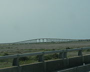
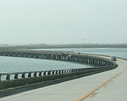
from Pea Island, which are connected by a 2.5 mile bridge that spans the inlet. As one of the few access points to the ocean along this stretch of coast, Oregon Inlet is a major departure point for charter fishing trips, with a nearby harbor serving as the base for many large boats that travel miles out towards the Gulf Stream
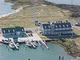
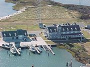
almost every day. The area is also home to a U.S. Coast Guard station.
was named the Oregon. After the storm the crew members of this ship were the first to tell those on the mainland about the inlet's formation. Hence, it has been known as Oregon Inlet ever since.
Akin to many other inlets along the Outer Banks, Oregon Inlet moves southward due to drifting sands during tides and storms. It has moved south over two miles since 1846, averaging around 66 feet per year.
 The Coast Guard station at Oregon Inlet is currently located at its fourth site since it began as a lifesaving station in 1883. It was one of 29 lifesaving stations Congress approved and appropriated funds for a decade earlier. By 1888, the Oregon Inlet Station had to be relocated to a new site. It is assumed that this relocation was necessary because of the shifting of the channel to the south and the encroachment of the ocean from the east. The station was decommissioned and moved to a new safer location some 400 feet westward toward the sound.
Less than a decade later a storm totally destroyed the Oregon Inlet Station. By 1897, a new station was under construction and was completed in 1898 for less than $7,000. As part of a modernization program in 1933-34, the Oregon Inlet Station was extensively modified to look very much like it does today. In 1979, a new extension was added. By 1988, the station was completely abandoned when the southward migration of the Oregon Inlet threatened to swallow it.
In July 1990, a ceremonial ground breaking was held for a new $3.5 million building, located just behind the Oregon Inlet Fishing Center, on the north side of the inlet. The new station was designed with the traditional architectural design of older stations located on the Outer Banks in mind.
 Oregon Inlet is spanned by North Carolina Route 12
over the Herbert C. Bonner Bridge, built in 1963. The environment’s impact on the bridge and road was not fully understood at the time of construction, and now constant beach erosion, severe weather and high volume of traffic continually forces the state to protect the integrity of the road system. As much as $50 million was spent between 1987 and 1999 to repair and protect the Bonner Bridge and NC 12 from the ocean.
The bridge was only intended to last 30 years when it was built. It handles about 2 million cars per year and the state DOT ranks it a 2 on a scale of 1 to 100, with 100 being the safest.
In October 1990, a dredge collided with the bridge during a storm, causing severe damage to several of the spans. While isolated, Hatteras Island
could only be accessed by boat or plane for many weeks while emergency construction was underway to replace its only highway link to the mainland.
Plans are in place for a replacement bridge over Oregon Inlet that connects with Pea Island and lies within the Cape Hatteras National Seashore
. Once a final alignment is chosen, construction of the new bridge, which will be longer and curve farther inland, will begin. It will cost approximately $1.3 billion and should by completed by 2014, although it is likely to be later.
Inlet
An inlet is a narrow body of water between islands or leading inland from a larger body of water, often leading to an enclosed body of water, such as a sound, bay, lagoon or marsh. In sea coasts an inlet usually refers to the actual connection between a bay and the ocean and is often called an...
along North Carolina
North Carolina
North Carolina is a state located in the southeastern United States. The state borders South Carolina and Georgia to the south, Tennessee to the west and Virginia to the north. North Carolina contains 100 counties. Its capital is Raleigh, and its largest city is Charlotte...
's Outer Banks
Outer Banks
The Outer Banks is a 200-mile long string of narrow barrier islands off the coast of North Carolina, beginning in the southeastern corner of Virginia Beach on the east coast of the United States....
. It joins the Pamlico Sound
Pamlico Sound
Pamlico Sound in North Carolina, is the largest lagoon along the U.S. East Coast, being long and 24 to 48 km wide. It is a body of water separated from the Atlantic Ocean by the Outer Banks, a row of low, sandy barrier islands, including Cape Hatteras. The Neuse and Pamlico rivers flow in...
with the Atlantic Ocean
Atlantic Ocean
The Atlantic Ocean is the second-largest of the world's oceanic divisions. With a total area of about , it covers approximately 20% of the Earth's surface and about 26% of its water surface area...
and separates Bodie Island
Bodie Island
Bodie Island is a long, narrow barrier peninsula that forms the northernmost portion of the Outer Banks of North Carolina. The land that is most commonly referred to as Bodie Island was at one time a true island, however the inlet separating it from the Currituck Banks peninsula in the north closed...
from Pea Island, which are connected by a 2.5 mile bridge that spans the inlet. As one of the few access points to the ocean along this stretch of coast, Oregon Inlet is a major departure point for charter fishing trips, with a nearby harbor serving as the base for many large boats that travel miles out towards the Gulf Stream
Gulf Stream
The Gulf Stream, together with its northern extension towards Europe, the North Atlantic Drift, is a powerful, warm, and swift Atlantic ocean current that originates at the tip of Florida, and follows the eastern coastlines of the United States and Newfoundland before crossing the Atlantic Ocean...
almost every day. The area is also home to a U.S. Coast Guard station.
History
Oregon Inlet was formed when a hurricane lashed the Outer Banks in 1846, separating Bodie Island from Pea Island. One ship that rode out that storm in Pamlico SoundPamlico Sound
Pamlico Sound in North Carolina, is the largest lagoon along the U.S. East Coast, being long and 24 to 48 km wide. It is a body of water separated from the Atlantic Ocean by the Outer Banks, a row of low, sandy barrier islands, including Cape Hatteras. The Neuse and Pamlico rivers flow in...
was named the Oregon. After the storm the crew members of this ship were the first to tell those on the mainland about the inlet's formation. Hence, it has been known as Oregon Inlet ever since.
Akin to many other inlets along the Outer Banks, Oregon Inlet moves southward due to drifting sands during tides and storms. It has moved south over two miles since 1846, averaging around 66 feet per year.
Coast Guard station
Less than a decade later a storm totally destroyed the Oregon Inlet Station. By 1897, a new station was under construction and was completed in 1898 for less than $7,000. As part of a modernization program in 1933-34, the Oregon Inlet Station was extensively modified to look very much like it does today. In 1979, a new extension was added. By 1988, the station was completely abandoned when the southward migration of the Oregon Inlet threatened to swallow it.
In July 1990, a ceremonial ground breaking was held for a new $3.5 million building, located just behind the Oregon Inlet Fishing Center, on the north side of the inlet. The new station was designed with the traditional architectural design of older stations located on the Outer Banks in mind.
Herbert C. Bonner Bridge
North Carolina State Highway 12
NC 12 is a North Carolina state highway that traverses the northeastern shoreline of North Carolina, linking the islands of the Outer Banks. It is a popular route for visitors touring the Outer Banks...
over the Herbert C. Bonner Bridge, built in 1963. The environment’s impact on the bridge and road was not fully understood at the time of construction, and now constant beach erosion, severe weather and high volume of traffic continually forces the state to protect the integrity of the road system. As much as $50 million was spent between 1987 and 1999 to repair and protect the Bonner Bridge and NC 12 from the ocean.
The bridge was only intended to last 30 years when it was built. It handles about 2 million cars per year and the state DOT ranks it a 2 on a scale of 1 to 100, with 100 being the safest.
In October 1990, a dredge collided with the bridge during a storm, causing severe damage to several of the spans. While isolated, Hatteras Island
Hatteras Island
Hatteras Island is a barrier island located off the North Carolina coast. Dividing the Atlantic Ocean and the Pamlico Sound, it runs parallel to the coast, forming a bend at Cape Hatteras. It is part of North Carolina's Outer Banks and includes the towns of Rodanthe, Waves, Salvo, Avon, Buxton,...
could only be accessed by boat or plane for many weeks while emergency construction was underway to replace its only highway link to the mainland.
Plans are in place for a replacement bridge over Oregon Inlet that connects with Pea Island and lies within the Cape Hatteras National Seashore
Cape Hatteras National Seashore
Cape Hatteras National Seashore preserves the portion of the Outer Banks of North Carolina from Bodie Island to Ocracoke Island, stretching over . Included within this section of barrier islands along N.C...
. Once a final alignment is chosen, construction of the new bridge, which will be longer and curve farther inland, will begin. It will cost approximately $1.3 billion and should by completed by 2014, although it is likely to be later.