
1935 Atlantic hurricane season
Encyclopedia
The 1935 Atlantic hurricane season ran from June 16 through October 31, 1935. The 1935 season
featured below average activity, but it was eventful. A Category 1
hurricane in the Caribbean
killed an estimated 2,150 people in the Greater Antilles
and Central America
. A Category 3
storm hit central Cuba
and grazed Miami
. An extratropical
hurricane hit Newfoundland. The second tropical cyclone of the season struck the Florida Keys
in southern Florida as a Category 5 hurricane; it remains the strongest landfalling hurricane in the United States (and anywhere in the Atlantic basin). A rare November hurricane also affected the Miami
—Fort Lauderdale
area.
hurricane the following day. On August 20, the system began to curve northward and later north-northeast, and the hurricane reached its peak of 120 miles per hour (193.1 km/h) on August 22. The hurricane later passed just west of Bermuda
late on August 22 as a slightly weaker 115 miles per hour (185.1 km/h) hurricane. On August 24, the hurricane weakened to a Category 2 hurricane and began to turn more to the north. Continuing to curve northwestward on August 25, the hurricane continued to weaken to a Category 1 hurricane, later striking Newfoundland as an extratropical
storm on August 26. The storm later dissipated on the same day.
on September 2. The storm was first detected as a disturbance east of the Bahamas. It strengthened very rapidly as it moved across the Straits of Florida
. It made landfall on Craig Key
in the Upper Keys as a small but intense Category 5
major hurricane. A pressure reading of 892 millibars (26.35 inHg
) was recorded near where the center crossed the islands. The pressure reading makes the Labor Day Hurricane the most intense to ever strike the U.S. It ranks third on the list of the most intense Atlantic hurricanes based on lowest pressure, behind only Hurricane Gilbert
of 1988
, which did not strike the U.S., and Wilma
of 2005
.
After crossing the Keys, the storm proceeded up the Florida
west coast, bringing flooding rains all along the way. The storm made its final landfall on the sparsely populated Apalachee
coast near Cedar Key
on September 5. It moved inland and then curved back out to sea and later dissipated in the North Atlantic
on September 10. More than 400 people were killed in the Keys and the damage in the area of landfall was catastrophic. Portions of the Florida East Coast Railway
in the Upper Keys were severely damaged or destroyed. The hurricane also washed an evacuation train off the tracks and many who were awaiting rescue, including World War I
veterans who were living and working in the Keys as part of a government relief project, were killed.
on August 31. The tropical cyclone strengthened to its peak with winds of 40 miles per hour (64.4 km/h) over the Bay of Campeche
. The system eventually weakened to a depression on September 1 shortly before making landfall in mainland Mexico. The system weakened after moving inland and dissipated later on the same day.
south-southeast of Jamaica
on September 23. Moving westward, the system strengthened into a hurricane on September 24 and later a Category 2
hurricane on September 26 while beginning to curve northward. The hurricane continued to strengthen while slowly moving northward, strengthening to its peak of 120 miles per hour (193.1 km/h) as a major hurricane on September 28. The hurricane struck Cuba at its peak intensity shortly thereafter, and it maintained intensity while entering the Straits of Florida
on September 29. While beginning to turn northeast, the hurricane passed over the Bahamas shortly thereafter as a 115 miles per hour (185.1 km/h) Category 3
hurricane, eventually weakening to a Category 2 hurricane on September 30 while accelerating away from the United States mainland. The hurricane passed near Bermuda on October 1, later weakening to a Category 1
hurricane and becoming extratropical the following day. The storm caused great destruction across Cuba and the Bahamas, killing 50 people (mostly in floods). Bimini
was swamped by a 15 feet (4.6 m) storm surge that destroyed most of the buildings on the island, and winds were estimated near 120 miles per hour (193.1 km/h).
with winds of 40 miles per hour (64.4 km/h). Moving slowly north-northeast, the system strengthened quickly into a hurricane on October 20, and it attained its first peak intensity of 85 miles per hour (136.8 km/h) just south-southeast of Kingston
. The hurricane slowed on October 22 just east of Jamaica. Later, the hurricane made landfall near Santiago de Cuba
early on October 23. Continuing to turn southwest on October 23, the system weakened to a 60 miles per hour (96.6 km/h) tropical storm in the western Caribbean. The system began to reintensify shortly thereafter, regaining hurricane status late on October 24 and regaining a second peak intensity of 65 miles per hour (104.6 km/h) on October 25. On October 26, it made landfall in Nicaragua
as a Category 1 hurricane. The hurricane maintained intensity after moving inland before weakening to a tropical storm on October 26, eventually weakening to a tropical depression on October 27 over interior Central America
. The system dissipated shortly thereafter. This storm caused catastrophic flooding that killed roughly 2,150 people in Haiti and Central America and caused upwards of $2 million in damages (1935 dollars).
area, this storm began as a tropical storm near Bermuda on October 30. Moving westward, the storm strengthened to a 75 miles per hour (120.7 km/h) Category 1 hurricane on November 1 while initially threatening the North Carolina
coastline. The system began to turn southwest on November 2, however, while continuing to strengthen to its peak of 80 miles per hour (128.7 km/h), while a ship recorded a minimal pressure of 980 mbar. The hurricane continued moving slowly south-southwest while weakening slightly, eventually making landfall near Miami Beach, Florida
, as a 75 miles per hour (120.7 km/h) minimal hurricane on November 4 with a measured pressure of 973 mbar at landfall. The system crossed the southern end of the Florida peninsula
shortly thereafter, eventually entering the southeast Gulf of Mexico
as a minimal hurricane near the Dry Tortugas
on November 5. The hurricane then weakened into a tropical storm while beginning a slow clockwise loop in the eastern Gulf
, eventually curving back east while weakening to a depression just west of St. Petersburg
late on November 7. The system dissipated just offshore on November 8. It had killed 19 people and caused upwards of $5.5 million in uninflated damage. The hurricane's unusual approach toward Florida and late arrival earned it the nickname of the Yankee Hurricane.
Atlantic hurricane season
The Atlantic hurricane season is the period in a year when hurricanes usually form in the Atlantic Ocean. Tropical cyclones in the North Atlantic are called hurricanes, tropical storms, or tropical depressions. In addition, there have been several storms over the years that have not been fully...
featured below average activity, but it was eventful. A Category 1
Saffir-Simpson Hurricane Scale
The Saffir–Simpson Hurricane Scale , or the Saffir–Simpson Hurricane Wind Scale , classifies hurricanes — Western Hemisphere tropical cyclones that exceed the intensities of tropical depressions and tropical storms — into five categories distinguished by the intensities of their sustained winds...
hurricane in the Caribbean
Caribbean
The Caribbean is a crescent-shaped group of islands more than 2,000 miles long separating the Gulf of Mexico and the Caribbean Sea, to the west and south, from the Atlantic Ocean, to the east and north...
killed an estimated 2,150 people in the Greater Antilles
Greater Antilles
The Greater Antilles are one of three island groups in the Caribbean. Comprising Cuba, Jamaica, Hispaniola , and Puerto Rico, the Greater Antilles constitute almost 90% of the land mass of the entire West Indies.-Greater Antilles in context :The islands of the Caribbean Sea, collectively known as...
and Central America
Central America
Central America is the central geographic region of the Americas. It is the southernmost, isthmian portion of the North American continent, which connects with South America on the southeast. When considered part of the unified continental model, it is considered a subcontinent...
. A Category 3
Saffir-Simpson Hurricane Scale
The Saffir–Simpson Hurricane Scale , or the Saffir–Simpson Hurricane Wind Scale , classifies hurricanes — Western Hemisphere tropical cyclones that exceed the intensities of tropical depressions and tropical storms — into five categories distinguished by the intensities of their sustained winds...
storm hit central Cuba
Cuba
The Republic of Cuba is an island nation in the Caribbean. The nation of Cuba consists of the main island of Cuba, the Isla de la Juventud, and several archipelagos. Havana is the largest city in Cuba and the country's capital. Santiago de Cuba is the second largest city...
and grazed Miami
Miami, Florida
Miami is a city located on the Atlantic coast in southeastern Florida and the county seat of Miami-Dade County, the most populous county in Florida and the eighth-most populous county in the United States with a population of 2,500,625...
. An extratropical
Extratropical cyclone
Extratropical cyclones, sometimes called mid-latitude cyclones or wave cyclones, are a group of cyclones defined as synoptic scale low pressure weather systems that occur in the middle latitudes of the Earth having neither tropical nor polar characteristics, and are connected with fronts and...
hurricane hit Newfoundland. The second tropical cyclone of the season struck the Florida Keys
Florida Keys
The Florida Keys are a coral archipelago in southeast United States. They begin at the southeastern tip of the Florida peninsula, about south of Miami, and extend in a gentle arc south-southwest and then westward to Key West, the westernmost of the inhabited islands, and on to the uninhabited Dry...
in southern Florida as a Category 5 hurricane; it remains the strongest landfalling hurricane in the United States (and anywhere in the Atlantic basin). A rare November hurricane also affected the Miami
Miami, Florida
Miami is a city located on the Atlantic coast in southeastern Florida and the county seat of Miami-Dade County, the most populous county in Florida and the eighth-most populous county in the United States with a population of 2,500,625...
—Fort Lauderdale
Fort Lauderdale, Florida
Fort Lauderdale is a city in the U.S. state of Florida, on the Atlantic coast. It is the county seat of Broward County. As of the 2010 census, the city had a population of 165,521. It is a principal city of the South Florida metropolitan area, which was home to 5,564,635 people at the 2010...
area.
Hurricane One
A hurricane was detected near the Leeward Islands on August 18. Moving west-northwest, the storm gradually intensified into a Category 2Saffir-Simpson Hurricane Scale
The Saffir–Simpson Hurricane Scale , or the Saffir–Simpson Hurricane Wind Scale , classifies hurricanes — Western Hemisphere tropical cyclones that exceed the intensities of tropical depressions and tropical storms — into five categories distinguished by the intensities of their sustained winds...
hurricane the following day. On August 20, the system began to curve northward and later north-northeast, and the hurricane reached its peak of 120 miles per hour (193.1 km/h) on August 22. The hurricane later passed just west of Bermuda
Bermuda
Bermuda is a British overseas territory in the North Atlantic Ocean. Located off the east coast of the United States, its nearest landmass is Cape Hatteras, North Carolina, about to the west-northwest. It is about south of Halifax, Nova Scotia, Canada, and northeast of Miami, Florida...
late on August 22 as a slightly weaker 115 miles per hour (185.1 km/h) hurricane. On August 24, the hurricane weakened to a Category 2 hurricane and began to turn more to the north. Continuing to curve northwestward on August 25, the hurricane continued to weaken to a Category 1 hurricane, later striking Newfoundland as an extratropical
Extratropical cyclone
Extratropical cyclones, sometimes called mid-latitude cyclones or wave cyclones, are a group of cyclones defined as synoptic scale low pressure weather systems that occur in the middle latitudes of the Earth having neither tropical nor polar characteristics, and are connected with fronts and...
storm on August 26. The storm later dissipated on the same day.
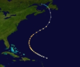
Hurricane Two
By far the most notable storm of the season was the Labor Day Hurricane that made landfall in the Florida KeysFlorida Keys
The Florida Keys are a coral archipelago in southeast United States. They begin at the southeastern tip of the Florida peninsula, about south of Miami, and extend in a gentle arc south-southwest and then westward to Key West, the westernmost of the inhabited islands, and on to the uninhabited Dry...
on September 2. The storm was first detected as a disturbance east of the Bahamas. It strengthened very rapidly as it moved across the Straits of Florida
Straits of Florida
The Straits of Florida, Florida Straits, or Florida Strait is a strait located south-southeast of the North American mainland, generally accepted to be between the Gulf of Mexico and the Atlantic Ocean, and between the Florida Keys and Cuba. The strait carries the Florida Current, the beginning of...
. It made landfall on Craig Key
Craig Key
Craig Key is an island in the middle Florida Keys.U.S. 1 crosses the key at approximately mile marker 72, between Lower Matecumbe Key and Fiesta Key.-History:...
in the Upper Keys as a small but intense Category 5
Saffir-Simpson Hurricane Scale
The Saffir–Simpson Hurricane Scale , or the Saffir–Simpson Hurricane Wind Scale , classifies hurricanes — Western Hemisphere tropical cyclones that exceed the intensities of tropical depressions and tropical storms — into five categories distinguished by the intensities of their sustained winds...
major hurricane. A pressure reading of 892 millibars (26.35 inHg
Pascal (unit)
The pascal is the SI derived unit of pressure, internal pressure, stress, Young's modulus and tensile strength, named after the French mathematician, physicist, inventor, writer, and philosopher Blaise Pascal. It is a measure of force per unit area, defined as one newton per square metre...
) was recorded near where the center crossed the islands. The pressure reading makes the Labor Day Hurricane the most intense to ever strike the U.S. It ranks third on the list of the most intense Atlantic hurricanes based on lowest pressure, behind only Hurricane Gilbert
Hurricane Gilbert
Hurricane Gilbert was an extremely powerful Cape Verde-type hurricane that formed during the 1988 Atlantic hurricane season and created widespread destruction in the Caribbean Sea and the Gulf of Mexico. It is the second most intense hurricane ever observed in the Atlantic basin behind only...
of 1988
1988 Atlantic hurricane season
The 1988 Atlantic hurricane season was a moderately active season that proved costly and deadly, with 15 tropical cyclones directly affecting land. The season officially began on June 1, 1988, and lasted until November 30, 1988, although activity began on May 30 when a tropical...
, which did not strike the U.S., and Wilma
Hurricane Wilma
Hurricane Wilma was the most intense tropical cyclone ever recorded in the Atlantic basin. Wilma was the twenty-second storm , thirteenth hurricane, sixth major hurricane, and fourth Category 5 hurricane of the record-breaking 2005 season...
of 2005
2005 Atlantic hurricane season
The 2005 Atlantic hurricane season was the most active Atlantic hurricane season in recorded history, repeatedly shattering numerous records. The impact of the season was widespread and ruinous with an estimated 3,913 deaths and record damage of about $159.2 billion...
.
After crossing the Keys, the storm proceeded up the Florida
Florida
Florida is a state in the southeastern United States, located on the nation's Atlantic and Gulf coasts. It is bordered to the west by the Gulf of Mexico, to the north by Alabama and Georgia and to the east by the Atlantic Ocean. With a population of 18,801,310 as measured by the 2010 census, it...
west coast, bringing flooding rains all along the way. The storm made its final landfall on the sparsely populated Apalachee
Big Bend (Florida)
The Big Bend of Florida, U.S.A., is an informal region of the state with no official surveyed boundary. It includes part of the counties of the Florida Panhandle. Geologists prefer to characterize Florida’s Big Bend as the drowned karst section of the coast that occurs between the mouth of the...
coast near Cedar Key
Cedar Key, Florida
Cedar Key is a city in Levy County, Florida, United States. The population was 790 at the 2000 census. According to the U.S Census estimates of 2005, the city had a population of 958. The Cedar Keys are a cluster of islands close to the mainland. Most of the developed area of the city has been on...
on September 5. It moved inland and then curved back out to sea and later dissipated in the North Atlantic
Atlantic Ocean
The Atlantic Ocean is the second-largest of the world's oceanic divisions. With a total area of about , it covers approximately 20% of the Earth's surface and about 26% of its water surface area...
on September 10. More than 400 people were killed in the Keys and the damage in the area of landfall was catastrophic. Portions of the Florida East Coast Railway
Florida East Coast Railway
The Florida East Coast Railway is a Class II railroad operating in the U.S. state of Florida; in the past, it has been a Class I railroad.Built primarily in the last quarter of the 19th century and the first decade of the 20th century, the FEC was a project of Standard Oil principal Henry Morrison...
in the Upper Keys were severely damaged or destroyed. The hurricane also washed an evacuation train off the tracks and many who were awaiting rescue, including World War I
World War I
World War I , which was predominantly called the World War or the Great War from its occurrence until 1939, and the First World War or World War I thereafter, was a major war centred in Europe that began on 28 July 1914 and lasted until 11 November 1918...
veterans who were living and working in the Keys as part of a government relief project, were killed.
Tropical Storm Three
A short-lived weak tropical storm formed west of the Yucatán PeninsulaYucatán Peninsula
The Yucatán Peninsula, in southeastern Mexico, separates the Caribbean Sea from the Gulf of Mexico, with the northern coastline on the Yucatán Channel...
on August 31. The tropical cyclone strengthened to its peak with winds of 40 miles per hour (64.4 km/h) over the Bay of Campeche
Bay of Campeche
The Bay of Campeche is the southern bight of the Gulf of Mexico. It is surrounded on three sides by the Mexican states of Campeche, Tabasco and Veracruz. It was named by Francisco Hernández de Córdoba and Antonio de Alaminos during their expedition in 1517...
. The system eventually weakened to a depression on September 1 shortly before making landfall in mainland Mexico. The system weakened after moving inland and dissipated later on the same day.
Hurricane Four
A tropical storm formed in the western Caribbean SeaCaribbean Sea
The Caribbean Sea is a sea of the Atlantic Ocean located in the tropics of the Western hemisphere. It is bounded by Mexico and Central America to the west and southwest, to the north by the Greater Antilles, and to the east by the Lesser Antilles....
south-southeast of Jamaica
Jamaica
Jamaica is an island nation of the Greater Antilles, in length, up to in width and 10,990 square kilometres in area. It is situated in the Caribbean Sea, about south of Cuba, and west of Hispaniola, the island harbouring the nation-states Haiti and the Dominican Republic...
on September 23. Moving westward, the system strengthened into a hurricane on September 24 and later a Category 2
Saffir-Simpson Hurricane Scale
The Saffir–Simpson Hurricane Scale , or the Saffir–Simpson Hurricane Wind Scale , classifies hurricanes — Western Hemisphere tropical cyclones that exceed the intensities of tropical depressions and tropical storms — into five categories distinguished by the intensities of their sustained winds...
hurricane on September 26 while beginning to curve northward. The hurricane continued to strengthen while slowly moving northward, strengthening to its peak of 120 miles per hour (193.1 km/h) as a major hurricane on September 28. The hurricane struck Cuba at its peak intensity shortly thereafter, and it maintained intensity while entering the Straits of Florida
Straits of Florida
The Straits of Florida, Florida Straits, or Florida Strait is a strait located south-southeast of the North American mainland, generally accepted to be between the Gulf of Mexico and the Atlantic Ocean, and between the Florida Keys and Cuba. The strait carries the Florida Current, the beginning of...
on September 29. While beginning to turn northeast, the hurricane passed over the Bahamas shortly thereafter as a 115 miles per hour (185.1 km/h) Category 3
Saffir-Simpson Hurricane Scale
The Saffir–Simpson Hurricane Scale , or the Saffir–Simpson Hurricane Wind Scale , classifies hurricanes — Western Hemisphere tropical cyclones that exceed the intensities of tropical depressions and tropical storms — into five categories distinguished by the intensities of their sustained winds...
hurricane, eventually weakening to a Category 2 hurricane on September 30 while accelerating away from the United States mainland. The hurricane passed near Bermuda on October 1, later weakening to a Category 1
Saffir-Simpson Hurricane Scale
The Saffir–Simpson Hurricane Scale , or the Saffir–Simpson Hurricane Wind Scale , classifies hurricanes — Western Hemisphere tropical cyclones that exceed the intensities of tropical depressions and tropical storms — into five categories distinguished by the intensities of their sustained winds...
hurricane and becoming extratropical the following day. The storm caused great destruction across Cuba and the Bahamas, killing 50 people (mostly in floods). Bimini
Bimini
Bimini is the westernmost district of the Bahamas composed of a chain of islands located about 53 miles due east of Miami, Florida. Bimini is the closest point in the Bahamas to the mainland United States and approximately 137 miles west-northwest of Nassau...
was swamped by a 15 feet (4.6 m) storm surge that destroyed most of the buildings on the island, and winds were estimated near 120 miles per hour (193.1 km/h).
Hurricane Five
A tropical storm formed late in the season on October 18 in the south-central Caribbean SeaCaribbean Sea
The Caribbean Sea is a sea of the Atlantic Ocean located in the tropics of the Western hemisphere. It is bounded by Mexico and Central America to the west and southwest, to the north by the Greater Antilles, and to the east by the Lesser Antilles....
with winds of 40 miles per hour (64.4 km/h). Moving slowly north-northeast, the system strengthened quickly into a hurricane on October 20, and it attained its first peak intensity of 85 miles per hour (136.8 km/h) just south-southeast of Kingston
Kingston, Jamaica
Kingston is the capital and largest city of Jamaica, located on the southeastern coast of the island. It faces a natural harbour protected by the Palisadoes, a long sand spit which connects the town of Port Royal and the Norman Manley International Airport to the rest of the island...
. The hurricane slowed on October 22 just east of Jamaica. Later, the hurricane made landfall near Santiago de Cuba
Santiago de Cuba
Santiago de Cuba is the second largest city of Cuba and capital city of Santiago de Cuba Province in the south-eastern area of the island, some south-east of the Cuban capital of Havana....
early on October 23. Continuing to turn southwest on October 23, the system weakened to a 60 miles per hour (96.6 km/h) tropical storm in the western Caribbean. The system began to reintensify shortly thereafter, regaining hurricane status late on October 24 and regaining a second peak intensity of 65 miles per hour (104.6 km/h) on October 25. On October 26, it made landfall in Nicaragua
Nicaragua
Nicaragua is the largest country in the Central American American isthmus, bordered by Honduras to the north and Costa Rica to the south. The country is situated between 11 and 14 degrees north of the Equator in the Northern Hemisphere, which places it entirely within the tropics. The Pacific Ocean...
as a Category 1 hurricane. The hurricane maintained intensity after moving inland before weakening to a tropical storm on October 26, eventually weakening to a tropical depression on October 27 over interior Central America
Central America
Central America is the central geographic region of the Americas. It is the southernmost, isthmian portion of the North American continent, which connects with South America on the southeast. When considered part of the unified continental model, it is considered a subcontinent...
. The system dissipated shortly thereafter. This storm caused catastrophic flooding that killed roughly 2,150 people in Haiti and Central America and caused upwards of $2 million in damages (1935 dollars).
Hurricane Six
A rare early November hurricane strike in the MiamiMiami, Florida
Miami is a city located on the Atlantic coast in southeastern Florida and the county seat of Miami-Dade County, the most populous county in Florida and the eighth-most populous county in the United States with a population of 2,500,625...
area, this storm began as a tropical storm near Bermuda on October 30. Moving westward, the storm strengthened to a 75 miles per hour (120.7 km/h) Category 1 hurricane on November 1 while initially threatening the North Carolina
North Carolina
North Carolina is a state located in the southeastern United States. The state borders South Carolina and Georgia to the south, Tennessee to the west and Virginia to the north. North Carolina contains 100 counties. Its capital is Raleigh, and its largest city is Charlotte...
coastline. The system began to turn southwest on November 2, however, while continuing to strengthen to its peak of 80 miles per hour (128.7 km/h), while a ship recorded a minimal pressure of 980 mbar. The hurricane continued moving slowly south-southwest while weakening slightly, eventually making landfall near Miami Beach, Florida
Miami Beach, Florida
Miami Beach is a coastal resort city in Miami-Dade County, Florida, United States, incorporated on March 26, 1915. The municipality is located on a barrier island between the Atlantic Ocean and Biscayne Bay, the latter which separates the Beach from Miami city proper...
, as a 75 miles per hour (120.7 km/h) minimal hurricane on November 4 with a measured pressure of 973 mbar at landfall. The system crossed the southern end of the Florida peninsula
Florida
Florida is a state in the southeastern United States, located on the nation's Atlantic and Gulf coasts. It is bordered to the west by the Gulf of Mexico, to the north by Alabama and Georgia and to the east by the Atlantic Ocean. With a population of 18,801,310 as measured by the 2010 census, it...
shortly thereafter, eventually entering the southeast Gulf of Mexico
Gulf of Mexico
The Gulf of Mexico is a partially landlocked ocean basin largely surrounded by the North American continent and the island of Cuba. It is bounded on the northeast, north and northwest by the Gulf Coast of the United States, on the southwest and south by Mexico, and on the southeast by Cuba. In...
as a minimal hurricane near the Dry Tortugas
Dry Tortugas
The Dry Tortugas are a small group of islands, located at the end of the Florida Keys, USA, about west of Key West, and west of the Marquesas Keys, the closest islands. Still further west is the Tortugas Bank, which is completely submerged. The first Europeans to discover the islands were the...
on November 5. The hurricane then weakened into a tropical storm while beginning a slow clockwise loop in the eastern Gulf
Gulf of Mexico
The Gulf of Mexico is a partially landlocked ocean basin largely surrounded by the North American continent and the island of Cuba. It is bounded on the northeast, north and northwest by the Gulf Coast of the United States, on the southwest and south by Mexico, and on the southeast by Cuba. In...
, eventually curving back east while weakening to a depression just west of St. Petersburg
St. Petersburg, Florida
St. Petersburg is a city in Pinellas County, Florida, United States. It is known as a vacation destination for both American and foreign tourists. As of 2008, the population estimate by the U.S. Census Bureau is 245,314, making St...
late on November 7. The system dissipated just offshore on November 8. It had killed 19 people and caused upwards of $5.5 million in uninflated damage. The hurricane's unusual approach toward Florida and late arrival earned it the nickname of the Yankee Hurricane.
See also
- List of tropical cyclones
- List of Atlantic hurricane seasons