
1917 Atlantic hurricane season
Encyclopedia
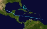
The 1917 Atlantic hurricane season ran through the summer and the first half of fall in 1917. It was an inactive season. Only four tropical cyclones formed this season. Two of them were hurricanes; the other was a tropical storm that stayed out to sea. The first Atlantic hurricane stayed largely out to sea. It passed about a dozen miles off Bermuda
but did little else. The second hurricane
was the most destructive. It kept close to the islands of the Greater Antilles
, passing over Cuba
as a strong Category 4
hurricane. After moving into the Gulf of Mexico
, it swerved northeast toward the Florida Panhandle
. It hit near Fort Walton Beach
as a Category 3 hurricane and dissipated inland. The hurricane killed five people and caused $170,000 in damage in the United States
.
and attained peak winds of 50 mph (80 km/h) in the Caribbean Sea
on July 8. Later, it weakened on July 9, and it degenerated into an area of low pressure
prior to hitting Honduras
. It transversed the Bay of Campeche
, crossing the coast near Tampico, Tamaulipas and dissipating on July 14. Originally, it was not recorded until the Atlantic hurricane reanalysis
project added the system to the Atlantic hurricane database.
, though it produced sustained winds of 65 mph (105 km/h) at Nantucket Shoals Light. Four fishing vessels disappeared during the storm. It moved over Newfoundland as an extratropical cyclone
on August 11.
. It was likely a Cape Verde-type hurricane
, but evidence is inconclusive because of scarce observations in the eastern Atlantic Ocean. It intensified to a hurricane on August 31, moving west-northwest through the North Atlantic. It remained north of the Lesser Antilles, and it intensified to peak winds of 120 mph (190 km/h) on September 4. It passed within 120 miles (195 km) of Hamilton, Bermuda
, and it transitioned to an extratropical storm on September 6. The maximum winds of the storm are estimated, though high waves at Bermuda suggested that the cyclone reached major hurricane strength on the Saffir-Simpson Hurricane Scale.
on September 20. It strengthened to a peak intensity of 150 mph (240 km/h) prior to landfall in Cuba on September 25. Later, it struck the Florida Panhandle east of Pensacola, Florida on September 29. It was the most intense hurricane in northwest Florida until Hurricane Opal
in 1995.
Bermuda
Bermuda is a British overseas territory in the North Atlantic Ocean. Located off the east coast of the United States, its nearest landmass is Cape Hatteras, North Carolina, about to the west-northwest. It is about south of Halifax, Nova Scotia, Canada, and northeast of Miami, Florida...
but did little else. The second hurricane
1917 Pinar del Río hurricane
The 1917 Nueva Gerona hurricane was the strongest Atlantic hurricane of the 1917 Atlantic hurricane season. The fourth tropical cyclone, second hurricane, and the second major hurricane of the season, it developed east-southeast of Martinique. It moved west-northwest, passing between Saint Lucia...
was the most destructive. It kept close to the islands of the Greater Antilles
Greater Antilles
The Greater Antilles are one of three island groups in the Caribbean. Comprising Cuba, Jamaica, Hispaniola , and Puerto Rico, the Greater Antilles constitute almost 90% of the land mass of the entire West Indies.-Greater Antilles in context :The islands of the Caribbean Sea, collectively known as...
, passing over Cuba
Cuba
The Republic of Cuba is an island nation in the Caribbean. The nation of Cuba consists of the main island of Cuba, the Isla de la Juventud, and several archipelagos. Havana is the largest city in Cuba and the country's capital. Santiago de Cuba is the second largest city...
as a strong Category 4
Saffir-Simpson Hurricane Scale
The Saffir–Simpson Hurricane Scale , or the Saffir–Simpson Hurricane Wind Scale , classifies hurricanes — Western Hemisphere tropical cyclones that exceed the intensities of tropical depressions and tropical storms — into five categories distinguished by the intensities of their sustained winds...
hurricane. After moving into the Gulf of Mexico
Gulf of Mexico
The Gulf of Mexico is a partially landlocked ocean basin largely surrounded by the North American continent and the island of Cuba. It is bounded on the northeast, north and northwest by the Gulf Coast of the United States, on the southwest and south by Mexico, and on the southeast by Cuba. In...
, it swerved northeast toward the Florida Panhandle
Florida Panhandle
The Florida Panhandle, an informal, unofficial term for the northwestern part of Florida, is a strip of land roughly 200 miles long and 50 to 100 miles wide , lying between Alabama on the north and the west, Georgia also on the north, and the Gulf of Mexico to the south. Its eastern boundary is...
. It hit near Fort Walton Beach
Fort Walton Beach, Florida
Fort Walton Beach is a city in southern Okaloosa County, Florida, United States. As of 2005, the population estimate for Fort Walton Beach was 19,992, and as of 2010, the population estimate for Fort Walton Beach is 19,507 recorded by the U.S. Census Bureau...
as a Category 3 hurricane and dissipated inland. The hurricane killed five people and caused $170,000 in damage in the United States
United States
The United States of America is a federal constitutional republic comprising fifty states and a federal district...
.
Tropical Storm One
On July 6, a tropical depression formed near the island of Barbados. It strengthened to a tropical stormTropical cyclone scales
Tropical systems are officially ranked on one of several tropical cyclone scales according to their maximum sustained winds and in what oceanic basin they are located...
and attained peak winds of 50 mph (80 km/h) in the Caribbean Sea
Caribbean Sea
The Caribbean Sea is a sea of the Atlantic Ocean located in the tropics of the Western hemisphere. It is bounded by Mexico and Central America to the west and southwest, to the north by the Greater Antilles, and to the east by the Lesser Antilles....
on July 8. Later, it weakened on July 9, and it degenerated into an area of low pressure
Low pressure area
A low-pressure area, or "low", is a region where the atmospheric pressure at sea level is below that of surrounding locations. Low-pressure systems form under areas of wind divergence which occur in upper levels of the troposphere. The formation process of a low-pressure area is known as...
prior to hitting Honduras
Honduras
Honduras is a republic in Central America. It was previously known as Spanish Honduras to differentiate it from British Honduras, which became the modern-day state of Belize...
. It transversed the Bay of Campeche
Bay of Campeche
The Bay of Campeche is the southern bight of the Gulf of Mexico. It is surrounded on three sides by the Mexican states of Campeche, Tabasco and Veracruz. It was named by Francisco Hernández de Córdoba and Antonio de Alaminos during their expedition in 1517...
, crossing the coast near Tampico, Tamaulipas and dissipating on July 14. Originally, it was not recorded until the Atlantic hurricane reanalysis
Atlantic hurricane reanalysis
Atlantic hurricane reanalysis is an ongoing project within the National Oceanic and Atmospheric Administration which seeks to correct and add new information about past Atlantic tropical cyclones...
project added the system to the Atlantic hurricane database.
Tropical Storm Two
This strong tropical storm remained off the East Coast of the United StatesEast Coast of the United States
The East Coast of the United States, also known as the Eastern Seaboard, refers to the easternmost coastal states in the United States, which touch the Atlantic Ocean and stretch up to Canada. The term includes the U.S...
, though it produced sustained winds of 65 mph (105 km/h) at Nantucket Shoals Light. Four fishing vessels disappeared during the storm. It moved over Newfoundland as an extratropical cyclone
Extratropical cyclone
Extratropical cyclones, sometimes called mid-latitude cyclones or wave cyclones, are a group of cyclones defined as synoptic scale low pressure weather systems that occur in the middle latitudes of the Earth having neither tropical nor polar characteristics, and are connected with fronts and...
on August 11.
Hurricane Three
On August 30, a tropical storm was detected 1,295 miles (2,085 km) east-southeast of AnguillaAnguilla
Anguilla is a British overseas territory and overseas territory of the European Union in the Caribbean. It is one of the most northerly of the Leeward Islands in the Lesser Antilles, lying east of Puerto Rico and the Virgin Islands and directly north of Saint Martin...
. It was likely a Cape Verde-type hurricane
Cape Verde-type hurricane
A Cape Verde-type hurricane is an Atlantic hurricane that develops near the Cape Verde islands, off the west coast of Africa. The average hurricane season has about two Cape Verde-type hurricanes, which are usually the largest and most intense storms of the season because they often have plenty of...
, but evidence is inconclusive because of scarce observations in the eastern Atlantic Ocean. It intensified to a hurricane on August 31, moving west-northwest through the North Atlantic. It remained north of the Lesser Antilles, and it intensified to peak winds of 120 mph (190 km/h) on September 4. It passed within 120 miles (195 km) of Hamilton, Bermuda
Hamilton, Bermuda
Hamilton is the capital of the British Overseas Territory of Bermuda. It is the territory's financial centre and a major port and tourist destination.-Geography:...
, and it transitioned to an extratropical storm on September 6. The maximum winds of the storm are estimated, though high waves at Bermuda suggested that the cyclone reached major hurricane strength on the Saffir-Simpson Hurricane Scale.
Hurricane Four
The strongest tropical cyclone of the season formed near the Windward IslandsWindward Islands
The Windward Islands are the southern islands of the Lesser Antilles, within the West Indies.-Name and geography:The Windward Islands are called such because they were more windward to sailing ships arriving in the New World than the Leeward Islands, given that the prevailing trade winds in the...
on September 20. It strengthened to a peak intensity of 150 mph (240 km/h) prior to landfall in Cuba on September 25. Later, it struck the Florida Panhandle east of Pensacola, Florida on September 29. It was the most intense hurricane in northwest Florida until Hurricane Opal
Hurricane Opal
Hurricane Opal was a Category 4 hurricane that formed in the Gulf of Mexico in September 1995.Opal was the ninth hurricane and the strongest of the abnormally active 1995 Atlantic hurricane season...
in 1995.
See also
- List of tropical cyclones
- List of Atlantic hurricane seasons