

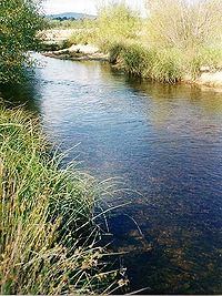
Shoalhaven River
Encyclopedia
Southern Tablelands
The Southern Tablelands is a geographic area of the State of New South Wales, Australia. This area is located west of the Great Dividing Range.The area is characterised by flat country which has generally been extensively cleared and used for grazing purposes...
and flowing into the ocean near Nowra
Nowra, New South Wales
Nowra is a city in the South Coast region of New South Wales, Australia. Located SSW and approximately by road south of the state capital of Sydney, it has an estimated population together with its twin-town of Bomaderry of 34,479. It is also the seat and commercial centre of the City of Shoalhaven...
on the South Coast
South Coast, New South Wales
The South Coast refers to the narrow coastal belt from Sydney in the north to the border with Victoria in the south in the south-eastern part of the State of New South Wales, Australia. It is bordered to the west by the coastal escarpment of the Southern Tablelands, which is largely covered by a...
of New South Wales
New South Wales
New South Wales is a state of :Australia, located in the east of the country. It is bordered by Queensland, Victoria and South Australia to the north, south and west respectively. To the east, the state is bordered by the Tasman Sea, which forms part of the Pacific Ocean. New South Wales...
, Australia
Australia
Australia , officially the Commonwealth of Australia, is a country in the Southern Hemisphere comprising the mainland of the Australian continent, the island of Tasmania, and numerous smaller islands in the Indian and Pacific Oceans. It is the world's sixth-largest country by total area...
.
History
The explorer and navigator George BassGeorge Bass
George Bass was a British naval surgeon and explorer of Australia.-Early years:He was born on 30 January 1771 at Aswarby, a hamlet near Sleaford, Lincolnshire, the son of a tenant farmer, George Bass, and a local beauty named Sarah Nee Newman. His father died in 1777 when Bass was 6...
found the entrance to the Shoalhaven River during his whaleboat voyage down the south coast of New South Wales in 1797. He gave the name Shoals Haven to the river which is now known as the Crookhaven River, due to the shoals of mud and sand he found at the mouth of the river.
Geography
The Shoalhaven rises on the eastern side of the Great Dividing RangeGreat Dividing Range
The Great Dividing Range, or the Eastern Highlands, is Australia's most substantial mountain range and the third longest in the world. The range stretches more than 3,500 km from Dauan Island off the northeastern tip of Queensland, running the entire length of the eastern coastline through...
about 350 kilometres southwest of Sydney
Sydney
Sydney is the most populous city in Australia and the state capital of New South Wales. Sydney is located on Australia's south-east coast of the Tasman Sea. As of June 2010, the greater metropolitan area had an approximate population of 4.6 million people...
. The upper reaches flow northwards through an upland pastoral district near the town of Braidwood
Braidwood, New South Wales
Braidwood is a town in the Southern Tablelands of New South Wales, Australia, in Palerang Shire. It is located on the busy Kings Highway linking Canberra to Batemans Bay on the coast. It is about 200 kilometres south west of Sydney and about 60 kilometres inland from the coast...
. The river works its way down into a remote canyon east of Goulburn
Goulburn, New South Wales
Goulburn is a provincial city in the Southern Tablelands of New South Wales, Australia in Goulburn Mulwaree Council Local Government Area. It is located south-west of Sydney on the Hume Highway and above sea-level. On Census night 2006, Goulburn had a population of 20,127 people...
and emerges into the coastal lowlands at Nowra
Nowra, New South Wales
Nowra is a city in the South Coast region of New South Wales, Australia. Located SSW and approximately by road south of the state capital of Sydney, it has an estimated population together with its twin-town of Bomaderry of 34,479. It is also the seat and commercial centre of the City of Shoalhaven...
in the Shoalhaven
Shoalhaven
The City of Shoalhaven is a Local Government Area in south-eastern New South Wales , Australia, two hours south of Sydney. It is more or less conterminous with an area referred to as The Shoalhaven. It is on the Pacific Ocean and the Princes Highway and is the terminus of the South Coast line...
district, where it is spanned by the historic Nowra Bridge
Nowra Bridge
The Nowra Bridge joins the main area of Nowra to North Nowra and Bomaderry. It carries the Princes Highway over the Shoalhaven River and was originally intended to carry a double railway track. The railway, however, was never extended past Bomaderry station where trains still terminate today...
.
Berry Canal
The estuary has two entrances, a southern one at Crookhaven Heads that is permanently open, and northern one at Shoalhaven Heads which is open intermittently during floods. The entrances are 5 km apart, and around 150 km south of SydneySydney
Sydney is the most populous city in Australia and the state capital of New South Wales. Sydney is located on Australia's south-east coast of the Tasman Sea. As of June 2010, the greater metropolitan area had an approximate population of 4.6 million people...
.
A short canal between the Shoalhaven and the Crookhaven was convict constructed in the June 1882 by a convict party overseen by Hamilton Hume
Hamilton Hume
Hamilton Hume was the first Australian born explorer. Along with Hovell in 1824, Hume was part of an expedition that first took an overland route from Sydney to Port Phillip near the site of present day Melbourne...
under the direction of Alexander Berry
Alexander Berry
Alexander Berry was a Scottish-born surgeon, merchant and explorer who in 1822 was given a land grant of 10,000 acres and 100 convicts to establish the first European settlement on the south coast of New South Wales, Australia.This settlement became known as the Coolangatta Estate and later...
to facilitate ship transport to the original European settlement there
Coolangatta Estate
The Coolangatta Estate was established in 1822 by Alexander Berry. Born on St Andrew's Day 1783, the eldest child of a tenant farming family in Fife, he studied at the University of St Andrews and Edinburgh and qualified as a surgeon...
. The construction of the canal formed Comerong Island. The canal was dug using own hand tools, and was the first land navigable canal in Australia. It remains one of two navigable canals in New South Wales, the other being the Alexandra Canal.
Use for water supply
Tallowa Dam is the only major dam on the Shoalhaven, and is a part of the Shoalhaven SchemeShoalhaven Scheme
The Shoalhaven Scheme is a dual-purpose water supply and hydro-electric power generation scheme in New South Wales. It was built as a joint project between the Electricity Commission of NSW and the NSW Metropolitan Water Sewerage and Drainage Board...
. It impounds the river's lower reaches to form Lake Yarrunga and part of Sydney's water supply. Some water is pumped out of the lake and over the Southern Highlands
Southern Highlands, New South Wales
The Southern Highlands, also locally referred to as the Highlands, is a geographical region and district in New South Wales, Australia and is 110 km south-west of Sydney. The entire region is under the local government area of the Wingecarribee Shire...
into Lake Burragorang
Lake Burragorang
Lake Burragorang is the water storage impounded by Warragamba Dam. It collects the waters of the Coxs, Kowmung, Nattai, Wingecarribee, and Wollondilly Rivers. It is the major water storage for Sydney, Australia...
. Proposals for a much larger water storage at Welcome Reef on the upper Shoalhaven have been shelved.
Environment
The Shoalhaven River and its main tributary the Kangaroo River were once renowned as an Australian bassAustralian bass
Australian bass are a small to medium sized, primarily freshwater native fish found in coastal rivers and streams along the east coast of Australia. They are a member of the Percichthyidae family and, currently, the Macquaria genus. Australian bass are an iconic, highly predatory native fish...
fishery. Unfortunately, Tallowa Dam has been a potent barrier to migratory native fish with estuarine/marine juvenile stages, blocking species including Australian bass
Australian bass
Australian bass are a small to medium sized, primarily freshwater native fish found in coastal rivers and streams along the east coast of Australia. They are a member of the Percichthyidae family and, currently, the Macquaria genus. Australian bass are an iconic, highly predatory native fish...
from more than 80% of their former range in the Shoalhaven system. Recent stockings of hatchery-bred Bass in Lake Yarrunga are an attempt to remediate the situation. A fishway for Tallowa Dam was completed in August 2009.
This fishway is designed to allow for the movement of bass and other native fish over the dam.
Lake Yarrunga has also suffered the illegal introduction of highly damaging exotic carp
Carp
Carp are various species of oily freshwater fish of the family Cyprinidae, a very large group of fish native to Europe and Asia. The cypriniformes are traditionally grouped with the Characiformes, Siluriformes and Gymnotiformes to create the superorder Ostariophysi, since these groups have certain...
, which are now present in high densities.
Crossings
The river crossings include, in order of river flow:- Warri Bridge carries the Kings Highway, near BraidwoodBraidwood, New South WalesBraidwood is a town in the Southern Tablelands of New South Wales, Australia, in Palerang Shire. It is located on the busy Kings Highway linking Canberra to Batemans Bay on the coast. It is about 200 kilometres south west of Sydney and about 60 kilometres inland from the coast...
. A bridge at this location was first opened on 23 September 1874, and later replaced by the current structure. - Stewart's Crossing is a fordFord (crossing)A ford is a shallow place with good footing where a river or stream may be crossed by wading or in a vehicle. A ford is mostly a natural phenomenon, in contrast to a low water crossing, which is an artificial bridge that allows crossing a river or stream when water is low.The names of many towns...
on Stewart's Crossing Road. - Oallen Crossing is a single lane timber bridge for the Oallen Ford Road at Oallen Ford, near NerrigaNerriga, New South WalesNerriga is a small village in the Southern Tablelands of New South Wales, Australia in Palerang Shire. It is situated at the edge of Morton National Park, on the Braidwood - Nowra road....
constructed in 1936 - Nowra BridgeNowra BridgeThe Nowra Bridge joins the main area of Nowra to North Nowra and Bomaderry. It carries the Princes Highway over the Shoalhaven River and was originally intended to carry a double railway track. The railway, however, was never extended past Bomaderry station where trains still terminate today...
carries the Princes Highway between BomaderryBomaderry, New South WalesBomaderry is a town in the Shoalhaven council district area of New South Wales, Australia. In 2006, it had a population of 6,601 people. It is on the north shore of the Shoalhaven River, across the river from Nowra, the major town of the Shoalhaven,of which Bomaderry is locally regarded as being...
and NowraNowra, New South WalesNowra is a city in the South Coast region of New South Wales, Australia. Located SSW and approximately by road south of the state capital of Sydney, it has an estimated population together with its twin-town of Bomaderry of 34,479. It is also the seat and commercial centre of the City of Shoalhaven...
. - Comerong Island Ferry carries vehicles and pedestrians to Comerong Island near the river mouth.