

Yellow Line (Washington Metro)
Encyclopedia
Washington Metro
The Washington Metro, commonly called Metro, and unofficially Metrorail, is the rapid transit system in Washington, D.C., United States, and its surrounding suburbs. It is administered by the Washington Metropolitan Area Transit Authority , which also operates Metrobus service under the Metro name...
consists of 17 rapid transit
Rapid transit
A rapid transit, underground, subway, elevated railway, metro or metropolitan railway system is an electric passenger railway in an urban area with a high capacity and frequency, and grade separation from other traffic. Rapid transit systems are typically located either in underground tunnels or on...
stations
Metro station
A metro station or subway station is a railway station for a rapid transit system, often known by names such as "metro", "underground" and "subway". It is often underground or elevated. At crossings of metro lines, they are multi-level....
from Huntington to Fort Totten. The line terminates at the Mount Vernon Square station during peak hours.Peak hours are 5 a.m. to 9:30 a.m. and 3 p.m. to 7 p.m. Service is extended to the Green Line stations during off-peakOff-peak hours are 9:30 a.m. to 3 p.m. and 7 p.m. until closing. hours between Shaw – Howard University and Fort Totten. The line starts in Fairfax County
Fairfax County, Virginia
Fairfax County is a county in Virginia, in the United States. Per the 2010 Census, the population of the county is 1,081,726, making it the most populous jurisdiction in the Commonwealth of Virginia, with 13.5% of Virginia's population...
, Virginia
Virginia
The Commonwealth of Virginia , is a U.S. state on the Atlantic Coast of the Southern United States. Virginia is nicknamed the "Old Dominion" and sometimes the "Mother of Presidents" after the eight U.S. presidents born there...
, crosses the Capital Beltway
Interstate 495 (Capital Beltway)
Interstate 495 is a Interstate Highway that surrounds the United States' capital of Washington, D.C., and its inner suburbs in adjacent Maryland and Virginia. I-495 is widely known as the Capital Beltway or simply the Beltway, especially when the context of Washington, D.C., is clear...
, goes through Alexandria
Alexandria, Virginia
Alexandria is an independent city in the Commonwealth of Virginia. As of 2009, the city had a total population of 139,966. Located along the Western bank of the Potomac River, Alexandria is approximately six miles south of downtown Washington, D.C.Like the rest of northern Virginia, as well as...
and Arlington, crosses the Potomac River
Potomac River
The Potomac River flows into the Chesapeake Bay, located along the mid-Atlantic coast of the United States. The river is approximately long, with a drainage area of about 14,700 square miles...
via the Fenwick Bridge, and continues north in the District of Columbia as far as M Street NW, at the entrance to the Washington Convention Center
Washington Convention Center
The Walter E. Washington Convention Center is a convention center located in Washington, D.C. owned and operated by the Washington Convention and Sports Authority . Designed by Atlanta-based architecture firm Thompson, Ventulett, Stainback & Associates, the convention center is located in a...
.
The line shares tracks with the Green Line
Green Line (Washington Metro)
The Green Line is one of five heavy rail subway lines that constitute the Washington Metro rapid transit system in the Washington, D.C., metropolitan area. The Green Line consists of 21 stations, with termini at Branch Avenue and at Greenbelt. The Green Line runs through Prince George's County,...
from the convention center northward to Fort Totten during off-peak hours. It is the quick link between downtown Washington and National Airport
Ronald Reagan Washington National Airport
Ronald Reagan Washington National Airport is a public airport located south of downtown Washington, D.C., in Arlington County, Virginia. It is the commercial airport nearest to Washington, D.C. For many decades, it was called Washington National Airport, but this airport was renamed in 1998 to...
, and shares nearly all of its track with either the Green and Blue Lines
Blue Line (Washington Metro)
The Blue Line of the Washington Metro in the United States consists of 27 rapid transit stations from Franconia–Springfield to Largo Town Center. It has stations in Fairfax County, Alexandria and Arlington, Virginia, the District of Columbia, and Prince George's County, Maryland...
. The Yellow Line has only two stations that are not shared by any other lines (Eisenhower Avenue and Huntington), and only two sections of track that are not shared by any other lines – the section at the end of the line, and the section between the L'Enfant Plaza and Pentagon stations, including the Fenwick Bridge.
Route
The Southern terminus of the Yellow Line is adjacent to Kings Highway (Virginia Route 241) in Fairfax County, Virginia. The line heads northwest on a bridge over Hunting Creek and the Washington Beltway (Interstate 95Interstate 95
Interstate 95 is the main highway on the East Coast of the United States, running parallel to the Atlantic Ocean from Maine to Florida and serving some of the most populated urban areas in the country, including Boston, Providence, New Haven, New York City, Newark, Philadelphia, Baltimore,...
) to a station just south of Eisenhower Avenue, which serves a number of government office buildings including the United States Patent Office. The Yellow Line then merges with the Blue Line and follows the right-of-way of the CSX Railroad through the City of Alexandria. The line enters a short tunnel under U.S. Route 1
U.S. Route 1
U.S. Route 1 is a major north–south U.S. Highway that serves the East Coast of the United States. It runs 2,377 miles from Fort Kent, Maine at the Canadian border south to Key West, Florida. U.S. 1 generally parallels Interstate 95, though it is significantly farther west between...
. After crossing a bridge over Four Mile Run, the line enters Arlington County on an elevated structure above the National Airport parking lots. At the north end of the airport, the Yellow Line enters a tunnel under 18th Street South and South Hayes Street. The tunnel continues along the southwest face of the Pentagon
The Pentagon
The Pentagon is the headquarters of the United States Department of Defense, located in Arlington County, Virginia. As a symbol of the U.S. military, "the Pentagon" is often used metonymically to refer to the Department of Defense rather than the building itself.Designed by the American architect...
which is a two level station to facilitate a fork with the Blue Line. After the Pentagon station, the Yellow Line emerges from its tunnel east of the Pentagon and crosses the Fenwick Bridge over the George Washington Memorial Parkway, the Potomac River and Ohio Drive. At the end of the bridge, the Yellow Line re-enters a tunnel near the Jefferson Memorial
Jefferson Memorial
The Thomas Jefferson Memorial is a presidential memorial in Washington, D.C. that is dedicated to Thomas Jefferson, an American Founding Father and the third President of the United States....
and crosses under the Washington Channel
Washington Channel
The Washington Channel is a channel that parallels the Potomac River in Washington, D.C. It is located between the Southwest Waterfront on the east side and East Potomac Park on the west side. The channel is two miles long, receives outflow from the Tidal Basin at its north end, and empties into...
. The tunnel merges with the Green Line tunnel under 7th Street Southwest just south of the L'Enfant Plaza
L'Enfant Plaza
L'Enfant Plaza is a complex of one governmental and three commercial buildings, as well as the "La Promenade" shopping mall, in the Southwest section of Washington, D.C. The plaza is located south of Independence Avenue SW between 12th and 9th Streets SW...
. The joint Yellow Line — Green Line tunnel continues north through downtown Washington under 7th Street, turns west under Florida Avenue and U Street, and then north under 14th Street Northwest. The tunnel then turns toward the northeast under Park Road and New Hampshire Avenue. The tunnel then bends eastward under Rock Creek Cemetery and Fort Totten Park to emerge just before entering the lower level of the Fort Totten station. The track continues northeast as just the Green Line to the Greenbelt terminus.
The Yellow Line needs 10 six-car trains (60 rail cars) to run at peak capacity. Internally, the Yellow Line in Virginia was called the "Huntington Route" (C) and the route through the District of Columbia and beyond to Greenbelt as the "Greenbelt Route" (E).
History
Planning for Metro began with the Mass Transportation Survey in 1955 which attempted to forecast both freeway and mass transit systems sufficient to meet the needs of the region projected for 1980. In 1959, the study's final report included two rapid transit lines which anticipated subways in downtown Washington. Because the plan called for extensive freeway construction within the District of Columbia, alarmed residents lobbied for federal legislation creating a regional transportation agency with a moratorium on freeway construction through July 1, 1962. The new agency, the National Capital Transportation Administration, issued a 1962 Transportation in the National Capital Region report, which did not include the route that became the Yellow Line. A central route under 7th Street in downtown was only added in 1967 primarily to serve the "inner city." In March 1968, the Washington Metropolitan Area Transit AuthorityWashington Metropolitan Area Transit Authority
The Washington Metropolitan Area Transit Authority is a tri-jurisdictional government agency that operates transit service in the Washington, D.C. metropolitan area, including the Metrorail, Metrobus and MetroAccess...
(WMATA) board approved its 98 miles (157.7 km) Adopted Regional System (ARS) which included the Yellow Line from Franconia and Blacklick Road (in Springfield) to Greenbelt.
While a cut-and-fill tunnel for Yellow Line was built under 7th Street and U Street, both street traffic and pedestrian access on those streets were difficult. The result was the loss of the traditional retail businesses along the route. The downtown segment of the line was originally projected to open in September 1977. Obtaining approval of the District of Columbia and Prince Georges' County of the exact alignment of the Yellow Line north of U Street delayed construction. Originally, the ARS called for the line to be placed in the median strip of the planned North Central Freeway, but after that road was cancelled, the route of the replacement subway tunnel became controversial, resulting in years of expensive delays.
Service on the Yellow Line began on April 30, 1983, adding Archives to the system and linking the two already-built stations of Gallery Place and Pentagon with a bridge across the Potomac River. It was extended beyond National Airport by four stations to Huntington on December 17, 1983, the first station outside of the Capital Beltway
Interstate 495 (Capital Beltway)
Interstate 495 is a Interstate Highway that surrounds the United States' capital of Washington, D.C., and its inner suburbs in adjacent Maryland and Virginia. I-495 is widely known as the Capital Beltway or simply the Beltway, especially when the context of Washington, D.C., is clear...
. When the Green Line
Green Line (Washington Metro)
The Green Line is one of five heavy rail subway lines that constitute the Washington Metro rapid transit system in the Washington, D.C., metropolitan area. The Green Line consists of 21 stations, with termini at Branch Avenue and at Greenbelt. The Green Line runs through Prince George's County,...
link to U Street opened on May 11, 1991, it acted as an extension of the Yellow Line until the southern Green Line branch was completed. When Green Line service began, the Yellow Line was truncated at Mount Vernon Square, where a pocket track exists to relay trains.
The Yellow Line was originally planned to follow a slightly different route in Virginia. The plan would have sent Yellow Line trains to Franconia–Springfield, with Blue Line trains serving Huntington. This was changed due to a shortage of rail cars at the time of the completion of the line to Huntington. Because fewer rail cars were required to operate Yellow Line service than would be required to run Blue Line service out to Huntington – due to the Yellow Line's shorter route – the line designations were switched. From 1999 to 2008, the Yellow Line operated to Franconia–Springfield on July 4, as part of Metro's special service pattern on that day.
In 1998, Congress changed the name of the Washington National Airport to the Ronald Reagan Washington National Airport with the law specifying that no money be spent to implement the name change. As a result, WMATA did not change the name of the National Airport station (which never included the full name of the airport). In response to repeated inquiries from Republican congressmen that the station be renamed, WMATA stated that stations are renamed only at the request of the local jurisdiction. Because both Arlington County and the District of Columbia were controlled by Democrats, the name change was blocked. Finally, in 2001, Congress made changing the station's name a condition of further federal funding.
Extension to Fort Totten
In 2006, Metro board member Jim GrahamJim Graham
Jim Graham is a U.S. politician and a member of the Council of the District of Columbia. He is a Democrat representing Ward 1 - the most populated and diverse area in Washington, D.C....
and D.C. Mayor Anthony A. Williams
Anthony A. Williams
Anthony Allen "Tony" Williams is an American politician who served as the fifth mayor of the District of Columbia for two terms, from 1999 to 2007. He had previously served as chief financial officer for the District, managing to balance the budget and achieve a surplus within two years of...
proposed re-extending Yellow Line service to Fort Totten or even to Greenbelt, which was the originally planned northern terminus for the line. Their proposal did not involve construction of any new track, because either extension would run along the same route as the existing Green Line and would thus relieve crowding on that line. Suburban members of the board initially resisted the proposal. Through a compromise that also increased service on the Red Line
Red Line (Washington Metro)
The Red Line of the Washington Metro is a rail rapid transit service operating between 27 stations in Montgomery County, Maryland and the District of Columbia, United States. It is a primary line through downtown Washington, and the oldest and busiest line in the system...
, on April 20, 2006 the WMATA board approved a Yellow Line extension to the Fort Totten station during off-peak hours. An 18-month pilot program began on December 31, 2006, at a cost of $5.75 million to the District of Columbia. The pilot program was made a permanent service.
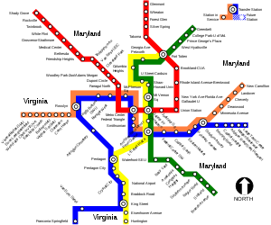
List of stations
The following stations are along the line, from south to north.Stations served during all operating hours:
- Huntington
- Eisenhower Avenue
- King Street – Old Town (joins Blue LineBlue Line (Washington Metro)The Blue Line of the Washington Metro in the United States consists of 27 rapid transit stations from Franconia–Springfield to Largo Town Center. It has stations in Fairfax County, Alexandria and Arlington, Virginia, the District of Columbia, and Prince George's County, Maryland...
on same track) - Braddock Road
- Potomac YardPotomac Yard (WMATA station)Potomac Yard is a planned island platformed Washington Metro station in Alexandria, Virginia, United States. Construction of the station is projected to commence in 2014 and it is scheduled to open in 2016. Potomac Yard station will be operated by the Washington Metropolitan Area Transit Authority...
(planned) - Ronald Reagan Washington National Airport
- Crystal City
- Pentagon City
- Pentagon (Blue LineBlue Line (Washington Metro)The Blue Line of the Washington Metro in the United States consists of 27 rapid transit stations from Franconia–Springfield to Largo Town Center. It has stations in Fairfax County, Alexandria and Arlington, Virginia, the District of Columbia, and Prince George's County, Maryland...
diverges)
- Crosses Potomac RiverPotomac RiverThe Potomac River flows into the Chesapeake Bay, located along the mid-Atlantic coast of the United States. The river is approximately long, with a drainage area of about 14,700 square miles...
via Fenwick Bridge- L'Enfant Plaza (transfer station for the BlueBlue Line (Washington Metro)The Blue Line of the Washington Metro in the United States consists of 27 rapid transit stations from Franconia–Springfield to Largo Town Center. It has stations in Fairfax County, Alexandria and Arlington, Virginia, the District of Columbia, and Prince George's County, Maryland...
, OrangeOrange Line (Washington Metro)The Orange Line of the Washington Metro consists of 26 rapid transit stations from Vienna to New Carrollton. It has stations in Fairfax County and Arlington, Virginia, the District of Columbia, and Prince George's County, Maryland. Half of the line's stations are shared with the Blue Line, and over...
, and planned Silver LinesSilver Line (Washington Metro)The Dulles Corridor Metrorail Project, formally dubbed the Silver Line, is an extension of the Washington Metro rapid transit system, currently under construction with the goal of providing rapid transit service to Dulles International Airport and Tysons Corner...
, and joins Green LineGreen Line (Washington Metro)The Green Line is one of five heavy rail subway lines that constitute the Washington Metro rapid transit system in the Washington, D.C., metropolitan area. The Green Line consists of 21 stations, with termini at Branch Avenue and at Greenbelt. The Green Line runs through Prince George's County,...
on same track) - Archives – Navy Memorial – Penn Quarter
- Gallery Place (transfer station for the Red LineRed Line (Washington Metro)The Red Line of the Washington Metro is a rail rapid transit service operating between 27 stations in Montgomery County, Maryland and the District of Columbia, United States. It is a primary line through downtown Washington, and the oldest and busiest line in the system...
) - Mount Vernon Square (transfer station for the Green LineGreen Line (Washington Metro)The Green Line is one of five heavy rail subway lines that constitute the Washington Metro rapid transit system in the Washington, D.C., metropolitan area. The Green Line consists of 21 stations, with termini at Branch Avenue and at Greenbelt. The Green Line runs through Prince George's County,...
during peak hours; Yellow Line trains terminate on a pocket track north of the station during peak hours)
- L'Enfant Plaza (transfer station for the Blue
Additional stations served during off-peak hours:
- Shaw – Howard University
- U Street / African-American Civil War Memorial / Cardozo
- Columbia Heights
- Georgia Avenue – Petworth
- Fort Totten (transfer station for the Red LineRed Line (Washington Metro)The Red Line of the Washington Metro is a rail rapid transit service operating between 27 stations in Montgomery County, Maryland and the District of Columbia, United States. It is a primary line through downtown Washington, and the oldest and busiest line in the system...
and the Green LineGreen Line (Washington Metro)The Green Line is one of five heavy rail subway lines that constitute the Washington Metro rapid transit system in the Washington, D.C., metropolitan area. The Green Line consists of 21 stations, with termini at Branch Avenue and at Greenbelt. The Green Line runs through Prince George's County,...
). Yellow Line trains cross back over to the southbound tracks via the crossover just north of Fort Totten station.
The final two trains which depart from Huntington before afternoon peak service continue north beyond Fort Totten on to Greenbelt and service the remaining Green Line stations. Additional Yellow Line trains may continue passenger service to Greenbelt during off-peak hours and weekends in order to stage them for Green Line service or for storage at the Greenbelt rail yard. Likewise, trains departing from Greenbelt may be signed as Yellow line trains and travel to Huntington.
Future
On November 16, 1995, WMATA and the developer of the Potomac Yards area of Alexandria, Virginia, signed an agreeement to construct a new station that will be financed by the developer. As of February 2011, WMATA was taking public comments in order to prepare a draft environmental impact statement for the station. A second improvement project involves building a pedestrian tunnel to interconnect the Gallery Place station with Metro Center. A July 2005 study proposed connecting the eastern mezzanine of Metro Center with the western mezzanine of Gallery Place that are only one block apart. The proposed connection would reduce the number of passengers that use the Red Line to transfer between the Yellow Line and the Blue and Orange lines at Metro Center. As of 2011, the project remains unfunded.The WMATA staff has also proposed diverting Blue Line trains during peak hours to the Yellow Line in order to reduce congestion in the Rosslyn tunnel. If approved, the proposed change would take effect in July 2012.
See also
External links
- world.nycsubway.org: Yellow Line