

Wrangell Volcanic Belt
Encyclopedia
Volcanic field
A volcanic field is an area of the Earth's crust that is prone to localized volcanic activity. They usually contain 10 to 100 volcanoes, such as cinder cones and are usually in clusters. Lava flows may also occur...
stretching from eastern Alaska
Alaska
Alaska is the largest state in the United States by area. It is situated in the northwest extremity of the North American continent, with Canada to the east, the Arctic Ocean to the north, and the Pacific Ocean to the west and south, with Russia further west across the Bering Strait...
in the United States
United States
The United States of America is a federal constitutional republic comprising fifty states and a federal district...
to the southwestern Yukon Territory in Canada
Canada
Canada is a North American country consisting of ten provinces and three territories. Located in the northern part of the continent, it extends from the Atlantic Ocean in the east to the Pacific Ocean in the west, and northward into the Arctic Ocean...
. The field includes the four highest volcanoes in the United States, Mount Bona
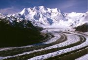
Mount Bona
Mount Bona is one of the major mountains of the Saint Elias Mountains in eastern Alaska, and is the fifth highest independent peak in the United States. Mount Bona and its adjacent neighbor Mount Churchill are both large ice-covered stratovolcanoes...
, Mount Blackburn
Mount Blackburn
Mount Blackburn is the highest peak in the Wrangell Mountains of Alaska in the United States. It is the fifth highest peak in the United States and the twelfth highest peak in North America. The mountain is an old, eroded shield volcano, the second highest volcano in the United States behind Mount...
, Mount Sanford, and Mount Churchill
Mount Churchill
Mount Churchill is a volcano in the Saint Elias Mountains and the Wrangell Volcanic Field of eastern Alaska. Churchill and its higher neighbor Mount Bona about to the southwest are both large ice-covered stratovolcanoes, with Churchill being the fourth highest volcano in the United States and the...
, all of which exceed 15,000 ft (4,600 m) in elevation. It formed as a result of subduction
Subduction
In geology, subduction is the process that takes place at convergent boundaries by which one tectonic plate moves under another tectonic plate, sinking into the Earth's mantle, as the plates converge. These 3D regions of mantle downwellings are known as "Subduction Zones"...
of the Pacific Plate
Pacific Plate
The Pacific Plate is an oceanic tectonic plate that lies beneath the Pacific Ocean. At 103 million square kilometres, it is the largest tectonic plate....
beneath the North American Plate
North American Plate
The North American Plate is a tectonic plate covering most of North America, Greenland, Cuba, Bahamas, and parts of Siberia, Japan and Iceland. It extends eastward to the Mid-Atlantic Ridge and westward to the Chersky Range in eastern Siberia. The plate includes both continental and oceanic crust...
at the easternmost end of the Aleutian Trench
Aleutian Trench
The Aleutian Trench is a subduction zone and oceanic trench which runs along the southern coastline of Alaska and the adjacent waters of northeastern Siberia off the coast of Kamchatka Peninsula. It is classified as a "marginal trench" in the east as it runs along the margin of the continent, and...
.
The bulk of the Wrangell Volcanic Field lies within the Wrangell Mountains
Wrangell Mountains
The Wrangell Mountains are a high mountain range of eastern Alaska in the United States. Much of the range is included in Wrangell-Saint Elias National Park and Preserve. The Wrangell Mountains are almost entirely volcanic in origin, and they include the second and third highest volcanoes in the...
of Alaska, but the field also extends eastwards into the neighboring Saint Elias Mountains
Saint Elias Mountains
The Saint Elias Mountains are a subgroup of the Pacific Coast Ranges, located in southeastern Alaska in the United States, southwestern Yukon and the very far northwestern part of British Columbia in Canada. The range spans Wrangell-St. Elias National Park and Preserve in the USA and Kluane...
and the Yukon Territory.
The east-west length of the field is over 200 mile (320 km), while the width reaches up to 80 miles (130 km) in the central Wrangell Mountains. The field includes numerous shield volcano
Shield volcano
A shield volcano is a type of volcano usually built almost entirely of fluid lava flows. They are named for their large size and low profile, resembling a warrior's shield. This is caused by the highly fluid lava they erupt, which travels farther than lava erupted from more explosive volcanoes...
es, stratovolcano
Stratovolcano
A stratovolcano, also known as a composite volcano, is a tall, conical volcano built up by many layers of hardened lava, tephra, pumice, and volcanic ash. Unlike shield volcanoes, stratovolcanoes are characterized by a steep profile and periodic, explosive eruptions...
es, caldera
Caldera
A caldera is a cauldron-like volcanic feature usually formed by the collapse of land following a volcanic eruption, such as the one at Yellowstone National Park in the US. They are sometimes confused with volcanic craters...
complexes, cinder cones, and extensive lava flows, which have erupted throughout the past 26 million years. All of the higher peaks are less than 5 million years old, since the rate of glacial erosion is very high in this region of extreme snowfall and cold temperatures. Higher elevations of the field above 5,000 ft (1,500 m) are almost entirely covered in glacier
Glacier
A glacier is a large persistent body of ice that forms where the accumulation of snow exceeds its ablation over many years, often centuries. At least 0.1 km² in area and 50 m thick, but often much larger, a glacier slowly deforms and flows due to stresses induced by its weight...
s and icefields, especially on the windward southern side of the ranges.
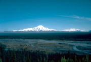
Mount Wrangell
Mount Wrangell is a massive shield volcano located in Wrangell-St. Elias National Park and Preserve in southeastern Alaska, United States. The shield rises over above the Copper River to its southwest. Its volume is over , making it more than twice as massive as Mount Shasta in California, the...
, a massive shield volcano
Shield volcano
A shield volcano is a type of volcano usually built almost entirely of fluid lava flows. They are named for their large size and low profile, resembling a warrior's shield. This is caused by the highly fluid lava they erupt, which travels farther than lava erupted from more explosive volcanoes...
which has been active historically. The stratovolcano
Stratovolcano
A stratovolcano, also known as a composite volcano, is a tall, conical volcano built up by many layers of hardened lava, tephra, pumice, and volcanic ash. Unlike shield volcanoes, stratovolcanoes are characterized by a steep profile and periodic, explosive eruptions...
of Mount Churchill
Mount Churchill
Mount Churchill is a volcano in the Saint Elias Mountains and the Wrangell Volcanic Field of eastern Alaska. Churchill and its higher neighbor Mount Bona about to the southwest are both large ice-covered stratovolcanoes, with Churchill being the fourth highest volcano in the United States and the...
has had the largest recent eruptions, with two large-magnitude explosive eruptions in the last 2,000 years that blanketed most of the Yukon with volcanic ash
Volcanic ash
Volcanic ash consists of small tephra, which are bits of pulverized rock and glass created by volcanic eruptions, less than in diameter. There are three mechanisms of volcanic ash formation: gas release under decompression causing magmatic eruptions; thermal contraction from chilling on contact...
(the White River Ash
White River Ash
The White River Ash is a 2,000 year old ash deposit. It was formed by two large explosive eruptions from the stratovolcano of Mount Churchill that blanketed of Yukon and Northwest Territories, Canada and the U.S. state of Alaska with ash.-See also:...
).
The volcanoes of the western Wrangell Mountains are less than 5 million years old with the youngest lava flows are probably as young as 50,000 years ago. The Canadian portion of the field is dominated by scattered remnants of upper Tertiary
Tertiary
The Tertiary is a deprecated term for a geologic period 65 million to 2.6 million years ago. The Tertiary covered the time span between the superseded Secondary period and the Quaternary...
subaerial lava
Lava
Lava refers both to molten rock expelled by a volcano during an eruption and the resulting rock after solidification and cooling. This molten rock is formed in the interior of some planets, including Earth, and some of their satellites. When first erupted from a volcanic vent, lava is a liquid at...
s and pyroclastic rock
Pyroclastic rock
Pyroclastic rocks or pyroclastics are clastic rocks composed solely or primarily of volcanic materials. Where the volcanic material has been transported and reworked through mechanical action, such as by wind or water, these rocks are termed volcaniclastic...
s. Over large areas extrusive rocks lie in flat undisturbed piles on a Tertiary surface of moderate relief. Locally, however, strata
Stratum
In geology and related fields, a stratum is a layer of sedimentary rock or soil with internally consistent characteristics that distinguish it from other layers...
of the same age have been affected by a late pulse of tectonism, during which they were faulted, contorted into tight symmetrical folds, or overridden by pre-Tertiary baserocks along southwesterly dipping thrust faults. Considerable recent uplift, accompanied by rapid erosion, has reduced once vast areas of upper Tertiary volcanic rocks to small isolated remnants. Although no centers younger than late Miocene
Miocene
The Miocene is a geological epoch of the Neogene Period and extends from about . The Miocene was named by Sir Charles Lyell. Its name comes from the Greek words and and means "less recent" because it has 18% fewer modern sea invertebrates than the Pliocene. The Miocene follows the Oligocene...
are known in Canada, the eruption of rhyolite
Rhyolite
This page is about a volcanic rock. For the ghost town see Rhyolite, Nevada, and for the satellite system, see Rhyolite/Aquacade.Rhyolite is an igneous, volcanic rock, of felsic composition . It may have any texture from glassy to aphanitic to porphyritic...
pumice
Pumice
Pumice is a textural term for a volcanic rock that is a solidified frothy lava typically created when super-heated, highly pressurized rock is violently ejected from a volcano. It can be formed when lava and water are mixed. This unusual formation is due to the simultaneous actions of rapid...
, White River Ash
White River Ash
The White River Ash is a 2,000 year old ash deposit. It was formed by two large explosive eruptions from the stratovolcano of Mount Churchill that blanketed of Yukon and Northwest Territories, Canada and the U.S. state of Alaska with ash.-See also:...
, from Mount Churchill
Mount Churchill
Mount Churchill is a volcano in the Saint Elias Mountains and the Wrangell Volcanic Field of eastern Alaska. Churchill and its higher neighbor Mount Bona about to the southwest are both large ice-covered stratovolcanoes, with Churchill being the fourth highest volcano in the United States and the...
near the head of Klutlan Glacier
Klutlan Glacier
Klutlan Glacier is a long glacier in the U.S. state of Alaska. It is located southwest of Mount Natazhat and flows east across the border with Canada, then north to form the headwaters of the Klutlan River. Its native name was reported in 1891 by C. W. Hayes of the United States Geological Survey....
blanketed large areas of northwestern Canada with tephra
Tephra
200px|thumb|right|Tephra horizons in south-central [[Iceland]]. The thick and light coloured layer at center of the photo is [[rhyolitic]] tephra from [[Hekla]]....
some 2,000 years ago.
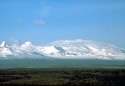
Most of volcanoes of the Western Wrangell Mountains are not like the other volcanoes located around the Pacific Rim
Pacific Rim
The Pacific Rim refers to places around the edge of the Pacific Ocean. The term "Pacific Basin" includes the Pacific Rim and islands in the Pacific Ocean...
. Rather than erupting explosive lavas forming stratovolcanoes, they have been built by the buildup of hundreds of comparatively fluid lava flows to form shield volcanoes. Only the young Mount Wrangell still shows its shield-like form; the other, commonly older volcanoes have had much of their original form removed by glacial and other erosional processes, such as Rabbit Mountain
Rabbit Mountain
Rabbit Mountain is an eroded volcanic outcrop in the Wrangell Volcanic Field, Yukon Territory, Canada, located 30 km southwest of Koidern and 4 km northwest of Canyon Mountain. It is east of the Yukon-Alaska boundary and can be accessed by old mining roads that reach Rabbit Creek...
and Felsite Peak
Felsite Peak
Felsite Peak is an eroded volcanic outcrop in the Wrangell Volcanic Field, Yukon Territory, Canada, located 54 km south of Silver City, 8 km southwest of Snowshoe Peak and 30 km east of Pinnacle Peak....
, which are now eroded to form an outcrop
Outcrop
An outcrop is a visible exposure of bedrock or ancient superficial deposits on the surface of the Earth. -Features:Outcrops do not cover the majority of the Earth's land surface because in most places the bedrock or superficial deposits are covered by a mantle of soil and vegetation and cannot be...
.
Major volcanoes of the Wrangell Volcanic Field include:
- Mount BonaMount BonaMount Bona is one of the major mountains of the Saint Elias Mountains in eastern Alaska, and is the fifth highest independent peak in the United States. Mount Bona and its adjacent neighbor Mount Churchill are both large ice-covered stratovolcanoes...
, 16421 ft (5,005 m), Saint Elias Mountains - Mount BlackburnMount BlackburnMount Blackburn is the highest peak in the Wrangell Mountains of Alaska in the United States. It is the fifth highest peak in the United States and the twelfth highest peak in North America. The mountain is an old, eroded shield volcano, the second highest volcano in the United States behind Mount...
, 16390 ft (4,996 m), Wrangell Mountains - Mount Sanford, 16237 ft (4,949 m), Wrangell Mountains
- Mount ChurchillMount ChurchillMount Churchill is a volcano in the Saint Elias Mountains and the Wrangell Volcanic Field of eastern Alaska. Churchill and its higher neighbor Mount Bona about to the southwest are both large ice-covered stratovolcanoes, with Churchill being the fourth highest volcano in the United States and the...
, 15638 ft (4,766 m), Saint Elias Mountains - Mount WrangellMount WrangellMount Wrangell is a massive shield volcano located in Wrangell-St. Elias National Park and Preserve in southeastern Alaska, United States. The shield rises over above the Copper River to its southwest. Its volume is over , making it more than twice as massive as Mount Shasta in California, the...
, 14163 ft (4,317 m), Wrangell Mountains - Atna PeaksAtna PeaksAtna Peaks is an eroded stratovolcano or shield volcano in the Wrangell Mountains of eastern Alaska. It is located in Wrangell-Saint Elias National Park about 6 mi east of Mount Blackburn, the second highest volcano in the United States, and just south of the massive Nabesna Glacier...
, 13860 ft (4,225 m), Wrangell Mountains - Regal MountainRegal MountainRegal Mountain is an eroded stratovolcano or shield volcano in the Wrangell Mountains of eastern Alaska. It is located in Wrangell-Saint Elias National Park about east of Mount Blackburn, the second highest volcano in the United States, and southeast of the massive Nabesna Glacier...
, 13845 ft (4,220 m), Wrangell Mountains - Mount JarvisMount JarvisMount Jarvis is an eroded shield volcano in the Wrangell Mountains of eastern Alaska. It is located in Wrangell-Saint Elias National Park about east of the summit of Mount Wrangell...
, 13421 ft (4,091 m), Wrangell Mountains - Mount DrumMount DrumMount Drum is a stratovolcano in the Wrangell Mountains of east-central Alaska in the United States. It is located at the extreme western end of the Wrangells, west-southwest of Mount Sanford and the same distance west-northwest of Mount Wrangell...
, 12010 ft (3,661 m), Wrangell Mountains
Volcanoes of the Canadian portion of the Wrangell Volcanic Field include:
- Felsite PeakFelsite PeakFelsite Peak is an eroded volcanic outcrop in the Wrangell Volcanic Field, Yukon Territory, Canada, located 54 km south of Silver City, 8 km southwest of Snowshoe Peak and 30 km east of Pinnacle Peak....
, 8301 ft (2,530 m), Coast Mountains - Rabbit MountainRabbit MountainRabbit Mountain is an eroded volcanic outcrop in the Wrangell Volcanic Field, Yukon Territory, Canada, located 30 km southwest of Koidern and 4 km northwest of Canyon Mountain. It is east of the Yukon-Alaska boundary and can be accessed by old mining roads that reach Rabbit Creek...
, 6857 ft (2,090 m), Nutzotin Mountains
See also
- List of volcanoes in the United States of America
- List of volcanoes in Canada
- Volcanism in CanadaVolcanism in CanadaVolcanism of Canada has produced lava flows, lava plateaus, lava domes, cinder cones, stratovolcanoes, shield volcanoes, submarine volcanoes, calderas, diatremes, and maars, along with examples of more less common volcanic forms such as tuyas and subglacial mounds...
External links
- Alaska Volcano Observatory - Wrangell Volcanic Field
- National Resources Canada: Catalogue of Canadian volcanoes
Alaska°N date=June 2009°W