

Mount Blackburn
Encyclopedia
Mount Blackburn is the highest peak in the Wrangell Mountains
of Alaska
in the United States. It is the fifth highest peak in the United States and the twelfth highest peak in North America. The mountain is an old, eroded shield volcano
, the second highest volcano in the United States behind Mount Bona
and the fifth highest in North America. It was named in 1885 by Lt. Henry T. Allen of the U.S. Army after Joseph Clay Stiles Blackburn
, a U.S. senator from Kentucky
. It is located in the heart of Wrangell – St. Elias National Park, the largest national park in the country.
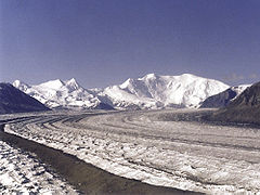
The mountain's massif is covered almost entirely by icefields and glacier
s, and is the principal source of ice for the Kennicott Glacier
, which flows southeast over 20 miles (32 km) to just above the town of McCarthy
. The mountain also contributes a large volume of ice to the north-flowing Nabesna Glacier
and the Kuskulana Glacier
system.
Mount Blackburn is a large, dramatic peak, with great local relief and independence from higher peaks. Its west face drops over 11000 ft (3,352.8 m) to the Kuskulana Glacier in less than 4 horizontal miles (6 km). Its other faces drop 8000–10000 ft (2,438.4–3,048 m), all in less than 8 miles. The toe of the Kuskulana Glacier
, less than 12 miles from the summit, lies at an elevation of 2400 ft (731.5 m), giving a rise of 14000 ft (4,267.2 m). While these figures speak to the peak's relief, one measure of its independence is that it is the 50th most topographically prominent
peak in the world.
The western of Blackburn’s two summits is the mountain’s highpoint, a fact that was not understood until the 1960s when the then new USGS
maps were published. The first ascent of the west peak, and hence Mount Blackburn, was done on May 30, 1958 by Bruce Gilbert, Dick Wahlstrom, Hans Gmoser
, Adolf Bitterlich, and Leon Blumer via the North (also called the Northwest) Ridge. This team made the first ascent of Blackburn, but did not even know it at the time due to the incorrect identification of the highpoint. In fact Blumer’s article in the 1959 American Alpine Journal
is titled “Mount Blackburn – Second Ascent.”
and George Handy via the Kennicott Glacier (on the south side of the mountain) and East Face. This heady exploit was ahead of its time. Dora Keen, driven by a deep desire for the climb, solicited miners from the nearby Kennecott Copper Mines, and forged a route up the heavily crevassed East Face to the East Peak, but did not traverse over to the West Peak. Keen went on to write a famous article for the Saturday Evening Post titled, “First up Mount Blackburn.” In 1912, Keen and Handy thought they were on Blackburn’s highest point.
Today's standard route on the peak is the 1958 ascent route, the North (or Northwest) Ridge, which is approached from the Nabesna Glacier
, on the north side of the mountain, opposite from Keen and Hardy's route. The route starts from an airstrip on the glacier at an altitude of 7200 feet (2,194.6 m). It is a moderate climb by Alaskan standards (Alaska Grade 2).
Wrangell Mountains
The Wrangell Mountains are a high mountain range of eastern Alaska in the United States. Much of the range is included in Wrangell-Saint Elias National Park and Preserve. The Wrangell Mountains are almost entirely volcanic in origin, and they include the second and third highest volcanoes in the...
of Alaska
Alaska
Alaska is the largest state in the United States by area. It is situated in the northwest extremity of the North American continent, with Canada to the east, the Arctic Ocean to the north, and the Pacific Ocean to the west and south, with Russia further west across the Bering Strait...
in the United States. It is the fifth highest peak in the United States and the twelfth highest peak in North America. The mountain is an old, eroded shield volcano
Shield volcano
A shield volcano is a type of volcano usually built almost entirely of fluid lava flows. They are named for their large size and low profile, resembling a warrior's shield. This is caused by the highly fluid lava they erupt, which travels farther than lava erupted from more explosive volcanoes...
, the second highest volcano in the United States behind Mount Bona
Mount Bona
Mount Bona is one of the major mountains of the Saint Elias Mountains in eastern Alaska, and is the fifth highest independent peak in the United States. Mount Bona and its adjacent neighbor Mount Churchill are both large ice-covered stratovolcanoes...
and the fifth highest in North America. It was named in 1885 by Lt. Henry T. Allen of the U.S. Army after Joseph Clay Stiles Blackburn
Joseph Clay Stiles Blackburn
Joseph Clay Stiles Blackburn was a Democratic Representative and Senator from Kentucky. He was the younger brother of Kentucky governor Luke P. Blackburn. Blackburn, a skilled and spirited orator, was also a prominent trial lawyer known for his skill at swaying juries.He was born near Spring...
, a U.S. senator from Kentucky
Kentucky
The Commonwealth of Kentucky is a state located in the East Central United States of America. As classified by the United States Census Bureau, Kentucky is a Southern state, more specifically in the East South Central region. Kentucky is one of four U.S. states constituted as a commonwealth...
. It is located in the heart of Wrangell – St. Elias National Park, the largest national park in the country.
The mountain's massif is covered almost entirely by icefields and glacier
Glacier
A glacier is a large persistent body of ice that forms where the accumulation of snow exceeds its ablation over many years, often centuries. At least 0.1 km² in area and 50 m thick, but often much larger, a glacier slowly deforms and flows due to stresses induced by its weight...
s, and is the principal source of ice for the Kennicott Glacier
Kennicott Glacier
Kennicott Glacier is a glacier in the U.S. state of Alaska. It trends southeast 43 km from Mount Blackburn to its terminus at the head of the Kennicott River in the Wrangell Mountains. It is located in the middle of Wrangell-St...
, which flows southeast over 20 miles (32 km) to just above the town of McCarthy
McCarthy, Alaska
McCarthy is a census-designated place in Valdez-Cordova Census Area, Alaska, United States. The population was 42 at the 2000 census.- Geography and location:...
. The mountain also contributes a large volume of ice to the north-flowing Nabesna Glacier
Nabesna Glacier
Nabesna Glacier is a glacier in the U.S. state of Alaska. Fed by deep snowfall in the Wrangell Mountains, the 75 mile long Nabesna is the longest valley glacier in North America and the world's longest interior valley glacier....
and the Kuskulana Glacier
Kuskulana Glacier
The Kuskulana Glacier is a glacier in the Wrangell Mountains of Alaska.The Kuskulana Glacier trends southwest 24 km from Mount Blackburn to its terminus at the head of Kuskulana River, 46 km northwest of McCarthy in the Wrangell Mountains.Kuskulana is an Indian name given in 1900 by T. G...
system.
Mount Blackburn is a large, dramatic peak, with great local relief and independence from higher peaks. Its west face drops over 11000 ft (3,352.8 m) to the Kuskulana Glacier in less than 4 horizontal miles (6 km). Its other faces drop 8000–10000 ft (2,438.4–3,048 m), all in less than 8 miles. The toe of the Kuskulana Glacier
Kuskulana Glacier
The Kuskulana Glacier is a glacier in the Wrangell Mountains of Alaska.The Kuskulana Glacier trends southwest 24 km from Mount Blackburn to its terminus at the head of Kuskulana River, 46 km northwest of McCarthy in the Wrangell Mountains.Kuskulana is an Indian name given in 1900 by T. G...
, less than 12 miles from the summit, lies at an elevation of 2400 ft (731.5 m), giving a rise of 14000 ft (4,267.2 m). While these figures speak to the peak's relief, one measure of its independence is that it is the 50th most topographically prominent
Topographic prominence
In topography, prominence, also known as autonomous height, relative height, shoulder drop , or prime factor , categorizes the height of the mountain's or hill's summit by the elevation between it and the lowest contour line encircling it and no higher summit...
peak in the world.
The western of Blackburn’s two summits is the mountain’s highpoint, a fact that was not understood until the 1960s when the then new USGS
United States Geological Survey
The United States Geological Survey is a scientific agency of the United States government. The scientists of the USGS study the landscape of the United States, its natural resources, and the natural hazards that threaten it. The organization has four major science disciplines, concerning biology,...
maps were published. The first ascent of the west peak, and hence Mount Blackburn, was done on May 30, 1958 by Bruce Gilbert, Dick Wahlstrom, Hans Gmoser
Hans Gmoser
Johann Wolfgang "Hans" Gmoser, CM is a founder of modern mountaineering in Canada. Born in Austria in 1932, he came to Canada in 1951, and since then has been a major driving force behind the growing popularity of climbing, skiing and guiding.In the 1950s he pioneered new rock climbs, most...
, Adolf Bitterlich, and Leon Blumer via the North (also called the Northwest) Ridge. This team made the first ascent of Blackburn, but did not even know it at the time due to the incorrect identification of the highpoint. In fact Blumer’s article in the 1959 American Alpine Journal
American Alpine Journal
The American Alpine Journal is an annual magazine published by the American Alpine Club. Its mission is "to document and communicate mountain exploration."...
is titled “Mount Blackburn – Second Ascent.”
Other subfeatures
Kennedy Peak, or East Blackburn, 16286 ft (4,964 m), is the eastern summit and the one that was originally thought to be the highest point. The first ascent of this summit was made in 1912 by Dora KeenDora Keen
Dora Keen was an American traveler and Alpinist, also a social and educational worker.-Early life:She was born in Philadelphia, a daughter of the surgeon William Williams Keen...
and George Handy via the Kennicott Glacier (on the south side of the mountain) and East Face. This heady exploit was ahead of its time. Dora Keen, driven by a deep desire for the climb, solicited miners from the nearby Kennecott Copper Mines, and forged a route up the heavily crevassed East Face to the East Peak, but did not traverse over to the West Peak. Keen went on to write a famous article for the Saturday Evening Post titled, “First up Mount Blackburn.” In 1912, Keen and Handy thought they were on Blackburn’s highest point.
Today's standard route on the peak is the 1958 ascent route, the North (or Northwest) Ridge, which is approached from the Nabesna Glacier
Nabesna Glacier
Nabesna Glacier is a glacier in the U.S. state of Alaska. Fed by deep snowfall in the Wrangell Mountains, the 75 mile long Nabesna is the longest valley glacier in North America and the world's longest interior valley glacier....
, on the north side of the mountain, opposite from Keen and Hardy's route. The route starts from an airstrip on the glacier at an altitude of 7200 feet (2,194.6 m). It is a moderate climb by Alaskan standards (Alaska Grade 2).
See also
- 4000 meter peaks of Alaska
- 4000 metre peaks of Canada
- 4000 meter peaks of North America
- 4000 meter peaks of the United States
- Mountain peaks of AlaskaMountain peaks of AlaskaThis article comprises three sortable tables of mountain peaks of the U.S. State of Alaska.Topographic elevation is the vertical distance above the reference geoid, a precise mathematical model of the Earth's sea level as an equipotential gravitational surface. Topographic prominence is the...
- Mountain peaks of CanadaMountain peaks of CanadaThis article comprises three sortable tables of major mountain peaks of Canada.Topographic elevation is the vertical distance above the reference geoid, a precise mathematical model of the Earth's sea level as an equipotential gravitational surface. Topographic prominence is the elevation...
- Mountain peaks of North AmericaMountain peaks of North AmericaThis article comprises three sortable tables of major mountain peaks of greater North America.This article defines greater North America as the portion of the continental landmass of the Americas extending northward from Panama plus the islands surrounding that landmass...
- Mountain peaks of the United StatesMountain peaks of the United StatesThis article comprises three sortable tables of the major mountain peaks of the United States of America.Topographic elevation is the vertical distance above the reference geoid, a precise mathematical model of the Earth's sea level as an equipotential gravitational surface...
- List of volcanoes in the United States of America