
West Rutland, Vermont
Encyclopedia
West Rutland is a town in Rutland County, Vermont
, United States
. The population was 2,326 at the 2010 census. The town center, located in the south central portion of the town and where about 87% of the population resides, is defined by the U.S. Census Bureau as a census-designated place
(CDP). The town is part of the Rutland micropolitan NECTA.
was originally granted in 1761 as one of the New Hampshire Grants
and named after Rutland
, Massachusetts
, the home of the first grantee, John Murrey. It was one of the most successful of those grants because of excellent farmland and gentle topography.
In 1863, there was rioting in West Rutland after the state instituted a draft
.
During a strike in 1868, owners evicted Irish-Catholic workers from company-owned homes, then imported dozens of French-Canadian Catholic "strikebreaker
s" to replace them.
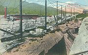
In the early 19th century, small high-quality marble
deposits were discovered in Rutland, and in the 1830s a large deposit of nearly solid marble of high quality was found in what is now West Rutland. By the 1840s small firms had begun operations, but marble quarries
only became profitable when the railroad arrived in 1851. At the same time, the famous quarries of Carrara
in Tuscany
, Italy
, became largely unworkable because of their extreme depth, and Rutland quickly became one of the leading producers of marble in the world.
 This fueled enough growth and investment that in 1886 the marble companies saw to it that when the present Rutland City was incorporated, most of the remainder of the village was split off as West Rutland and Proctor
. Although the closing of the marble quarries in the area in the 1980s and 1990s cost the town many jobs, West Rutland has attracted artists and families looking for a semi-rural lifestyle. Because it is a very rural town, much of its economy is dependent on the city of Rutland.
, the town has a total area of 17.87 square miles (46.3 km²). Drained by the Clarendon River, West Rutland lies between the Taconic Range and the Green Mountains
.
The town is crossed by U.S. Route 4
, Vermont Route 3
, and Vermont Route 4A
.
of 2000, there were 2,535 people, 1,691 households, and 1166 families residing in the town. The population density
was 72.0 people per square mile (54.7/km2). There were 1,079 housing units at an average density of 60.38/sq mi (23.31/km2). The racial makeup of the town was 97.9% White, 0.4% African American
, 0.1% Native American
, 0.7% Asia
n, 0.04% are Pacific Islander, 0.04% from other races, and 0.7% from two or more races. 0.4% of the population were Hispanic
or Latino
of any race.
There were 1,021 households out of which 30.1% had children under the age of 18 living with them, 52.8% were married couples
living together, 10.1% had a female householder with no husband present, and 32.8% were non-families. 25.9% of all households were made up of individuals and 12.7% had someone living alone who was 65 years of age or older. The average household size was 2.48 and the average family size was 3.00.
In the town the population was spread out with 23.8% under the age of 18, 6.6% from 18 to 24, 29.8% from 25 to 44, 24.7% from 45 to 64, and 15.1% who were 65 years of age or older. The median age was 39.0 years. For every 100 females there were 96.1 males. For every 100 females age 18 and over, there were 95.0 males.
The median income for a household in the town was $37,389, and the median income for a family was $41,955. Males had a median income of $30,962 versus $21,935 for females. The per capita income
for the town was $17,325. 14.7% of the population and 11.2% of families were below the poverty line. Out of the total people living in poverty, 60.8% are under the age of 18 and 9.2% are 65 or older.
of 2000, there were 2,263 people, 913 households, and 600 families residing in the CDP. The population density
was 605.5 people per square mile (233.6/km2). There were 966 housing units at an average density of 258.5 per square mile (99.7/km2). The racial makeup of the CDP was 97.83% White, 0.49% Black or African American
, 0.04% Native American, 0.75% Asian, 0.04% Pacific Islander, 0.04% from other races
, and 0.80% from two or more races. Hispanic or Latino of any race were 0.40% of the population.
There were 913 households out of which 29.7% had children under the age of 18 living with them, 51.2% were married couples
living together, 10.4% had a female householder with no husband present, and 34.2% were non-families. 27.2% of all households were made up of individuals and 13.3% had someone living alone who was 65 years of age or older. The average household size was 2.48 and the average family size was 3.03.
In the CDP the population was spread out with 24.0% under the age of 18, 7.1% from 18 to 24, 29.7% from 25 to 44, 24.6% from 45 to 64, and 14.6% who were 65 years of age or older. The median age was 39 years. For every 100 females there were 97.0 males. For every 100 females age 18 and over, there were 95.1 males.
The median income for a household in the CDP was $37,204, and the median income for a family was $41,795. Males had a median income of $30,861 versus $21,936 for females. The per capita income
for the CDP was $17,144. About 6.7% of families and 11.1% of the population were below the poverty line, including 16.3% of those under age 18 and 7.3% of those age 65 or over.
Vermont
Vermont is a state in the New England region of the northeastern United States of America. The state ranks 43rd in land area, , and 45th in total area. Its population according to the 2010 census, 630,337, is the second smallest in the country, larger only than Wyoming. It is the only New England...
, United States
United States
The United States of America is a federal constitutional republic comprising fifty states and a federal district...
. The population was 2,326 at the 2010 census. The town center, located in the south central portion of the town and where about 87% of the population resides, is defined by the U.S. Census Bureau as a census-designated place
Census-designated place
A census-designated place is a concentration of population identified by the United States Census Bureau for statistical purposes. CDPs are delineated for each decennial census as the statistical counterparts of incorporated places such as cities, towns and villages...
(CDP). The town is part of the Rutland micropolitan NECTA.
History
The town of RutlandRutland (town), Vermont
Rutland is a town in Rutland County, Vermont, United States. The population was 4,054 at the 2010 census. Rutland completely surrounds the city of Rutland, which is incorporated separately from the town of Rutland.-History:...
was originally granted in 1761 as one of the New Hampshire Grants
New Hampshire Grants
The New Hampshire Grants or Benning Wentworth Grants were land grants made between 1749 and 1764 by the provincial governor of New Hampshire, Benning Wentworth. The land grants, totaling about 135 , were made on land claimed by New Hampshire west of the Connecticut River, territory that was also...
and named after Rutland
Rutland, Massachusetts
Rutland is a town in Worcester County, Massachusetts, United States. The population was 7,973 at the 2010 census. Worcester County's only buffalo herd is located in Rutland, at Alta Vista Farm...
, Massachusetts
Massachusetts
The Commonwealth of Massachusetts is a state in the New England region of the northeastern United States of America. It is bordered by Rhode Island and Connecticut to the south, New York to the west, and Vermont and New Hampshire to the north; at its east lies the Atlantic Ocean. As of the 2010...
, the home of the first grantee, John Murrey. It was one of the most successful of those grants because of excellent farmland and gentle topography.
In 1863, there was rioting in West Rutland after the state instituted a draft
Conscription
Conscription is the compulsory enlistment of people in some sort of national service, most often military service. Conscription dates back to antiquity and continues in some countries to the present day under various names...
.
During a strike in 1868, owners evicted Irish-Catholic workers from company-owned homes, then imported dozens of French-Canadian Catholic "strikebreaker
Strikebreaker
A strikebreaker is a person who works despite an ongoing strike. Strikebreakers are usually individuals who are not employed by the company prior to the trade union dispute, but rather hired prior to or during the strike to keep the organisation running...
s" to replace them.
In the early 19th century, small high-quality marble
Marble
Marble is a metamorphic rock composed of recrystallized carbonate minerals, most commonly calcite or dolomite.Geologists use the term "marble" to refer to metamorphosed limestone; however stonemasons use the term more broadly to encompass unmetamorphosed limestone.Marble is commonly used for...
deposits were discovered in Rutland, and in the 1830s a large deposit of nearly solid marble of high quality was found in what is now West Rutland. By the 1840s small firms had begun operations, but marble quarries
Quarry
A quarry is a type of open-pit mine from which rock or minerals are extracted. Quarries are generally used for extracting building materials, such as dimension stone, construction aggregate, riprap, sand, and gravel. They are often collocated with concrete and asphalt plants due to the requirement...
only became profitable when the railroad arrived in 1851. At the same time, the famous quarries of Carrara
Carrara
Carrara is a city and comune in the province of Massa-Carrara , notable for the white or blue-grey marble quarried there. It is on the Carrione River, some west-northwest of Florence....
in Tuscany
Tuscany
Tuscany is a region in Italy. It has an area of about 23,000 square kilometres and a population of about 3.75 million inhabitants. The regional capital is Florence ....
, Italy
Italy
Italy , officially the Italian Republic languages]] under the European Charter for Regional or Minority Languages. In each of these, Italy's official name is as follows:;;;;;;;;), is a unitary parliamentary republic in South-Central Europe. To the north it borders France, Switzerland, Austria and...
, became largely unworkable because of their extreme depth, and Rutland quickly became one of the leading producers of marble in the world.
Proctor, Vermont
-Notable people:* Bernard Joseph Flanagan, bishop* F. Ray Keyser, governor of Vermont* Frank Charles Partridge, senator* Fletcher Dutton Proctor, governor of Vermont* Mortimer Robinson Proctor, governor of Vermont...
. Although the closing of the marble quarries in the area in the 1980s and 1990s cost the town many jobs, West Rutland has attracted artists and families looking for a semi-rural lifestyle. Because it is a very rural town, much of its economy is dependent on the city of Rutland.
Geography
West Rutland is located at 43°36′38"N 72°58′23"W, at an elevation of 648 feet (197.5 m), all land. According to the United States Census BureauUnited States Census Bureau
The United States Census Bureau is the government agency that is responsible for the United States Census. It also gathers other national demographic and economic data...
, the town has a total area of 17.87 square miles (46.3 km²). Drained by the Clarendon River, West Rutland lies between the Taconic Range and the Green Mountains
Green Mountains
The Green Mountains are a mountain range in the U.S. state of Vermont. The range extends approximately .-Peaks:The most notable mountains in the range include:*Mount Mansfield, , the highest point in Vermont*Killington Peak, *Mount Ellen,...
.
The town is crossed by U.S. Route 4
U.S. Route 4 in Vermont
In the U.S. state of Vermont, U.S. Route 4 extends for between the New York state line at Fair Haven and the New Hampshire state line at White River Junction. It is one of the main arteries between New York and New Hampshire.-Route description:...
, Vermont Route 3
Vermont Route 3
Vermont Route 3 is a north–south state highway in Rutland County, Vermont, United States. It runs from the town of Rutland to Pittsford.-Route description:...
, and Vermont Route 4A
Vermont Route 4A
Vermont Route 4A is an east–west state highway in Rutland County, Vermont, United States. It runs from Fair Haven to West Rutland. VT 4A was the former alignment of U.S. Route 4 before it was relocated to an expressway.-Route description:...
.
Town center
The boundaries of the town center as defined by the U.S. Census Bureau are as follows: U.S. Route 4 and some power lines on the west; Dewey Avenue on the southwest; Ira town line on the south; the Clarendon River on the southeast; the Rutland town line on the east; the Proctor town line on the northeast and more power lines on the north and northwest. The area of the CDP is 3.7 square miles (9.6 km²), roughly 21% of the total area of the town.Demographics
As of the censusCensus
A census is the procedure of systematically acquiring and recording information about the members of a given population. It is a regularly occurring and official count of a particular population. The term is used mostly in connection with national population and housing censuses; other common...
of 2000, there were 2,535 people, 1,691 households, and 1166 families residing in the town. The population density
Population density
Population density is a measurement of population per unit area or unit volume. It is frequently applied to living organisms, and particularly to humans...
was 72.0 people per square mile (54.7/km2). There were 1,079 housing units at an average density of 60.38/sq mi (23.31/km2). The racial makeup of the town was 97.9% White, 0.4% African American
African American
African Americans are citizens or residents of the United States who have at least partial ancestry from any of the native populations of Sub-Saharan Africa and are the direct descendants of enslaved Africans within the boundaries of the present United States...
, 0.1% Native American
Native Americans in the United States
Native Americans in the United States are the indigenous peoples in North America within the boundaries of the present-day continental United States, parts of Alaska, and the island state of Hawaii. They are composed of numerous, distinct tribes, states, and ethnic groups, many of which survive as...
, 0.7% Asia
Asia
Asia is the world's largest and most populous continent, located primarily in the eastern and northern hemispheres. It covers 8.7% of the Earth's total surface area and with approximately 3.879 billion people, it hosts 60% of the world's current human population...
n, 0.04% are Pacific Islander, 0.04% from other races, and 0.7% from two or more races. 0.4% of the population were Hispanic
Hispanic
Hispanic is a term that originally denoted a relationship to Hispania, which is to say the Iberian Peninsula: Andorra, Gibraltar, Portugal and Spain. During the Modern Era, Hispanic sometimes takes on a more limited meaning, particularly in the United States, where the term means a person of ...
or Latino
Latino
The demonyms Latino and Latina , are defined in English language dictionaries as:* "a person of Latin-American descent."* "A Latin American."* "A person of Hispanic, especially Latin-American, descent, often one living in the United States."...
of any race.
There were 1,021 households out of which 30.1% had children under the age of 18 living with them, 52.8% were married couples
Marriage
Marriage is a social union or legal contract between people that creates kinship. It is an institution in which interpersonal relationships, usually intimate and sexual, are acknowledged in a variety of ways, depending on the culture or subculture in which it is found...
living together, 10.1% had a female householder with no husband present, and 32.8% were non-families. 25.9% of all households were made up of individuals and 12.7% had someone living alone who was 65 years of age or older. The average household size was 2.48 and the average family size was 3.00.
In the town the population was spread out with 23.8% under the age of 18, 6.6% from 18 to 24, 29.8% from 25 to 44, 24.7% from 45 to 64, and 15.1% who were 65 years of age or older. The median age was 39.0 years. For every 100 females there were 96.1 males. For every 100 females age 18 and over, there were 95.0 males.
The median income for a household in the town was $37,389, and the median income for a family was $41,955. Males had a median income of $30,962 versus $21,935 for females. The per capita income
Per capita income
Per capita income or income per person is a measure of mean income within an economic aggregate, such as a country or city. It is calculated by taking a measure of all sources of income in the aggregate and dividing it by the total population...
for the town was $17,325. 14.7% of the population and 11.2% of families were below the poverty line. Out of the total people living in poverty, 60.8% are under the age of 18 and 9.2% are 65 or older.
Town center demographics
As of the censusCensus
A census is the procedure of systematically acquiring and recording information about the members of a given population. It is a regularly occurring and official count of a particular population. The term is used mostly in connection with national population and housing censuses; other common...
of 2000, there were 2,263 people, 913 households, and 600 families residing in the CDP. The population density
Population density
Population density is a measurement of population per unit area or unit volume. It is frequently applied to living organisms, and particularly to humans...
was 605.5 people per square mile (233.6/km2). There were 966 housing units at an average density of 258.5 per square mile (99.7/km2). The racial makeup of the CDP was 97.83% White, 0.49% Black or African American
Race (United States Census)
Race and ethnicity in the United States Census, as defined by the Federal Office of Management and Budget and the United States Census Bureau, are self-identification data items in which residents choose the race or races with which they most closely identify, and indicate whether or not they are...
, 0.04% Native American, 0.75% Asian, 0.04% Pacific Islander, 0.04% from other races
Race (United States Census)
Race and ethnicity in the United States Census, as defined by the Federal Office of Management and Budget and the United States Census Bureau, are self-identification data items in which residents choose the race or races with which they most closely identify, and indicate whether or not they are...
, and 0.80% from two or more races. Hispanic or Latino of any race were 0.40% of the population.
There were 913 households out of which 29.7% had children under the age of 18 living with them, 51.2% were married couples
Marriage
Marriage is a social union or legal contract between people that creates kinship. It is an institution in which interpersonal relationships, usually intimate and sexual, are acknowledged in a variety of ways, depending on the culture or subculture in which it is found...
living together, 10.4% had a female householder with no husband present, and 34.2% were non-families. 27.2% of all households were made up of individuals and 13.3% had someone living alone who was 65 years of age or older. The average household size was 2.48 and the average family size was 3.03.
In the CDP the population was spread out with 24.0% under the age of 18, 7.1% from 18 to 24, 29.7% from 25 to 44, 24.6% from 45 to 64, and 14.6% who were 65 years of age or older. The median age was 39 years. For every 100 females there were 97.0 males. For every 100 females age 18 and over, there were 95.1 males.
The median income for a household in the CDP was $37,204, and the median income for a family was $41,795. Males had a median income of $30,861 versus $21,936 for females. The per capita income
Per capita income
Per capita income or income per person is a measure of mean income within an economic aggregate, such as a country or city. It is calculated by taking a measure of all sources of income in the aggregate and dividing it by the total population...
for the CDP was $17,144. About 6.7% of families and 11.1% of the population were below the poverty line, including 16.3% of those under age 18 and 7.3% of those age 65 or over.
Notable people
- Harvey H. JohnsonHarvey H. JohnsonHarvey Hull Johnson was a U.S. Representative from Ohio.Born in West Rutland, Vermont, Johnson attended the common schools and Middlebury Academy.He studied law....
, congressman - James Patrick LeamyJames Patrick LeamyJames Patrick Leamy was a United States federal judge.Born in West Rutland, Vermont, Leamy received an A.B. from College of the Holy Cross in 1912, an M.A. from Boston College in 1913, and an LL.B. from Harvard Law School in 1915. He was in private practice in Rutland, Vermont from 1916 to 1940....
, judge - George E. RoyceGeorge E. RoyceGeorge Edmund Royce was an American businessman from Rutland, Vermont prominent in the quarrying and building stone industry, owning the True Blue Marble Company and he was a banker jointly founding the Baxter National Bank of Rutland...
, marble company executive and state senator - Aldace F. WalkerAldace F. WalkerAldace Freeman Walker was one of the original members of the Interstate Commerce Commission when the organization was founded in 1887...
, member of Interstate Commerce CommissionInterstate Commerce CommissionThe Interstate Commerce Commission was a regulatory body in the United States created by the Interstate Commerce Act of 1887. The agency's original purpose was to regulate railroads to ensure fair rates, to eliminate rate discrimination, and to regulate other aspects of common carriers, including...
and railway president
Sites of interest
- Carving Studio & Sculpture Center
- Marble Valley Players -- West Rutland Town Hall Theater
- West Rutland Marsh