
Werneth Low
Encyclopedia
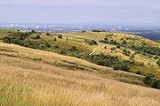
Werneth Low is a hill in Greater Manchester
, England, and a part of the Pennines
. It is located on the borders of Stockport
and Tameside
and rises to height of 279 metres (915 ft). The villages of Gee Cross
, Mottram
and Romiley
lie on the sides of the low.
The term "low" does not refer to any lack of altitude, it being a North English
word for hill.
Werneth Low offers panoramic views over the Greater Manchester Urban Area
and in clear weather, the Winter Hill transmitting station
can be seen from here. To the south, Stockport
town centre, part of
Wythenshawe
in south Manchester and the Welsh Mountains can be viewed in clear weather.
The majority of Werneth Low is administered jointly by Hyde War Memorial Trust (link below) and Tameside Council. The Trust organise the Remembrance and Peace day services. The trust was established to be guardian of Werneth Low and to keep it "For the people of Hyde" and provide a lasting monument to the 710 men of Hyde that perished in World War I.
Manchester landmarks can be seen from the top of Werneth Low; Manchester's Beetham Tower
can be seen and the Oldham
Civic Centre.
stone mace head have been discovered on Werneth Low. Hangingbank is the site of a possible Iron Age
farmstead dating to the first millennium BC, enclosed by a double ditch and featuring crop marks. A Roman road
from Melandra to Astbury probably crosses the hill, however the exact course has not been identified. The site covers 1.23 hectares (3 acre). There is also evidence of Romano-British
activity on Werneth Low, a sherd of Roman pottery dating to the 2nd century AD was discovered in the material filling one of the ditches at Hangingbank, indicating that was when the site fell out of use. There is a possible temporary Roman camp and excavations have recovered a posthole
. The name Werneth derives from the Welsh verno for alder
meaning 'the place where alders grow'.
In 1920 Lower Higham Farm and all its land was purchased by the War Memorial Committee of the Hyde Borough Council in 1920, and in 1921 Hyde
's main war memorial was officially unveiled. A Royal Observer Corps
monitoring post was active here from 1962 to 1968, it was intended to give warning of hostile aircraft and nuclear attacks on the United Kingdom. In the late 1980s, Greater Manchester Council, Tameside Metropolitan Borough Council and the Hyde War Memorial Trust worked together to establish Werneth Low country park
which covers 80 hectares (197.7 acre); the park was officially opened in 1980.
Greater Manchester
Greater Manchester is a metropolitan county in North West England, with a population of 2.6 million. It encompasses one of the largest metropolitan areas in the United Kingdom and comprises ten metropolitan boroughs: Bolton, Bury, Oldham, Rochdale, Stockport, Tameside, Trafford, Wigan, and the...
, England, and a part of the Pennines
Pennines
The Pennines are a low-rising mountain range, separating the North West of England from Yorkshire and the North East.Often described as the "backbone of England", they form a more-or-less continuous range stretching from the Peak District in Derbyshire, around the northern and eastern edges of...
. It is located on the borders of Stockport
Metropolitan Borough of Stockport
The Metropolitan Borough of Stockport is a metropolitan borough of Greater Manchester, in north west England, centred around the town of Stockport. It has a population of about 280,600 and includes the outyling areas of Cheadle and Cheadle Hulme, Marple, Bredbury, Reddish and Romiley...
and Tameside
Tameside
The Metropolitan Borough of Tameside is a metropolitan borough of Greater Manchester in North West England. It is named after the River Tame which flows through the borough and spans the towns of Ashton-under-Lyne, Audenshaw, Denton, Droylsden, Dukinfield, Hyde, Mossley and Stalybridge. Its western...
and rises to height of 279 metres (915 ft). The villages of Gee Cross
Gee Cross
Gee Cross is a suburban village within the Metropolitan Borough of Tameside, in Greater Manchester, England. It lies at the edge of the town of Hyde and borders onto Woodley in the Metropolitan Borough of Stockport...
, Mottram
Mottram in Longdendale
Mottram in Longdendale is an unparished village within the Metropolitan Borough of Tameside, in Greater Manchester, England. It lies in the valley of Longdendale, on the border with Derbyshire and close to the Peak District neighbouring Broadbottom and Hattersley. Mottram in Longdendale Parish was...
and Romiley
Romiley
Romiley is an area of the Metropolitan Borough of Stockport, Greater Manchester, England. It borders Marple, Bredbury and Woodley. In Roman times there is thought to have been a settlement along Sandy Lane...
lie on the sides of the low.
The term "low" does not refer to any lack of altitude, it being a North English
Northern England
Northern England, also known as the North of England, the North or the North Country, is a cultural region of England. It is not an official government region, but rather an informal amalgamation of counties. The southern extent of the region is roughly the River Trent, while the North is bordered...
word for hill.
Werneth Low offers panoramic views over the Greater Manchester Urban Area
Greater Manchester Urban Area
The Greater Manchester Urban Area is an area of land defined by the Office for National Statistics consisting of the large conurbation that encompasses the city of Manchester and the continuous metropolitan area that spreads outwards from it, forming much of Greater Manchester in North West England...
and in clear weather, the Winter Hill transmitting station
Winter Hill transmitting station
The Winter Hill transmitting station is a broadcasting and telecommunications site situated on Winter Hill, at the southern boundary of the Borough of Chorley, and above Bolton in Greater Manchester, England...
can be seen from here. To the south, Stockport
Stockport
Stockport is a town in Greater Manchester, England. It lies on elevated ground southeast of Manchester city centre, at the point where the rivers Goyt and Tame join and create the River Mersey. Stockport is the largest settlement in the metropolitan borough of the same name...
town centre, part of
Wythenshawe
Wythenshawe
Wythenshawe is a district in the south of the city of Manchester, England.Formerly part of the administrative county of Cheshire, in 1931 Wythenshawe was transferred to the City of Manchester, which had begun building a massive housing estate there in the 1920s to resolve the problem of its inner...
in south Manchester and the Welsh Mountains can be viewed in clear weather.
The majority of Werneth Low is administered jointly by Hyde War Memorial Trust (link below) and Tameside Council. The Trust organise the Remembrance and Peace day services. The trust was established to be guardian of Werneth Low and to keep it "For the people of Hyde" and provide a lasting monument to the 710 men of Hyde that perished in World War I.
Manchester landmarks can be seen from the top of Werneth Low; Manchester's Beetham Tower
Beetham Tower, Manchester
Beetham Tower is a landmark 47-storey residential skyscraper in Manchester city centre, England. Completed in 2006, it is named after the developers, Beetham Organization, was designed by Ian Simpson, and built by Carillion....
can be seen and the Oldham
Oldham
Oldham is a large town in Greater Manchester, England. It lies amid the Pennines on elevated ground between the rivers Irk and Medlock, south-southeast of Rochdale, and northeast of the city of Manchester...
Civic Centre.
History
A flint knife and a Bronze AgeBronze Age
The Bronze Age is a period characterized by the use of copper and its alloy bronze as the chief hard materials in the manufacture of some implements and weapons. Chronologically, it stands between the Stone Age and Iron Age...
stone mace head have been discovered on Werneth Low. Hangingbank is the site of a possible Iron Age
Iron Age
The Iron Age is the archaeological period generally occurring after the Bronze Age, marked by the prevalent use of iron. The early period of the age is characterized by the widespread use of iron or steel. The adoption of such material coincided with other changes in society, including differing...
farmstead dating to the first millennium BC, enclosed by a double ditch and featuring crop marks. A Roman road
Roman road
The Roman roads were a vital part of the development of the Roman state, from about 500 BC through the expansion during the Roman Republic and the Roman Empire. Roman roads enabled the Romans to move armies and trade goods and to communicate. The Roman road system spanned more than 400,000 km...
from Melandra to Astbury probably crosses the hill, however the exact course has not been identified. The site covers 1.23 hectares (3 acre). There is also evidence of Romano-British
Roman Britain
Roman Britain was the part of the island of Great Britain controlled by the Roman Empire from AD 43 until ca. AD 410.The Romans referred to the imperial province as Britannia, which eventually comprised all of the island of Great Britain south of the fluid frontier with Caledonia...
activity on Werneth Low, a sherd of Roman pottery dating to the 2nd century AD was discovered in the material filling one of the ditches at Hangingbank, indicating that was when the site fell out of use. There is a possible temporary Roman camp and excavations have recovered a posthole
Posthole
In archaeology a posthole is a cut feature used to hold a surface timber or stone. They are usually much deeper than they are wide although truncation may not make this apparent....
. The name Werneth derives from the Welsh verno for alder
Alder
Alder is the common name of a genus of flowering plants belonging to the birch family . The genus comprises about 30 species of monoecious trees and shrubs, few reaching large size, distributed throughout the North Temperate Zone and in the Americas along the Andes southwards to...
meaning 'the place where alders grow'.
In 1920 Lower Higham Farm and all its land was purchased by the War Memorial Committee of the Hyde Borough Council in 1920, and in 1921 Hyde
Hyde, Greater Manchester
Hyde is a town in the Metropolitan Borough of Tameside, Greater Manchester, England. As of the 2001 census, the town had a population of 31,253. Historically part of Cheshire, it is northeast of Stockport, west of Glossop and east of Manchester....
's main war memorial was officially unveiled. A Royal Observer Corps
Royal Observer Corps
The Royal Observer Corps was a civil defence organisation operating in the United Kingdom between 29 October 1925 and 31 December 1995, when the Corps' civilian volunteers were stood down....
monitoring post was active here from 1962 to 1968, it was intended to give warning of hostile aircraft and nuclear attacks on the United Kingdom. In the late 1980s, Greater Manchester Council, Tameside Metropolitan Borough Council and the Hyde War Memorial Trust worked together to establish Werneth Low country park
Country park
A country park is an area designated for people to visit and enjoy recreation in a countryside environment.-History:In the United Kingdom the term 'Country Park' has a special meaning. There are over 400 Country Parks in England alone . Most Country Parks were designated in the 1970s, under the...
which covers 80 hectares (197.7 acre); the park was officially opened in 1980.