
Watermen's Stairs
Encyclopedia
Transport network
A transport network, or transportation network in American English, is typically a network of roads, streets, pipes, aqueducts, power lines, or nearly any structure which permits either vehicular movement or flow of some commodity....
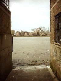
of public stairs, causeways and alleys
Lower Marsh Market
Lower Marsh Market is a street market on Lower Marsh, in the Waterloo neighbourhood adjacent to Waterloo railway station in the London Borough of Lambeth.-References:...
in use from the 14th century onwards to access the waters of the tidal River Thames
River Thames
The River Thames flows through southern England. It is the longest river entirely in England and the second longest in the United Kingdom. While it is best known because its lower reaches flow through central London, the river flows alongside several other towns and cities, including Oxford,...
in Great Britain
Great Britain
Great Britain or Britain is an island situated to the northwest of Continental Europe. It is the ninth largest island in the world, and the largest European island, as well as the largest of the British Isles...
. They were used by watermen
Watermen
Watermen are river workers who transfer passengers across and along city centre rivers and estuaries in Britain and its colonies. Most notable are those on the River Thames and River Medway, but other rivers such as the River Tyne and River Dee, Wales also had their watermen who formed guilds in...
, who taxied passengers across and along the river in London
London
London is the capital city of :England and the :United Kingdom, the largest metropolitan area in the United Kingdom, and the largest urban zone in the European Union by most measures. Located on the River Thames, London has been a major settlement for two millennia, its history going back to its...
.
Stairs were used at high tide
High Tide
High Tide was a band formed in 1969 by Tony Hill , Simon House , Peter Pavli and Roger Hadden .-History:...
, and causeways were used at low tide, built down to the littoral
Littoral
The littoral zone is that part of a sea, lake or river that is close to the shore. In coastal environments the littoral zone extends from the high water mark, which is rarely inundated, to shoreline areas that are permanently submerged. It always includes this intertidal zone and is often used to...
water level from street level, their location was memorized during a waterman's apprenticeship
Apprenticeship
Apprenticeship is a system of training a new generation of practitioners of a skill. Apprentices or protégés build their careers from apprenticeships...
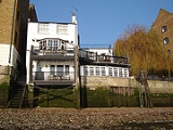
. Stairs were recognized by custom and practice, as safe plying places to pick up and put down passengers and were a valuable aid to rescue should anyone be unfortunate enough to fall into the river, as they were often built adjacent to a public house
Public house
A public house, informally known as a pub, is a drinking establishment fundamental to the culture of Britain, Ireland, Australia and New Zealand. There are approximately 53,500 public houses in the United Kingdom. This number has been declining every year, so that nearly half of the smaller...
.
History
In the 16th century Henry VIII of EnglandHenry VIII of England
Henry VIII was King of England from 21 April 1509 until his death. He was Lord, and later King, of Ireland, as well as continuing the nominal claim by the English monarchs to the Kingdom of France...
, after watching Royal Waterman in a risky maneuver shoot the rapids created by the 20 small arches of the Old London Bridge
London Bridge
London Bridge is a bridge over the River Thames, connecting the City of London and Southwark, in central London. Situated between Cannon Street Railway Bridge and Tower Bridge, it forms the western end of the Pool of London...
, decided to clean up the navigation of the Thames. Wooden structures and water-wheels built out in to the river over centuries were removed and the central part of London 's Thames retreated behind a semi permanent series of walls that lined the sloping foreshore to the river, along these shallow walls, stairs were built down to the water. Two to six storey houses and shops were built along the shoreline.
Alleyways leading down to the Thames became the only practical way to cross over the river via boat as The Old London bridge was frequently blocked. Wharves and latter rudimentary docks
Dock (maritime)
A dock is a human-made structure or group of structures involved in the handling of boats or ships, usually on or close to a shore.However, the exact meaning varies among different variants of the English language...
began to be used to offload goods but most ships simply moored in lines in the middle of the river and their cargo was rowed to shore and carried up shoreline stairs. Some of the Thames original shoreline did remained free from the construction of houses or walls the access to the river was via, shore
Shore
A shore or shoreline is the fringe of land at the edge of a large body of water, such as an ocean, sea, or lake. In Physical Oceanography a shore is the wider fringe that is geologically modified by the action of the body of water past and present, while the beach is at the edge of the shore,...
, gaps between houses used to launch boats. Samuel Pepys
Samuel Pepys
Samuel Pepys FRS, MP, JP, was an English naval administrator and Member of Parliament who is now most famous for the diary he kept for a decade while still a relatively young man...
in his diaries of 1665 mentions making landfall at Dukes shore for example before wading up the beach to Narrow Street
Narrow Street
Narrow Street is a narrow street running parallel to the River Thames through the Limehouse area of east London.- History :A combination of tides and currents made this point on the Thames a natural landfall for ships, the first wharf being completed in 1348...
. As late as the 1850s nearly all new bridges were built with stairs at both ends, and generally on both sides.
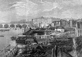
The Embankment
Thames Embankment
The Thames Embankment is a major feat of 19th century civil engineering designed to reclaim marshy land next to the River Thames in central London. It consists of the Victoria and Chelsea Embankment....
which artificially engineered the Thames natural course in the 1860s left buildings that had been located on the gently sloping incline to the river some distance from the water's edge.
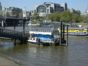
The growth of steamboats in the 1850s allowed boats to dock at specially constructed steamboat piers. Grab chains were built into the now steeply embanked high walls of the central Pool
Pool of London
The Pool of London is a part of the Tideway of the River Thames from London Bridge to below Tower Bridge. It was the original part of the Port of London. The Pool of London is divided into two parts, the Upper Pool and Lower Pool...
of the river Thames as an aide to rescue but access to the busiest central areas was geared towards mass transit by the 1890s. Latter with the increased use of the Hackney carriage
Hackney carriage
A hackney or hackney carriage is a carriage or automobile for hire...
, London's stairs gradually fell into disuse or were simply built over and the abrupt collapse of traffic in the up river docks
Dock (maritime)
A dock is a human-made structure or group of structures involved in the handling of boats or ships, usually on or close to a shore.However, the exact meaning varies among different variants of the English language...
on the central tidal Thames in the 1960s effectively ended their use as transit points within London's transport network.
Cause célèbre
During the 1990s the continued existence of these sites as rights of wayhttp://cms.thames-rrc.org/rowing-on-the-thames/access-to-the-river-thames had seemed untenable, despite their importance to London's transport history http://www.tower-bridge.org.uk/fact1.htm and as future sites for archaeological investigation http://www.english-heritage.org.uk/server/show/conWebDoc.3932. In the 1980s a local lobby group http://politics.guardian.co.uk/politicsobituaries/story/0,1441,1214789,00.html initially based around the Isle of dogsIsle of Dogs
The Isle of Dogs is a former island in the East End of London that is bounded on three sides by one of the largest meanders in the River Thames.-Etymology:...
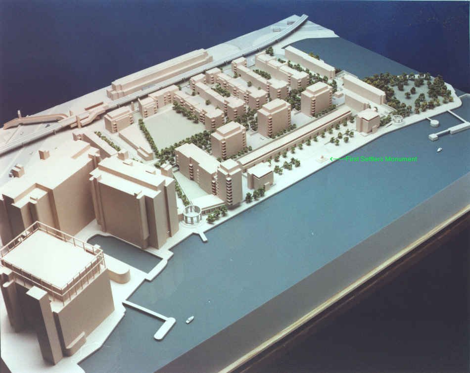
began to campaign for more local involvement, in the urban renewal of London's East End. Many local people who "worked the river"http://www.tower-bridge.org.uk/intro.htm#Introduction began to raise awareness of the decaying state of and lack of river access to the Thames as many stairs and small Docks were bulldozed http://www.tower-bridge.org.uk/monplan3.jpg during massive redevelopment. It became something of a Cause célèbre
Cause célèbre
A is an issue or incident arousing widespread controversy, outside campaigning and heated public debate. The term is particularly used in connection with celebrated legal cases. It is a French phrase in common English use...
amongst local people
Mudlark
A Mudlark is someone who scavenges in river mud for items of value, especially in London during the late 18th and 19th centuries.Mudlarks would search in the muddy shores of the River Thames during low tide, scavenging for anything that could be resold and sometimes, when occasion offered,...
and amateur rowers across London who now felt that the regeneration of London's port districts specifically favoured businesses and property development over the preservation and fair use of river access for local communities and the public.
Meanwhile the newly formed - the Pool of London Partnership - established in 1996 to help promote urban renewal of the areas north and south of the river http://www.pooloflondon.co.uk/news.builder/00546.html began to successfully lobby for the location of Greater London Authority (GLA) building to be in the Pool of London development area.
In 2002, The City of London recommended that river and foreshore access, the stairs and steps on the Thames, should be opened up where there is a "historical precedent and a practical need ".http://cms.cityoflondon.gov.uk/NR/rdonlyres/B793C4BC-BC84-4292-BD17-8B4039003E29/0/DP_PL_riversideappraisal.pdf
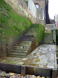
Barely eleven Stairs are still in existence tucked away on the quieter stretches of the river, semi derelict they have not been in regular use since the 1930s. Many of the pubs to which they provided access from water level were destroyed by bombing during World War II
World War II
World War II, or the Second World War , was a global conflict lasting from 1939 to 1945, involving most of the world's nations—including all of the great powers—eventually forming two opposing military alliances: the Allies and the Axis...
http://www.portcities.org.uk/london/server/show/conMediaFile.5680/The-Dog-and-Duck-stairs.html. For centuries these locations dotted along the entire length of the river Thames shoreline were the final points of embarkation at which countless individuals began a forced or chosen new life overseas. It remains to be seen if these strange emotive architectural curiosities, milestones in London's long maritime history, that are located outside the now restored old Pool of London's borders, will be preserved for future generations.
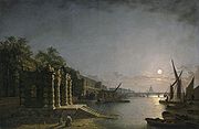
Public stairs in use on the River Thames early 1700s
In 1746 the surveyor and cartographer John RocqueJohn Rocque
John Rocque was a surveyor and cartographer.Rocque was born no later than 1709, since that was the year he moved to England with his parents, who were French Huguenot émigrés...
published a map of London http://freepages.genealogy.rootsweb.com/~genmaps/genfiles/COU_files/ENG/LON/Rocque/rocque_index.htm that listed the main stairs and docks then in use on the Thames.
On the London side of the river, going up stream:
|
Essex House (London) Essex House was a house in London, built around 1575 for Robert Dudley, Earl of Leicester and originally called Leicester House.The property occupied the site where the Outer Temple, part of the London headquarters of the Knights Templar, had previously stood , and was immediately adjacent to the... , Arundel House Arundel House was a town-house or palace located between the Strand and the Thames, near St Clement Danes.It was originally the town house of the Bishops of Bath and Wells, during the Middle Ages. In 1539 it was given to William Fitzwilliam, Earl of Southampton... , Strand, London Strand is a street in the City of Westminster, London, England. The street is just over three-quarters of a mile long. It currently starts at Trafalgar Square and runs east to join Fleet Street at Temple Bar, which marks the boundary of the City of London at this point, though its historical length... , Somerset House Somerset House is a large building situated on the south side of the Strand in central London, England, overlooking the River Thames, just east of Waterloo Bridge. The central block of the Neoclassical building, the outstanding project of the architect Sir William Chambers, dates from 1776–96. It... , Savoy Palace The Savoy Palace was considered the grandest nobleman's residence of medieval London, until it was destroyed in the Peasants' Revolt of 1381. It fronted the Strand, on the site of the present Savoy Theatre and the Savoy Hotel that memorialise its name... , |
York House, Strand York House in the Strand in London was one of a string of mansions which once stood along the route from the City of London to the royal court at Westminster. It was built as the London home of the Bishops of Norwich not later than 1237, and around 300 years later it was acquired by King Henry VIII... , Whitehall Whitehall is a road in Westminster, in London, England. It is the main artery running north from Parliament Square, towards Charing Cross at the southern end of Trafalgar Square... , |
Westminster Bridge Westminster Bridge is a road and foot traffic bridge over the River Thames between Westminster on the north side and Lambeth on the south side, in London, England.... , |
|
Wapping Wapping is a place in the London Borough of Tower Hamlets which forms part of the Docklands to the east of the City of London. It is situated between the north bank of the River Thames and the ancient thoroughfare simply called The Highway... Old, Wapping Wapping is a place in the London Borough of Tower Hamlets which forms part of the Docklands to the east of the City of London. It is situated between the north bank of the River Thames and the ancient thoroughfare simply called The Highway... New, |
Execution Dock Execution Dock was used for more than 400 years in London to execute pirates, smugglers and mutineers that had been sentenced to death by Admiralty courts. The "dock", which consisted of a scaffold for hanging, was located near the shoreline of the River Thames at Wapping... , |
Shadwell Shadwell is an inner-city district situated within the London Borough of Tower Hamlets located on the north bank of the Thames between Wapping to the south and Ratcliff to the east... , Ratcliff Ratcliff or Ratcliffe is a former hamlet lying by the north bank of the River Thames between Shadwell and Limehouse. It is now a district in the London Borough of Tower Hamlets, and is located to the south of Stepney.-Etymology:... Cross, Limehouse Limehouse is a place in the London Borough of Tower Hamlets. It is on the northern bank of the River Thames opposite Rotherhithe and between Ratcliff to the west and Millwall to the east.... , |
Crossing over to the Surrey side above bridge:
|
Lambeth Lambeth is a district of south London, England, and part of the London Borough of Lambeth. It is situated southeast of Charing Cross.-Toponymy:... , |
Lambeth Palace Lambeth Palace is the official London residence of the Archbishop of Canterbury in England. It is located in Lambeth, on the south bank of the River Thames a short distance upstream of the Palace of Westminster on the opposite shore. It was acquired by the archbishopric around 1200... , Vauxhall -Demography:Many Vauxhall residents live in social housing. There are several gentrified areas, and areas of terraced townhouses on streets such as Fentiman Road and Heyford Avenue have higher property values in the private market, however by far the most common type of housing stock within... . |
Going down through the bridge on the Surrey side:
|
|
Rotherhithe Rotherhithe is a residential district in inner southeast London, England and part of the London Borough of Southwark. It is located on a peninsula on the south bank of the Thames, facing Wapping and the Isle of Dogs on the north bank, and is a part of the Docklands area... or Redriff, |
Deptford Deptford is a district of south London, England, located on the south bank of the River Thames. It is named after a ford of the River Ravensbourne, and from the mid 16th century to the late 19th was home to Deptford Dockyard, the first of the Royal Navy Dockyards.Deptford and the docks are... and Greenwich Greenwich Greenwich is a district of south London, England, located in the London Borough of Greenwich.Greenwich is best known for its maritime history and for giving its name to the Greenwich Meridian and Greenwich Mean Time... . |
When J. Wallis and J. Cary published their 1784 map of "London, Westminster and Southwark"
(which showed the Thames from the White Hart Stairs above Lambeth Palace down to Trinity Steps near Stepney),
the stairs appear as follows.
London side: The stair and bridges going downstream from Horse Ferry are:
|
|
|
|
Surrey side: The stairs and bridges* going downstream from White Hart are:
|
|
See also
Thames PathThames Path
The Thames Path is a National Trail, opened in 1996, following the length of the River Thames from its source near Kemble in Gloucestershire to the Thames Barrier at Charlton. It is about long....
Lower Marsh Market
Lower Marsh Market
Lower Marsh Market is a street market on Lower Marsh, in the Waterloo neighbourhood adjacent to Waterloo railway station in the London Borough of Lambeth.-References:...