

Warwick, Massachusetts
Encyclopedia
New England town
The New England town is the basic unit of local government in each of the six New England states. Without a direct counterpart in most other U.S. states, New England towns are conceptually similar to civil townships in other states, but are incorporated, possessing powers like cities in other...
in Franklin County
Franklin County, Massachusetts
-Demographics:As of the census of 2000, there were 71,535 people, 29,466 households, and 18,416 families residing in the county. The population density was 102 people per square mile . There were 31,939 housing units at an average density of 46 per square mile...
, Massachusetts
Massachusetts
The Commonwealth of Massachusetts is a state in the New England region of the northeastern United States of America. It is bordered by Rhode Island and Connecticut to the south, New York to the west, and Vermont and New Hampshire to the north; at its east lies the Atlantic Ocean. As of the 2010...
, United States
United States
The United States of America is a federal constitutional republic comprising fifty states and a federal district...
. The population was 750 at the 2000 census. It is part of the Springfield, Massachusetts
Springfield, Massachusetts
Springfield is the most populous city in Western New England, and the seat of Hampden County, Massachusetts, United States. Springfield sits on the eastern bank of the Connecticut River near its confluence with three rivers; the western Westfield River, the eastern Chicopee River, and the eastern...
Metropolitan Statistical Area
Springfield, Massachusetts metropolitan area
The Springfield Metropolitan Area is a region that is socio-economically and culturally tied to the City of Springfield, Massachusetts. The U.S. Office of Management and Budget defines the Springfield metropolitan statistical area as consisting of three counties in Western Massachusetts. As of...
.
History
Warwick was first settled in 1739 and was officially incorporated in 1763.The land that became Warwick, Massachusetts was one of four tracts of land established by Massachusetts in 1735 to compensate the descendants of the officers and soldiers who served during the "expedition to Canada" and the Battle of Quebec
Battle of Quebec (1690)
The Battle of Quebec was fought in October 1690 between the colonies of New France and Massachusetts Bay, then ruled by the kingdoms of France and England, respectively. It was the first time Quebec's defences were tested....
in 1690. The area was initially called Gardner's Canada and original proprietors were named in 1736. A 1737 owners list names the initial land owners, few of whom appear to have remained to settle the town once it was incorporated in 1763.
It took another 25 years to attract sufficient numbers of settlers to support a town and its minister. In 1760, such numbers were reached and the town hired a young Reverend Lemuel Hedge. The town was formed officially, as Warwick, on 17 Feb 1763. Its first officers were James Ball (town clerk); Moses Evans, Jeduthan Morse, James Ball (selectman and assessors); Amzi Doolittle (treasurer); Samuel Ball (constable); James Ball (collector).
As the Revolutionary War
American Revolutionary War
The American Revolutionary War , the American War of Independence, or simply the Revolutionary War, began as a war between the Kingdom of Great Britain and thirteen British colonies in North America, and ended in a global war between several European great powers.The war was the result of the...
approached, the town voted unanimously in favor of independence, although the town minister preached against it. Rev. Lemuel Hedge was barred from leaving the town in July 1775. He died 15 October 1777, the day British General Burgoyne surrendered his troops to the colonists in Saratoga. In 1776, Lieutenant Thomas Rich was selected to represent the town at the General Assembly of the Massachusetts Bay Colony
Massachusetts Bay Colony
The Massachusetts Bay Colony was an English settlement on the east coast of North America in the 17th century, in New England, situated around the present-day cities of Salem and Boston. The territory administered by the colony included much of present-day central New England, including portions...
.
Shortly before and after the turn of the 19th century, many of Franklin County's old families began to move into Windham County, Vermont
Windham County, Vermont
Windham County is a county located in the U.S. state of Vermont. As of 2010, the population was 44,513. Its shire town is Newfane.-Geography:According to the U.S...
in the generational quest for inexpensive land and frontiers to tame. Among those from Warwick was the Nathan Hastings family who settled in Windham, Vermont
Windham, Vermont
Windham is a town in Windham County, Vermont, United States. The population was 328 at the 2000 census. The town center village is designated as the Windham Village Historic District.-Geography:...
in 1806. They were joined in Windham by others from adjacent villages such as Royalston
Royalston, Massachusetts
Royalston is a town in Worcester County, Massachusetts, United States. The population was 1,258 at the 2010 census.-History:Royalston is a small town in the North Quabbin area of northwestern-central Massachusetts. It was named after Isaac Royal, a landowner. It is very large in land area—about...
and that part of Orange, Massachusetts
Orange, Massachusetts
Orange is a town in Franklin County, Massachusetts, United States. The population was 7,839 at the 2010 census. It is part of the Springfield, Massachusetts Metropolitan Statistical Area.Part of the town is included in the census-designated place of Orange....
now known as the village of North Orange.
A significant event in Warwick's late 20th century history was the arrival of the Brotherhood of the Spirit Commune
Renaissance Community
The Brotherhood of the Spirit was one of the largest and most enduring communes in the northeast United States and as such was a distinct link between the commune phenomenon of the 1960s and the current New Age movement...
which remained in the area through the 1960s and into the 1970s. The commune was led by Michael Metelica Rapunzel. The population of Warwick was only about 450 then, and hundreds of young people came to Warwick to join the commune. There was some friction in the early days, but townspeople and commune members gradually became more cooperative. The commune left Warwick for good in the 1980s.
Geography and Transportation
According to the United States Census BureauUnited States Census Bureau
The United States Census Bureau is the government agency that is responsible for the United States Census. It also gathers other national demographic and economic data...
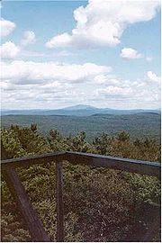
, the town has a total area of 37.6 square miles (97.4 km²), of which, 37.3 square miles (96.6 km²) of it is land and 0.3 square mile (0.776996433 km²) of it (0.90%) is water. The geography of Warwick is dominated by Mount Grace
Mount Grace
Mount Grace, , is a prominent monadnock located in north central Massachusetts in the town of Warwick, approximately two miles south of the New Hampshire border. The mountain is rugged and largely wooded, but a firetower on the summit provides expansive views of the surrounding rural countryside....
. This mountain is located in the center of town and has a network of hiking and cross-country ski trails. Most of the mountain is owned by the state (as part of Mount Grace State Forest
Mount Grace State Forest
Mount Grace State Forest is a Massachusetts state forest located in Warwick. The forest is managed by the Department of Conservation and Recreation .-Description:...
) and open to the public. The Metacomet-Monadnock Trail
Metacomet-Monadnock Trail
The Metacomet-Monadnock Trail is a hiking trail that traverses the Metacomet Ridge of the Pioneer Valley region of Massachusetts and the central uplands of Massachusetts and southern New Hampshire...
passes over the summit. At 1,617 feet, the summit is the highest point between Mount Greylock
Mount Greylock
Mount Greylock is the highest natural point in Massachusetts at . Its peak is located in the northwest corner of the state in the western part of the town of Adams in Berkshire County. Although geologically part of the Taconic Mountains, Mount Greylock is commonly associated with the abutting...
and Mount Wachusett
Mount Wachusett
Mount Wachusett is located in the towns of Princeton and Westminster in Worcester County, Massachusetts. It is the highest point in Massachusetts east of the Connecticut River. The mountain is named after a Native American term meaning "near the mountain" or "mountain place". The mountain is a...
. The Mount Grace Land Conservation Trust
Mount Grace Land Conservation Trust
Mount Grace Land Conservation Trust, incorporated in 1986, is a non-profit organization whose mission is the conservation of woodland and agricultural land in north central and western Massachusetts. Based out of Athol, Massachusetts, the MGLCT is named after Mount Grace, a neaby monadnock...
, which was founded by Warwick resident Keith Ross in 1986, pays homage to the mountain by dint of its name, though its land protection activities take place in 23 municipalities. Approximately a third of the town's land is protected as part of the Warwick State Forest. There are several ponds and brooks through town, including Sheomet Lake, Laurel Lake, Wheeler Reservoir, Richards Reservoir and Hastings Pond. A small wildlife management area is also located within town.
Warwick lies along the borders of Worcester County
Worcester County, Massachusetts
-Demographics:In 1990 Worcester County had a population of 709,705.As of the census of 2000, there were 750,963 people, 283,927 households, and 192,502 families residing in the county. The population density was 496 people per square mile . There were 298,159 housing units at an average density...
and Cheshire County, New Hampshire
Cheshire County, New Hampshire
-Demographics:As of the census of 2000, there were 73,825 people, 28,299 households, and 18,790 families residing in the county. The population density was 104 people per square mile . There were 31,876 housing units at an average density of 45 per square mile...
, in the northeast corner of Franklin County. The town center lies nearly ten miles northwest of Athol
Athol, Massachusetts
Athol is a town in Worcester County, Massachusetts, United States. The population was 11,584 at the 2010 census.-History:Originally called Pequoiag, the area was first settled by five families in September 1735. When the township was incorporated in 1762, the name was changed to Athol...
, twenty miles northeast of the county seat of Greenfield
Greenfield, Massachusetts
Greenfield is a city in Franklin County, Massachusetts, United States. The population was 17,456 at the 2010 census. It is the county seat of Franklin County. Greenfield is home to Greenfield Community College, the Pioneer Valley Symphony Orchestra, and the Franklin County Fair...
, 45 miles northwest of Worcester
Worcester, Massachusetts
Worcester is a city and the county seat of Worcester County, Massachusetts, United States. Named after Worcester, England, as of the 2010 Census the city's population is 181,045, making it the second largest city in New England after Boston....
, 49 miles north-northeast of Springfield
Springfield, Massachusetts
Springfield is the most populous city in Western New England, and the seat of Hampden County, Massachusetts, United States. Springfield sits on the eastern bank of the Connecticut River near its confluence with three rivers; the western Westfield River, the eastern Chicopee River, and the eastern...
and 77 miles west-northwest of Boston
Boston
Boston is the capital of and largest city in Massachusetts, and is one of the oldest cities in the United States. The largest city in New England, Boston is regarded as the unofficial "Capital of New England" for its economic and cultural impact on the entire New England region. The city proper had...
. Warwick is bordered by Winchester, New Hampshire
Winchester, New Hampshire
Winchester is a town in Cheshire County, New Hampshire, United States. The population was 4,341 at the 2010 census. The primary settlement in the town, where 1,733 people resided at the 2010 census, is defined by the U.S. Census Bureau as the Winchester census-designated place...
and Richmond
Richmond, New Hampshire
Richmond is a town in Cheshire County, New Hampshire, United States. The population was 1,155 at the 2010 census.-History:The town was first chartered in 1735 by Governor Jonathan Belcher of Massachusetts...
, New Hampshire to the north, Royalston
Royalston, Massachusetts
Royalston is a town in Worcester County, Massachusetts, United States. The population was 1,258 at the 2010 census.-History:Royalston is a small town in the North Quabbin area of northwestern-central Massachusetts. It was named after Isaac Royal, a landowner. It is very large in land area—about...
(in Worcester County) to the east, Orange
Orange, Massachusetts
Orange is a town in Franklin County, Massachusetts, United States. The population was 7,839 at the 2010 census. It is part of the Springfield, Massachusetts Metropolitan Statistical Area.Part of the town is included in the census-designated place of Orange....
to the south and southeast, Erving
Erving, Massachusetts
Erving is a town in Franklin County, Massachusetts, United States. The population was 1,467 at the 2000 census. It is part of the Springfield, Massachusetts metropolitan statistical area.-History:...
to the southwest, and Northfield
Northfield, Massachusetts
Northfield is a town in Franklin County, Massachusetts, United States. The population was 2,951 at the 2000 census. It is part of the Springfield, Massachusetts Metropolitan Statistical Area...
to the west.
Warwick is a fairly isolated town, located thirteen miles east of the nearest exit along Interstate 91
Interstate 91
Interstate 91 is an Interstate Highway in the New England region of the United States. It provides the primary north–south thoroughfare in the western part of New England...
and eight miles north of Route 2, the major east-west route through northern Massachusetts. The only state highway through town is Route 78
Massachusetts Route 78
Route 78 is a short south–north highway in northeastern Franklin County. Massachusetts.Route 78 begins at Route 2A in Orange, just north of the Springfield Terminal railroad tracks and the Millers River. After , the route enters the town of Warwick...
, which passes between Route 2A in Orange and into New Hampshire, heading towards New Hampshire Route 10. There is no rail or bus service within town, the nearest rail service being in Brattleboro, Vermont
Brattleboro, Vermont
Brattleboro, originally Brattleborough, is a town in Windham County, Vermont, United States, located in the southeast corner of the state, along the state line with New Hampshire. The population was 12,046 at the 2010 census...
along the Amtrak
Amtrak
The National Railroad Passenger Corporation, doing business as Amtrak , is a government-owned corporation that was organized on May 1, 1971, to provide intercity passenger train service in the United States. "Amtrak" is a portmanteau of the words "America" and "track". It is headquartered at Union...
Vermonter
Vermonter
Amtrak's Vermonter is a 611-mile passenger train service between St. Albans , New York City and Washington, D.C. One trip runs in each direction per day....
line. The nearest small airport is the Orange Municipal Airport
Orange Municipal Airport
Orange Municipal Airport, in Orange, Massachusetts, is a public airport owned by Town of Orange. It has two runways, averages 137 flights per day, and has approximately 52 aircraft based on its field.Flight training and parachuting services are available....
, with the nearest national air service at Logan Airport in Boston, Manchester-Boston Regional Airport
Manchester-Boston Regional Airport
Manchester-Boston Regional Airport , commonly referred to simply as "Manchester Airport," is a public airport located three miles south of the central business district of Manchester, New Hampshire on the county line of Hillsborough and Rockingham counties...
and Bradley International Airport
Bradley International Airport
Bradley International Airport is a joint civil-military public airport located in Windsor Locks on the border with East Granby and Suffield, in Hartford County, Connecticut, United States. It is owned by the State of Connecticut....
, all of which are approximately 90 minutes away from the town.
Economy
Warwick has home based businesses, and a few wood shops. There are no stores, gas stations, restaurants, or other commercial businesses. There are farms here that produces grass fed organic dairy products, herbal products, flowers, and vegetables. Another business is logging.There is a farmer's market on the common on Saturday mornings.
Demographics
As of the censusCensus
A census is the procedure of systematically acquiring and recording information about the members of a given population. It is a regularly occurring and official count of a particular population. The term is used mostly in connection with national population and housing censuses; other common...
of 2000, there were 750 people, 293 households, and 210 families residing in the town. The population density
Population density
Population density is a measurement of population per unit area or unit volume. It is frequently applied to living organisms, and particularly to humans...
was 20.1 people per square mile (7.8/km²). There were 343 housing units at an average density of 9.2 per square mile (3.6/km²). The racial makeup of the town was 96.93% White, 0.27% Native American, 0.27% Asian, 1.07% from other races
Race (United States Census)
Race and ethnicity in the United States Census, as defined by the Federal Office of Management and Budget and the United States Census Bureau, are self-identification data items in which residents choose the race or races with which they most closely identify, and indicate whether or not they are...
, and 1.47% from two or more races. Hispanic or Latino of any race were 0.93% of the population.
There were 293 households out of which 32.1% had children under the age of 18 living with them, 59.4% were married couples
Marriage
Marriage is a social union or legal contract between people that creates kinship. It is an institution in which interpersonal relationships, usually intimate and sexual, are acknowledged in a variety of ways, depending on the culture or subculture in which it is found...
living together, 8.9% had a female householder with no husband present, and 28.0% were non-families. 20.5% of all households were made up of individuals and 5.8% had someone living alone who was 65 years of age or older. The average household size was 2.56 and the average family size was 2.99.
In the town the population was spread out with 24.7% under the age of 18, 6.8% from 18 to 24, 29.1% from 25 to 44, 28.4% from 45 to 64, and 11.1% who were 65 years of age or older. The median age was 41 years. For every 100 females there were 102.7 males. For every 100 females age 18 and over, there were 99.6 males.
The median income for a household in the town was $42,083, and the median income for a family was $45,795. Males had a median income of $35,125 versus $26,875 for females. The per capita income
Per capita income
Per capita income or income per person is a measure of mean income within an economic aggregate, such as a country or city. It is calculated by taking a measure of all sources of income in the aggregate and dividing it by the total population...
for the town was $19,989. About 5.9% of families and 8.0% of the population were below the poverty line, including 7.6% of those under age 18 and 1.0% of those age 65 or over.