

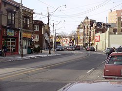
Vaughan Road
Encyclopedia

Toronto
Toronto is the provincial capital of Ontario and the largest city in Canada. It is located in Southern Ontario on the northwestern shore of Lake Ontario. A relatively modern city, Toronto's history dates back to the late-18th century, when its land was first purchased by the British monarchy from...
, Ontario
Ontario
Ontario is a province of Canada, located in east-central Canada. It is Canada's most populous province and second largest in total area. It is home to the nation's most populous city, Toronto, and the nation's capital, Ottawa....
, Canada
Canada
Canada is a North American country consisting of ten provinces and three territories. Located in the northern part of the continent, it extends from the Atlantic Ocean in the east to the Pacific Ocean in the west, and northward into the Arctic Ocean...
. It is a contour collector road
Collector road
A collector road or distributor road is a low to moderate-capacity road which serve to move traffic from local streets to arterial roads. Unlike arterials, collectors are also designed to provide access to residential properties...
that is parallel to a buried
Subterranean river
A subterranean river is a river that runs wholly or partly beneath the ground surface – one where the riverbed does not represent the surface of the Earth ....
creek
Urban stream
An urban stream is a formerly natural waterway that flows through a heavily populated area. Urban streams are often significantly polluted, due to urban runoff and combined sewer outflows....
to the north called Castle Frank Brook
Castle Frank Brook
Castle Frank Brook is a buried creek and south-west flowing tributary of the Don River in central and north-western Toronto, Ontario, originating near the intersection of Lawrence Avenue and Dufferin Street....
. Vaughan Road begins on Bathurst Street
Bathurst Street (Toronto)
Bathurst Street is a main north-south thoroughfare in Toronto. It begins at the Lake Ontario shoreline and continues north to the Toronto boundary of Steeles Avenue...
south of St. Clair Avenue West
St. Clair Avenue
St. Clair Avenue is a major east-west street in Toronto, Ontario, Canada. It was laid out in the late 18th century by the British as a concession road , north of Bloor Street and north of Queen Street....
, then it becomes a north-south street, hence its address numbering system, then it becomes a northwest-southeast street. Finally, Vaughan Road ends in a dead-end
Cul-de-sac
A cul-de-sac is a word of French origin referring to a dead end, close, no through road or court meaning dead-end street with only one inlet/outlet...
near the intersection of Eglinton Avenue
Eglinton Avenue
Eglinton Avenue, originally known as the Richview Sideroad within Etobicoke, is an east-west arterial thoroughfare in Toronto and Mississauga, in the Canadian province of Ontario. Within Toronto, Eglinton Avenue is the only road which crosses through all six former boroughs...
and Dufferin Street
Dufferin Street
Dufferin Street is a major north-south street in Toronto, Ontario, Canada. It is a concession road, two concessions west of Yonge Street. The street starts at the foot of Lake Ontario, continues north to Toronto's northern boundary with some discontinuities and continues into York Region where it...
. Vaughan Road Academy
Vaughan Road Academy
Vaughan Road Academy is a Toronto District School Board International Baccalaureate school in the Oakwood-Vaughan neighbourhood of Toronto, Canada. Vaughan Road is situated at the Vaughan Road and Winona Drive intersection close to Oakwood Avenue and southwest of Forest Hill. It works in...
is named after this road.
History
Vaughan Road was built as early as 1850. Before then, it was a trail used by the First NationsFirst Nations
First Nations is a term that collectively refers to various Aboriginal peoples in Canada who are neither Inuit nor Métis. There are currently over 630 recognised First Nations governments or bands spread across Canada, roughly half of which are in the provinces of Ontario and British Columbia. The...
. Its original alignment began at Yonge Street
Yonge Street
Yonge Street is a major arterial route connecting the shores of Lake Ontario in Toronto to Lake Simcoe, a gateway to the Upper Great Lakes. It was formerly listed in the Guinness Book of Records as the longest street in the world at , and the construction of Yonge Street is designated an "Event of...
, followed Davenport Road to Bathurst Street, then along the current alignment of Vaughan Road into Dufferin Street, in fact, there is still a curve in Dufferin Street at the intersection with Eglinton Avenue, where Vaughan Road connected before the Esso
Esso
Esso is an international trade name for ExxonMobil and its related companies. Pronounced , it is derived from the initials of the pre-1911 Standard Oil, and as such became the focus of much litigation and regulatory restriction in the United States. In 1972, it was largely replaced in the U.S. by...
gas station was built at that intersection. Vaughan Road was then extended north along what is now Dufferin Street into Vaughan Township, which later became the City of Vaughan
Vaughan
Vaughan is a city in York Region north of Toronto, Ontario, Canada. Vaughan is the fastest growing municipality in Canada achieving a population growth rate of 80.2% between 1996–2006, according to Statistics Canada having nearly doubled in population since 1991. Vaughan is located in Southern...
. Therefore, Vaughan Road is named after the township, which itself is named after Benjamin Vaughan
Benjamin Vaughan
Benjamin Vaughan MD LLD was a British commissioner whose role was to smooth negotiations between Britain and the United States during the drafting of the Treaty of Paris....
, a British
Kingdom of Great Britain
The former Kingdom of Great Britain, sometimes described as the 'United Kingdom of Great Britain', That the Two Kingdoms of Scotland and England, shall upon the 1st May next ensuing the date hereof, and forever after, be United into One Kingdom by the Name of GREAT BRITAIN. was a sovereign...
commissioner who signed a peace treaty with the United States
United States
The United States of America is a federal constitutional republic comprising fifty states and a federal district...
in 1783. This road was popular with street racers
Street racing
Street racing is a form of unsanctioned and illegal motor racing which takes place on public roads. Street racing can either be spontaneous or well-planned and coordinated. Well coordinated races are planned in advance and often have people communicating via 2-way radio/citizens' band radio and...
in the 1950s due to its many curves from being parallel to a creek. Since 2000, Vaughan Road had undergone the early stages of gentrification
Gentrification
Gentrification and urban gentrification refer to the changes that result when wealthier people acquire or rent property in low income and working class communities. Urban gentrification is associated with movement. Consequent to gentrification, the average income increases and average family size...
, especially at the corner of Oakwood and Vaughan, as well as the former City of Toronto stretch of Vaughan Road.
Public transit
The road passes through the communities of Humewood–Cedarvale and Oakwood–Vaughan. The Toronto Transit CommissionToronto Transit Commission
-Island Ferry:The ferry service to the Toronto Islands was operated by the TTC from 1927 until 1962, when it was transferred to the Metro Parks and Culture department. Since 1998, the ferry service is run by Toronto Parks and Recreation.-Gray Coach:...
bus route 90 Vaughan serves these communities. The terminus of the 90A branch is the Jesmond loop, which uses the streets Jesmond-Oakwood-Vaughan, thus named for one of the streets. The terminus of the main branch is the Eglinton loop, which is active during rush hour
Rush hour
A rush hour or peak hour is a part of the day during which traffic congestion on roads and crowding on public transport is at its highest. Normally, this happens twice a day—once in the morning and once in the evening, the times during when the most people commute...
only. Both branches of the route feed into St. Clair West station
St. Clair West (TTC)
St. Clair West is a station on the Yonge–University–Spadina line of the subway system in Toronto, Ontario, Canada. It is at 370 St. Clair Avenue West between Bathurst Street and Tweedsmuir Avenue. The sports field of St. Michael's College School is directly above the length of the station; a...
. There is also a stop at Vaughan Road on the 512 St. Clair streetcar route
Toronto streetcar system
The Toronto streetcar system comprises eleven streetcar routes in Toronto, Ontario, Canada, operated by the Toronto Transit Commission , and is the largest such system in the Americas in terms of ridership, number of cars, and track length. The network is concentrated primarily in downtown and in...
.
Landmarks
- Doors painted by Nikki Abraham on the west side of Vaughan Road south of St. Clair Avenue; the artwork is named Broadway Boogie Woogie
- Albert's Real Jamaican Foods
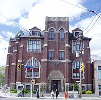
- St. Alphonsus Roman Catholic Church, first constructed as a PresbyterianPresbyterian Church in CanadaThe Presbyterian Church in Canada is the name of a Protestant Christian church, of presbyterian and reformed theology and polity, serving in Canada under this name since 1875, although the United Church of Canada claimed the right to the name from 1925 to 1939...
, then United Church of CanadaUnited Church of CanadaThe United Church of Canada is a Protestant Christian denomination in Canada. It is the largest Protestant church and, after the Roman Catholic Church, the second-largest Christian church in Canada...
congregation named St. Columba, that merged with St. Clair Avenue United Church to become St. Matthew's in 1966. - Dutch Dreams (established in 1985 by Theo Aben, it is among Toronto's best known independent ice cream parlours and competes with Albert's Real Jamaican Foods)
- Vaughan Road AcademyVaughan Road AcademyVaughan Road Academy is a Toronto District School Board International Baccalaureate school in the Oakwood-Vaughan neighbourhood of Toronto, Canada. Vaughan Road is situated at the Vaughan Road and Winona Drive intersection close to Oakwood Avenue and southwest of Forest Hill. It works in...
- Steel palm tree at the bus bay on the south-southeast corner of Oakwood and Vaughan, which cost $350,000 to build and created local controversy