

Urban planning in Singapore
Encyclopedia
Urban planning
Urban planning incorporates areas such as economics, design, ecology, sociology, geography, law, political science, and statistics to guide and ensure the orderly development of settlements and communities....
in Singapore
Singapore
Singapore , officially the Republic of Singapore, is a Southeast Asian city-state off the southern tip of the Malay Peninsula, north of the equator. An island country made up of 63 islands, it is separated from Malaysia by the Straits of Johor to its north and from Indonesia's Riau Islands by the...
has formulated and guided its physical development from the day the modern city-state
City-state
A city-state is an independent or autonomous entity whose territory consists of a city which is not administered as a part of another local government.-Historical city-states:...
was founded in 1819 as a British
British Empire
The British Empire comprised the dominions, colonies, protectorates, mandates and other territories ruled or administered by the United Kingdom. It originated with the overseas colonies and trading posts established by England in the late 16th and early 17th centuries. At its height, it was the...
colony
Colony
In politics and history, a colony is a territory under the immediate political control of a state. For colonies in antiquity, city-states would often found their own colonies. Some colonies were historically countries, while others were territories without definite statehood from their inception....
to the developed, independent country it is today. Urban planning is especially important due to land constraints and its high density.
The Urban Redevelopment Authority
Urban Redevelopment Authority
The Urban Redevelopment Authority is the national urban planning authority of Singapore, and a statutory board under the Ministry of National Development of the Singapore Government.-Mission:The authority was established on 1 April 1974, and is of especially critical importance to the city-state,...
(URA) is Singapore's national land use planning authority. URA prepares long term strategic plans, as well as detailed local area plans, for physical development, and then co-ordinates and guides efforts to bring these plans to reality. Prudent land use planning has enabled Singapore to enjoy strong economic growth and social cohesion, and ensures that sufficient land is safeguarded to support continued economic progress and future development.
Initial planning
The founding of modern Singapore in 1819 by Sir Stamford Raffles was arguably a planning event in itself, as it involved the search for a deep, sheltered harbor suitable to establish a pivotal maritime base for British interests in the Far EastFar East
The Far East is an English term mostly describing East Asia and Southeast Asia, with South Asia sometimes also included for economic and cultural reasons.The term came into use in European geopolitical discourse in the 19th century,...
. The location also needed to keep Britain's maritime trading routes on the East-West axis protected. The settlers found the waters of Keppel Harbour
Keppel Harbour
Keppel Harbour is a stretch of water in Singapore between the mainland and the southern islands of Pulau Brani and Sentosa. Its naturally sheltered and deep waters was to meet the requirements of British colonists attempting to establish a Far East maritime colony in that part of the world, and...
suitable, and an entourage of eight ships anchored off the mouth of a small river on January 28, 1819. Raffles made landing on the north bank of the river and discovered favorable conditions for the setting up of a colony. The area on the side of the river's north bank was level and firm, but the southern bank was swampy. The settlers found abundant fresh water, and the river itself was a sheltered body of water protected by the curved river mouth. The river was to become the nexus from which the new colony would thrive, and the immediate surrounding areas would form the core of the island's business and civic areas.
Upon its formal establishment with the signing of a treaty on February 6 the same year, Raffles left the settlement, leaving Colonel
Colonel
Colonel , abbreviated Col or COL, is a military rank of a senior commissioned officer. It or a corresponding rank exists in most armies and in many air forces; the naval equivalent rank is generally "Captain". It is also used in some police forces and other paramilitary rank structures...
William Farquhar
William Farquhar
Major-General William Farquhar was an employee of the East India Company, and the first Resident of colonial Singapore.-Early life:Farquhar was born at Newhall, Aberdeenshire, near Aberdeen in 1774, and joined the East India Company as a cadet when he was 17...
as the first Resident of Singapore. By the end of May, Raffles returned, and while noting the rapid development of the city, realised the need for a formal urban plan to guide its otherwise disorganised physical expansion. He left the colony again, instructing Farquhar to designate residential, commercial, and governmental land uses for the colony.
When he returned more than two years later in October 1822, however, Raffles was dismayed by the way the colony had grown. He therefore formed a Town Committee headed by Lieutenant
Lieutenant
A lieutenant is a junior commissioned officer in many nations' armed forces. Typically, the rank of lieutenant in naval usage, while still a junior officer rank, is senior to the army rank...
Philip Jackson
Philip Jackson (surveyor)
Philip Jackson was a British Royal Navy lieutenant, who laid out the city plan for Singapore in 1822. He was a key person in Raffles plans for the settlement. The Elgin Bridge in Singapore was once named in his honour.-References:...
to draw up a formal plan for the colony, which came to be known as the Jackson Plan
Jackson Plan
The Jackson Plan of 1822, also known as the "Plan of the Town of Singapore", was an urban plan for Singapore drawn up to maintain some order in the urban development of the fledgling but thriving colony founded just three years earlier...
. The plan was the first detailed city plan for Singapore. It laid the groundwork of the city's street and zonal layout, the essence of which continues today. For example, the allocation of civic institutions on the north bank of the Singapore River and the creation of the main commercial area in what was then known as "Commercial Square" on the south bank have today evolved into the Civic district and the CBD
Central business district
A central business district is the commercial and often geographic heart of a city. In North America this part of a city is commonly referred to as "downtown" or "city center"...
on either side of the river. The grid-like street patterns continue to exist. While the ethnically segregated residential zones are largely depopulated by now, they continue as the ethnic enclaves Chinatown
Chinatown, Singapore
Singapore's Chinatown is an ethnic neighbourhood featuring distinctly Chinese cultural elements and a historically concentrated ethnic Chinese population. Chinatown is located within the larger district of Outram....
, Little India
Little India (location)
Little India is an ethnic enclave containing a large population of Indian people within a society where the majority of people are either not South Asians or where the majority in the enclave are indigenous to states in the country of India within a South Asian Society not identifying as Indian...
, and Kampong Glam
Kampong Glam
Kampong Glam is a neighbourhood in Singapore. It is located north of the Singapore River, in the urban planning areas of Kallang and Rochor.-History:...
, attracting the attention of tourists.
Post-Raffles
Raffles's foresight and well-intended efforts to maintain orderliness in the city's growth started to spiral out of control just eight years after the Jackson Plan was drawn up. With no updates and no new plans drawn up by the British, the city soon outgrew itself, and the plan soon proved completely inadequate. When Raffles arrived in 1819, the population numbered about 150. By 1911, this figure had mushroomed to 185,000, resulting in severe overcrowding, particularly in the ChinatownChinatown, Singapore
Singapore's Chinatown is an ethnic neighbourhood featuring distinctly Chinese cultural elements and a historically concentrated ethnic Chinese population. Chinatown is located within the larger district of Outram....
area. The road system, planned for travel by foot and horse carts, also could not handle the exploding traffic, particularly when motorised vehicles
Automobile
An automobile, autocar, motor car or car is a wheeled motor vehicle used for transporting passengers, which also carries its own engine or motor...
came to Singapore en masse in the 1910s. The 842 private cars in 1915 had multiplied to 3,506 by 1920.
With the severe overcrowding in the city centre, the population, particularly the better-off, started to move into the suburbs. The better-off families moved especially to the East Coast, where they often operated plantation
Plantation
A plantation is a long artificially established forest, farm or estate, where crops are grown for sale, often in distant markets rather than for local on-site consumption...
s and maintained large sea-side homes near the beach at Katong
Katong
Katong is a residential area in the east of Singapore near the seafront. Formerly located by the sea, land was reclaimed all the way to East Coast Park to provide more land for housing and recreational purposes due to shortage of land in the late 1960s after Singapore gained independence.Katong was...
. Several wealthy Malay
Malay people
Malays are an ethnic group of Austronesian people predominantly inhabiting the Malay Peninsula, including the southernmost parts of Thailand, the east coast of Sumatra, the coast of Borneo, and the smaller islands which lie between these locations...
families were to leave a legacy in the area through their family names, including those of Aljunied
Aljunied
Aljunied is a sub-urban area located in the eastern part of the city-state of Singapore. Named after Aljunied Road, it was formally agricultural land which has since been heavily urbanised and presently comprises a variety of landuses...
and Eunos
Eunos, Singapore
Eunos is a neighbourhood in Singapore in the Paya Lebar urban planning area east of the Central Area. Eunos MRT Station serves this area.-Etymology and Early History:...
. Less well-off families tended to move into the southern parts of the island as a natural extension of the Chinatown
Chinatown, Singapore
Singapore's Chinatown is an ethnic neighbourhood featuring distinctly Chinese cultural elements and a historically concentrated ethnic Chinese population. Chinatown is located within the larger district of Outram....
area. Subsequently, however, they also moved into other areas, including the East Coast, spreading the problems of overpopulation to the suburbs with the creation of squatters. This growth also resulted in suburban roads becoming congested by traffic, particularly along Geylang Road
Geylang Road
Geylang Road is a major trunk road linking Singapore's central business district with the eastern suburban areas. Deriving its name from the area of Geylang where the road cuts through, it is fronted on both sides by low-rise shophouses protected statutorily from urban redevelopment in keeping...
which leads to the East Coast.
Public Housing
In 1927, the colonial government attempted to arrest the situation by setting up the Singapore Improvement TrustSingapore Improvement Trust
-History:The Singapore Improvement Trust was a government organisation set up in 1927 by the British colonial government in Singapore in response to the housing needs of the population of Singapore. At that time, many people resided in overcrowded shophouses and squatter settlements, resulting in...
(SIT), with the main aims of alleviating urban congestion and the provision and upgrading of public infrastructure, particularly in the widening of roads to accommodate rising and modernising traffic. Their efforts were evident only in localised areas, as the body did not have the legislative power to produce comprehensive plans or to control urban development. The Second World War
World War II
World War II, or the Second World War , was a global conflict lasting from 1939 to 1945, involving most of the world's nations—including all of the great powers—eventually forming two opposing military alliances: the Allies and the Axis...
also disrupted their efforts during the Japanese occupation
Japanese Occupation of Singapore
The Japanese occupation of Singapore in World War II occurred between about 1942 and 1945 after the fall of Singapore on 15 February 1942. Military forces of the Empire of Japan occupied Singapore after defeating the combined Australian, British, Indian and Malayan garrison in the Battle of Singapore...
from 1941 to 1945.
Singapore emerged from the war in physical ruins and with a large number of homeless residents. A Housing Committee was thus formed quickly in 1947, and reported an acute housing shortage facing the city, where the population had already reached a million by 1950. With 25% of the population living in 1% of its land area, and with some shophouse
Shophouse
A shophouse is a vernacular architectural building type that is commonly seen in areas such as urban Southeast Asia. This hybrid building form characterises the historical centres of most towns and cities in the region.- Design and features :...
s housing over 100 people, the SIT's efforts were clearly inadequate in its attempts to rehouse the population into new multi-story apartment blocks.
Under the People's Action Party
People's Action Party
The People's Action Party is the leading political party in Singapore. It has been the city-state's ruling political party since 1959....
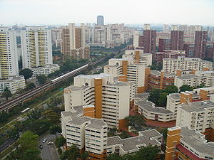
, which came into power when it won the 1959 Elections of Singapore, the Housing Development Board was founded in 1960, replacing the Singapore Improvement Trust. This proved to be the turning point in the history of modern Singapore. Within five years, the HDB had constructed more than 50,000 housing units, which was several times more than the SIT had constructed within the time span of more than 20 years. Within the 1970s, most of the population had found adequate housing. Most of the current urban planning policy is derived from the practices of the HDB.
Flats 10-15 storeys high were initially built. With time, they reached over twenty and thirty storeys, and at present, fifty-story housing complexes are under construction.
Current policy
The current policy of Singapore's urban planners who come under the Urban Redevelopment AuthorityUrban Redevelopment Authority
The Urban Redevelopment Authority is the national urban planning authority of Singapore, and a statutory board under the Ministry of National Development of the Singapore Government.-Mission:The authority was established on 1 April 1974, and is of especially critical importance to the city-state,...
is to create partially self-sufficient
Self-sufficiency
Self-sufficiency refers to the state of not requiring any outside aid, support, or interaction, for survival; it is therefore a type of personal or collective autonomy...
towns and districts which are then further served by four regional centres
Regional centre (Singapore)
A regional centre in the city-state of Singapore is a second-tier commercial zone after the main central business district in the Central Area...
, each of which serves one of the four different regions of Singapore besides the Central Area. These regional centres reduce traffic strain on Singapore's central business district, the Central Area
Central Area
In Singapore, the Central Area or Central Business District contains the core financial and commercial districts, including eleven urban planning areas, namely Downtown Core, Marina East, Marina South, Museum, Newton, Orchard, Outram, River Valley, Rochor, Singapore River and Straits View as...
, by replacing some of the commercial functions the Central Area serves. Each town or district possesses a variety of facilities and amenities allocated strategically to serve as much as possible on at least a basic scale, and on the regional scale, an intermediate one. Any function of the Central Area not served then is allowed by the regional centre to be executed efficiently as the transport routes are planned to link up the regional centres and Central Area effectively. The Housing Development Board works with the Urban Redevelopment Board to develop public housing according to the national urban planning policy.
As land is scarce in what is the most densely populated country, the goal of urban planners is to maximise use of land efficiently yet comfortably and to serve as many people as possible for a particular function, such as housing or commercial purposes in high rise and high density buildings. Infrastructure, environmental conservation, enough space for water catchment
Water resources of Singapore
Water supply and sanitation in Singapore is characterized by a number of achievements in the challenging environment of a densely populated island. Access to water is universal, affordable, efficient and of high quality...
and land for military use are all considerations for national urban planners.
Land reclamation
Land reclamation
Land reclamation, usually known as reclamation, is the process to create new land from sea or riverbeds. The land reclaimed is known as reclamation ground or landfill.- Habitation :...
has continued to be used extensively in urban planning, and Singapore has grown at least 100 square kilometres from its original size before 1819 when it was founded. The urban planning policy demands that most buildings being constructed should be high-rise, with exceptions for conservation efforts for heritage
Cultural heritage
Cultural heritage is the legacy of physical artifacts and intangible attributes of a group or society that are inherited from past generations, maintained in the present and bestowed for the benefit of future generations...
or nature
Nature
Nature, in the broadest sense, is equivalent to the natural world, physical world, or material world. "Nature" refers to the phenomena of the physical world, and also to life in general...
. A pleasant side effect is that many residents have pleasant views. Allocating primary functions in concentrated areas prevents land wastage. This is noticeable in Tampines New Town in comparison to the housing blocks found in Dover
Dover, Singapore
Dover is a relatively small neighbourhood of Singapore, located in Queenstown. It is south of Ghim Moh and north of Kent Ridge. It is often a noted location due to the sheer number of educational facilities it holds, while lying in a zone between Singapore's central business district in the Central...
. Housing blocks turned into complexes, which occupied a large area with thousands of apartments in each one as opposed to smaller high-rise blocks with hundreds. This allows for efficient land use without compromising the standard of living.
Urban planning policy also relies on the effective use of public transport
Public transport
Public transport is a shared passenger transportation service which is available for use by the general public, as distinct from modes such as taxicab, car pooling or hired buses which are not shared by strangers without private arrangement.Public transport modes include buses, trolleybuses, trams...
and other aspects of Singapore's transport system
Transport in Singapore
Transport within Singapore is mainly land-based. Many parts of Singapore are accessible by road, including islands such as Sentosa and Jurong Island. The other major form of transportation within Singapore is rail: the Mass Rapid Transit which runs the length and width of Singapore, and the Light...
. Singapore's Mass Rapid Transit system
Mass Rapid Transit (Singapore)
The Mass Rapid Transit or MRT is a rapid transit system that forms the backbone of the railway system in Singapore, spanning the entire city-state. The initial section of the MRT, between Yio Chu Kang Station and Toa Payoh Station, opened in 1987 establishing itself as the second-oldest metro...
allows the different districts to be linked by rail to all the other districts without having to rely on roads extensively. This also reduces strain on traffic and pollution while saving space. The districts with their different functions are then allocated strategically according to 55 planning areas
Urban planning areas in Singapore
Singapore is currently divided into 55 urban planning areas by the Urban Redevelopment Authority, organised into five regions. A Development Guide Plan is then drawn up for each planning area, providing for detailed planning guidelines for every individual plot of land throughout the country.The...
.
Post-independence Singapore government, with the exception of public housing in Chinatown, has largely shied away from allocating too much housing in the Central Area and especially the Downtown Core
Downtown Core
The Downtown Core is a 266-hectare urban planning area in the south of the city-state of Singapore. The Downtown Core surrounds the mouth of the Singapore River and southeastern portion of its watershed, and is part of the Central Area, Singapore's central business district...
, but with increasing density and land reclamation in Marina South
Marina South
Marina South is a peninsula adjacent to the Central Business District in Singapore, and also the name of an urban planning area in the Central Area of Singapore's Central Region.-History:...
and Marina East
Marina East
Marina East is located at East Coast Park, Singapore. It covers 140 hectares of reclaimed land. The NTUC Club Marina East Course which is a public golf course, is located here.-External links:**...
, there are current plans for new public housing close to the Downtown Core
Downtown Core
The Downtown Core is a 266-hectare urban planning area in the south of the city-state of Singapore. The Downtown Core surrounds the mouth of the Singapore River and southeastern portion of its watershed, and is part of the Central Area, Singapore's central business district...
.
Singapore's land is increasingly crowded, and hence the placement of a district of one function that obstructs more infrastructure development in that area (such as building an expressway tunnel or a rail line), as opposed to the placement of a district of a different function that would accommodate future infrastructure, has become increasingly likely. A district of one function could be inefficient if it does not have proper access to another district of another function, or on the other hand, if it is too close. Public amenities have to be strategically placed in order to benefit the largest number of people possible with minimum redundancy and wastage. A major feature of urban planning in Singapore is to avoid such situations of land wastage.
History
History of Singapore’s urban renewal was related to the Second World War period where it was still a part of British colony. Before the war, Singapore’s housing environment had already been a problem. The tension of both infrastructure and housing conditions were worsen by the rapidly increasing number of Singapore population in 1930s. As a consequence of the war and the lack of economic development, among 1940s to 1950s the previous evil of housing conditions continued to happen. As much as 240,000 squatters were placed in the Singapore’s cities in 1950s. It was caused by the movement of migrants, especially from peninsular MalaysiaPeninsular Malaysia
Peninsular Malaysia , also known as West Malaysia , is the part of Malaysia which lies on the Malay Peninsula. Its area is . It shares a land border with Thailand in the north. To the south is the island of Singapore. Across the Strait of Malacca to the west lies the island of Sumatra...
and the baby boom. In mid 1959, overcrowded slums and squatters were inhabited by a big number of populations, whereas these areas lacked the existence of service facilities such as sanitation.
Plan for Urban Renewal
Since the People Action Party (PAP) government had been in charge, urban renewal included in the part of the national improvement policy that was urgently put in action. Before that, the 1958 master plan had already been designed to solve the city problems. However, due to the lack of urban planningUrban planning
Urban planning incorporates areas such as economics, design, ecology, sociology, geography, law, political science, and statistics to guide and ensure the orderly development of settlements and communities....
experts caused by the deficiency of professional staff, criticism came from many urban practitioners. The professional team recommended by the United Nations
United Nations
The United Nations is an international organization whose stated aims are facilitating cooperation in international law, international security, economic development, social progress, human rights, and achievement of world peace...
then was asked by the PAP government to cope with the urban renewal matters and its redevelopment plan in 1961. Based on the UN assistance report, two pilot developments were initiated in the end of 1964 by the government. These redevelopments then led to the success of Singapore’s urban renewal because the government could provide sufficient amount of public housing and business areas.
Reactions against Urban Renewal
In the establishment of urban renewalUrban renewal
Urban renewal is a program of land redevelopment in areas of moderate to high density urban land use. Renewal has had both successes and failures. Its modern incarnation began in the late 19th century in developed nations and experienced an intense phase in the late 1940s – under the rubric of...
programmes, some difficulties were experienced by the PAP government. The obstacles came from the resistance of people who used to live in the slums and squatters. It was reported by Singapore newspapers that those people were reluctant to be replaced. This became the major problems of 1960s redevelopment schemes. Affordable land value also became one of its reasons. Another problem was that the government had to purchase the private land owned by the middle and upper society to make the land vacant and be used for redevelopment.
The Central Area
Business and residential districts were purposed for the Central AreaCentral Area
In Singapore, the Central Area or Central Business District contains the core financial and commercial districts, including eleven urban planning areas, namely Downtown Core, Marina East, Marina South, Museum, Newton, Orchard, Outram, River Valley, Rochor, Singapore River and Straits View as...
by the UN Main Project (SCP) and Sub Project. The combination of development public accommodation and infrastructure and private development was visualized in the Central Area redevelopment plan. During 1970 to 1995, four major actions were implemented in the Central Area: public housing and service facilities such as stores and marketplaces; the same standards of URA sales programmes with the private developers in constructing the relocation centres and commercial building; the preservation of shop-house area such as Chinatown
Chinatown, Singapore
Singapore's Chinatown is an ethnic neighbourhood featuring distinctly Chinese cultural elements and a historically concentrated ethnic Chinese population. Chinatown is located within the larger district of Outram....
, Little India
Little India, Singapore
Little India is an ethnic neighbourhood found in Singapore that has Tamil cultural elements. Little India lies to east of the Singapore River—across from Chinatown, located west of the river—and north of Kampong Glam. Both areas are part of the urban planning area of Rochor...
and Bussorah Street areas in URA 1988 master plan for conservation; and letting the private sector to own the land, especially in the Central Area
Central Area
In Singapore, the Central Area or Central Business District contains the core financial and commercial districts, including eleven urban planning areas, namely Downtown Core, Marina East, Marina South, Museum, Newton, Orchard, Outram, River Valley, Rochor, Singapore River and Straits View as...
, the Golden Shoe
Golden Shoe (Singapore)
The Golden Shoe district is a zone in the CBD of Singapore. It is 1.6 kilometres from Raffles Place. It is notable for its excellent food and it lies at the heart of the banking district.-External links:*...
, and Orchard Road
Orchard Road
Orchard Road is a road in Singapore that is the retail and entertainment hub of the city-state. It is regularly frequented by the local population as well as being a major tourist attraction...
.
Orchard Road
There were few changes made to Orchard RoadOrchard Road
Orchard Road is a road in Singapore that is the retail and entertainment hub of the city-state. It is regularly frequented by the local population as well as being a major tourist attraction...
where it was a residential area and then slightly altered by the business area development. In 1949, the McDonald House office was built. In 1950s, Orchard Road was turned into a central car distribution centre. In addition, the construction of high-rise apartments began in the early 1960s. Ngee Ann Building, Emerald Hill
Emerald Hill, Singapore
Emerald Hill is a neighbourhood and a conservation area located in the planning areas of Newton and Orchard in Singapore. Former home to many members of the city-state's wealthy Peranakan community, it is located near Orchard Road. Many of its homes feature Chinese Baroque architecture...
, and Cairnhill Mansion were such cases even though these buildings did not succeed in attracting people’s attention. Various other alterations followed, such as the emergence of hotel expansion in mid 1960s, and Orchard Road grew to be the most important shopping districts in Singapore by the mid 1980s. However, in the early 1980s, the government occupied the remaining areas to create an efficient city by recovering a wide range of infrastructures such as road improvement, sewer drainage, telecommunications and so on.
Golden Shoe
The Golden shoe district was planned to be a redevelopment area and was announce on 27 February 1970. It has 34.84 hectares of total area, about 1.6 kilometres from the Raffles PlaceRaffles Place
Raffles Place is a geographical location in Singapore, south of the mouth of the Singapore River. Located in the Downtown Core and the Central Area, it features some of the tallest buildings and landmarks of the country.-History:...
and has a shoe form of pattern.
Precinct NI
This estate has 32 hectares of area covered and placed about 2.4 kilometres from the business district centres of Raffles PlaceRaffles Place
Raffles Place is a geographical location in Singapore, south of the mouth of the Singapore River. Located in the Downtown Core and the Central Area, it features some of the tallest buildings and landmarks of the country.-History:...
/Singapore River
Singapore River
The Singapore River is a river in Singapore with great historical importance. The Singapore River flows from the Central Area, which lies in the Central Region in the southern part of Singapore before emptying into the ocean...
. In 1964, this precinct started to redevelop and finished in 1982, excluding the booked sites in the Beach Road and the MRT Station in Crawford (Lavender MRT Station
Lavender MRT Station
Lavender MRT Station ' is an underground Mass Rapid Transit train station in Singapore. It is located along the East West MRT Line between Bugis Station and Kallang Station...
) for upcoming development. Singapore government demolished the old buildings in the Precincts NI and left only Masjid Hajjah Fatimah
Masjid Hajjah Fatimah
Masjid Hajjah Fatimah is a mosque located along Beach Road in the Kampong Glam district within the Kallang Planning Area in Singapore. The mosque was completed in 1846. The mosque represented a mix of local Islamic and European architecture, having been designed by colonial architect John Turnbull...
(Fatimah Mosque) as a national monument of historical conservation, and construct the new Precincts NI based on the plan. Today, it is known as Kampong Glam
Kampong Glam
Kampong Glam is a neighbourhood in Singapore. It is located north of the Singapore River, in the urban planning areas of Kallang and Rochor.-History:...
.