
.gif)
U7 (Berlin U-Bahn)
Encyclopedia
Line of the Berlin U-Bahn Berlin U-Bahn The Berlin is a rapid transit railway in Berlin, the capital city of Germany, and is a major part of the public transport system of that city. Opened in 1902, the serves 173 stations spread across ten lines, with a total track length of , about 80% of which is underground... |
|
|---|---|
 |
|
| style="margin: auto; border: 0;"> | |
| Length | 31.8 km (19.8 mi) |
| Stations served | 40 |
| Profile | |
| Line completed | 1 October 1984 |
|}
The U7 is a line on the Berlin U-Bahn
Berlin U-Bahn
The Berlin is a rapid transit railway in Berlin, the capital city of Germany, and is a major part of the public transport system of that city. Opened in 1902, the serves 173 stations spread across ten lines, with a total track length of , about 80% of which is underground...
. It runs completely underground for a length of 31.8 kilometres (19.8 mi), through 40 stations; and connects Spandau
Spandau
Spandau is the fifth of the twelve boroughs of Berlin. It is the fourth largest and westernmost borough, situated at the confluence of the Havel and Spree rivers and along the western bank of the Havel, but the least populated.-Overview:...
, via Neukölln
Neukölln
Neukölln is the eighth borough of Berlin, located in the southeastern part of the city and was part of the former American sector under the Four-Power occupation of the city...
, to Gropiusstadt
Gropiusstadt
Gropiusstadt is a locality within the Berlin borough of Neukölln. It was named after the architect who projected the complex: Walter Gropius.-History:...
and Rudow
Rudow
Rudow is a locality within the Berlin borough of Neukölln.-History:The village was founded in 1373. Until 1920 it was a municipality of the former Teltow district, merged into Berlin with the "Greater Berlin Act"...
. The line was originally the south-eastern branch of the Nord-Süd-Bahn (U6
U6 (Berlin U-Bahn)
U6 is a 19.9 km-long line on the Berlin U-Bahn with 29 stations. It belongs to the Großprofilnetz, that is larger profile rail vehicles run through its larger tunnels...
) that ran between the branching point at Belle-Alliance-Straße (Mehringdamm
Mehringdamm (Berlin U-Bahn)
Mehringdamm is a Berlin U-Bahn station located on the and the .Opened in 1924 as Belle-Alliance Strasse it was built by Grenander and later renovated by Rümmler. In 1946 the station was renamed Franz-Mehring-Strasse, after the socialist politician. In 1947, the station received it's current name...
) and Grenzallee
Grenzallee (Berlin U-Bahn)
Grenzallee is a Berlin U-Bahn station located on the U7.Opened in 1930 and built by A.Grenander. It was the end of the north-south line until 1963. The next station is Blaschkoallee.- External links :* * * *...
; however, in the 1960s, this stretch was separated from the rest of the line and extended at each end to form a new line. As of 2007, the U7 is Berlin
Berlin
Berlin is the capital city of Germany and is one of the 16 states of Germany. With a population of 3.45 million people, Berlin is Germany's largest city. It is the second most populous city proper and the seventh most populous urban area in the European Union...
's longest underground line, both in terms of absolute length and total travel time and one of the longest subterranean lines in Europe.
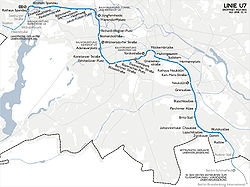
Route
Starting in Rudow, at the junction of Gross-Ziethener Chaussee and Neuköllner Straße, the U7 runs northwest below the road Alt-Rudow, before bearing west under Gropiusstadt. Because the settlement and underground construction there were planned simultaneously, the U7 follows no roads until it reaches Britz-Süd station, where it runs under Fritz-Reuter-Allee as far as Blaschkoallee before joining the route of Buschkrugallee. It continues north, crossing the urban motorway and the Ringbahn while under Karl-Marx-Straße, then heads north-west under Hasenheide, Südstern and Gneisenaustraße until it reaches MehringdammMehringdamm (Berlin U-Bahn)
Mehringdamm is a Berlin U-Bahn station located on the and the .Opened in 1924 as Belle-Alliance Strasse it was built by Grenander and later renovated by Rümmler. In 1946 the station was renamed Franz-Mehring-Strasse, after the socialist politician. In 1947, the station received it's current name...
after a very sharp right curve. A tight left curve brings the U7 under the (Tempelhof waterside) to Möckernbrücke
Möckernbrücke (Berlin U-Bahn)
Möckernbrücke is a station of the Berlin U-Bahn network in the western Kreuzberg district, named after a nearby bridge crossing the Landwehrkanal...
station, with another taking it back and below the area of the former (Anhalter goods station). The route continues west under Yorckstraße, Willmanndamm, Grunewaldstraße, Bayerischer Platz and Berliner Straße, then heads north under Brandenburgische Straße to Adenauerplatz.
A curve into Wilmersdorfer Straße takes the U7 north to Bismarckstraße, where it makes a further turn into Richard-Wagner-Straße, travelling under this road and its northern continuations Wintersteinstraße and Sömmeringstraße. At Jungfernheide station, the U7 crosses the Ringbahn for the second time before passing under the Westhafenkanal
Westhafen Canal
The Westhafen Canal, or Westhafenkanal in German, is a canal in Berlin, Germany. The long canal connects with the Westhafen inland port and the Berlin-Spandau Ship Canal at its eastern end, and with the River Spree in Charlottenburg at its western end...
. The track then turns west through a wide arc and follows Siemensdamm and Nonnendammallee. It passes to the south of the Spandau Citadel
Spandau Citadel
The Spandau Citadel is a fortress in Berlin, Germany, one of the best-preserved Renaissance military structures of Europe. Built from 1559–94 atop a medieval fort on an island created by the meeting of the Havel and the Spree, it was designed to protect the town of Spandau, which is now...
below the road Am Juliusturm, runs under the Old Town of Spandau, and ends at the Spandau city hall.
The U7 passes through 12 districts of Berlin: Rudow, Gropiusstadt, Britz
Britz
Britz is a German locality within the Berlin borough of Neukölln.-History:The village of Britzig was first mentioned in 1273. It was incorporated by the 1920 Greater Berlin Act...
, Neukölln, Kreuzberg
Kreuzberg
Kreuzberg, a part of the combined Friedrichshain-Kreuzberg borough located south of Mitte since 2001, is one of the best-known areas of Berlin...
, Schöneberg
Schöneberg
Schöneberg is a locality of Berlin, Germany. Until Berlin's 2001 administrative reform it was a separate borough including the locality of Friedenau. Together with the former borough of Tempelhof it is now part of the new borough of Tempelhof-Schöneberg....
, Wilmersdorf
Wilmersdorf
Wilmersdorf is an inner city locality of Berlin, formerly a borough by itself but since Berlin's 2001 administrative reform a part of the new borough of Charlottenburg-Wilmersdorf.-History:...
, Charlottenburg
Charlottenburg
Charlottenburg is a locality of Berlin within the borough of Charlottenburg-Wilmersdorf, named after Queen consort Sophia Charlotte...
, Charlottenburg Nord, Siemensstadt
Siemensstadt
The Siemensstadt Housing Estate is a nonprofit residential community in the Charlottenburg-Wilmersdorf district of Berlin. It is one of the six Modernist Housing Estates in Berlin recognized in July 2008 by UNESCO as a World Heritage Site.-Geography:...
, Haselhorst
Haselhorst
Haselhorst is a locality in the borough of Spandau in Berlin. It is located between Siemensstadt and the Old Town of Spandau and is separated from the Hakenfelde locality by the River Havel.-Overview:...
and Spandau.
Construction of the North-South Underground: 1901-1930

Friedrichstraße
The Friedrichstraße is a major culture and shopping street in central Berlin, forming the core of the Friedrichstadt neighborhood. It runs from the northern part of the old Mitte district to the Hallesches Tor in the district of Kreuzberg...
to connect the north to the south. Werner von Siemens also had plans for a north-south line, under Nobelstraße, at the same time, but permission for these was declined on the grounds that public transport should be in municipal ownership. Consequently, Berlin started the construction of the Nord–Süd-Bahn (North–South railway) to link Wedding
Wedding (Berlin)
Wedding is a locality in the borough of Mitte, Berlin, Germany and was a separate borough in the north-western inner city until it was fused with Tiergarten and Mitte in Berlin's 2001 administrative reform...
and Tempelhof
Tempelhof
Tempelhof is a locality of Berlin within the borough of Tempelhof-Schöneberg. It is the location of the former Tempelhof Airport, one of the earliest commercial airports in the world. It is now deserted and shows as a blank spot on maps of Berlin. Attempts are being made to save the still-existing...
(as of 2007, part of the U6
U6 (Berlin U-Bahn)
U6 is a 19.9 km-long line on the Berlin U-Bahn with 29 stations. It belongs to the Großprofilnetz, that is larger profile rail vehicles run through its larger tunnels...
), with a branch to Neukölln.
World War I
World War I
World War I , which was predominantly called the World War or the Great War from its occurrence until 1939, and the First World War or World War I thereafter, was a major war centred in Europe that began on 28 July 1914 and lasted until 11 November 1918...
made the construction work difficult, and finally stopped it completely. In 1919, work started again, but not without further complications. In 1921, during the time of hyperinflation
Hyperinflation
In economics, hyperinflation is inflation that is very high or out of control. While the real values of the specific economic items generally stay the same in terms of relatively stable foreign currencies, in hyperinflationary conditions the general price level within a specific economy increases...
, filling up the existing tunnels was considered as financial turmoil hit hard. The construction work was continued, however, and the first tunnel section from Hallesches Tor
Hallesches Tor (Berlin U-Bahn)
The underground station Hallesches Tor is part of the Berlin U-Bahn network at the intersection of the east-west bound U1 and the north-south bound U6 in the Kreuzberg district.-Overview:...
to Stettiner Bahnhof (later renamed Naturkundemuseum) was opened on 30 January 1923.
The history of the U7 began with the construction of the branch to Neukölln, when the stretch from Hallesches Tor to Gneisenaustraße
Gneisenaustraße (Berlin U-Bahn)
Gneisenaustraße is a station on the U7 U-Bahn in Berlin, Germany. The station was opened in 1924 and created by Alfred Grenander. 1945 it was closed for a few months, 1967/68 the platform was elongated. Due to this the station has lost its appearance as it was when Grenander has planned it.The...
was built; it opened on 9 April 1924. With inflation still taking its toll, the construction work proceeded in small steps only. The extension to Hasenheide station, named after a nearby park (and later renamed Südstern
Südstern (Berlin U-Bahn)
Südstern is a Berlin U-Bahn station located on the .Opened as "Hasenheide" in 1924 , the name changed to "Kaiser-Friedrich-Platz" in 1933 and to "Gardepionierplatz" in 1939....
), followed on 14 December of the same year. As the financial situation of Germany and Berlin improved, so too did the underground railway construction, including the branch to Neukölln.
At Hermannplatz
Hermannplatz (Berlin U-Bahn)
Hermannplatz is a station in the Neukölln district of Berlin which serves as an interchange between the lines and . Operated by the BVG, it is one of the busiest stations on the Berlin U-Bahn system.-History:...
station, which resembles something of an U-Bahn cathedral, the first underground rail–rail crossing in Berlin was developed; transfer to the GN-Bahn (later the U8
U8 (Berlin U-Bahn)
U8 is a line on the Berlin U-Bahn. It has 24 stations and is 18.1 km long. The U8 is one of two north–south Berlin U-Bahn lines, and runs from Wittenau to Neukölln via Gesundbrunnen...
) was intended at this station. The station is also the first Berlin underground station to use escalators. The section from Hasenheide to Bergstraße (later Karl-Marx-Straße
Karl-Marx-Straße (Berlin U-Bahn)
Karl-Marx-Straße is a Berlin U-Bahn station located on the .The station was opened in 1926 as "Bergstrasse" and renamed in 1946, although Karl Marx was a hero of the socialist republic of East Germany the station is in former West-Berlin. 1968 the station was elongated to 105m, due to this a lot...
) was put into operation on 11 April 1926. The final stage of the Neuköllner branch at that time, the 1.5 kilometre-long (0.9 mi) extension to Grenzallee
Grenzallee (Berlin U-Bahn)
Grenzallee is a Berlin U-Bahn station located on the U7.Opened in 1930 and built by A.Grenander. It was the end of the north-south line until 1963. The next station is Blaschkoallee.- External links :* * * *...
, was put into operation on 21 December 1930—the same day of the opening of what would become the U5
U5 (Berlin U-Bahn)
U5 is a line on the Berlin U-Bahn. It runs from Alexanderplatz in Mitte eastwards through Friedrichshain, Lichtenberg and Friedrichsfelde, surfaces in Biesdorf to pass Kaulsdorf and Hellersdorf above ground and finally reaches city limits at Hönow....
line—during one of the largest underground opening celebrations. Underground passengers could then travel from Seestraße, through the city centre, to either Tempelhof
Tempelhof (Berlin U-Bahn)
Tempelhof is a railway station in the district of Berlin with the same name. It is served by the S-Bahn lines , , and and the U-Bahn line . The S-Bahn station is on an embankment at the junction of Tempelhofer Damm and Bundesautobahn 100, about 1 km south of the entrance to the former...
or Grenzallee.
The post-war underground lines were marked out from their 1901–1914 predecessors by their larger tunnels and trains, in order to provide greater competition with the privately-run (Berlin Elevated Railway Company). The new trains and tunnels, which were wider but used the same standard-gauge
Standard gauge
The standard gauge is a widely-used track gauge . Approximately 60% of the world's existing railway lines are built to this gauge...
track, were described as (large profile).
Connection to Rudow
Following World War IIWorld War II
World War II, or the Second World War , was a global conflict lasting from 1939 to 1945, involving most of the world's nations—including all of the great powers—eventually forming two opposing military alliances: the Allies and the Axis...
—in which many of Berlin's residences were destroyed—large new housing developments were needed. Britz and Britz-Buckow-Rudow (BBR; later renamed Gropiusstadt), which were established in the south of West Berlin
West Berlin
West Berlin was a political exclave that existed between 1949 and 1990. It comprised the western regions of Berlin, which were bordered by East Berlin and parts of East Germany. West Berlin consisted of the American, British, and French occupation sectors, which had been established in 1945...
, required a new rapid-transit railway connection to the West Berlin city centre; the construction work for the underground railway began on 2 November 1959.
The track from Grenzallee to Britz-Süd
Britz-Süd (Berlin U-Bahn)
Britz-Süd is a Berlin U-Bahn station located on the .It was opened in 1963 and constructed by W.Düttmann. Characteristics are the grey tiles on the walls. This station only has a southern entrance. The station is only 3,5m below the street. The next station is Johannisthaler Chaussee.- Notes :...
opened on 28 September 1963. Travel to Zwickauer Damm
Zwickauer Damm (Berlin U-Bahn)
Zwickauer Damm is a Berlin U-Bahn station located on the .Finished in 1970 by R.G.Rümmler it was the end of the line U7 . The next station is Rudow.-References:...
was made possible on 2 January 1970, and Rudow
Rudow (Berlin U-Bahn)
Rudow is a Berlin U-Bahn station located on the . There is a bus link to Schönefeld Airport from here.Opened in 1972 by architect Rümmler it is the end station of the U7 line. Storage sidings for subway trains at the southern end measure about 350m. The next is Zwickauer Damm .- References :...
received connection to line 7 on 1 July 1972.
Extension to the west
The branch station Belle-Alliance-Straße (later renamed MehringdammMehringdamm (Berlin U-Bahn)
Mehringdamm is a Berlin U-Bahn station located on the and the .Opened in 1924 as Belle-Alliance Strasse it was built by Grenander and later renovated by Rümmler. In 1946 the station was renamed Franz-Mehring-Strasse, after the socialist politician. In 1947, the station received it's current name...
), which opened in 1924, had three tracks: a connection to Tempelhof led from the first platform; to Neukölln from the second; and to the city centre from the third. A separation of the Neuköllner branch from the North-South Line was decided upon in order to avoid an overload on the transfer station Hallesches Tor
Hallesches Tor (Berlin U-Bahn)
The underground station Hallesches Tor is part of the Berlin U-Bahn network at the intersection of the east-west bound U1 and the north-south bound U6 in the Kreuzberg district.-Overview:...
. Therefore, Line 7 was extended west from Belle-Alliance-Straße. The construction work began in the middle of 1962, and was completed on 26 February 1966 with the link to Möckernbrücke
Möckernbrücke (Berlin U-Bahn)
Möckernbrücke is a station of the Berlin U-Bahn network in the western Kreuzberg district, named after a nearby bridge crossing the Landwehrkanal...
station. Beside the construction of Möckernbrücke station, changes to Mehringdamm station—which would become a transfer point between unbranched lines—were necessary.
The further extension of Line 7 was accomplished with subsidy funds. The construction of the track from Möckernbrücke to Fehrbelliner Platz
Fehrbelliner Platz (Berlin U-Bahn)
Fehrbelliner Platz is a station of the Berlin U-Bahn located in the Wilmersdorf district on the and the .The U3 section was opened on October 12, 1913 as one of the line's original stations, the U7 section on January 29, 1971 with the line's extension from Möckernbrücke...
started on 1 July 1962, and finished on 29 January 1971.
In three stages to Spandau: 1960-1984
At the end of the 1960s, ideas about an underground railway line to Spandau arose again. The planned extension to Line 7 through Mierendorffplatz, Jungfernheide, and Nonnendammallee was chosen to improve public transportation to Siemensstadt—important for its many jobs. The construction work for the section Fehrbelliner Platz–Richard-Wagner-PlatzRichard-Wagner-Platz (Berlin U-Bahn)
Richard-Wagner-Platz is a Berlin U-Bahn station located on the in the Charlottenburg district.The original station opened on May 14, 1906 under the name Wilhelmplatz, together with Deutsche Oper the first of several U-Bahn stations designed by Alfred Grenander...
began in 1969.
Adenauerplatz
Adenauerplatz (Berlin U-Bahn)
Adenauerplatz is a Berlin U-Bahn station on the line. It opened on April 28, 1978 with the line's extension to Richard-Wagner-Platz. The eponymous street is named after politician Konrad Adenauer....
station was designed as a transfer station to accommodate the planned connection to Uhlandstraße
Uhlandstraße (Berlin U-Bahn)
The underground station Uhlandstraße is the western terminus of U1 line, which is part of the Berlin U-Bahn network in Germany.The station opened on October 12, 1913 as the first section of a projected metro line connecting Wittenbergplatz with Berlin-Halensee railway station which was never built...
. Wilmersdorfer Straße
Wilmersdorfer Straße (Berlin U-Bahn)
Wilmersdorfer Straße is a Berlin U-Bahn station located on the .The station is on Wilmersdorfers Straße, which is a big street full of shops like Karstadt, DM, and the Wilmersdorfers Arcaden, a 4-floor shopping mall....
was constructed with a pedestrian passage to the Charlottenburg
Berlin-Charlottenburg railway station
Berlin-Charlottenburg is a railway station situated in the Charlottenburg district of Berlin. The station is used by the , , and lines of the Berlin S-Bahn as well as regional trains operated by Deutsche Bahn.-History:...
S-Bahn
Berlin S-Bahn
The Berlin S-Bahn is a rapid transit system in and around Berlin, the capital city of Germany. It consists of 15 lines and is integrated with the mostly underground U-Bahn to form the backbone of Berlin's rapid transport system...
station. At Bismarckstraße
Bismarckstraße (Berlin U-Bahn)
Bismarckstraße is a Berlin U-Bahn station located in the Charlottenburg district on the and lines.The two-level station opened on 28 April 1978 in the course of the extension of the U7 line from Fehrbelliner Platz to Richard-Wagner-Platz at the interchange with the U2 built in 1908...
, a new underground railway station had to be built, since the pre-existing tunnel of Line 1 (later renamed U2
U2 (Berlin U-Bahn)
U2 is a line on the Berlin U-Bahn. The U2 line starts at the Pankow urban rail station, runs through the eastern city centre to Potsdamer Platz, the western city centre and finally to the Ruhleben terminal station.The U2 has 29 stations and a length of...
) was in a bad condition that necessitated extensive repair works. After Bismarckstraße, 23 houses had to be underpinned
Underpinning
In construction, underpinning is the process of strengthening and stabilizing the foundation of an existing building or other structure. Underpinning may be necessary for a variety of reasons:*The original foundation is simply not strong or stable enough....
, therefore the shield drive
Tunnel boring machine
A tunnel boring machine also known as a "mole", is a machine used to excavate tunnels with a circular cross section through a variety of soil and rock strata. They can bore through anything from hard rock to sand. Tunnel diameters can range from a metre to almost 16 metres to date...
was used for tunnelling this section. The stage from Fehrbelliner Platz to Richard-Wagner-Platz was put into operation on 28 April 1978, with the extension to Rohrdamm
Rohrdamm (Berlin U-Bahn)
thumb|220px|right|Berlin U-Bahn station Rohrdamm. Tubes and cogwheels refer to the surrounding industry.Rohrdamm is a station on the Berlin U-Bahn line U7 in the Siemensstadt district....
following on 1 October 1980, providing the district of Spandau with its first underground connection.
The costs of the extension to the Spandau city centre rose to unexpected heights: it consumed 680 million German mark
German mark
The Deutsche Mark |mark]], abbreviated "DM") was the official currency of West Germany and Germany until the adoption of the euro in 2002. It is commonly called the "Deutschmark" in English but not in German. Germans often say "Mark" or "D-Mark"...
s as a result of the need to undercut the Havel
Havel
The Havel is a river in north-eastern Germany, flowing through the German states of Mecklenburg-Vorpommern, Brandenburg, Berlin and Saxony-Anhalt. It is a right tributary of the Elbe river and in length...
river and the swampy ground in the surrounding area. On 1 October 1984, the last section of the U7 from Rohrdamm to Rathaus Spandau was opened, with the then Federal Chancellor of Germany, Helmut Kohl
Helmut Kohl
Helmut Josef Michael Kohl is a German conservative politician and statesman. He was Chancellor of Germany from 1982 to 1998 and the chairman of the Christian Democratic Union from 1973 to 1998...
, in attendance.
Line colour and name
In 1966, the branched C line had a violet map colour. After it was separated from the rest of the line and line names were changed from letters to numbers, this route was called (Line 7), and was represented by a grey line. After 1978, however, it was changed to a bright blue, because it is more easily discerned on the map. Since 1984, when all the underground lines received a "U" prefix, it has been called "U7".In popular culture
In March 2009, TML-Studios released 'World of Subways Vol. 2: U7 - Berlin' for Windows, which gives players the opportunity to operate a train on the U7 Line in either F90 or H01 rolling stock.Further reading
- Jürgen Meyer-Kronthaler, Klaus Kurpjuweit: Berliner U-Bahn – In Fahrt seit Hundert Jahren. be.bra Verlag, Berlin 2001. ISBN 3-930863-99-5
- Petra Domke, Markus Hoeft: Tunnel, Gräben, Viadukte. 100 Jahre Baugeschichte der Berliner U-Bahn. Kulturbild-Verlag, Berlin 1998. ISBN 3-933300-00-2
- Ulrich Lemke, Uwe Poppel: Berliner U-Bahn. 3. Aufl. Alba Verlag, Düsseldorf 1992. ISBN 3-87094-346-7
- Alfred Gottwald: Das Berliner U- und S-Bahnnetz. Eine Geschichte in Streckenplänen. Argon, Berlin 1994. ISBN 3-87024-284-1