
Tödi
Encyclopedia
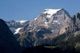
The Tödi or Piz Russein, is the highest mountain
in the Glarus
Alps
and the highest summit in the Canton of Glarus
, Switzerland
. It is located on the border between the cantons of Graubünden
(south) and Glarus (north). Although not the culminating point of Graubünden, it is its highest peak outside the Bernina range
.
 The Tödi lies in the west part of the Glarus Alps, between Linthal
on the north and Disentis on the south. The Tödi is a vast mountain mass projecting as a promontory to the north from the range that divides the basin of the Linth
from that of the Rhine. There are three principal peaks. The lowest, and northernmost, which is that seen from the Ober Sand Alp, is called Sandgipfel (3,390 m). That locally known as Glärner Tödi (3,574 m), long supposed to be the highest, and most conspicuous from Stachelberg and other points of view to the north, is actually the second in height. The highest summit (3,614 m) lies west of the Glärner Tödi, and is distinguished by the Graubünden name Piz Russein.
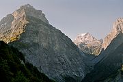
The central mass of the mountain is enclosed between two glaciers, of which the most considerable is the Biferten Glacier
. This originates in a vast snow-basin south-east of the Tödi, bounded to the south by the peaks of Stoc Grond, Piz Urlaun
and Bifertenstock
, forming the boundary of the two cantons. The last-named peak is connected with the Selbsanft
by a massive wall of precipitous rocks enclosing the glacier on the east side, and forcing it, after descending at first nearly due east, to bend round first to north-east, and then due north. On the opposite side a ridge of rocks called Bifertengrätli, descending north-east from the Tödi, forms the boundary of the Biferten Glacier. The end of this nearest the Tödi is the Grünhorn, whereon stood the first hut of the Swiss Alpine Club
. The Biferten Glacier is difficult to access, owing to its steepness. It includes some ice-falls, with intermediate steeps, and is much crevassed. On the west side of the Tödi lies the Sand Glacier or Sandfirn, which descends towards the Sand Alp from the dividing ridge forming the pass to the south. This does not extend so far south as the head of the Biferten Glacier. The ridge running due north from the Stoc Grond to the summit of the Tödi overlooks the head of the Val Russein on the Graubünden side of the chain, but it appears that the main mass of the Tödi lies altogether on the north side of the watershed.
The 1,570-metre
prominence is particularly visible from the Glarus side, where the difference of altitude between the summit and the Linth valley is almost 3 km. The difference is smaller on the south side as the Rhine valley is above 1,000 metres.
, which, according to Escher von der Linth
, overlies a pioritic granite
with large felspar crystals. The summit and the northern flank are mainly composed of metamorphic slate
, in which talc
predominates, but is sometimes replaced by felspar, so that the rock sometimes approaches the condition of gneiss and sometimes that of mica slate. There are manifest traces of anthracite, especially at the Bifertengrätli, where the rock in some places assumes the appearance of a quartzite
mixed with fragment of talc, which has elsewhere in this region been referred to the Verrucano. To these strata succeed dolomite
and Jurassic
limestone
, similar in character to those developed on a large scale in the canton of Glarus.
, one of the founders of mountaineering. He was born in 1752 and entered the monastery of Disentis. It was not until 1824 that the peak was climbed, when Placidus a Spescha, accompanied by a servant and two chamois-hunters, made his sixth and final assault from the south side. On the way up they spent a night at the Russein huts and the next day, on September 1, they climbed to the gap called Porta da Spescha where Placidus and the servant watched the two hunters complete the climb to the top. They were Augustin Bisquolm and Placi Curschellas
On April 19, 1863, the Swiss Alpine Club
is founded. Rudolf Theodor Simler became central president, and designated the Tödi and Clariden
region as the first area of exploration. A simple shelter was made at the foot of the mountain near the Biferten Glacier, the Grünhorn Hut, which was the first mountain hut of the Swiss Alpine Club.
Europe contains some of the world's largest vertical relief available to mountaineers, including lines that exceed the scale of Himalayan routes. According to Reudi Beglinger, mountain guide and founder of Selkirk Mountain Experience, ski-mountaineering options on the Tödi include what is "generally considered one of the most technically difficult lines in the Alps, almost a 10,000-foot descent".
Mountain
Image:Himalaya_annotated.jpg|thumb|right|The Himalayan mountain range with Mount Everestrect 58 14 160 49 Chomo Lonzorect 200 28 335 52 Makalurect 378 24 566 45 Mount Everestrect 188 581 920 656 Tibetan Plateaurect 250 406 340 427 Rong River...
in the Glarus
Glarus Alps
The Glarus Alps are a mountain range in central Switzerland. They extend from the Oberalp Pass to the Klausen Pass, and are bordered by the Urner Alps to the west, the Lepontine Alps to the south and the Appenzell Alps to the northeast...
Alps
Swiss Alps
The Swiss Alps are the portion of the Alps mountain range that lies within Switzerland. Because of their central position within the entire Alpine range, they are also known as the Central Alps....
and the highest summit in the Canton of Glarus
Canton of Glarus
The Canton of Glarus is a canton in east central Switzerland. The capital is Glarus.The population speaks a variety of Alemannic German.The majority of the population identifies as Christian, about evenly split between the Protestant and Catholic confessions.-History:According to legend, the...
, Switzerland
Switzerland
Switzerland name of one of the Swiss cantons. ; ; ; or ), in its full name the Swiss Confederation , is a federal republic consisting of 26 cantons, with Bern as the seat of the federal authorities. The country is situated in Western Europe,Or Central Europe depending on the definition....
. It is located on the border between the cantons of Graubünden
Graubünden
Graubünden or Grisons is the largest and easternmost canton of Switzerland. The canton shares borders with the cantons of Ticino, Uri, Glarus and St. Gallen and international borders with Italy, Austria and Liechtenstein...
(south) and Glarus (north). Although not the culminating point of Graubünden, it is its highest peak outside the Bernina range
Bernina Range
The Bernina Range is a mountain range in the Alps of eastern Switzerland and northern Italy. It is considered to be part of the Central Eastern Alps. It is one of the highest ranges of the Alps, covered with many glaciers. Piz Bernina , its highest peak, is the most easterly four thousand-metre...
.
Geography
Linthal
Linthal is a former municipality in the canton of Glarus in Switzerland. Effective from 1 January 2011, Linthal is part of the municipality of Glarus Süd.-Geography:...
on the north and Disentis on the south. The Tödi is a vast mountain mass projecting as a promontory to the north from the range that divides the basin of the Linth
Linth
The Linth is a Swiss river starting above Linthal the mountains of Glarus near the Klausen Pass and flowing from there north through the Glarus valley passing Schwanden, where it is joined by its main tributary Sernft, Ennenda, the town of Glarus, Netstal, and Näfels, from where it is channeled to...
from that of the Rhine. There are three principal peaks. The lowest, and northernmost, which is that seen from the Ober Sand Alp, is called Sandgipfel (3,390 m). That locally known as Glärner Tödi (3,574 m), long supposed to be the highest, and most conspicuous from Stachelberg and other points of view to the north, is actually the second in height. The highest summit (3,614 m) lies west of the Glärner Tödi, and is distinguished by the Graubünden name Piz Russein.
The central mass of the mountain is enclosed between two glaciers, of which the most considerable is the Biferten Glacier
Biferten Glacier
The Biferten Glacier is a 4 km long glacier situated in the Glarus Alps in the canton of Glarus in Switzerland. In 1973 it had an area of 2.81 km². The glacier is located east of the Tödi.-External links:*...
. This originates in a vast snow-basin south-east of the Tödi, bounded to the south by the peaks of Stoc Grond, Piz Urlaun
Piz Urlaun
Piz Urlaun is a mountain in the Glarus Alps, located on the border between the cantons of Glarus and Graubünden. It lies on the ridge between the Tödi and the Bifertenstock. Both sides are covered by glaciers.-External links:*...
and Bifertenstock
Bifertenstock
The Bifertenstock is a mountain in the Glarus Alps, located between the cantons of Glarus and Graubünden . It overlooks four valleys: the Biferten Glacier valley on the north-west, the Limmern Glacier on the north-east, the Val Punteglias on the south-west and the Val Frisal on the south-east...
, forming the boundary of the two cantons. The last-named peak is connected with the Selbsanft
Selbsanft
The Selbsanft is a mountain in the Glarus Alps, overlooking the valley of Linthal in the canton of Glarus. The Selbsanft is a large mountain consisting of several summits of which the highest is named Hinter Selbsanft. The massif is a buttress of the Bifertenstock and separates the valleys of the...
by a massive wall of precipitous rocks enclosing the glacier on the east side, and forcing it, after descending at first nearly due east, to bend round first to north-east, and then due north. On the opposite side a ridge of rocks called Bifertengrätli, descending north-east from the Tödi, forms the boundary of the Biferten Glacier. The end of this nearest the Tödi is the Grünhorn, whereon stood the first hut of the Swiss Alpine Club
Swiss Alpine Club
The Swiss Alpine Club is the largest mountaineering club in Switzerland. It was founded in 1863 in Olten and it is now composed of 111 sections with 110,000 members...
. The Biferten Glacier is difficult to access, owing to its steepness. It includes some ice-falls, with intermediate steeps, and is much crevassed. On the west side of the Tödi lies the Sand Glacier or Sandfirn, which descends towards the Sand Alp from the dividing ridge forming the pass to the south. This does not extend so far south as the head of the Biferten Glacier. The ridge running due north from the Stoc Grond to the summit of the Tödi overlooks the head of the Val Russein on the Graubünden side of the chain, but it appears that the main mass of the Tödi lies altogether on the north side of the watershed.
The 1,570-metre
1 E3 m
To help compare different orders of magnitude this page lists lengths between 1 kilometre and 10 kilometres .Distances shorter than 1 kilometre-Conversions:1 kilometre is equal to:* 1,000 metres...
prominence is particularly visible from the Glarus side, where the difference of altitude between the summit and the Linth valley is almost 3 km. The difference is smaller on the south side as the Rhine valley is above 1,000 metres.
Geology
On the south side, the massif of the Tödi is mainly composed of gneissGneiss
Gneiss is a common and widely distributed type of rock formed by high-grade regional metamorphic processes from pre-existing formations that were originally either igneous or sedimentary rocks.-Etymology:...
, which, according to Escher von der Linth
Arnold Escher von der Linth
Arnold Escher von der Linth was a Swiss geologist, the son of Hans Conrad Escher von der Linth ....
, overlies a pioritic granite
Granite
Granite is a common and widely occurring type of intrusive, felsic, igneous rock. Granite usually has a medium- to coarse-grained texture. Occasionally some individual crystals are larger than the groundmass, in which case the texture is known as porphyritic. A granitic rock with a porphyritic...
with large felspar crystals. The summit and the northern flank are mainly composed of metamorphic slate
Slate
Slate is a fine-grained, foliated, homogeneous metamorphic rock derived from an original shale-type sedimentary rock composed of clay or volcanic ash through low-grade regional metamorphism. The result is a foliated rock in which the foliation may not correspond to the original sedimentary layering...
, in which talc
Talc
Talc is a mineral composed of hydrated magnesium silicate with the chemical formula H2Mg34 or Mg3Si4O102. In loose form, it is the widely-used substance known as talcum powder. It occurs as foliated to fibrous masses, its crystals being so rare as to be almost unknown...
predominates, but is sometimes replaced by felspar, so that the rock sometimes approaches the condition of gneiss and sometimes that of mica slate. There are manifest traces of anthracite, especially at the Bifertengrätli, where the rock in some places assumes the appearance of a quartzite
Quartzite
Quartzite is a hard metamorphic rock which was originally sandstone. Sandstone is converted into quartzite through heating and pressure usually related to tectonic compression within orogenic belts. Pure quartzite is usually white to gray, though quartzites often occur in various shades of pink...
mixed with fragment of talc, which has elsewhere in this region been referred to the Verrucano. To these strata succeed dolomite
Dolomite
Dolomite is a carbonate mineral composed of calcium magnesium carbonate CaMg2. The term is also used to describe the sedimentary carbonate rock dolostone....
and Jurassic
Jurassic
The Jurassic is a geologic period and system that extends from about Mya to Mya, that is, from the end of the Triassic to the beginning of the Cretaceous. The Jurassic constitutes the middle period of the Mesozoic era, also known as the age of reptiles. The start of the period is marked by...
limestone
Limestone
Limestone is a sedimentary rock composed largely of the minerals calcite and aragonite, which are different crystal forms of calcium carbonate . Many limestones are composed from skeletal fragments of marine organisms such as coral or foraminifera....
, similar in character to those developed on a large scale in the canton of Glarus.
Climbing and skiing
The first recorded attempts to reach the summit were made by Placidus a SpeschaPlacidus a Spescha
Placidus a Spescha was a benedictine monk and early Alpine explorer born in Trun, near Disentis, in the valley of the upper Rhine in Graubünden...
, one of the founders of mountaineering. He was born in 1752 and entered the monastery of Disentis. It was not until 1824 that the peak was climbed, when Placidus a Spescha, accompanied by a servant and two chamois-hunters, made his sixth and final assault from the south side. On the way up they spent a night at the Russein huts and the next day, on September 1, they climbed to the gap called Porta da Spescha where Placidus and the servant watched the two hunters complete the climb to the top. They were Augustin Bisquolm and Placi Curschellas
On April 19, 1863, the Swiss Alpine Club
Swiss Alpine Club
The Swiss Alpine Club is the largest mountaineering club in Switzerland. It was founded in 1863 in Olten and it is now composed of 111 sections with 110,000 members...
is founded. Rudolf Theodor Simler became central president, and designated the Tödi and Clariden
Clariden
The Clariden is a mountain in the Glarus Alps, located between the cantons of Uri and Glarus. While on the north the Clariden overlooks the 1,948 metres high Klausen Pass, the south side is covered by large glaciers: the Hüfifirn on the west and the Claridenfirn on the east....
region as the first area of exploration. A simple shelter was made at the foot of the mountain near the Biferten Glacier, the Grünhorn Hut, which was the first mountain hut of the Swiss Alpine Club.
Europe contains some of the world's largest vertical relief available to mountaineers, including lines that exceed the scale of Himalayan routes. According to Reudi Beglinger, mountain guide and founder of Selkirk Mountain Experience, ski-mountaineering options on the Tödi include what is "generally considered one of the most technically difficult lines in the Alps, almost a 10,000-foot descent".