
Glarus Alps
Encyclopedia
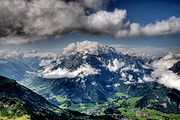
The Glarus Alps are a mountain range
in central Switzerland
. They extend from the Oberalp Pass
to the Klausen Pass
, and are bordered by the Urner Alps
to the west, the Lepontine Alps
to the south and the Appenzell Alps
to the northeast. The eastern part of the Glarus Alps contains a major thrust fault
which was declared a geologic UNESCO world heritage site (the Swiss Tectonic Arena Sardona).
(3,096 m) and Piz Nair
. The name Crispalt is given to a southern, but secondary, peak of Piz Giuv, measuring 3,070 m. West of the main group is the Rienzenstock, while a northern outlyer culminates in the Bristen
. East of the Crispalt, the Kreuzli or Chrüxli Pass separates this from the rather higher mass of the Oberalpstock
(3,328 m).
 Here occurs a partial break in the continuity of the chain. The crest of the snowy range connecting the Oberalpstock with the Tödi
nowhere sinks to 9,000 feet, but makes a sweep convex to the north, forming a semicircular recess, whose numerous torrents are all poured into the Rhine through the Val Russein below Disentis. Two glacier passes lead over this part of the chain — one to west, over the Brunnigletscher to the Maderanertal; the other to the north-east, over the Sand Glacier, to the Linthal
.
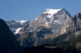
The Tödi
, the highest of the range and of north-eastern Switzerland (3,614 m), is attended by numerous secondary peaks that arise from the extensive snow-fields surrounding the central mountain. A very considerable outlyer, whose chief summits are the Schärhorn and the Gross Windgällen
, belonging to the canton of Uri, is connected with the Tödi by the range of the Clariden
Grat, north to the Hüfi Glacier
. A less important branch encloses the Biferten Glacier
, and terminates in the Selbsanft
, south of Tierfehd. Towards the valley of the Vorderrhein a high promontory stretches nearly due south from the central peaks of the Tödi, and is crowned by the summit of the Piz Posta Biala. Another considerable ramification of the same mass terminates farther to the east in the peak of the Cavistrau
.
The Kisten Pass separates the Tödi group from the Hausstock
, whose summit attains 3,158 m; a branch of this latter group forms the range of the Kärpf
in the canton of Glarus. The Hausstock is cut off from the rather lower but more extended mass of the Vorab
by the Panixer Pass (7,907 ft). Numerous summits, of which the Vorab proper and Piz Grisch
are the most important, approach very near, but do not quite attain to 10,000 feet.
The eastern limit of the latter group is marked by the Segnas Pass — the most frequented of those connecting the Canton Glarus with the Vorderrhein — beyond which arises a wide-stretching mass of rock and glacier, which is part of the Glarus thrust
and culminates at Piz Sardona. This mass is cleft by a deep valley — the Calfeisental: one branch, culminating in the Pizol
(2,844 m), extends east over Pfäfers
, while another, including the highest peak of the canton of St. Gallen
, the Ringelspitz
(3,247 m), runs due east to the low Kunkels Pass (1,357 m), separating this range from the Calanda
.
>
s :
of the Tödi Range, from the Oberalp Pass
to the Klausen Pass
, are:
Mountain range
A mountain range is a single, large mass consisting of a succession of mountains or narrowly spaced mountain ridges, with or without peaks, closely related in position, direction, formation, and age; a component part of a mountain system or of a mountain chain...
in central Switzerland
Switzerland
Switzerland name of one of the Swiss cantons. ; ; ; or ), in its full name the Swiss Confederation , is a federal republic consisting of 26 cantons, with Bern as the seat of the federal authorities. The country is situated in Western Europe,Or Central Europe depending on the definition....
. They extend from the Oberalp Pass
Oberalp Pass
Oberalp Pass is a high mountain pass in the Swiss Alps connecting the cantons of Graubünden and Uri between Disentis and Andermatt.-Winter closure:...
to the Klausen Pass
Klausen Pass
Klausen Pass is a high mountain pass in the Swiss Alps connecting the cantons of Uri and Glarus. The pass road from Altdorf leads through the Schächen Valley, the pass and Urnerboden to Linthal in Glarus....
, and are bordered by the Urner Alps
Urner Alps
The Urner Alps are a mountain range in central Switzerland in the western part of the Alps. They extend into the cantons of Obwalden, Valais, Lucerne, Bern, Uri and Nidwalden and are bordered by the Bernese Alps to the west, the Lepontine Alps to the south and the Glarus Alps to the east.The Urner...
to the west, the Lepontine Alps
Lepontine Alps
The Lepontine Alps are a mountain range in the central part of the Alps. They are located in Switzerland and Italy .On the north the upper Rhône valley separate them from the Bernese Alps and the Furka Pass and the upper Reuss valley separates them from the Urner Alps; on the west the Simplon Pass...
to the south and the Appenzell Alps
Appenzell Alps
The Appenzell Alps are a mountain range in Switzerland on the northern edge of the Alps. They extend into the cantons of Appenzell Ausserrhoden, Appenzell Innerrhoden and St...
to the northeast. The eastern part of the Glarus Alps contains a major thrust fault
Thrust fault
A thrust fault is a type of fault, or break in the Earth's crust across which there has been relative movement, in which rocks of lower stratigraphic position are pushed up and over higher strata. They are often recognized because they place older rocks above younger...
which was declared a geologic UNESCO world heritage site (the Swiss Tectonic Arena Sardona).
Geography
The main chain of the Glarus Alps can be divided into six minor groups, separated from each other by passes, the lowest of which exceeds 7,500 ft. The westernmost of these is the Crispalt, a rugged range including many peaks of nearly equal height. The highest of these are the Piz GiuvPiz Giuv
Piz Giuv is a mountain of the Glarus Alps, located on the border between the cantons of Uri and Graubünden. At 3,096 metres above sea level, it is the highest mountain of the Glarus Alps lying west of the Oberalpstock. Its summit is situated between three valleys: the Fellital and Etzlital on the...
(3,096 m) and Piz Nair
Piz Nair (Tujetsch)
Piz Nair is a mountain in the Glarus Alps, located on the border between the cantons of Uri and Graubünden. Together with Piz Giuv on the west, it overlooks the end of the Etzli valley in the canton of Uri...
. The name Crispalt is given to a southern, but secondary, peak of Piz Giuv, measuring 3,070 m. West of the main group is the Rienzenstock, while a northern outlyer culminates in the Bristen
Bristen
The Bristen is a mountain in the Glarus Alps, overlooking the valley of the Reuss near Gurtnellen in the canton of Uri. The mountain is located about four kilometres north of Piz Giuv and the border with Graubünden. The Bristen is the westernmost three-thousander of the Glarus Alps.-External links:*...
. East of the Crispalt, the Kreuzli or Chrüxli Pass separates this from the rather higher mass of the Oberalpstock
Oberalpstock
The Oberalpstock or Piz Tgietschen is a mountain in the Glarus Alps between the cantons of Uri and Graubünden. Its massif separates the valleys of Maderanertal and Surselva near Sedrun ....
(3,328 m).
Tödi
The Tödi , or Piz Russein, is the highest mountain in the Glarus Alps and the highest summit in the Canton of Glarus, Switzerland. It is located on the border between the cantons of Graubünden and Glarus...
nowhere sinks to 9,000 feet, but makes a sweep convex to the north, forming a semicircular recess, whose numerous torrents are all poured into the Rhine through the Val Russein below Disentis. Two glacier passes lead over this part of the chain — one to west, over the Brunnigletscher to the Maderanertal; the other to the north-east, over the Sand Glacier, to the Linthal
Linthal
Linthal is a former municipality in the canton of Glarus in Switzerland. Effective from 1 January 2011, Linthal is part of the municipality of Glarus Süd.-Geography:...
.
The Tödi
Tödi
The Tödi , or Piz Russein, is the highest mountain in the Glarus Alps and the highest summit in the Canton of Glarus, Switzerland. It is located on the border between the cantons of Graubünden and Glarus...
, the highest of the range and of north-eastern Switzerland (3,614 m), is attended by numerous secondary peaks that arise from the extensive snow-fields surrounding the central mountain. A very considerable outlyer, whose chief summits are the Schärhorn and the Gross Windgällen
Gross Windgällen
The Gross Windgällen is a 3,187 metres high mountain in the Glarus Alps, overlooking the valley of the Reuss in the canton of Uri. The massif of the Gross Wingällen lies between two parallel valleys, the Schächental on the north side and the Maderanertal on the south side, both converging to the...
, belonging to the canton of Uri, is connected with the Tödi by the range of the Clariden
Clariden
The Clariden is a mountain in the Glarus Alps, located between the cantons of Uri and Glarus. While on the north the Clariden overlooks the 1,948 metres high Klausen Pass, the south side is covered by large glaciers: the Hüfifirn on the west and the Claridenfirn on the east....
Grat, north to the Hüfi Glacier
Hüfi Glacier
The Hüfi Glacier is a long glacier situated in the Glarus Alps in the canton of Uri in Switzerland. In 1973 it had an area of .-External links:*...
. A less important branch encloses the Biferten Glacier
Biferten Glacier
The Biferten Glacier is a 4 km long glacier situated in the Glarus Alps in the canton of Glarus in Switzerland. In 1973 it had an area of 2.81 km². The glacier is located east of the Tödi.-External links:*...
, and terminates in the Selbsanft
Selbsanft
The Selbsanft is a mountain in the Glarus Alps, overlooking the valley of Linthal in the canton of Glarus. The Selbsanft is a large mountain consisting of several summits of which the highest is named Hinter Selbsanft. The massif is a buttress of the Bifertenstock and separates the valleys of the...
, south of Tierfehd. Towards the valley of the Vorderrhein a high promontory stretches nearly due south from the central peaks of the Tödi, and is crowned by the summit of the Piz Posta Biala. Another considerable ramification of the same mass terminates farther to the east in the peak of the Cavistrau
Cavistrau
The Cavistrau is a mountain in the Glarus Alps, overlooking Brigels in Graubünden. The mountain consists of several summits of which the highest is named Cavistrau Grond....
.
The Kisten Pass separates the Tödi group from the Hausstock
Hausstock
The Hausstock is a mountain in the Glarus Alps, on the border between the cantons of Glarus and Graubünden. It overlooks the valleys of Linthal and Surselva . The Hausstock was the site of the 1799 withdrawal of the Russian army under General Alexander Suvorov...
, whose summit attains 3,158 m; a branch of this latter group forms the range of the Kärpf
Kärpf
The Kärpf is a mountain in the Glarus Alps, located in the canton of Glarus. The Kärpf is the highest point of the massif lying north of Richetlipass...
in the canton of Glarus. The Hausstock is cut off from the rather lower but more extended mass of the Vorab
Vorab
The Vorab is a mountain in the Glarus Alps, located on the border between the cantons of Glarus and Graubünden. The summit is also named Bündner Vorab to distinguish it from a lower summit named Glarner Vorab...
by the Panixer Pass (7,907 ft). Numerous summits, of which the Vorab proper and Piz Grisch
Piz Grisch
Piz Grisch is a mountain in the Oberhalbstein Range, located in Graubünden, Switzerland.-External links:*...
are the most important, approach very near, but do not quite attain to 10,000 feet.
The eastern limit of the latter group is marked by the Segnas Pass — the most frequented of those connecting the Canton Glarus with the Vorderrhein — beyond which arises a wide-stretching mass of rock and glacier, which is part of the Glarus thrust
Glarus thrust
The Glarus thrust is a major thrust fault in the Alps of eastern Switzerland. Along the thrust the Helvetic nappes were thrusted more than 100 km to the north over the external Aarmassif and Infrahelvetic complex...
and culminates at Piz Sardona. This mass is cleft by a deep valley — the Calfeisental: one branch, culminating in the Pizol
Pizol
The Pizol is a mountain in the Glarus Alps, overlooking Bad Ragaz in the canton of St. Gallen. At 2,844 metres above sea level, it is the highest summit of the chain separating the valleys of the Seez and the Tamina and the highest mountain lying entirely within the canton of St...
(2,844 m), extends east over Pfäfers
Pfäfers
Pfäfers is a municipality in the Wahlkreis of Sarganserland in the canton of St. Gallen in Switzerland. The villages Pfäfers, St. Margrethenberg, Vadura, Valens, Vasön and Vättis belong to the municipality.-History:...
, while another, including the highest peak of the canton of St. Gallen
Canton of St. Gallen
The Canton of St. Gallen is a canton of Switzerland. St. Gallen is located in the north east of Switzerland. It covers an area of 2,026 km², and has a population of . , the population included 97,461 foreigners, or about 20.9% of the total population. The capital is St. Gallen. Spelling...
, the Ringelspitz
Ringelspitz
The Ringelspitz, or Piz Barghis is a mountain in the Glarus Alps, located on the border between the cantons of St. Gallen and Graubünden. It is the highest summit of the canton of St...
(3,247 m), runs due east to the low Kunkels Pass (1,357 m), separating this range from the Calanda
Calanda (mountain)
The Calanda is a mountain in the Glarus Alps with two main peaks Haldensteiner Calanda and Felsberger Calanda , both located on the border between the cantons of St. Gallen and Graubünden in eastern Switzerland...
.
Principal summits
| Name | Metres | Feet |
|---|---|---|
| Tödi Tödi The Tödi , or Piz Russein, is the highest mountain in the Glarus Alps and the highest summit in the Canton of Glarus, Switzerland. It is located on the border between the cantons of Graubünden and Glarus... |
3614 | 11,857 |
| Bifertenstock Bifertenstock The Bifertenstock is a mountain in the Glarus Alps, located between the cantons of Glarus and Graubünden . It overlooks four valleys: the Biferten Glacier valley on the north-west, the Limmern Glacier on the north-east, the Val Punteglias on the south-west and the Val Frisal on the south-east... |
3426 | 11,241 |
| Piz Urlaun Piz Urlaun Piz Urlaun is a mountain in the Glarus Alps, located on the border between the cantons of Glarus and Graubünden. It lies on the ridge between the Tödi and the Bifertenstock. Both sides are covered by glaciers.-External links:*... |
3371 | 11,060 |
| Oberalpstock Oberalpstock The Oberalpstock or Piz Tgietschen is a mountain in the Glarus Alps between the cantons of Uri and Graubünden. Its massif separates the valleys of Maderanertal and Surselva near Sedrun .... |
3330 | 10,926 |
| Gross Schärhorn Gross Schärhorn The Schärhorn is a mountain in the Glarus Alps near Klausen Pass. The highest summit is named Gross Schärhorn while a second summit is named Chli Schärhorn . The mountain overlooks the valley of Schächental on the north side and the Hüfi Glacier in the Maderanertal on the south side. Both valleys... |
3296 | 10,814 |
| Claridenstock | 3270 | 10,729 |
| Düssi Düssi The Düssi is a mountain in the Glarus Alps, located on the border between the cantons of Uri and Graubünden. Its massif separates the valleys of Maderanertal and Val Russein... |
3256 | 10,703 |
| Ringelspitz Ringelspitz The Ringelspitz, or Piz Barghis is a mountain in the Glarus Alps, located on the border between the cantons of St. Gallen and Graubünden. It is the highest summit of the canton of St... |
3251 | 10,667 |
| Cavistrau Cavistrau The Cavistrau is a mountain in the Glarus Alps, overlooking Brigels in Graubünden. The mountain consists of several summits of which the highest is named Cavistrau Grond.... |
3250 | 10,663 |
| Gross Windgällen Gross Windgällen The Gross Windgällen is a 3,187 metres high mountain in the Glarus Alps, overlooking the valley of the Reuss in the canton of Uri. The massif of the Gross Wingällen lies between two parallel valleys, the Schächental on the north side and the Maderanertal on the south side, both converging to the... |
3192 | 10,473 |
| Hausstock Hausstock The Hausstock is a mountain in the Glarus Alps, on the border between the cantons of Glarus and Graubünden. It overlooks the valleys of Linthal and Surselva . The Hausstock was the site of the 1799 withdrawal of the Russian army under General Alexander Suvorov... |
3152 | 10,342 |
| Gross Ruchen Gross Ruchen The Gross Ruchen is a mountain in the Glarus Alps, overlooking the Brunnital south of Unterschächen in the canton of Uri. It is located between the higher Gross Windgallen on the west and the Schärhorn on the east.... |
3136 | 10,289 |
| Piz Segnas Piz Segnas Piz Segnas is a mountain in the Glarus Alps, located on the border between the cantons of Glarus and Graubünden. Piz Sardona is lying on the same ridge to the north, from where the Trinserhorn or Piz Dolf lies to the southeast. The Tschingelhoerner with the famous Martinsloch is next to the west... |
3102 | 10,178 |
| Piz Giuv Piz Giuv Piz Giuv is a mountain of the Glarus Alps, located on the border between the cantons of Uri and Graubünden. At 3,096 metres above sea level, it is the highest mountain of the Glarus Alps lying west of the Oberalpstock. Its summit is situated between three valleys: the Fellital and Etzlital on the... |
3098 | 10,165 |
| Crispalt | 3080 | 10,105 |
| Bristen Bristen The Bristen is a mountain in the Glarus Alps, overlooking the valley of the Reuss near Gurtnellen in the canton of Uri. The mountain is located about four kilometres north of Piz Giuv and the border with Graubünden. The Bristen is the westernmost three-thousander of the Glarus Alps.-External links:*... |
3074 | 10,086 |
| Selbsanft Selbsanft The Selbsanft is a mountain in the Glarus Alps, overlooking the valley of Linthal in the canton of Glarus. The Selbsanft is a large mountain consisting of several summits of which the highest is named Hinter Selbsanft. The massif is a buttress of the Bifertenstock and separates the valleys of the... |
3029 | 9,938 |
| Bündner Vorab Bündner Vorab The Vorab is a mountain in the Glarus Alps, located on the border between the cantons of Glarus and Graubünden. The summit is also named Bündner Vorab to distinguish it from a lower summit named Glarner Vorab... |
3025 | 9,925 |
| Glärnisch Glärnisch The Glärnisch is a mountain of the Glarus Alps, overlooking the valley of the Linth in the canton of Glarus. It consists of several summits of which the highest is distinguished by the name Bächistock, followed by the Vrenelisgärtli and the Ruchen .The massif of the Glärnisch consists of two... |
2914 | 9,560 |
| Tschingelhörner Tschingelhörner Tschingelhörner is a mountain in the Glarus Alps, located on the border between the cantons of Glarus and Graubünden in Switzerland. It is in fact composed of differents summits on a 1 km long ridge, situated south-west of Piz Segnas. The mountain is part of the Swiss Tectonic Arena Sardona... |
2850 | 9,351 |
| Piz Sol Grauehorner | 2849 | 9,348 |
| Calanda Calanda (mountain) The Calanda is a mountain in the Glarus Alps with two main peaks Haldensteiner Calanda and Felsberger Calanda , both located on the border between the cantons of St. Gallen and Graubünden in eastern Switzerland... |
2808 | 9,213 |
| Kärpf Kärpf The Kärpf is a mountain in the Glarus Alps, located in the canton of Glarus. The Kärpf is the highest point of the massif lying north of Richetlipass... |
2797 | 9,177 |
| Piz Alpetta Piz Alpetta Piz Alpetta is a mountain in the Glarus Alps, located near Disentis in the canton of Graubünden, Switzerland.-External links:*... |
2764 | 9,068 |
| Piz Dado Piz Dado Piz Dado is a mountain in the Glarus Alps, located near Brigels in the canton of Graubünden, Switzerland.-External links:*... |
2699 | 8,855 |
| Magerrain Magerrain Magerrain is a mountain in the Glarus Alps. It lies on the border between the cantons of Glarus and St. Gallen in Switzerland.-External links:*... |
2528 | 8,294 |
| Mürtschenstock Mürtschenstock Mürtschenstock is a mountain in the Glarus Alps, located in the Canton of Glarus, Switzerland.-External links:*... |
2442 | 8,012 |
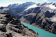
Glaciers
Main glacierGlacier
A glacier is a large persistent body of ice that forms where the accumulation of snow exceeds its ablation over many years, often centuries. At least 0.1 km² in area and 50 m thick, but often much larger, a glacier slowly deforms and flows due to stresses induced by its weight...
s :
- Hüfi GlacierHüfi GlacierThe Hüfi Glacier is a long glacier situated in the Glarus Alps in the canton of Uri in Switzerland. In 1973 it had an area of .-External links:*...
- Limmern GlacierLimmern GlacierThe Limmern Glacier is a 3 km long glacier situated in the Glarus Alps in the canton of Glarus in Switzerland. In 1973 it had an area of 2.09 km².-External links:*...
- Biferten GlacierBiferten GlacierThe Biferten Glacier is a 4 km long glacier situated in the Glarus Alps in the canton of Glarus in Switzerland. In 1973 it had an area of 2.81 km². The glacier is located east of the Tödi.-External links:*...
- Vorab GlacierVorab GlacierThe Vorab Glacier is a 2 km long glacier situated in the Glarus Alps in the cantons of Glarus and Graubünden. It lies on the east side of the Vorab, between 2,600 and 3,000 metres above sea level. In 1973 it had an area of 2.17 km²....
Passes
The chief passesMountain pass
A mountain pass is a route through a mountain range or over a ridge. If following the lowest possible route, a pass is locally the highest point on that route...
of the Tödi Range, from the Oberalp Pass
Oberalp Pass
Oberalp Pass is a high mountain pass in the Swiss Alps connecting the cantons of Graubünden and Uri between Disentis and Andermatt.-Winter closure:...
to the Klausen Pass
Klausen Pass
Klausen Pass is a high mountain pass in the Swiss Alps connecting the cantons of Uri and Glarus. The pass road from Altdorf leads through the Schächen Valley, the pass and Urnerboden to Linthal in Glarus....
, are:
- Note: road status .
| Mountain pass | Location | Type (as of 1911) | Elevation | |
|---|---|---|---|---|
| Clariden Pass | Amsteg to Linthal Linthal Linthal is a former municipality in the canton of Glarus in Switzerland. Effective from 1 January 2011, Linthal is part of the municipality of Glarus Süd.-Geography:... | snow | 2969 meters | 9741 feet |
| Planura Pass | Amsteg to Linthal | snow | 2940 meters | 9646 feet |
| Kammlilucke or Scheerjoch | Maderanertal to Unterschächen Unterschächen Unterschächen is a municipality in the canton of Uri in Switzerland, situated in the upper Schächental.-Geography:Unterschächen has an area, , of . Of this area, 35.6% is used for agricultural purposes, while 9.4% is forested. Of the rest of the land, 0.8% is settled and the remainder is... | snow | 2848 meters | 9344 feet |
| Sardona Pass | Flims Flims Flims is a municipality in the district of Imboden in the Swiss canton of Graubünden. The town of Flims is dominated by the Flimserstein which you can see from almost anywhere in the area.... to Bad Ragaz Bad Ragaz Bad Ragaz is a municipality in the Wahlkreis of Sarganserland in the canton of St. Gallen in Switzerland.It is the home of a famous natural spring and is a popular spa and health resort destination. Bad Ragaz is also surprisingly known as one of the best pizza towns in all of Europe... | snow | 2840 meters | 9318 feet |
| Sand Alp Pass | Disentis to Linthal Linthal Linthal is a former municipality in the canton of Glarus in Switzerland. Effective from 1 January 2011, Linthal is part of the municipality of Glarus Süd.-Geography:... | snow | 2780 meters | 9121 feet |
| Brunni Pass | Disentis to Amsteg | snow | 2736 meters | 8977 feet |
| Segnes Pass | Elm Elm, Switzerland -Culture:In 1981, the Wakker Prize was awarded to Elm for the development and preservation of its architectural heritage.... to Flims Flims Flims is a municipality in the district of Imboden in the Swiss canton of Graubünden. The town of Flims is dominated by the Flimserstein which you can see from almost anywhere in the area.... | foot path | 2625 meters | 8613 feet |
| Kisten Pass | Linthal Linthal Linthal is a former municipality in the canton of Glarus in Switzerland. Effective from 1 January 2011, Linthal is part of the municipality of Glarus Süd.-Geography:... to Ilanz Ilanz Ilanz is a municipality in the district of Surselva in the Swiss canton of Graubünden.-History:Ilanz is first mentioned in 765 as Iliande. Ilanz became the capital of the newly formed Grey League in 1395. The Grey League was the second of Three Leagues which eventually formed canton Graubünden... | bad bridle path | 2500 meters | 8203 feet |
| Panixer Pass | Elm Elm, Switzerland -Culture:In 1981, the Wakker Prize was awarded to Elm for the development and preservation of its architectural heritage.... to Ilanz Ilanz Ilanz is a municipality in the district of Surselva in the Swiss canton of Graubünden.-History:Ilanz is first mentioned in 765 as Iliande. Ilanz became the capital of the newly formed Grey League in 1395. The Grey League was the second of Three Leagues which eventually formed canton Graubünden... | bad bridle path | 2407 meters | 7897 feet |
| Chrüzli Pass | Amsteg to Sedrun | foot path | 2350 meters | 7710 feet |
| Foo or Ramin Pass | Elm Elm, Switzerland -Culture:In 1981, the Wakker Prize was awarded to Elm for the development and preservation of its architectural heritage.... to Weisstannen Weisstannen Weisstannen is a village located in the canton of St. Gallen, Switzerland. It lies in the municipality of Mels, south-west of Sargans.Weisstannen is located at 1,004 metres above sea level on the Seez River in the Weisstannen valley . It lies at the foot of the Pizol.- External links :*... | bridle path | 2222 meters | 7290 feet |
| Oberalp Pass Oberalp Pass Oberalp Pass is a high mountain pass in the Swiss Alps connecting the cantons of Graubünden and Uri between Disentis and Andermatt.-Winter closure:... | Andermatt Andermatt Andermatt is a municipality in the canton of Uri in Switzerland.With Realp and Hospental, it is located in the Urseren valley, south of Altdorf.-Geography:... to Disentis | carriage road | 2048 meters | 6719 feet |
| Klausen Pass Klausen Pass Klausen Pass is a high mountain pass in the Swiss Alps connecting the cantons of Uri and Glarus. The pass road from Altdorf leads through the Schächen Valley, the pass and Urnerboden to Linthal in Glarus.... | Altdorf Altdorf, Switzerland Altdorf is the capital of the Swiss canton of Uri. The municipality covers an area of and is located at a height of above sea-level, to the right of the river Reuss.-Location:... to Linththal | carriage road | 1952 meters | 6404 feet |