

Tweed River (New South Wales)
Encyclopedia
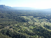
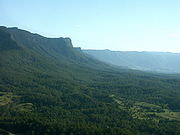
The Tweed River is a short river in the Northern Rivers region of New South Wales
, Australia
. Its drainage basin
consists mostly of the erosion caldera
of the Tweed Volcano
, a huge extinct volcano
of which Mount Warning
is the volcanic plug
. The branches of the river join at Murwillumbah
and flow about 20 kilometres northeast through Tweed Heads
to where they enter the sea south of Point Danger.
The total catchment size of the Tweed River is 1080 km2. The watershed is bordered by the McPherson Range
, Burringbar Range, Condong Range and Tweed Range
. The Tweed River area has a fine subtropical climate, high rainfall and fertile volcanic soils. It was originally covered by rainforest, much of which has been cleared. Some remains in several national parks and reserves. The lowlands along the river are used for farming sugar cane and other crops. The river's tidal influence reaches beyond Murwillumbah to Bray Park Weir.
The surrounding Tweed Shire is also a Local Government Area
of New South Wales. Each year the river hosts a number of major aquatic events. The lower reaches of the Tweed River are a good recreational fishing site. Waterskiing, pleasure boating and rowing are other popular activities on the lower reaches of the river.
and forms part of the border between Queensland
and New South Wales. Even though parts of the river are a few kilometres within the New South Wales side of the border, the expression "North of the Tweed" is used to refer to the people and places of Queensland; likewise, "South of the Tweed" is a term used by Queenslanders regarding the southern states of Australia. The term probably originates from southern Australians' summer vacation trips driving along the Pacific Highway
through the scenic New South Wales North Coast. The highway crosses many rivers along its route, with the Tweed being the last one before reaching the holiday destinations of the Gold Coast
, just on the other side of the Queensland border.
. South of Mount Warning Doon Doon Creek which is dammed by the Clarrie Hall Dam
and Perch Creek enter the Tweed from its southern banks and Byrill Creek joins on the northern side near Terragon. Downstream Korumbyn Creek and then at Byangum the larger Oxley River enters the river, before it flows through Murwillumbah. At Tumbulgum
the Rous River
joins the Tweed. The Terranora and Cobaki creeks enter the Tweed about 2 km upstream from the mouth.
 The estuary of the Tweed River is an important shorebird
habitat.
on the northern end of Letitia Spit that collects sand and then pumps it under the Tweed River to beaches in the neighbouring state of Queensland. Outlets for the Tweed River Entrance Sand Bypassing System include Duranbah Beach, Snapper Rocks East, Snapper Rocks West, Greenmount and Kirra
. Dredging of the navigation entrance is also undertaken regularly as part of the overall sand bypassing program. The width of Tweed River mouth is about 150 m across.
New South Wales
New South Wales is a state of :Australia, located in the east of the country. It is bordered by Queensland, Victoria and South Australia to the north, south and west respectively. To the east, the state is bordered by the Tasman Sea, which forms part of the Pacific Ocean. New South Wales...
, Australia
Australia
Australia , officially the Commonwealth of Australia, is a country in the Southern Hemisphere comprising the mainland of the Australian continent, the island of Tasmania, and numerous smaller islands in the Indian and Pacific Oceans. It is the world's sixth-largest country by total area...
. Its drainage basin
Drainage basin
A drainage basin is an extent or an area of land where surface water from rain and melting snow or ice converges to a single point, usually the exit of the basin, where the waters join another waterbody, such as a river, lake, reservoir, estuary, wetland, sea, or ocean...
consists mostly of the erosion caldera
Caldera
A caldera is a cauldron-like volcanic feature usually formed by the collapse of land following a volcanic eruption, such as the one at Yellowstone National Park in the US. They are sometimes confused with volcanic craters...
of the Tweed Volcano
Tweed Volcano
Tweed Volcano was an early Miocene shield volcano in northeastern New South Wales, Australia. In the course of about three million years, Tweed Volcano was formed over the East Australia hotspot when this part of the continent passed over it around 23 million years ago...
, a huge extinct volcano
Volcano
2. Bedrock3. Conduit 4. Base5. Sill6. Dike7. Layers of ash emitted by the volcano8. Flank| 9. Layers of lava emitted by the volcano10. Throat11. Parasitic cone12. Lava flow13. Vent14. Crater15...
of which Mount Warning
Mount Warning
Mount Warning is a mountain west-south-west of Murwillumbah, near the border with Queensland in the Northern Rivers region of New South Wales, Australia...
is the volcanic plug
Volcanic plug
A volcanic plug, also called a volcanic neck or lava neck, is a volcanic landform created when magma hardens within a vent on an active volcano. When forming, a plug can cause an extreme build-up of pressure if volatile-charged magma is trapped beneath it, and this can sometimes lead to an...
. The branches of the river join at Murwillumbah
Murwillumbah, New South Wales
Murwillumbah is a town of approximately 7,500 people in far north-eastern New South Wales, Australia in the Tweed Shire. It lies on the Tweed River, 848 km north-east of Sydney, 13 km south of the Queensland border and 132 km south of Brisbane. At the 2006 census, Murwillumbah had a...
and flow about 20 kilometres northeast through Tweed Heads
Tweed Heads, New South Wales
Tweed Heads is a town located on the Tweed River in north-eastern New South Wales, Australia in Tweed Shire. Tweed Heads is located next to the border with Queensland, adjacent to the "Twin Town" of Coolangatta, a suburb of the Gold Coast...
to where they enter the sea south of Point Danger.
The total catchment size of the Tweed River is 1080 km2. The watershed is bordered by the McPherson Range
McPherson Range
The McPherson Range is an extensive mountain range, a spur of the Great Dividing Range, heading in an easterly direction from near Wallangarra to the Pacific Ocean coastline. It forms part of the Scenic Rim on the border between the states of New South Wales and Queensland. Further west of the...
, Burringbar Range, Condong Range and Tweed Range
Tweed Range
The Tweed Range is the western extension of the Tweed Volcano caldera rim in northern New South Wales, Australia. The range marks the southern extinct of the Scenic Rim. The Bar Mountain massif is the highest point on the range, rising to 1130 m above sea level...
. The Tweed River area has a fine subtropical climate, high rainfall and fertile volcanic soils. It was originally covered by rainforest, much of which has been cleared. Some remains in several national parks and reserves. The lowlands along the river are used for farming sugar cane and other crops. The river's tidal influence reaches beyond Murwillumbah to Bray Park Weir.
The surrounding Tweed Shire is also a Local Government Area
Local Government Areas of New South Wales
The local government areas of New South Wales, Australia have been subject to periodic bouts of restructuring and rationalisation by the State Government, involving voluntary and involuntary amalgamation of areas...
of New South Wales. Each year the river hosts a number of major aquatic events. The lower reaches of the Tweed River are a good recreational fishing site. Waterskiing, pleasure boating and rowing are other popular activities on the lower reaches of the river.
Naming
The Tweed was named after the River TweedRiver Tweed
The River Tweed, or Tweed Water, is long and flows primarily through the Borders region of Great Britain. It rises on Tweedsmuir at Tweed's Well near where the Clyde, draining northwest, and the Annan draining south also rise. "Annan, Tweed and Clyde rise oot the ae hillside" as the Border saying...
and forms part of the border between Queensland
Queensland
Queensland is a state of Australia, occupying the north-eastern section of the mainland continent. It is bordered by the Northern Territory, South Australia and New South Wales to the west, south-west and south respectively. To the east, Queensland is bordered by the Coral Sea and Pacific Ocean...
and New South Wales. Even though parts of the river are a few kilometres within the New South Wales side of the border, the expression "North of the Tweed" is used to refer to the people and places of Queensland; likewise, "South of the Tweed" is a term used by Queenslanders regarding the southern states of Australia. The term probably originates from southern Australians' summer vacation trips driving along the Pacific Highway
Pacific Highway (Australia)
The Pacific Highway is a major transport route along part of the east coast of Australia and is part of Australia's national route 1.It is 960 km long and links Sydney, the capital of New South Wales, to Brisbane, the capital of Queensland, along the coast, via Gosford, Newcastle, Taree, Port...
through the scenic New South Wales North Coast. The highway crosses many rivers along its route, with the Tweed being the last one before reaching the holiday destinations of the Gold Coast
Gold Coast, Queensland
Gold Coast is a coastal city of Australia located in South East Queensland, 94km south of the state capital Brisbane. With a population approximately 540,000 in 2010, it is the second most populous city in the state, the sixth most populous city in the country, and also the most populous...
, just on the other side of the Queensland border.
Course
The river begins northwest of the village called Lillian Rock. The upper reaches pass through the small villages of Kunghur, Terragon and UkiUki, New South Wales
Uki is a village situated near Mount Warning in the Tweed Valley of far northern New South Wales, Australia in the Tweed Shire. At the 2006 census, Uki had a population of 203 people...
. South of Mount Warning Doon Doon Creek which is dammed by the Clarrie Hall Dam
Clarrie Hall Dam
Clarrie Hall Dam is a dam built across the Doon Doon Creek that creates the artificial Lake Clarrie Hall. The dam is located close to the small town of Uki, New South Wales, Australia....
and Perch Creek enter the Tweed from its southern banks and Byrill Creek joins on the northern side near Terragon. Downstream Korumbyn Creek and then at Byangum the larger Oxley River enters the river, before it flows through Murwillumbah. At Tumbulgum
Tumbulgum
Tumbulgum is a town in northern New South Wales, Australia. The town is in the Tweed Shire local government area, at the confluence of the Rous and Tweed Rivers, north east of the state capital, Sydney and south east of Brisbane...
the Rous River
Rous River
The Rous River is a river in the Northern Rivers region of the state of New South Wales in Australia. It is a tributary of the Tweed River, joining the Tweed at Tumbulgum, northeast of Murwillumbah....
joins the Tweed. The Terranora and Cobaki creeks enter the Tweed about 2 km upstream from the mouth.
Wader
Waders, called shorebirds in North America , are members of the order Charadriiformes, excluding the more marine web-footed seabird groups. The latter are the skuas , gulls , terns , skimmers , and auks...
habitat.
Mouth
There is a sand bypassing system operating at the mouth of the Tweed River. A jettyJetty
A jetty is any of a variety of structures used in river, dock, and maritime works that are generally carried out in pairs from river banks, or in continuation of river channels at their outlets into deep water; or out into docks, and outside their entrances; or for forming basins along the...
on the northern end of Letitia Spit that collects sand and then pumps it under the Tweed River to beaches in the neighbouring state of Queensland. Outlets for the Tweed River Entrance Sand Bypassing System include Duranbah Beach, Snapper Rocks East, Snapper Rocks West, Greenmount and Kirra
Kirra, Queensland
Kirra is a beachside suburb of the Gold Coast in Queensland, Australia. The small rocky headland Kirra Point separates Kirra beach to the north and Coolangatta beach to the south, and is noted as one of the world's premier surf breaks....
. Dredging of the navigation entrance is also undertaken regularly as part of the overall sand bypassing program. The width of Tweed River mouth is about 150 m across.