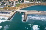
All Topics  
Jetty

 
Jetty

   Email Print
   Bookmark   Link


Jetty


Coastal lagoons fronted by barrier spits
Spit (landform)

A spit is a Deposition landform found off coasts. At one end, spits connect to land, while at the far end they exist in open water. A spit is a type of bar or beach that develops where a re-entrant occurs, such as at cove's headlands, by the process of longshore drift....
 typically have entrances that migrate through time. Here, the entrance has been fixed by jetty variety of structures used in river
River

A river is a natural stream of water, usually freshwater, flowing toward an ocean, a lake, or another stream. In some cases a river flows into the ground or dries up completely before reaching another body of water....
, dock
Dock (maritime)

A dock is a man-made feature involved in the handling of boats or ships. However the exact meaning varies between different variants of the English language....
, and maritime
SEA

See also: Sea and seasThe three-letter acronym SEA may refer to:People/organizations/businesses*Scientists and Engineers for America, a pro-science political advocacy group....
 works which are generally carried out in pairs from river banks, or in continuation of river channels at their outlets into deep water; or out into docks, and outside their entrances; or for forming basin
Basin

Basin may mean:* Drainage basin, hydrological basin or catchment basin, a region of land where water drains downhill into a specified body of water...
s along the sea-coast for port
Port

||-||-|-||-||-||-||-||-||-|}A port is a facility for receiving ships and transferring cargo. They are usually found at the edge of an ocean, sea, river, or lake....
s in tide
Tide

Tides are the rising of Earth's ocean surface caused by the tidal forces of the Moon and the Sun acting on the oceans. Tides cause changes in the depth of the marine and estuary water bodies and produce oscillating currents known as tidal streams, making prediction of tides important for coastal navigation ....
less seas.


Discussion
Ask a question about 'Jetty'
Start a new discussion about 'Jetty'
Answer questions from other users
Full Discussion Forum


Encyclopedia


Jetty Break2 New(usgs)
Coastal lagoons fronted by barrier spits
Spit (landform)

A spit is a Deposition landform found off coasts. At one end, spits connect to land, while at the far end they exist in open water. A spit is a type of bar or beach that develops where a re-entrant occurs, such as at cove's headlands, by the process of longshore drift....
 typically have entrances that migrate through time. Here, the entrance has been fixed by jetty variety of structures used in river
River

A river is a natural stream of water, usually freshwater, flowing toward an ocean, a lake, or another stream. In some cases a river flows into the ground or dries up completely before reaching another body of water....
, dock
Dock (maritime)

A dock is a man-made feature involved in the handling of boats or ships. However the exact meaning varies between different variants of the English language....
, and maritime
SEA

See also: Sea and seasThe three-letter acronym SEA may refer to:People/organizations/businesses*Scientists and Engineers for America, a pro-science political advocacy group....
 works which are generally carried out in pairs from river banks, or in continuation of river channels at their outlets into deep water; or out into docks, and outside their entrances; or for forming basin
Basin

Basin may mean:* Drainage basin, hydrological basin or catchment basin, a region of land where water drains downhill into a specified body of water...
s along the sea-coast for port
Port

||-||-|-||-||-||-||-||-||-|}A port is a facility for receiving ships and transferring cargo. They are usually found at the edge of an ocean, sea, river, or lake....
s in tide
Tide

Tides are the rising of Earth's ocean surface caused by the tidal forces of the Moon and the Sun acting on the oceans. Tides cause changes in the depth of the marine and estuary water bodies and produce oscillating currents known as tidal streams, making prediction of tides important for coastal navigation ....
less seas. The forms and construction of these jetties are as varied as their uses; for though they invariably extend out into water, and serve either for directing a current
Current (fluid)

File:Water patterns.JPGA current, in a river or stream, is the flow of water influenced by gravity as the water moves downhill to reduce its potential energy....
 or for accommodating vessels, they are sometimes formed of high open timber-work, sometimes of low solid projections, and occasionally only differ from breakwater
Breakwater (structure)

Breakwaters are structures constructed on coasts as part of coastal management or to protect an anchorage from the effects of weather and longshore drift....
s
in their object. The term derived from the French word
French language

French is a Romance language spoken around the world by around 80 million people as first language, by 190 million as second language, and by about another 200 million people as an acquired tongue, with significant speakers in 54 countries....
 jetée, "to throw", and signifies something thrown out. Jetties at the coast that have been raised and extended, help prevent long shore drift, so therefore prevent coastal erosion.

For regulating rivers

Formerly jetties of timber-work were very commonly extended out, opposite one another, from each bank of a river, at intervals, to contract a wide channel
Channel (geography)

In physical geography, a channel is the physical confine of a river, slough or ocean strait consisting of a bed and banks.A channel is also the natural or man-made deeper course through a reef, bar , bay, or any shallow body of water....
, and by concentration of the current to produce a deepening

For berthing at docks

Where dock
Dock (maritime)

A dock is a man-made feature involved in the handling of boats or ships. However the exact meaning varies between different variants of the English language....
s are given sloping sides, openwork timber jetties are generally carried across the slope, at the ends of which vessels can lie in deep water or more solid structures are erected over the slope for supporting coal-tips. Pilework jetties are also constructed in the water outside the entrances to docks on each side, so as to form an enlarging trumpet-shaped channel between the entrance, lock or tidal basin and the approach channel, in order to guide vessels in entering or leaving the docks. Solid jetties, moreover, lined with quay walls, are sometimes carried out into a wide dock, at right angles to the line of quays at the side, to enlarge the accommodation; and they also serve, when extended on a large scale from the coast of a tideless sea under shelter of an outlying breakwater, to form the basins in which vessels lie when discharging and taking in cargoes in such a port as Marseilles.

At entrances to jetty harbors

The approach channel to some ports situated on sand
Sand

Sand is a naturally occurring granular material composed of finely divided rock and mineral particles.As the term is used by geologists, sand particles range in diameter from 0.0625 to 2 millimeters....
y coasts is guided and protected across the beach by parallel jetties, made solid up to a little above low water of neap tide
Tide

Tides are the rising of Earth's ocean surface caused by the tidal forces of the Moon and the Sun acting on the oceans. Tides cause changes in the depth of the marine and estuary water bodies and produce oscillating currents known as tidal streams, making prediction of tides important for coastal navigation ....
s, on which open timber-work is erected, provided with a planked platform at the top raised above the highest tides. The channel between the jetties was originally maintained by tidal scour
Tidal scour

Tidal scour is an erosion process which is carried out by the tidal movement of water.Examples of this hydrological process can be found in many areas of the world....
 from low-lying areas close to the coast, and subsequently by the current from sluicing
Sluice

A sluice is a water channel that is controlled at its head by a gate . For example, a millrace is a sluice that channels water toward a water mill....
 basins; but it is now often considerably deepened by sand-pump dredging
Dredge

Dredging is an excavation activity or operation usually carried out at least partly underwater, in shallow seas or fresh water areas with the purpose of gathering up bottom sediments and disposing of them at a different location....
. It is protected to some extent by the solid portion of the jetties from the inroad of sand from the adjacent beach, and from the levelling action of the waves; whilst the upper open portion serves to indicate the channel, and to guide the vessels if necessary (see Harbor
Harbor

A harbor or harbour , or haven, is a place where ships may shelter from the weather or are stored. Harbors can be man-made or natural....
). The bottom part of the older jetties, in such long-established jetty ports as Calais
Calais

Calais is a town in northern France in the Departments of France of Pas-de-Calais, of which it is a sub-prefecture. Although Calais is by far the largest city in Pas-de-Calais, the department's capital is its third-largest city of Arras....
, Dunkirk
Dunkirk

Dunkirk is a Communes of France in the Nord Departments of France in northern France.It lies 10 kilometres from the Belgium border. Population of the city at the 1999 census was 70,850 inhabitants ....
 and Ostend
Ostend

||-||-||}Ostend  is a Belgium city and Municipalities in Belgium located in the Flemish Region Provinces of Belgium of West Flanders....
 was composed of clay
Clay

Clay is a naturally occurring material composed primarily of fine-grained minerals, which show plasticity through a variable range of water content, and which can be hardened when dried and/or fired....
 or rubble stone, covered on the top by fascine-work or pitching: but the deepening of the jetty channel by dredging, and the need which arose for its enlargement - led to the reconstruction of the jetties at these ports. The nes jetties at Dunkirk were founded in the sandy beach, by the aid of compressed air, at a depth of 22 3/4 ft. below low water of spring tides; and their solid masonry portion, on a concrete foundation was raised 50 ft. above low water of neap tides.

At lagoon outlets

A small tidal rise spreading tidal water over a large expanse of lagoon or inland back-water causes the influx and efflux of the tide to maintain a deep channel through a narrows no longer confined by a bank on each side, becomes dispersed, and owing to the reduction of its scouring force, is no longer able at a moderate distance from the shore effectually to resist the action of tending to form a continuous beach in front of the outlet. Hence a bar
Bar (landform)

A shoal or sandbar is a somewhat linear landform within or extending into a body of water, typically composed of sand, silt or small pebbles....
 is produced which diminishes the available depth in the approach channel. By carrying out a solid jetty over the bar, however on each side of the outlet, the tidal currents are concentrated in the channel across the bar, and lower it by scour. Thus the available depth of the approach channels to Venice
Venice

Venice is a city in northern Italy, the capital city of the Italian regions Veneto, a population of 271,251 . Together with Padua, Italy, the city is included in the Padua-Venice Metropolitan Area ....
 through the Malaniocco and Lido outlets from the Venetian lagoon have been deepened several feet over their bars by jetties of rubble, carried out across the foreshore into deep water on both sides of the channel. Other examples are provided by the long jetties extended into the sea in front of the entrance to Charleston
Charleston, South Carolina

Charleston is a city in Charleston County, South Carolina in the U.S. state of South Carolina. It is the largest city and county seat of Charleston County....
 harbour, formerly constructed of fascines, weighted with stone and logs, but subsequently of rubble stone, and by the two converging rubble jetties carried out from each shore of Dublin bay for deepening the approach to Dublin
Dublin

Dublin is both the largest city and capital of Republic of Ireland. It is located near the midpoint of Ireland's east coast, at the mouth of the River Liffey and at the centre of the Dublin Region....
 harbour.

Rivers


At the outlet of tideless rivers

Jetties have been constructed on each side of the outlet river
River

A river is a natural stream of water, usually freshwater, flowing toward an ocean, a lake, or another stream. In some cases a river flows into the ground or dries up completely before reaching another body of water....
 of some of the rivers flowing into the Baltic
Baltic Sea

The Baltic Sea is a brackish inland sea located in Northern Europe, from 53?N to 66?N latitude and from 20?E to 26?E longitude. It is bounded by the Scandinavian Peninsula, the mainland of Europe, and the Denmark islands....
, with the objects of prolonging the scour of the river and protecting the channel from being shoaled by the littoral
Littoral

In coastal environments and biomes, the littoral zone extends from the high water mark, which is rarely inundated, to shoreline areas that are permanently submerged....
 drift along the shore. The most interesting application of parallel jetties is in lowering the bar in front of one of the mouths of a deltaic river flowing into a tide - a virtual prolongation of its less sea, by extending the scour of the river out to the bar by banks. Jetties prolonging the Sulina branch of the Danube
Danube

The Danube is the longest river in the European Union and Europe's second longest river after the Volga.The river originates in the Black Forest in Germany as the much smaller Brigach and Breg River rivers which join at the eponymously named German town Donaueschingen, after which it is known as the Danube and flows eastwards for a distance...
 into the Black Sea
Black Sea

The Black Sea is an inland sea sea bounded by southeastern Europe, the Caucasus and the Anatolia and is ultimately connected to the Atlantic Ocean via the Mediterranean Sea and Aegean Seas and various straits....
, and the south pass of the Mississippi
Mississippi

Mississippi is a U.S. state located in the Deep South of the United States. Jackson, Mississippi is the state capital and largest city. The state's name comes from the Mississippi River, which flows along its western boundary, and takes its name from the Anishinaabe language word misi-ziibi ....
 into the Gulf of Mexico
Gulf of Mexico

The Gulf of Mexico is the ninth largest body of water in the world. Considered a smaller part of the Atlantic Ocean, it is an oceanic basin largely surrounded by the North American continent and the island of Cuba....
, formed of rubble stone and concrete blocks, and respectively, have enabled the discharge of these rivers to scour away the bars obstructing the access to them; and they have also carried the sediment-bearing waters sufficiently far out to come under the influence of littoral
Littoral

In coastal environments and biomes, the littoral zone extends from the high water mark, which is rarely inundated, to shoreline areas that are permanently submerged....
 currents, which, by conveying away some of the sediment, postpone the eventual formation of a fresh bar farther out (River engineering
River engineering

River engineering is the process of planned human intervention in the course, characteristics or flow of a river with the intention of producing some defined benefit....
).

At the mouth of tidal rivers

Where a river is narrow near its mouth, and its discharge is generally feeble, the sea is liable on an exposed coast, when the tidal range is small, to block up its outlet during severe storms. The river is thus forced to seek another exit at a weak spot of the beach, which along a low coast may be at some distance off; and this new outlet in its turn may be blocked up, so that the river from time to time shifts the position of its mouth. This inconvenient cycle of changes may be stopped by fixing the outlet of the river at a suitable site, by carrying a jetty on each side of this outlet across the beach, thereby concentrating its discharge in a definite channel and protecting the mouth from being blocked up by littoral drift. This system was long ago applied to the shifting outlet of the river Yare
River Yare

The River Yare is a river in the England county of Norfolk. In its lower reaches the river connects with the navigable waterways of The Broads....
 to the south of Yarmouth
Great Yarmouth

Great Yarmouth, often known to locals as Yarmouth, is a coastal town in Norfolk, England. It is at the mouth of the River Yare, 20 miles east of Norwich....
, and has also been successfully employed for fixing the wandering mouth of the Adur near Shoreham
Shoreham-by-Sea

Shoreham-by-Sea is a small town, port and seaside resort, also being the major settlement in the Adur District of West Sussex in South East England....
, and of the Adour flowing into the Bay of Biscay
Bay of Biscay

The Bay of Biscay is a Headlands and bays of the North Atlantic Ocean. It lies along the western coast of France from Brest, France south to the Spain border, and the northern coast of Spain west to Punta de Estaca de Bares, and is named for the Spanish province of Biscay....
 below Bayonne. When a new channel was cut across the Hoek van Holland
Hoek van Holland

The Hook of Holland , also known in English as the Hook, is a town in South Holland in the Netherlands. It is situated on the North Sea coast, on the north bank of the Nieuwe Waterweg ship canal....
 to provide a straighter and deeper outlet channel for the river Maas
Maas

Maas is a Dutch language and Low German surname allegedly from a short form of Thomas .Many believe Maas to be a shortened Americanized form of the surname Moskowitz...
, forming the approach channel to Rotterdam
Rotterdam

Rotterdam ; city and municipality in the Netherlands province of South Holland, situated in the west of the Netherlands. The municipality is the List of cities in the Netherlands with over 100,000 people in the country, with a population of 584,046 on 1 January 2007 and comprises the southern part of the Randstad, the List of metropolitan are...
, low, broad, parallel jetties, composed of fascine mattresses weighted with stone, were carried across the foreshore into the sea on either side of the new mouth of the river, to protect the jetty channel from littoral drift, and cause the discharge of the river to maintain it out to deep water. The channel, also, beyond the outlet of the river Nervion into the Bay of Biscay
Bay of Biscay

The Bay of Biscay is a Headlands and bays of the North Atlantic Ocean. It lies along the western coast of France from Brest, France south to the Spain border, and the northern coast of Spain west to Punta de Estaca de Bares, and is named for the Spanish province of Biscay....
 has been regulated by jetties; and by extending the south-west jetty out for nearly half a mile with a curve concave towards the channel the outlet has not only been protected to some extent from the easterly drift, but the bar in front has been lowered by the scour produced by the discharge of the river following the concave bend of the south-west jetty. As the outer portion of this jetty was exposed to westerly storms from the Bay of Biscay before the outer harbour was constructed, it has been given the form and strength of a breakwater situated in shallow water.

See also

  • Dock (maritime)
    Dock (maritime)

    A dock is a man-made feature involved in the handling of boats or ships. However the exact meaning varies between different variants of the English language....
  • Groyne
    Groyne

    A groyne is a rigid hydraulic structure built from an ocean shore or from a bank that interrupts water flow and limits the movement of sediment....
  • Jettied floors
    Jettying

    Jettying is a building technique used in medieval timber framing buildings in which an upper floor projects beyond the dimensions of the floor below....
     in medieval houses.
  • Mole
    Mole (architecture)

    A mole is a massive structure, usually of Rock , used as a pier, Breakwater , or junction between places separated by water.Historically, the term "mole" was used in the San Francisco Bay Area in California to refer to the combined structure of a causeway and wooden pier or trestle extending out from the eastern shore and utilized by vario...
  • Pier
    Pier

    A pier is a raised walkway over water, supported by widely spread piles or column. The lighter structure of a pier allows tides and currents to flow almost unhindered, whereas the more solid foundations of a quay or the closely-spaced piles of a wharf can act as breakwaters, and are consequently more liable to silting....
  • Port
    Port

    ||-||-|-||-||-||-||-||-||-|}A port is a facility for receiving ships and transferring cargo. They are usually found at the edge of an ocean, sea, river, or lake....
  • Quay
    Quay

    A quay is a wharf or bank where ships and other vessels are loaded. A quay may be constructed parallel or perpendicular to the bank of a waterway....
  • Wharf
    Wharf

    A wharf is a landing place or pier where ships may tie up and load or unload.A wharf commonly comprises a fixed platform, often on pile. They often serve as interim storage areas with warehouses, since the typical objective is to unload and reload vessels as quickly as possible....