
.gif)
Pacific Highway (Australia)
Encyclopedia

Australia
Australia , officially the Commonwealth of Australia, is a country in the Southern Hemisphere comprising the mainland of the Australian continent, the island of Tasmania, and numerous smaller islands in the Indian and Pacific Oceans. It is the world's sixth-largest country by total area...
and is part of Australia's national route 1
Highway 1 (Australia)
Australia's Highway 1 is a network of highways that circumnavigate the Australian continent, joining all mainland state capitals. At a total length of approximately it is the longest national highway in the world, longer than the Trans-Siberian Highway and the Trans-Canada Highway...
.
It is 960 km long and links Sydney
Sydney
Sydney is the most populous city in Australia and the state capital of New South Wales. Sydney is located on Australia's south-east coast of the Tasman Sea. As of June 2010, the greater metropolitan area had an approximate population of 4.6 million people...
, the capital of New South Wales
New South Wales
New South Wales is a state of :Australia, located in the east of the country. It is bordered by Queensland, Victoria and South Australia to the north, south and west respectively. To the east, the state is bordered by the Tasman Sea, which forms part of the Pacific Ocean. New South Wales...
, to Brisbane
Brisbane
Brisbane is the capital and most populous city in the Australian state of Queensland and the third most populous city in Australia. Brisbane's metropolitan area has a population of over 2 million, and the South East Queensland urban conurbation, centred around Brisbane, encompasses a population of...
, the capital of Queensland
Queensland
Queensland is a state of Australia, occupying the north-eastern section of the mainland continent. It is bordered by the Northern Territory, South Australia and New South Wales to the west, south-west and south respectively. To the east, Queensland is bordered by the Coral Sea and Pacific Ocean...
, along the coast, via Gosford, Newcastle, Taree, Port Macquarie, Kempsey, Coffs Harbour, Grafton, Ballina and the Gold Coast.
History
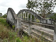
Initially, the primary mode of transport of the coastal areas between Sydney and Brisbane was by boat. From the roads radiating out from the port towns, the intervening hills were eventually crossed to create a continuous route along the coast, but this did not occur until the first decade of the 20th century. By contrast a continuous inland route from Newcastle to Brisbane via the tabelelands had been in existence since the 1840s. A direct coastal route between Sydney and Newcastle was not completed until 1930, and completion of the sealing of the Pacific Highway did not occur until 1958 (at Koorainghat, south of Taree). The last of the many ferries across the coastal rivers was not superseded by a bridge until 1966 (the Harwood Bridge across the south channel of the Clarence River - the north channel had been bridged in 1931).In 1928 the road from Sydney to Newcastle (still under construction) was proclaimed as part of the Great Northern Highway, and the road from Hexham to Tweed Heads as the North Coast Highway. In 1931 the full length from Sydney to Brisbane was proclaimed as the Pacific Highway.
Until the 1990s most road freight between Sydney and Brisbane passed along the New England Highway
New England Highway
The New England Highway is a highway in Australia running from Hexham near Newcastle at its southern end to Yarraman near Toowoomba at its northern end. At its southern end it connects to the Pacific Highway and at its northern end it connects to the D'Aguilar Highway. It traverses the Hunter...
instead, due to the easier topography of the Northern Tablelands it traverses. Between 1950 and 1967, traffic on the Pacific Highway quadrupled due to the attraction of coastal towns between Sydney and Brisbane for retirement living and tourism.
Bus
A bus is a road vehicle designed to carry passengers. Buses can have a capacity as high as 300 passengers. The most common type of bus is the single-decker bus, with larger loads carried by double-decker buses and articulated buses, and smaller loads carried by midibuses and minibuses; coaches are...
accidents on the Pacific Highway in 1989 near Grafton
Grafton bus crash
The Grafton bus crash killed 21 people and injured 22 on the Pacific Highway on the North Coast of New South Wales near Grafton. At some time between 3:50 a.m. and 4:00 a.m. on Friday, 20 October 1989 a southbound semi-trailer truck carrying a load of tinned fruit juice veered onto the wrong side...
(in which 20 people died) and at Clybucca near Kempsey
Kempsey bus crash
The Kempsey bus crash occurred in Australia on December 22, 1989 when two full tourist coaches, each travelling at 100km/h, collided head-on on the Pacific Highway at Clybucca Flat, 12 km north of Kempsey, New South Wales. The collision killed both drivers instantly. The impact snapped seats from...
(in which 35 people died) resulted in a public outcry over the poor quality of the road and its high fatality rate. The Pacific Highway was never part of the Federally funded system of National Highways
National Highway (Australia)
thumb|right|150px|The National Highway Shield in NSW, QLD, WA, NT & TAS.The National Highway is a system of roads connecting all the States and Territories of Australia, and is the major network of highways connecting Australia's largest and most important cities.The National Highway was...
. This appears to be because when the Commonwealth funding of the 'national highway' system began in 1974, the longer New England Highway was chosen rather than the Pacific Highway as the Sydney-Brisbane link due to its easier topography and consequent lower upgrade costs.
Yet the highway was undeniably heavily used by interstate traffic and its upgrade was beyond the resources of the New South Wales Government
Government of New South Wales
The form of the Government of New South Wales is prescribed in its Constitution, which dates from 1856, although it has been amended many times since then...
alone. The NSW Government and the Commonwealth Government argued for years about how the responsibility for funding the highway's upgrade should be divided between themselves, only coming up with a mutually acceptable upgrade package just after the 1996/1997 financial year. The Highway is now part of the AusLink
AusLink
AusLink was an Australian Government land transport funding program, established in June 2004 and administered by the Department of Transport and Regional Services. In 2009 it was replaced with the Nation Building Program under the Nation Building Program Act 2009...
National Network and new projects are funded 50/50 by the Federal and State governments.
Current status
Single carriageway sections from Tweed HeadsTweed Heads, New South Wales
Tweed Heads is a town located on the Tweed River in north-eastern New South Wales, Australia in Tweed Shire. Tweed Heads is located next to the border with Queensland, adjacent to the "Twin Town" of Coolangatta, a suburb of the Gold Coast...
to Newcastle
Newcastle, New South Wales
The Newcastle metropolitan area is the second most populated area in the Australian state of New South Wales and includes most of the Newcastle and Lake Macquarie Local Government Areas...
are progressively being converted to freeway or dual carriageway
Dual carriageway
A dual carriageway is a class of highway with two carriageways for traffic travelling in opposite directions separated by a central reservation...
standards. Numerous sections of single carriageway road have been upgraded by the addition of sections of overtaking lane and pavement widening. Many towns have been bypassed by freeway-standard stretches, though the highway still snakes through several large towns such as Coffs Harbour
Coffs Harbour, New South Wales
-History:By the early 1900s, the Coffs Harbour area had become an important timber production centre. Before the opening of the North Coast Railway Line, the only way to transport large items of heavy but low value, such as timber, was by coastal shipping. This meant sawmillers on the North Coast...
and Kempsey
Kempsey, New South Wales
Kempsey is a town in the Mid North Coast region of New South Wales, Australia and is the council seat for Kempsey Shire. It is located 15 kilometres inland from the coast of the Pacific Ocean where the Pacific Highway and the North Coast railway line cross the Macleay River...
. Overall the highway has become safer and travelling times have been substantially reduced particularly during holiday periods. However, about 50% (333 km) of the Pacific Hwy is still only one lane in each direction with some form of overtaking opportunity occasionally (or three lanes undivided on occasions), 50% (333 km) is dual carriageway and a further 15% (150 km) of dual carriageway is under construction. From time to time, there are proposals in the media for the private sector
Private sector
In economics, the private sector is that part of the economy, sometimes referred to as the citizen sector, which is run by private individuals or groups, usually as a means of enterprise for profit, and is not controlled by the state...
to build a fully controlled-access high-speed tollway between Newcastle and the Queensland border, possibly using the BOT
Build-Operate-Transfer
Build-own-operate-transfer or build-operate-transfer is a form of project financing, wherein a private entity receives a concession from the private or public sector to finance, design, construct, and operate a facility stated in the concession contract...
system of infrastructure provision. Nothing has eventuated from these proposals.
The Pacific Highway was replaced by the Sydney-Newcastle Freeway as the national route between Sydney
Sydney
Sydney is the most populous city in Australia and the state capital of New South Wales. Sydney is located on Australia's south-east coast of the Tasman Sea. As of June 2010, the greater metropolitan area had an approximate population of 4.6 million people...
and Black Hill
Black Hill, New South Wales
Black Hill is a rural locality and suburb of Newcastle, New South Wales, Australia, located northwest of Newcastle's central business district. It is part of the City of Newcastle and City of Cessnock local government areas.-External links:...
in sections between 1965 and 1993. Dual carriageway extends from the New England Highway at Beresfield
Beresfield, New South Wales
Beresfield is a north-western suburb of Newcastle, New South Wales, Australia, located from Newcastle's central business district. It is part of the City of Newcastle local government area.The suburb of Beresfield had a population of 3,118 in 2006....
near the end of the freeway north to a point 3 kilometres south of Bulahdelah, with the section immediately south of Bulahdelah having been completed in October 2009. That section will join with the dual carriageway Bulahdelah bypass currently under construction and due for completion in late 2012. North of Buladelah the Pacific Highway is dual carriageway for 163 km (101.3 mi) from to the Oxley Highway
Oxley Highway
The Oxley Highway is a rural highway in New South Wales, Australia. It starts at Nevertire where it joins the Mitchell Highway. It links Warren, Gilgandra, Coonabarabran, Gunnedah, Carroll, Tamworth, Bendemeer, Walcha, Yarrowitch, Ellenborough, Long Flat, Wauchope and ends at Port Macquarie on the...
interchange.
North of the Oxley Highway there are dual carriageway sections from Eungai-Warrell Creek, North Urunga to Coffs Harbour, the Coffs Harbour urban area (not freeway standard - but still 4 lanes) and a short section at Halfway Creek. From the Ewingsdale interchange
Interchange (road)
In the field of road transport, an interchange is a road junction that typically uses grade separation, and one or more ramps, to permit traffic on at least one highway to pass through the junction without directly crossing any other traffic stream. It differs from a standard intersection, at which...
(the Byron Bay
Byron Bay, New South Wales
Byron Bay is a beachside town located in the far-northeastern corner of the state of New South Wales, Australia. It is located north of Sydney and south of Brisbane. Cape Byron, a headland adjacent to the town, is the easternmost point of mainland Australia. At the 2006 Census, the town had a...
exit) the Pacific Highway is dual carriageway for the remainder of its length to Brisbane. This section of the highway has just one traffic signal, at Banora Point (or Sextons Hill) which will be bypassed following the completion of the Banora Point Upgrade currently under construction and due for completion in late 2012. Projects currently under construction are the Kempsey
Kempsey, New South Wales
Kempsey is a town in the Mid North Coast region of New South Wales, Australia and is the council seat for Kempsey Shire. It is located 15 kilometres inland from the coast of the Pacific Ocean where the Pacific Highway and the North Coast railway line cross the Macleay River...
Bypass (due for completion in mid 2013), Sapphire- Woolgoolga
Woolgoolga, New South Wales
Woolgoolga is a town on the Mid North Coast of New South Wales, Australia. It is on the Pacific Highway, approximately 550 km north of Sydney and 400 km south of Brisbane. The closest city to Woolgoolga is Coffs Harbour, which lies 25.8 km to the south. Woolgoolga has two beaches on...
Upgrade (due for completion in 2014), Glenugie Upgrade (nearing completion), Ballina
Ballina, New South Wales
Ballina is a town on the Northern Rivers of New South Wales, Australia, and the seat of the Ballina Shire Local Government Area. It had a population of 16,477 in the 2006 Census.-Location:...
Bypass (nearing completion) and the Tintenbar
Tintenbar, New South Wales
Tintenbar is a village located on the Far North Coast of New South Wales .Administratively it is part of the Ballina Shire. It is located about or a 9 minutes car drive north-west from Ballina along the Pacific Highway...
- Ewingsdale Upgrade. Construction of the 17 kilometre Tintenbar
Tintenbar, New South Wales
Tintenbar is a village located on the Far North Coast of New South Wales .Administratively it is part of the Ballina Shire. It is located about or a 9 minutes car drive north-west from Ballina along the Pacific Highway...
- Ewingsdale commenced in late 2011. The upgrade includes a new alignment between Tintenbar and Ewingsdale and a twin-tube road tunnel
Tunnel
A tunnel is an underground passageway, completely enclosed except for openings for egress, commonly at each end.A tunnel may be for foot or vehicular road traffic, for rail traffic, or for a canal. Some tunnels are aqueducts to supply water for consumption or for hydroelectric stations or are sewers...
under St Helena Hill
St Helena Tunnel
The St Helena Tunnel is a proposed twin-tube road tunnel under St Helena Hill located near the settlement of Ewingsdale, New South Wales, Australia. The tunnel is part of the proposed Pacific Highway new alignment between Tintenbar and Ewingsdale....
is expected to be completed in 2014.
Environmental impact assessments have been completed for the following future projects:
Warrell Creek to Urunga upgrade,
Oxley Highway to Kempsey.
Preferred routes have been selected for the following future projects:
Woodburn to Ballina Upgrade,
Wells Crossing to Iluka Road,
Woolgoolga to Wells Crossing
F3 Freeway to Raymond Terrace Upgrade.
The Coffs Harbour bypass is currently in planning and a traffic master plan for the Tweed includes:
- Banora Point deviation (2.5 km) - In 2010-2015
- 4-way (full diamond) access ramps of Kirkwook Road - In 2015-2020
- The Tweed Heads/Tugun bypass (5 km) widening to six lanes (3 lanes in each direction) - In 2020-2025.
These projects form part of a 2009-2016 program jointly funded on a 50-50 basis by the Commonwealth and NSW governments to upgrade the Hexham-Gold Coast stretch of the Pacific Highway to dual-carriageway standard.
The five major objectives for the Pacific Highway upgrade are:
- Four lanes from Brisbane to Ewingsdale Interchange (Byron Bay exit) by 2007 - Completed.
- Four lanes from north Urunga to Coffs Harbour by 2008. Completed
- Four lanes from Sydney to Oxley Highway Interchange (Port Macquarie exit) by 2009 (except for Bulahdelah and the approaches to Bulahdelah).
- Four lanes from Brisbane to Ballina by 2014.
- Four lanes for all the rest of the Pacific Highway by 2016.
In 2007 mounting pressure was place on the Federal Government to provide additional funding for the highway. On 10 October 2007 the Federal Minister for Transport and Regional Services pledged $2.4 billion in funding for the highway, subject to dollar for dollar funding by the NSW state government. However, the NSW state government refused to match funding. In the lead up to the 2007 Federal election, then opposition leader Kevin Rudd
Kevin Rudd
Kevin Michael Rudd is an Australian politician who was the 26th Prime Minister of Australia from 2007 to 2010. He has been Minister for Foreign Affairs since 2010...
pledged $1.5 billion in funding. As part of Auslink 2 (Nation Building Program)
AusLink
AusLink was an Australian Government land transport funding program, established in June 2004 and administered by the Department of Transport and Regional Services. In 2009 it was replaced with the Nation Building Program under the Nation Building Program Act 2009...
, the Federal Govt announced in its 2009 Federal budget that $3.1 billion would be spent on the highway up until 2014 at which time just 63% of the highway would be duplicated. The NSW Government will spend just $500 million over that same period, with $300 million cut as a result of the 2008 mini budget.
Safety
The Pacific Highway is one of the most dangerous and deadly stretches of road in Australia. Between 1995 and 2009, over 400 people died on the highway. In 1989, two separate bus crashes, the Grafton bus crashGrafton bus crash
The Grafton bus crash killed 21 people and injured 22 on the Pacific Highway on the North Coast of New South Wales near Grafton. At some time between 3:50 a.m. and 4:00 a.m. on Friday, 20 October 1989 a southbound semi-trailer truck carrying a load of tinned fruit juice veered onto the wrong side...
(in which 20 people died) and the Kempsey bus crash
Kempsey bus crash
The Kempsey bus crash occurred in Australia on December 22, 1989 when two full tourist coaches, each travelling at 100km/h, collided head-on on the Pacific Highway at Clybucca Flat, 12 km north of Kempsey, New South Wales. The collision killed both drivers instantly. The impact snapped seats from...
(in which 35 died), led to the deaths of 55 people on the highway, two of the worst road accidents in Australia's history. In 2009 thus far, 20 people have died on the Pacific Highway. It is estimated that perhaps over 10,000 people have been injured on the highway throughout its history.
Much of the danger of the Pacific Highway lies in the fact that it contains long stretches of undivided road along which all types of vehicles, including private automobiles, buses, vans and trucks, simultaneously travel at speeds approaching and in excess of 100 km/h. Being undivided, there is a very high risk of head-on collisions. A lack of funding has resulted in minimal upgrades to the highway throughout its history. In more recent years, state and federal governments have begun to fund an upgrade to a fully divided highway along its entire length. As of 2009, 44% of the highway has been divided and a further 50 km section is currently being upgraded.
Route description
From Sydney the Pacific Highway starts as the continuation of the Bradfield HighwayBradfield Highway, Sydney
The Bradfield Highway is a highway in Sydney, New South Wales, Australia. At 2.4 km long it is one of the shortest highways in Australia....
at the northern end of the Sydney Harbour Bridge
Sydney Harbour Bridge
The Sydney Harbour Bridge is a steel through arch bridge across Sydney Harbour that carries rail, vehicular, bicycle and pedestrian traffic between the Sydney central business district and the North Shore. The dramatic view of the bridge, the harbour, and the nearby Sydney Opera House is an iconic...
, immediately north of the Sydney Central Business District
Central business district
A central business district is the commercial and often geographic heart of a city. In North America this part of a city is commonly referred to as "downtown" or "city center"...
and is the main route as far as the suburb of Wahroonga
Wahroonga, New South Wales
Wahroonga is a suburb on the Upper North Shore of Sydney, in the state of New South Wales, Australia. Wahroonga is located 22 kilometres north-west of the Sydney central business district, in the local government area of Ku-ring-gai Council and Hornsby Shire....
. From the Harbour Bridge to the Gore Hill Freeway
Gore Hill Freeway
The Gore Hill Freeway is a major freeway in Sydney, New South Wales, Australia. This freeway forms part of Metroad 1 andthe Sydney Orbital Network to provide access to most of the suburbs in Sydney and is also a major route to the north, south, east and west of the metropolis.It connects to the...
at Artarmon
Artarmon, New South Wales
Artarmon is a suburb on the lower North Shore of Sydney, in the state of New South Wales, Australia. Artarmon is located 9 kilometres north-west of the Sydney central business district, in the local government area of the City of Willoughby.-History:...
it has no route number and from the Gore Hill Freeway to Wahroonga it is designated as Metroad 1
Metroad 1
Metroad 1 is a Metroad in Sydney, New South Wales, Australia. It replaced National Route 1, from Metroad 7 at Pearces Corner in Wahroonga south-east to the CBD then from the CBD south-west to the F6 Southern Freeway at Waterfall in October 1993.-Route:...
. From Wahroonga to Hexham near Newcastle the Pacific Highway has been superseded by the Sydney-Newcastle Freeway
Sydney-Newcastle Freeway
The Sydney-Newcastle Freeway is a stretch of motorway linking Sydney to the Central Coast, Newcastle and Hunter regions of New South Wales. It is part of the AusLink road corridor between Sydney and Brisbane, carrying the route designation....
, known formerly and still colloquially as the F3. The present designation of this road is National Highway
National Highway (Australia)
thumb|right|150px|The National Highway Shield in NSW, QLD, WA, NT & TAS.The National Highway is a system of roads connecting all the States and Territories of Australia, and is the major network of highways connecting Australia's largest and most important cities.The National Highway was...
1. The freeway ends at John Renshaw Drive at Beresfield, from which a connector road leads to the New England Highway
New England Highway
The New England Highway is a highway in Australia running from Hexham near Newcastle at its southern end to Yarraman near Toowoomba at its northern end. At its southern end it connects to the Pacific Highway and at its northern end it connects to the D'Aguilar Highway. It traverses the Hunter...
(national highway 15) between Hexham and Maitland
Maitland, New South Wales
Maitland is a city in the Lower Hunter Valley of New South Wales, Australia and the seat of Maitland City Council, situated on the Hunter River approximately by road north of Sydney and north-west of Newcastle...
. Northbound traffic turns right onto a short section John Renshaw Drive then connect via an overpass to the New England Highway
New England Highway
The New England Highway is a highway in Australia running from Hexham near Newcastle at its southern end to Yarraman near Toowoomba at its northern end. At its southern end it connects to the Pacific Highway and at its northern end it connects to the D'Aguilar Highway. It traverses the Hunter...
towards Newcastle, to rejoin the Pacific Highway at Hexham interchange.
Back at Wahroonga, the Pacific Highway itself is located mostly parallel to the freeway until Kariong
Kariong, New South Wales
Kariong is a locality of the Central Coast region of New South Wales, Australia, located to the west of Gosford along the Central Coast Highway. It is part of the City of Gosford local government area.Kariong in the local Original language means meeting place...
(at which point it diverts into the Central Coast through Gosford and Wyong). It continues along this route (designated state route 83) until Doyalson
Doyalson, New South Wales
Doyalson is a suburb of the Central Coast region of New South Wales, Australia. It is part of the Wyong Shire local government area....
. The section of the highway from Cowan to Kariong follows a scenic winding route. This section was damaged quite severely during severe weather in June 2007. Five people died when a bridge over Piles Creek collapsed and the entire section was closed due to subsidence two kilometres further south. The road was reopened in 2009 when the Holt-Bragg Bridge
Holt-Bragg Bridge
Holt-Bragg Bridge is an arch bridge that crosses Piles Creek at Somersby on the Central Coast of New South Wales, Australia as part of the Pacific Highway. It became open on 30 June 2009 as a replacement for the previous bridge that collapsed two years earlier during severe weather...
was opened, named after the family that had perished. The section of what was formerly the Pacific Highway from the Wiseman's Ferry Road junction at Somersby, through to the Pacific Hwy exit at Gosford (adjacent to Brian McGowan Bridge), has been rebadged as the Central Coast Highway
Central Coast Highway
The Central Coast Highway is a major road corridor through the Central Coast region of New South Wales. The route was officially named by the New South Wales state government on 9 August 2006 and aims to provide an easily identifiable route through the Coast for visitors to the region...
, still carrying State Route 83.
Between 1925 and 1930 the then-Main Roads Board reconstructed a route between Hornsby
Hornsby, New South Wales
* Highest Maximum Temperature: 42 °C* Lowest Maximum Temperature: 4.9 °C* Warmest Month: January* Coolest Month: July* Highest Precipitation: February* Lowest Precipitation: July-Notable residents:...
and Calga that had been abandoned some forty years earlier, in order to provide a direct road link between Sydney and Newcastle. In addition a replacement route, from Calga into the gorge of Mooney Mooney Creek and up to the ridge at Kariong
Kariong, New South Wales
Kariong is a locality of the Central Coast region of New South Wales, Australia, located to the west of Gosford along the Central Coast Highway. It is part of the City of Gosford local government area.Kariong in the local Original language means meeting place...
above Gosford, was also required. This new Sydney-Newcastle route via Calga and Gosford was some 80 km shorter than the previous route via Parramatta
Parramatta, New South Wales
Parramatta is a suburb of Sydney, in the state of New South Wales, Australia. It is located in Greater Western Sydney west of the Sydney central business district on the banks of the Parramatta River. Parramatta is the administrative seat of the Local Government Area of the City of Parramatta...
, McGraths Hill
McGraths Hill, New South Wales
McGraths Hill is a suburb of Sydney, in the state of New South Wales, Australia. It is located 44 kilometres north-west of the Sydney central business district in the local government area of the City of Hawkesbury.-External links:...
, Maroota
Maroota, New South Wales
Maroota is a suburb in Sydney, New South Wales, Australia. Maroota is located 83 kilometres northwest of the Sydney central business district, in the local government areas of The Hills Shire and Hornsby Shire....
, Wisemans Ferry
Wisemans Ferry, New South Wales
Wisemans Ferry is a town north of Sydney, in the state of New South Wales, Australia. Wisemans Ferry is located 75 kilometres north-west of the Sydney central business district in the local government areas of Hornsby Shire, The Hills Shire, City of Hawkesbury and City of Gosford.The town is a...
, Wollombi
Wollombi, New South Wales
Wollombi is a small village in the Hunter Region of New South Wales, Australia. It is within the Cessnock City Council LGA, situated southwest of Cessnock and north of Sydney...
and Cessnock
Cessnock, New South Wales
Cessnock is a city in the Hunter Region of New South Wales, Australia, about by road west of Newcastle. It is the administrative centre of the Cessnock City Council LGA and was named after an 1826 grant of land called Cessnock Estate, which was owned by John Campbell...
. At first Peats Ferry was reinstituted to cross the Hawkesbury River
Hawkesbury River
The Hawkesbury River, also known as Deerubbun, is one of the major rivers of the coastal region of New South Wales, Australia. The Hawkesbury River and its tributaries virtually encircle the metropolitan region of Sydney.-Geography:-Course:...
, with construction of the bridge not beginning until 1938, due to the Great Depression
Great Depression
The Great Depression was a severe worldwide economic depression in the decade preceding World War II. The timing of the Great Depression varied across nations, but in most countries it started in about 1929 and lasted until the late 1930s or early 1940s...
. Due to the onset of World War II
World War II
World War II, or the Second World War , was a global conflict lasting from 1939 to 1945, involving most of the world's nations—including all of the great powers—eventually forming two opposing military alliances: the Allies and the Axis...
, the Peats Ferry Bridge
Peats Ferry Bridge
The 'Peats Ferry Bridge' is a road bridge which crosses the Hawkesbury River north of Sydney in New South Wales, Australia.The Peats Ferry Bridge was opened in 1945 and was the first direct road link between Sydney and Newcastle, New South Wales and the north of the State. Before the bridge was...
was not completed until May 1945.
The highway recommences as state route 83 in Gosford and continues north through the Central Coast suburbs of Ourimbah
Ourimbah, New South Wales
Ourimbah is a small township and a suburb of the Central Coast region of New South Wales, Australia, located about north of the Sydney CBD. The township today consists of small scattered local shops and businesses along the Pacific Highway, as well as the Central Coast campus of the University of...
and Wyong
Wyong, New South Wales
Wyong was proclaimed a town in 1888 and is currently a major northern suburb of the Central Coast region of New South Wales, located approximately 89 km NNE of Sydney. It is the administrative centre for the Wyong Shire local government area.- History :...
as a regional route before meeting with a spur of the Sydney-Newcastle Freeway near Doyalson numbered as state route 111. At this point the Pacific Highway becomes state route 111, and is a four-lane regional highway passing Lake Macquarie
Lake Macquarie (New South Wales)
Lake Macquarie is Australia's largest coastal salt water lake, covering an area of in the Hunter Region of New South Wales with most of the City of Lake Macquarie's residents living near its shores. It is connected to the Tasman Sea by a short channel. Lake Macquarie is twice as large as Sydney...
and on through the suburbs of Newcastle
Newcastle, New South Wales
The Newcastle metropolitan area is the second most populated area in the Australian state of New South Wales and includes most of the Newcastle and Lake Macquarie Local Government Areas...
before rejoining national route 1 at Hexham
Hexham, New South Wales
Hexham is a suburb of the city of Newcastle, about inland from Newcastle in New South Wales, Australia on the bank of the Hunter River.Settlement occurred at Hexham in the 1820s when the land was granted to Edward Sparke...
.
From Bennetts Green
Bennetts Green, New South Wales
Bennetts Green is a suburb of the City of Lake Macquarie in New South Wales, Australia, located southwest of Newcastle's central business district on the eastern side of Lake Macquarie....
to Sandgate
Sandgate, New South Wales
Sandgate is a suburb of Newcastle, New South Wales, Australia, located from Newcastle's central business district. It is part of the City of Newcastle local government area.It has a railway station on the Hunter Line....
it is supplemented by the Newcastle Inner City Bypass
Newcastle Inner City Bypass
The Newcastle Inner City Bypass is a ring road in Newcastle New South Wales, Australia. Alternate titles include State Highway 23, Main Road 123 and H23....
, through New Lambton
New Lambton, New South Wales
New Lambton is a suburb of Newcastle, New South Wales, located west of the city centre. Its eastern boundary is the Great Northern Railway, where it is served by Adamstown railway station...
and Jesmond
Jesmond, New South Wales
Jesmond is a suburb of the City of Newcastle LGA, located about west of the Newcastle CBD in the Hunter Region of New South Wales, Australia. It is both a commercial centre and residential area catering to Newcastle residents including Australian and international students attending the University...
. Two lengths of this route (Bennetts Green-Kotara Heights and Jesmond-Shortland) have been replaced by freeway.
From Hexham, the Pacific Highway (now national route 1 again) passes along the NSW North Coast and across the state border into Queensland at Tweed Heads
Tweed Heads, New South Wales
Tweed Heads is a town located on the Tweed River in north-eastern New South Wales, Australia in Tweed Shire. Tweed Heads is located next to the border with Queensland, adjacent to the "Twin Town" of Coolangatta, a suburb of the Gold Coast...
, on the southern fringe of the Gold Coast, Queensland
Gold Coast, Queensland
Gold Coast is a coastal city of Australia located in South East Queensland, 94km south of the state capital Brisbane. With a population approximately 540,000 in 2010, it is the second most populous city in the state, the sixth most populous city in the country, and also the most populous...
. From here, the Highway is a divided four-lane urban arterial to Billinga, where it becomes the Pacific Motorway
Pacific Motorway
The Pacific Motorway is a 100 km long motorway in Australia between Brisbane, Queensland, and the New South Wales-Queensland border at Tweed Heads. The motorway starts at Coronation Drive at Milton in Brisbane, and from 2008 links the Tweed Heads bypass in New South Wales...
. The former route of the Pacific Highway through Burleigh Heads
Burleigh Heads, Queensland
Burleigh Heads is a suburb on the Gold Coast in Queensland, Australia. At the 2006 Census, Burleigh Heads had a population of 7,606.Burleigh Heads is renowned for its surf break, and is an alternative to the more tourist ridden towns of the Gold Coast...
, Surfers Paradise
Surfers Paradise, Queensland
Surfers Paradise is a suburb on the Gold Coast in Queensland, Australia. At the 2006 Census, Surfers Paradise had a population of 18,501....
and Southport
Southport, Queensland
-Sport:The Southport Sharks Australian rules football club has a presence in the area, including a club and function centre.-Transport:The Broadwaterway is a foreshoreway that encourages pedestrians and cyclists to travel along the Broadwater foreshores of Southport.A ferry terminal is planned for...
was renamed the Gold Coast Highway
Gold Coast Highway
The Gold Coast Highway in Queensland, Australia links the coastal suburbs of the Gold Coast. 33 km in length, the highway passes through popular tourist resorts such as Southport, Surfers Paradise, Burleigh Heads and Currumbin...
.
Interchanges
Interchanges on motorway standard sections, from north to south. Pacific Highway  Tweed Heads to Ewingsdale Tweed Heads to Ewingsdale |
||
| Northbound exits | Distance from Sydney Sydney Sydney is the most populous city in Australia and the state capital of New South Wales. Sydney is located on Australia's south-east coast of the Tasman Sea. As of June 2010, the greater metropolitan area had an approximate population of 4.6 million people... (km) |
Southbound exits |
| End Pacific Highway continues on as Pacific Motorway Pacific Motorway The Pacific Motorway is a 100 km long motorway in Australia between Brisbane, Queensland, and the New South Wales-Queensland border at Tweed Heads. The motorway starts at Coronation Drive at Milton in Brisbane, and from 2008 links the Tweed Heads bypass in New South Wales... to Brisbane Brisbane Brisbane is the capital and most populous city in the Australian state of Queensland and the third most populous city in Australia. Brisbane's metropolitan area has a population of over 2 million, and the South East Queensland urban conurbation, centred around Brisbane, encompasses a population of... |
829 Brisbane 102 km |
Burleigh Heads Burleigh Heads, Queensland Burleigh Heads is a suburb on the Gold Coast in Queensland, Australia. At the 2006 Census, Burleigh Heads had a population of 7,606.Burleigh Heads is renowned for its surf break, and is an alternative to the more tourist ridden towns of the Gold Coast... , Surfers Paradise Surfers Paradise, Queensland Surfers Paradise is a suburb on the Gold Coast in Queensland, Australia. At the 2006 Census, Surfers Paradise had a population of 18,501.... Gold Coast Airport Gold Coast Airport Gold Coast Airport, or Coolangatta Airport, is an Australian domestic and international airport on the Gold Coast and is located some south of Brisbane and 25 km south of Surfers Paradise. The entrance to the airport is situated in the suburb of Bilinga on the Gold Coast... Gold Coast Highway Gold Coast Highway The Gold Coast Highway in Queensland, Australia links the coastal suburbs of the Gold Coast. 33 km in length, the highway passes through popular tourist resorts such as Southport, Surfers Paradise, Burleigh Heads and Currumbin... |
| Tweed Heads Tweed Heads, New South Wales Tweed Heads is a town located on the Tweed River in north-eastern New South Wales, Australia in Tweed Shire. Tweed Heads is located next to the border with Queensland, adjacent to the "Twin Town" of Coolangatta, a suburb of the Gold Coast... , Coolangatta Coolangatta, Queensland Coolangatta is the southernmost suburb of the Gold Coast, Queensland, Australia. It has a population of 4,869 and is named after the schooner Coolangatta which was wrecked there in 1846.... , Gold Coast Airport Gold Coast Airport Gold Coast Airport, or Coolangatta Airport, is an Australian domestic and international airport on the Gold Coast and is located some south of Brisbane and 25 km south of Surfers Paradise. The entrance to the airport is situated in the suburb of Bilinga on the Gold Coast... Gold Coast Highway Gold Coast Highway The Gold Coast Highway in Queensland, Australia links the coastal suburbs of the Gold Coast. 33 km in length, the highway passes through popular tourist resorts such as Southport, Surfers Paradise, Burleigh Heads and Currumbin... , Kennedy Drive |
Start Pacific Highway End Start |
|
| Tweed Heads Tweed Heads, New South Wales Tweed Heads is a town located on the Tweed River in north-eastern New South Wales, Australia in Tweed Shire. Tweed Heads is located next to the border with Queensland, adjacent to the "Twin Town" of Coolangatta, a suburb of the Gold Coast... , Coolangatta Coolangatta, Queensland Coolangatta is the southernmost suburb of the Gold Coast, Queensland, Australia. It has a population of 4,869 and is named after the schooner Coolangatta which was wrecked there in 1846.... Kennedy Drive |
||
| Tweed Heads Tweed Heads, New South Wales Tweed Heads is a town located on the Tweed River in north-eastern New South Wales, Australia in Tweed Shire. Tweed Heads is located next to the border with Queensland, adjacent to the "Twin Town" of Coolangatta, a suburb of the Gold Coast... , Coolangatta Coolangatta, Queensland Coolangatta is the southernmost suburb of the Gold Coast, Queensland, Australia. It has a population of 4,869 and is named after the schooner Coolangatta which was wrecked there in 1846.... Minjungbal Drive |
960 | Tweed Heads Tweed Heads, New South Wales Tweed Heads is a town located on the Tweed River in north-eastern New South Wales, Australia in Tweed Shire. Tweed Heads is located next to the border with Queensland, adjacent to the "Twin Town" of Coolangatta, a suburb of the Gold Coast... , Coolangatta Coolangatta, Queensland Coolangatta is the southernmost suburb of the Gold Coast, Queensland, Australia. It has a population of 4,869 and is named after the schooner Coolangatta which was wrecked there in 1846.... Minjungbal Drive |
| Banora Point Darlington Drive |
Banora Point Darlington Drive |
|
| Sexton Hill Traffic Lights Sydney 824 km Banora Point, Terranora Terranora, New South Wales Terranora is a suburb of Tweed Heads on the northern boundary of New South Wales, Australia. At the 2006 census, Terranora had a population of 3,137 people.The town is part of the Tweed Shire local Government area. Its postcode is 2486... Terranora Road |
||
| Barneys Point Old Pacific Highway |
823 | Barneys Point Old Pacific Highway |
| Tweed River - Barneys Point Bridge | ||
| Chinderah Chinderah, New South Wales Chinderah is a suburb in the Tweed Shire. It is located south of Tweed Heads and next to the seaside township of Kingscliff. An industrial estate, golf course and small shopping precinct are located within the area.... , Kingscliff Kingscliff, New South Wales Kingscliff is a coastal town just south of Tweed Heads in the Northern Rivers region of New South Wales, Australia, and is part of Tweed Shire. At the 2006 census, Kingscliff had a population of 6,016 people.... , Fingal Head Fingal Head, New South Wales Fingal Head was first sighted by James Cook about 17:15 EST 15–16 May 1770 . The area and small town is often just called Fingal. It is located on the Far North Coast of New South Wales in Tweed Shire, about 5 km south of the New South Wales and Queensland border, and south of the Gold Coast... Waugh Street |
822 | Chinderah Chinderah, New South Wales Chinderah is a suburb in the Tweed Shire. It is located south of Tweed Heads and next to the seaside township of Kingscliff. An industrial estate, golf course and small shopping precinct are located within the area.... , Kingscliff Kingscliff, New South Wales Kingscliff is a coastal town just south of Tweed Heads in the Northern Rivers region of New South Wales, Australia, and is part of Tweed Shire. At the 2006 census, Kingscliff had a population of 6,016 people.... , Fingal Head Fingal Head, New South Wales Fingal Head was first sighted by James Cook about 17:15 EST 15–16 May 1770 . The area and small town is often just called Fingal. It is located on the Far North Coast of New South Wales in Tweed Shire, about 5 km south of the New South Wales and Queensland border, and south of the Gold Coast... Tweed Coast Way |
| Chinderah Chinderah, New South Wales Chinderah is a suburb in the Tweed Shire. It is located south of Tweed Heads and next to the seaside township of Kingscliff. An industrial estate, golf course and small shopping precinct are located within the area.... , Kingscliff Kingscliff, New South Wales Kingscliff is a coastal town just south of Tweed Heads in the Northern Rivers region of New South Wales, Australia, and is part of Tweed Shire. At the 2006 census, Kingscliff had a population of 6,016 people.... Tweed Coast Way |
820 | Chinderah Chinderah, New South Wales Chinderah is a suburb in the Tweed Shire. It is located south of Tweed Heads and next to the seaside township of Kingscliff. An industrial estate, golf course and small shopping precinct are located within the area.... , Cudgen, Casuarina, BP Service Centre Tweed Coast Way |
| Cudgen, Condong, Murwillumbah Murwillumbah, New South Wales Murwillumbah is a town of approximately 7,500 people in far north-eastern New South Wales, Australia in the Tweed Shire. It lies on the Tweed River, 848 km north-east of Sydney, 13 km south of the Queensland border and 132 km south of Brisbane. At the 2006 census, Murwillumbah had a... Tweed Valley Way |
817 | Condong, Murwillumbah Murwillumbah, New South Wales Murwillumbah is a town of approximately 7,500 people in far north-eastern New South Wales, Australia in the Tweed Shire. It lies on the Tweed River, 848 km north-east of Sydney, 13 km south of the Queensland border and 132 km south of Brisbane. At the 2006 census, Murwillumbah had a... Tweed Valley Way |
| Cabarita Beach, Bogangar Bogangar, New South Wales Bogangar is a town in the Northern Rivers region of New South Wales, Australia in Tweed Shire. In 2006, the town had a population of 3,050 people, including 2,555 Australian-born persons and 100 indigenous persons.- References :... Clothiers Creek Road |
808 | Cabarita Beach, Bogangar Bogangar, New South Wales Bogangar is a town in the Northern Rivers region of New South Wales, Australia in Tweed Shire. In 2006, the town had a population of 3,050 people, including 2,555 Australian-born persons and 100 indigenous persons.- References :... Clothiers Creek Road |
| Hastings Point, Potsville Pottsville, New South Wales Pottsville is a town in the Northern Rivers region of New South Wales, Australia in Tweed Shire. At the 2006 census, Pottsville had a population of 3,298.Bill Potts owned the first house in Pottsville around 1930 and the location was initially named Potts Point... Cudgera Creek Road |
801 | Hastings Point, Potsville Pottsville, New South Wales Pottsville is a town in the Northern Rivers region of New South Wales, Australia in Tweed Shire. At the 2006 census, Pottsville had a population of 3,298.Bill Potts owned the first house in Pottsville around 1930 and the location was initially named Potts Point... Cudgera Creek Road |
| Sleepy Hollow rest area | 798 | Sleepy Hollow rest area |
| Murwillumbah Murwillumbah, New South Wales Murwillumbah is a town of approximately 7,500 people in far north-eastern New South Wales, Australia in the Tweed Shire. It lies on the Tweed River, 848 km north-east of Sydney, 13 km south of the Queensland border and 132 km south of Brisbane. At the 2006 census, Murwillumbah had a... , Mooball Mooball, New South Wales Burringbar is a small town south-east of Murwillumbah in the Northern Rivers region of New South Wales, Australia.... , Burringbar Tweed Valley Way |
789 | Billinudgel Billinudgel, New South Wales Billinudgel is a town in the Northern Rivers region of New South Wales, Australia, and is part of Byron Shire. It used to be a railway town with many fruits and vegetable loaded onto the local railway. Since the railway was not longer used in Billinudgel it has nearly joined to the nearby town of... , Ocean Shores Ocean Shores, New South Wales Ocean Shores is a coastal town in the Northern Rivers region of New South Wales. Since being established in the early 1970s it has grown to a reasonable size town. It is the largest town north Byron Bay in the Byron Shire and second largest in the shire. It is located in the Brunswick Valley - a... , Mooball Mooball, New South Wales Burringbar is a small town south-east of Murwillumbah in the Northern Rivers region of New South Wales, Australia.... Tweed Valley Way |
| Billinudgel Billinudgel, New South Wales Billinudgel is a town in the Northern Rivers region of New South Wales, Australia, and is part of Byron Shire. It used to be a railway town with many fruits and vegetable loaded onto the local railway. Since the railway was not longer used in Billinudgel it has nearly joined to the nearby town of... Wilfred Street |
786 | no exit |
| Brunswick River | ||
| Brunswick Heads Brunswick Heads, New South Wales Brunswick Heads is a town on the north coast of New South Wales, Australia in Byron Shire. In 2006, the town had a population of 1,614 people.... , Ocean Shores Ocean Shores, New South Wales Ocean Shores is a coastal town in the Northern Rivers region of New South Wales. Since being established in the early 1970s it has grown to a reasonable size town. It is the largest town north Byron Bay in the Byron Shire and second largest in the shire. It is located in the Brunswick Valley - a... Brunswick Valley Way |
783 | Brunswick Heads Brunswick Heads, New South Wales Brunswick Heads is a town on the north coast of New South Wales, Australia in Byron Shire. In 2006, the town had a population of 1,614 people.... Brunswick Valley Way |
| Brunswick Heads Brunswick Heads, New South Wales Brunswick Heads is a town on the north coast of New South Wales, Australia in Byron Shire. In 2006, the town had a population of 1,614 people.... , Mullumbimby Mullumbimby, New South Wales Mullumbimby is a town in the Northern Rivers region of New South Wales, Australia in Byron Shire, and is colloquially referred to as The Biggest Little Town in Australia. It lies at the foot of Mount Chincogan in the Brunswick Valley about from the sea... Brunswick Valley Way, Gulgan Road |
780 | Mullumbimby Mullumbimby, New South Wales Mullumbimby is a town in the Northern Rivers region of New South Wales, Australia in Byron Shire, and is colloquially referred to as The Biggest Little Town in Australia. It lies at the foot of Mount Chincogan in the Brunswick Valley about from the sea... Brunswick Valley Way, Gulgan Road |
| Mullumbimby Mullumbimby, New South Wales Mullumbimby is a town in the Northern Rivers region of New South Wales, Australia in Byron Shire, and is colloquially referred to as The Biggest Little Town in Australia. It lies at the foot of Mount Chincogan in the Brunswick Valley about from the sea... Gulgan Road |
777 | Mullumbimby Mullumbimby, New South Wales Mullumbimby is a town in the Northern Rivers region of New South Wales, Australia in Byron Shire, and is colloquially referred to as The Biggest Little Town in Australia. It lies at the foot of Mount Chincogan in the Brunswick Valley about from the sea... Gulgan Road |
| Ewingsdale, Byron Bay Byron Bay, New South Wales Byron Bay is a beachside town located in the far-northeastern corner of the state of New South Wales, Australia. It is located north of Sydney and south of Brisbane. Cape Byron, a headland adjacent to the town, is the easternmost point of mainland Australia. At the 2006 Census, the town had a... Ewingsdale Road |
771 Brisbane 162 km |
Ewingsdale, Byron Bay Byron Bay, New South Wales Byron Bay is a beachside town located in the far-northeastern corner of the state of New South Wales, Australia. It is located north of Sydney and south of Brisbane. Cape Byron, a headland adjacent to the town, is the easternmost point of mainland Australia. At the 2006 Census, the town had a... Ewingsdale Road |
| Start Motorway End Start  |
End Motorway continues on as to Ballina Ballina, New South Wales Ballina is a town on the Northern Rivers of New South Wales, Australia, and the seat of the Ballina Shire Local Government Area. It had a population of 16,477 in the 2006 Census.-Location:... and Sydney Sydney Sydney is the most populous city in Australia and the state capital of New South Wales. Sydney is located on Australia's south-east coast of the Tasman Sea. As of June 2010, the greater metropolitan area had an approximate population of 4.6 million people... |
|
Speed limits (south to north)
Hexham to Port Macquarie- Hexham bridges - 80 km/h northbound / 60 km/h southbound
- Hexham bridges to Motto Farm - 80 km/h
- Motto Farm to Raymond Terrace bypass - 70 km/h
- Raymond Terrace bypass to 1km north of Seven Mile Creek - 110 km/h
- Seven Mile Creek to Medowie Road - 100 km/h northbound / 110 km/h southbound
- Medowie Road to 1km east of the Bucketts Way at-grade intersection - 100 km/h
- 1km east of the Bucketts Way at-grade intersection to South Bulahdelah - 110 km/h
- South Bulahdelah - 80 km/h
- Bulahdelah - Mainly 60 km/h and 40 km/h at the school near Lee Street, within school times
- Bulahdelah bypass - 110 km/h (Construction of the bypass to be completed in mid-2012)
- North Bulahdelah - 90 km/h
- North Bulahdelah to Wootton Way (North) - 110 km/h
- Wootton Way (North) to Coolongnook - 100 km/h
- Coolongolook - 80 km/h
- Coolongolook to Possum Brush - 100 km/h (in-between Trittion Road and Stills Road, northbound only - 90 km/h)
- Possum Brush to just north of Cundletown Interchange - 110 km/h
- Just north of Cundletown Interchange to just north of Herons Creek - 100 km/h
- Just north of Herons Creek to Oxley Hwy interchange (Port Macquarie exit) - 110 km/h (in-between Herons Creek and Stills Road, northbound only - 80 km/h)
Port Macquarie to Coffs Harbour
- Oxley Hwy interchange to Hastings River Bridge - 80 km/h
- Hastings River Bridge to Kempsey - 100 km/h (fixed speed camera near Kundabung)
- Kempsey town area - 50–80 km/h (3 Traffic lights)
- Kempsey to Frederickton - 100 km/h
- Frederickton town area - 50 km/h (Sharp curves)
- Frederickton to Macksville - 100 km/h (40 km/h school zone at Bellimbopinni, many bends at Warrell Creek)
- Macksville town area - 50 km/h (Sharp bend, narrow bridge and traffic light)
- Macksville to Nambucca Heads - 100 km/h (fixed speed camera 6 km south of Nambucca Heads)
- Nambucca Heads town area - 60 km/h
- Nambucca Heads to Valla Beach - 100 km/h
- Valla Beach to Urunga - 80 km/h (fixed speed camera near Hungry Head turnoff)
- Urunga town area - 60 km/h (fixed speed camera)
- Urunga to Boambee - 100 km/h (including Bonville Deviation/Upgrade)
- Boambee to Coffs Harbour - 70 km/h
Coffs Harbour to Ballina
- Coffs Harbour town area - 60 km/h (approx 12 traffic lights, heavy traffic area)
- Coffs Harbour to Korora - 80 km/h
- Korora to Sandy Beach north turn off - 100 km/h (fixed speed camera at Korora)
- Sandy Beach north turn off to Woolgoolga - 80 km/h
- Woolgoolga town area - 60 km/h (roundabout)
- Woolgoolga to Grafton - 100 km/h (Kangaroos 5 to 20 km south of Grafton, Horses near Corindi, 3 km divided road at Halfway creek)
- Grafton town area - 60 km/h (Centenary Drive or High Level Bypass - 80 km/h)
- Grafton to Ulmarra - 100 km/h
- Ulmarra town area - 50 km/h (School Zone 40 km/h, sharp curves)
- Ulmarra to Clarence River Bridge (Maclean) - 100 km/h
- Clarence River Bridge - 80 km/h (fixed speed camera, opening bridge)
- Clarence River Bridge (Harwood Island) to Woodburn - 100 km/h (25 km of kangaroo zone)
- Woodburn town area - 50 km/h (fixed speed camera at northern end of town)
- Woodburn to Broadwater - 100 km/h
- Broadwater town area - 50 km/h
- Broadwater to Wardell - 100 km/h
- Wardell town area (including Richmond River Bridge) - 80 km/h (fixed speed camera at northern edge of Wardell)
- Wardell to Pimlico Road 100 km/h
- Pimlico Road to Teven Road 80 km/h
- Teven Road to Ballina - 60 km/h
Ballina to Brisbane
- Ballina - 60 km/h (7 roundabouts, 4 traffic lights) (Bypass currently under construction)
- Ballina to Cumbalum - 80 km/h (Construction works)
- Cumbalum to Tintenbar (northern section of Ballina Bypass open to traffic) - 100 km/h
- Tintenbar to Knockrow - 90 km/h
- Knockrow to Newrybar - 100 km/h
- Newrybar to Bangalow Bypass - 80 km/h
- Bangalow Bypass to Coolamon Scenic Drive - 100 km/h
- Coolamon Scenic Drive to Macleods Shoot - 80 km/h
- Macleods Shoot to Ewingsdale interchage (Byron Bay exit) - 60 km/h (fixed speed camera, 140 m climb/descent)
- Ewingsdale interchage (Byron Bay exit) to Mullumbimby/Brunswick Heads Interchange - 100 km/h
- Mullumbimby/Brunswick Heads Interchange to Chinderah - 110 km/h
- Chinderah to Banora Point - 100 km/h (Southbound Only) 90 km/h (Northbound only)
- Banora Point - 70 km/h (Construction of the bypass will be completed in mid-2012)
- Sexton Hill (just north of Banora Point) - 80 km/h
- Sexton Hill to Nerang - 100 km/h (including the Tugun bypass) - Reduced roadwork speed limits at different places during Nerang to Tugun upgrade
- Nerang to Beenleigh - 110 km/h
- Beenleigh to Greenslopes - 100 km/h (fixed speed camera near exit 8)
- Greenslopes to Captain Cook Bridge - 90 km/h
- Captain Cook Bridge to Turbot Street (CBD) (Riverside ExpresswayRiverside ExpresswayThe Riverside Expressway is part of the Pacific Motorway that runs through Brisbane, Queensland, Australia. It is located on the western side of the Brisbane CBD and is made up of various bridges and overpasses...
) - 70 km/h
Cities and towns
The Pacific Highway passes through some of Australia's fastest growing regions, the NSW's Central Coast and North Coast and also the Brisbane-Gold Coast corridor, with tourism and leisure being the primary economic activity. Hence the traffic is heavy, particularly during holiday seasons, resulting in major congestion. For direct Sydney-Brisbane travel, the New England HighwayNew England Highway
The New England Highway is a highway in Australia running from Hexham near Newcastle at its southern end to Yarraman near Toowoomba at its northern end. At its southern end it connects to the Pacific Highway and at its northern end it connects to the D'Aguilar Highway. It traverses the Hunter...
is preferred as it passes through fewer major towns and carries less local traffic. Another alternate route is via the scenic Bucketts Way
Bucketts Way
Bucketts Way is a country road linking Gloucester to Taree and Raymond Terrace, in New South Wales, Australia. It was named after the Bucketts, a prominent range near Gloucester...
and Thunderbolts Way
Thunderbolts Way
Thunderbolts Way is a New South Wales country road linking Gloucester to Walcha , Uralla, where it very briefly joins the New England Highway and, to Copes Creek, south of the Gwydir Highway intersection at Inverell...
to the Northern Tablelands at Walcha
Walcha, New South Wales
Walcha is a parish and town at the south-eastern edge of the Northern Tablelands, New South Wales, Australia.The town serves as the seat of Walcha Shire. Walcha is located 425 kilometres by road from Sydney at the intersection of the Oxley Highway and Thunderbolts Way...
before rejoining the New England Highway at Uralla
Uralla, New South Wales
Uralla is a small town and on the Northern Tablelands, New South Wales, Australia. The town is located at the intersection of the New England Highway and Thunderbolts Way 465 kilometres north of Sydney and about 23 kilometres south west of the city of Armidale...
. This route reduces the distance of the Sydney to Brisbane trip by about 70 km.
Major cities and towns along the Pacific Highway include: Gosford
Gosford, New South Wales
Gosford is a city located on the Central Coast of New South Wales, Australia, approximately 76 km north of the Sydney central business district...
, Wyong
Wyong, New South Wales
Wyong was proclaimed a town in 1888 and is currently a major northern suburb of the Central Coast region of New South Wales, located approximately 89 km NNE of Sydney. It is the administrative centre for the Wyong Shire local government area.- History :...
, Newcastle
Newcastle, New South Wales
The Newcastle metropolitan area is the second most populated area in the Australian state of New South Wales and includes most of the Newcastle and Lake Macquarie Local Government Areas...
, Taree
Taree, New South Wales
Taree is a city on the Mid North Coast, New South Wales, Australia. Taree and nearby Cundletown were settled in 1831 by William Wynter. Since then Taree has grown to a population of around 20,000 people and is the centre of a significant agricultural district. It is 16 km from the sea coast,...
, Port Macquarie
Port Macquarie, New South Wales
Port Macquarie is a city on the Mid North Coast of New South Wales, Australia, located about north of Sydney, and south of Brisbane. The city is located on the coast, at the mouth of the Hastings River, and has an estimated population of 44,313....
, Kempsey
Kempsey, New South Wales
Kempsey is a town in the Mid North Coast region of New South Wales, Australia and is the council seat for Kempsey Shire. It is located 15 kilometres inland from the coast of the Pacific Ocean where the Pacific Highway and the North Coast railway line cross the Macleay River...
, Coffs Harbour
Coffs Harbour, New South Wales
-History:By the early 1900s, the Coffs Harbour area had become an important timber production centre. Before the opening of the North Coast Railway Line, the only way to transport large items of heavy but low value, such as timber, was by coastal shipping. This meant sawmillers on the North Coast...
, Grafton
Grafton, New South Wales
The city of Grafton is the commercial hub of the Clarence River Valley. Established in 1851, Grafton features many historic buildings and tree-lined streets. Located approximately 630 kilometres north of Sydney and 340 km south of Brisbane, Grafton and the Clarence Valley can be reached...
, Ballina
Ballina, New South Wales
Ballina is a town on the Northern Rivers of New South Wales, Australia, and the seat of the Ballina Shire Local Government Area. It had a population of 16,477 in the 2006 Census.-Location:...
and Byron Bay
Byron Bay, New South Wales
Byron Bay is a beachside town located in the far-northeastern corner of the state of New South Wales, Australia. It is located north of Sydney and south of Brisbane. Cape Byron, a headland adjacent to the town, is the easternmost point of mainland Australia. At the 2006 Census, the town had a...
, all in New South Wales
New South Wales
New South Wales is a state of :Australia, located in the east of the country. It is bordered by Queensland, Victoria and South Australia to the north, south and west respectively. To the east, the state is bordered by the Tasman Sea, which forms part of the Pacific Ocean. New South Wales...
; and Gold Coast
Gold Coast, Queensland
Gold Coast is a coastal city of Australia located in South East Queensland, 94km south of the state capital Brisbane. With a population approximately 540,000 in 2010, it is the second most populous city in the state, the sixth most populous city in the country, and also the most populous...
in Queensland
Queensland
Queensland is a state of Australia, occupying the north-eastern section of the mainland continent. It is bordered by the Northern Territory, South Australia and New South Wales to the west, south-west and south respectively. To the east, Queensland is bordered by the Coral Sea and Pacific Ocean...
.
Gosford
GosfordGosford, New South Wales
Gosford is a city located on the Central Coast of New South Wales, Australia, approximately 76 km north of the Sydney central business district...
is the commercial centre of the Central Coast, Australia's ninth largest urban area at the 2001 census. Gosford is located on Brisbane Water which is an inlet off Broken Bay. The Central Coast has a moderate climate, good beaches and pretty bushland areas. It includes popular holiday resorts such as Terrigal
Terrigal, New South Wales
Terrigal is a major coastal suburb of the Central Coast region of New South Wales, Australia, located east of Gosford on the Pacific Ocean. It is part of the City of Gosford local government area....
, The Entrance
The Entrance, New South Wales
The Entrance is a district centre and town of the Central Coast region of New South Wales, Australia. It is part of the Wyong Shire local government area. At the 2006 census, The Entrance had a population of 2,632 people....
and Ettalong Beach
Ettalong Beach, New South Wales
Ettalong Beach is a suburb of the Central Coast region of New South Wales, Australia, located south of Woy Woy on Brisbane Water at the point where it meets Broken Bay, about 80km north of Sydney. It is part of the City of Gosford local government area...
. A 50km section of road between the Sydney Newcastle Freeway at Kariong, and the Pacific Highway at Doyalson was renamed the Central Coast Highway
Central Coast Highway
The Central Coast Highway is a major road corridor through the Central Coast region of New South Wales. The route was officially named by the New South Wales state government on 9 August 2006 and aims to provide an easily identifiable route through the Coast for visitors to the region...
from 9 August 2006.
Newcastle
NewcastleNewcastle, New South Wales
The Newcastle metropolitan area is the second most populated area in the Australian state of New South Wales and includes most of the Newcastle and Lake Macquarie Local Government Areas...
is the second largest city in New South Wales
New South Wales
New South Wales is a state of :Australia, located in the east of the country. It is bordered by Queensland, Victoria and South Australia to the north, south and west respectively. To the east, the state is bordered by the Tasman Sea, which forms part of the Pacific Ocean. New South Wales...
and is the commercial, administrative and industrial hub of the Hunter Valley, a region with a population of approximately 590,000. Once a major industrial city, it is now an elegant destination full of historic buildings, beaches, interesting sights and cultural activities.
The preferred method of reaching Newcastle from the freeway is to take the Newcastle Link Road (the Newcastle/Wallsend exit) from the Newcastle Freeway. Alternatively, Newcastle may be reached by taking the Doyalson
Doyalson, New South Wales
Doyalson is a suburb of the Central Coast region of New South Wales, Australia. It is part of the Wyong Shire local government area....
exit from the Freeway and following the Pacific Highway (route 111), or by continuing to the end of the freeway and turning right onto John Renshaw Drive and then the New England Highway, travelling through Hexham.
Bulahdelah
Bulahdelah is about 80 kilometres (49.7 mi) north of Newcastle with a population just over 1,000 and Bulahdelah is the last town that is yet to be bypassed (between Hexham and Port Maquarie). "Joint planning and funding approval" for the 8.5 kilometre bypass of the township of Bulahdelah was given on 9 July 2007.Taree
TareeTaree, New South Wales
Taree is a city on the Mid North Coast, New South Wales, Australia. Taree and nearby Cundletown were settled in 1831 by William Wynter. Since then Taree has grown to a population of around 20,000 people and is the centre of a significant agricultural district. It is 16 km from the sea coast,...
is a major North Coast town. It is a major service centre and stopover point rather than a tourist destination. Among the attractions apart from forests and waterways is the 'Big Oyster'. The Highway now passes to the east of the town, following the opening of a bypass in 2000.
Port Macquarie
Port MacquariePort Macquarie, New South Wales
Port Macquarie is a city on the Mid North Coast of New South Wales, Australia, located about north of Sydney, and south of Brisbane. The city is located on the coast, at the mouth of the Hastings River, and has an estimated population of 44,313....
is the major resort on the Mid North Coast. It is located slightly off the Pacific Highway via the Oxley Highway
Oxley Highway
The Oxley Highway is a rural highway in New South Wales, Australia. It starts at Nevertire where it joins the Mitchell Highway. It links Warren, Gilgandra, Coonabarabran, Gunnedah, Carroll, Tamworth, Bendemeer, Walcha, Yarrowitch, Ellenborough, Long Flat, Wauchope and ends at Port Macquarie on the...
. It was first settled in 1821 and has historic buildings, a museum, nature reserves, surfing beaches, fishing locations and a variety of accommodation.
Kempsey
KempseyKempsey, New South Wales
Kempsey is a town in the Mid North Coast region of New South Wales, Australia and is the council seat for Kempsey Shire. It is located 15 kilometres inland from the coast of the Pacific Ocean where the Pacific Highway and the North Coast railway line cross the Macleay River...
is a large town located on the Macleay River halfway between Sydney and the Gold Coast, making it a popular stopping point for people making the journey along the Pacific Highway. Akubra
Akubra
Akubra is an Australian brand of bush hat, whose wide-brimmed styles are a distinctive part of Australian culture, especially in rural areas. The name is believed to be derived from an Aboriginal word for head covering....
Hats are made in Kempsey and it was the home town of Slim Dusty
Slim Dusty
David Gordon "Slim Dusty " Kirkpatrick AO, MBE was an Australian country music singer-songwriter and producer, with a career spanning nearly eight decades. He was known to record songs in the legacy of Australian poets Henry Lawson and Banjo Patterson that represented the Australian Bush...
.
Coffs Harbour
Coffs Harbour, New South Wales
-History:By the early 1900s, the Coffs Harbour area had become an important timber production centre. Before the opening of the North Coast Railway Line, the only way to transport large items of heavy but low value, such as timber, was by coastal shipping. This meant sawmillers on the North Coast...
is the commercial and administrative centre of the Mid North Coast and is the major resort of the NSW North Coast. With a subtropical climate, Coffs Harbour is popular with retirees and tourists. This is evident from its suburban development, more akin to big cities than North Coast towns. It is also famous for its banana plantations, celebrated by 'The Big Banana' tourist destination. Apart from banana growing fishing is important here. The Jetty area of the city includes a marina, a large harbour with an accessible jetty, shops, restaurants and cafes, as well as the Muttonbird Island reserve, famous for its muttonbird population. South is Sawtell, which is a fast-developing coastal resort with attractive beaches and its famous main street with cafes, clubs and shops. To the north of Coffs Harbour is Woolgoolga
Woolgoolga, New South Wales
Woolgoolga is a town on the Mid North Coast of New South Wales, Australia. It is on the Pacific Highway, approximately 550 km north of Sydney and 400 km south of Brisbane. The closest city to Woolgoolga is Coffs Harbour, which lies 25.8 km to the south. Woolgoolga has two beaches on...
, which has similar attractions, and a large local Sikh population.
Grafton
GraftonGrafton, New South Wales
The city of Grafton is the commercial hub of the Clarence River Valley. Established in 1851, Grafton features many historic buildings and tree-lined streets. Located approximately 630 kilometres north of Sydney and 340 km south of Brisbane, Grafton and the Clarence Valley can be reached...
is a regional city with wide streets, ornamental parks and Victorian buildings, located on the banks of the Clarence River. The city holds a Jacaranda Festival in November when the jacarandas which line almost every street are in full bloom.
Ballina
BallinaBallina, New South Wales
Ballina is a town on the Northern Rivers of New South Wales, Australia, and the seat of the Ballina Shire Local Government Area. It had a population of 16,477 in the 2006 Census.-Location:...
is a major centre on the Far North Coast, attracting large numbers of retirees. It is located among sugarcane plantations at the mouth of the Richmond River. It is also holiday destination. A famous piece of kitsch, 'The Big Prawn' advertises Ballina as a desirable fishing spot. Ballina is one of the fastest growing areas in Australia.
The 12.4 km long Ballina Bypass is expected to be fully completed and open to traffic by 2012. The northern section of the bypass (Cumbalum Interchange to Ross Lane Interchange) opened in March 2011 while the central section (Teven Road Interchange to Cumbalum Iterchange) is expected to open by the end of 2011.
Tweed Heads
Tweed HeadsTweed Heads, New South Wales
Tweed Heads is a town located on the Tweed River in north-eastern New South Wales, Australia in Tweed Shire. Tweed Heads is located next to the border with Queensland, adjacent to the "Twin Town" of Coolangatta, a suburb of the Gold Coast...
is the major commercial centre of the southern part of the Gold Coast, which extends as far south as Chinderah in NSW. It was known as a 'twin town' along with Coolangatta
Coolangatta, Queensland
Coolangatta is the southernmost suburb of the Gold Coast, Queensland, Australia. It has a population of 4,869 and is named after the schooner Coolangatta which was wrecked there in 1846....
, Queensland
Queensland
Queensland is a state of Australia, occupying the north-eastern section of the mainland continent. It is bordered by the Northern Territory, South Australia and New South Wales to the west, south-west and south respectively. To the east, Queensland is bordered by the Coral Sea and Pacific Ocean...
before they coalesced with other towns to form the suburbia of the Gold Coast.
Gold Coast
Coolangatta to Beenleigh is within the city of Gold CoastGold Coast, Queensland
Gold Coast is a coastal city of Australia located in South East Queensland, 94km south of the state capital Brisbane. With a population approximately 540,000 in 2010, it is the second most populous city in the state, the sixth most populous city in the country, and also the most populous...
. The city has a population of 500,000 and is Australia's sixth-largest city. The oceanside parts of the Gold Coast are characterised by high-rises, residential canal developments, a casino, theme parks, amusement parks and numerous tourist attractions, whilst its inland suburbs are leafy and well kept, looking much like the newer suburbia of other large Australian cities. The Gold Coast attracts tourists from around the world and is one of Australia's leading tourist destinations. Most of the city is bypassed by the Pacific Motorway (M1 Motorway) which continues to Logan City
Logan City, Queensland
Logan City is a Local Government Area in South East Queensland, Australia. The city is situated between the City of Brisbane to the north and Gold Coast to the south. The city also borders the Scenic Rim, the City of Ipswich and Redland City....
in Brisbane, where its designation becomes Metroad 3
Metroad 3 (Brisbane)
The M3/A3 in Brisbane, Queensland, Australia, is a major urban road corridor. It connects Eight Mile Plains to Bald Hills via the following corridors:*M3 Pacific Motorway between Eight Mile Plains and Brisbane CBD...
. From there, this section of the Pacific Motorway (known before 2003 as the South East Freeway) continues directly into Brisbane
Brisbane
Brisbane is the capital and most populous city in the Australian state of Queensland and the third most populous city in Australia. Brisbane's metropolitan area has a population of over 2 million, and the South East Queensland urban conurbation, centred around Brisbane, encompasses a population of...
city centre. The Gold Coast Highway was very congested until the Tugun Bypass
Tugun Bypass
The Tugun Bypass is 7.5 km long, bypassing through the suburb of Tugun on the Gold Coast, Australia. The speed limit on the Tugun bypass is 100 km/h and provides a high-speed motorway link between the Gold Coast and northern New South Wales, separating interstate vehicles from local...
opened in June 2008 bypassing a badly traffic snarled section near the busy Gold Coast International Airport.
The former route of the Pacific Highway through the Gold Coast has been renamed as the Gold Coast Highway
Gold Coast Highway
The Gold Coast Highway in Queensland, Australia links the coastal suburbs of the Gold Coast. 33 km in length, the highway passes through popular tourist resorts such as Southport, Surfers Paradise, Burleigh Heads and Currumbin...
, and the former route of the highway from Logan to Woolloongabba in Brisbane is now Logan Road, which was the name it had prior to becoming part of the Pacific Highway in 1931.
See also
- Highways in AustraliaHighways in AustraliaThis is a list of highways in Australia, listed alphabetically along with each highway's route number and location. Note that some highways service more than one state or territory.-Route numbering systems:...
- List of highways in New South Wales
- List of highways in Queensland
External links
- Weekly road conditions
- Live traffic camera - Pacific Hwy at ChatswoodChatswood, New South WalesChatswood is a suburb on the North Shore of Sydney, in the state of New South Wales, Australia. Chatswood is located 10 kilometres north of the Sydney central business district and is the administrative centre of the local government area of the City of Willoughby. Chatswood West is a separate suburb...
in suburban Sydney