

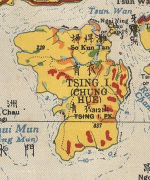
Tsing Yi Peak
Encyclopedia
Hong Kong
Hong Kong is one of two Special Administrative Regions of the People's Republic of China , the other being Macau. A city-state situated on China's south coast and enclosed by the Pearl River Delta and South China Sea, it is renowned for its expansive skyline and deep natural harbour...
. The hill is situated on the western half of Victoria Harbour
Victoria Harbour
Victoria Harbour is a natural landform harbour situated between Hong Kong Island and the Kowloon Peninsula in Hong Kong. The harbour's deep, sheltered waters and strategic location on the South China Sea were instrumental in Hong Kong's establishment as a British colony and its subsequent...
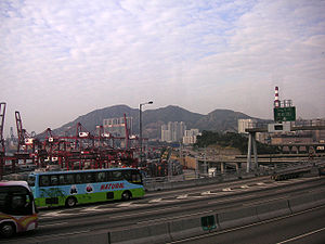
. Its peaks are good locations to observe the harbour and the channels among harbour islands. While situated in the south, a short hill Liu To Shan occupied the northwest of the island.
The three peaks align along north and south, and their heights increase from north to south. The highest south peak is of 334 metres. There is a paved trail
Trail
A trail is a path with a rough beaten or dirt/stone surface used for travel. Trails may be for use only by walkers and in some places are the main access route to remote settlements...
linking three peaks and the hill is a hot spot of easy hiking.
Two tunnels run beneath the hill. Cheung Tsing Tunnel
Cheung Tsing Tunnel
Cheung Tsing Tunnel, also spelt Cheung Ching Tunnel, is a dual tube 3-lane tunnel on Tsing Yi Island, Hong Kong. It is part of Tsing Kwai Highway of Route 3. Its east end connects to Rambler Channel Bridge and west Cheung Tsing Highway. The tunnel was opened on 1997-05-22 and is the second...
goes through the north peak while Nam Wan Tunnel
Nam Wan Tunnel
Nam Wan Tunnel is a tunnel in Hong Kong which has been completed and is scheduled for opening to traffic on 20 December 2009, along with the West Tsing Yi Viaduct, East Tsing Yi Viaduct and Stonecutters Bridge...
through the three peaks in diagonal. There is no vehicle access to the peaks.
Most of the petroleum oil depots in Hong Kong are located on the south and west industrial area of the Tsing Yi Island. Tsing Yi Peak is a natural barrier protecting 20 thousand residents in the island north and east.
Alternative indigenous name Sam Chi Heung (三支香) means three joss sticks associating with its shape of three peaks.
North peak
Burial Ground
Burial Ground is the ninth studio album by Swedish death metal band Grave, released in June 2010.-Track listing:# "Liberation" - 3:40# "Semblance In Black" - 7:50# "Dismembered Mind" - 6:10# "Ridden With Belief" - 7:57# "Conquerer" - 4:44...
for indigenous inhabitant
Indigenous inhabitant
Indigenous inhabitants refers to the residents in the New Territories of Hong Kong, whose ancestors were inhabitants there before the commencement of British rule in 1898 and have special rights to preserve their customs...
s of Tsing Yi Island. The burial ground occupies the north-east quardrant of the peak. A covered service reservoir with two football pitch
Association football pitch
An association football pitch is the playing surface for the game of association football made of turf. Its dimensions and markings are defined by Law 1 of the Laws of the Game, "The Field of Play".All line markings on the pitch form part of the area which they define...
es are also situated near the residential area, Cheung Ching Estate and Cheung Hong Estate. The paved trail starting near the Cheung Ching Bus Terminus made a way to the peak via football pitch and burial ground. Alternative paved trail to peak starts from Mayfair Gardens
Mayfair Gardens
Mayfair Gardens is the first private housing estate on Tsing Yi Island of Hong Kong by Sun Hung Kai Properties, and was established between 1982 and 1984. There are 8 blocks of residence buildings all round the estate, namely Block 5 to 12....
near a bus stop at Ching Hong Road
Ching Hong Road
Ching Hong Road is the third major road, connecting Tsing Yi Road and Tsing Yi Road West, built on Tsing Yi Island after the completion of Tsing Yi Bridge, the only road access across Rambler Channel at the time, in Hong Kong. The road, early part of the new town on the island, is the major...
.
On the north peak erects a pavilion
Pavilion (structure)
In architecture a pavilion has two main meanings.-Free-standing structure:Pavilion may refer to a free-standing structure sited a short distance from a main residence, whose architecture makes it an object of pleasure. Large or small, there is usually a connection with relaxation and pleasure in...
and a trigonometrical station. Most of the new town
New towns of Hong Kong
The area of Hong Kong is very mountainous and many places in the New Territories have limited access to roads. Hong Kong started developing new towns in the 1950s, to accommodate booming populations. In the early days the term "satellite towns" was used. The very first new towns included Tsuen Wan...
of Tsing Yi, Tsuen Wan and Kwai Chung, and the Rambler Channel
Rambler Channel
Rambler Channel is a body of water in Hong Kong that separates Tsing Yi Island from mainland Kowloon Peninsula, namely Tsuen Wan and Kwai Chung in the New Territories...
is under its north and east while Ma Wan Channel
Ma Wan Channel
Ma Wan Channel is a channel between Ma Wan and Tsing Yi Island in Hong Kong. The north end of the channel is Ting Kau where it joins the Rambler Channel. To the west it joins with the Kap Shui Mun channel running to the south of Ma Wan, leading into Urmston Road. To the east it divides into the...
, Tsing Ma Bridge
Tsing Ma Bridge
The Tsing Ma Bridge is a bridge in Hong Kong. It is the world's seventh-longest span suspension bridge, and was the second longest at time of completion. The bridge was named after two of the islands at its ends, namely Tsing Yi and Ma Wan . It has two decks and carries both road and rail...
, Liu To Shan and northeast Lantau Island
Lantau Island
Lantau Island , based on the old local name of Lantau Peak , is the largest island in Hong Kong, located at the mouth of the Pearl River. Administratively, most of Lantau Island is part of the Islands District of Hong Kong...
under its west.
The paved trail continues south to meet the middle peak.
Middle peak
The middle peak is more cone-shaped than the rest two. Great stones of various shapes gather at the highest points. An obstacle light was built by Civil Aviation DepartmentCivil Aviation Department (Hong Kong)
The Civil Aviation Department is the Civil aviation authority of Hong Kong, headquartered in the Queensway Government Offices . The department is responsible for providing air traffic control services to all aircraft operating within the Hong Kong Flight Information Region. It reports to the...
near the stones. Interestingly, the middle peak is assigned as Hill No. 6 on the signboard of the light.
The middle peak is reachable by the paved trail or a less obvious path from Hong Kong Institute of Vocational Education (Tsing Yi). This path with paved ladders goes uphill along the valley between the north and middle peak. Agricultural fields are found in mid-level by a stream
Stream
A stream is a body of water with a current, confined within a bed and stream banks. Depending on its locale or certain characteristics, a stream may be referred to as a branch, brook, beck, burn, creek, "crick", gill , kill, lick, rill, river, syke, bayou, rivulet, streamage, wash, run or...
. The path become less obvious afterward. The burial ground of Chan's family helps to identify the way up to the above-mentioned paved trail.
South peak
The south peak is the highest among three peaks. The top of the peak is relatively flat. A trigonometrical station is highest point on the Tsing Yi Island. Like the middle peak, an obstacle light was established to help aeroplanes avoiding the peaks at night. The peak is assigned as Hill No. 5 on its signboard.The southeast slope near the top was found the Hong Kong Croton
Hong Kong croton
Croton hancei, the Hong Kong croton, is a species of Croton which is endemic to Tsing Yi Island, Hong Kong. In Hong Kong, it is a protected species under the Forestry Regulations Cap. 96A....
and is now Site of Special Scientifc Interest
Site of Special Scientific Interest (Hong Kong)
Site of Special Scientific Interest or SSSI is a special area to protect wildlife, habitats and geographic features based on scientic interest in Hong Kong. Scientic interests are special features relating to animal life, plant life, geology and/or geography...
to protect the species.
The south peak is a good situation to observe the south end of the Tsing Yi Island, Rambler Channel
Rambler Channel
Rambler Channel is a body of water in Hong Kong that separates Tsing Yi Island from mainland Kowloon Peninsula, namely Tsuen Wan and Kwai Chung in the New Territories...
and Victoria Harbour
Victoria Harbour
Victoria Harbour is a natural landform harbour situated between Hong Kong Island and the Kowloon Peninsula in Hong Kong. The harbour's deep, sheltered waters and strategic location on the South China Sea were instrumental in Hong Kong's establishment as a British colony and its subsequent...
. In a clear day, its south is surrounded by waters hugged by Kowloon Peninsula
Kowloon Peninsula
The Kowloon Peninsula is a peninsula that forms the southern part of the main landmass in the territory of Hong Kong. The Kowloon Peninsula and the area of New Kowloon are collectively known as Kowloon....
, Stonecutters Island
Stonecutters Island
Stonecutters Island or Ngong Shuen Chau is a former island in Victoria Harbour, Hong Kong. Following land reclamation, it is now annexed to the Kowloon peninsula.-Fauna:...
, Hong Kong Island
Hong Kong Island
Hong Kong Island is an island in the southern part of the Hong Kong Special Administrative Region. It has a population of 1,289,500 and its population density is 16,390/km², as of 2008...
, Green Island
Green Island, Hong Kong
Green Island is an island off the northwest coast of Kennedy Town on the Hong Kong Island in Hong Kong, separated by the Sulphur Channel. A smaller island nearby to the east, uninhabited, is called Little Green Island...
, Kau Yi Chau
Kau Yi Chau
Kau Yi Chau , also known as Tai Kau Yi Chau , is an uninhabited island located west of Victoria Harbour, between Peng Chau and Green Island in Hong Kong. It is located on the crossroad of sea routes, east to west and north to south. The ferry between Central of Hong Kong Island and Mui Wo of...
, Peng Chau
Peng Chau
Peng Chau is a small island located off the north-eastern coast of Lantau Island, Hong Kong, which has an area of 0.99 km².Peng Chau is known for its small island lifestyle, accessibility to fresh seafood, and several temples located around the island...
, Lantau Island
Lantau Island
Lantau Island , based on the old local name of Lantau Peak , is the largest island in Hong Kong, located at the mouth of the Pearl River. Administratively, most of Lantau Island is part of the Islands District of Hong Kong...
, Tang Lung Chau
Tang Lung Chau
Tang Lung Chau is a small island to the west of Hong Kong Island, Hong Kong.This island is located off the south coast of Ma Wan, and is administratively part of Tsuen Wan District.-Lighthouse:...
and Ma Wan
Ma Wan
Ma Wan is an island of Hong Kong, located between Lantau Island and Tsing Yi Island, with an area of 0.97 km². Administratively, it is part of Tsuen Wan District....
. Nearly a hundred ships are staying on the water. The Container Terminal 9
Container Terminal 9
Container Terminal 9 or CT9 is the 9th container terminal in Hong Kong. It is located on Tsing Yi Island, facing Rambler Channel. It was the part of Kwai Tsing Container Terminals. The total site area is 1.5 square kilometres and the terminal itself comprises an area 0.68 km² and as long as...
of Kwai Tsing Container Terminals
Kwai Tsing Container Terminals
Kwai Tsing Container Terminals is the main port facilities in the reclamation along Rambler Channel between Kwai Chung and Tsing Yi Island, Hong Kong. It evolves from 4 berths of Kwai Chung Container Port completed in 1970s. It later expanded with two berths in 1980s...
is on its near shore and all others on another shore of Rambler Channel.
Apart from the paved trail leading from the middle peak, the south peak is also reachable from the direction of Ng Tsang Lau
Ng Tsang Lau
Ng Tsang Lau is a cape in the south west corner of Tsing Yi Island, Hong Kong. Its shore was reclaimed for the Mobil oil depot. It is near Tai Nam Wan on the island....
.