
.gif)
Tropical Storm Bertha (2002)
Encyclopedia
Tropical Storm Bertha was a minimal tropical storm
that made landfall twice along the Gulf Coast of the United States
in August 2002. The second tropical storm of the 2002 Atlantic hurricane season
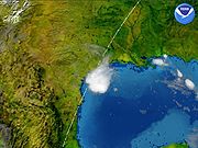
, Bertha developed in the northern Gulf of Mexico
out of a trough
of low pressure that extended into the Atlantic on August 4. It quickly organized and reached tropical storm strength before making landfall on southeastern Louisiana
. Bertha turned to the southwest over the state, and re-entered the Gulf of Mexico on August 7. It remained disorganized due to proximity to land, and after making landfall on south Texas
, Bertha dissipated on August 9.
Bertha was one of only three tropical cyclones to make landfall on both Louisiana
and Texas
; the others being Allison in 2001
and Fern in 1971. Heavy surf killed one person in Florida
. The storm dropped moderate amounts of rainfall along its path, peaking at over 10 inches (250 mm) in eastern Louisiana
and southern Mississippi
. Damage was light, totaling to only $200,000 (2002 USD, $240,000 2008 USD).
at the surface extended from the northern Gulf of Mexico
across Florida
into the western Atlantic Ocean
. On August 3, the western portion developed into a low pressure area
. The eastern portion slowly organized and ultimately developed into Tropical Storm Cristobal
. The low pressure area in the Gulf of Mexico steadily organized, and late on August 4 the circulation was organized enough for the National Hurricane Center
to classify it as Tropical Depression Two while located 40 miles (65 km) east of Port Eads, Louisiana
. Northeasterly wind shear
initially prevented organization of the cloud pattern, though the depression was able to strengthen to become Tropical Storm Bertha about five hours after it formed.
Outflow became much better organized as Bertha became a tropical storm, and well-defined banding features
persisted to the north of the storm. Though convection waned, forecasters predicted the friction between land and the warm atmosphere to redevelop more deep convection, potentially resulting in further strengthening. However, the storm failed to intensify, and Bertha made landfall near Boothville, Louisiana as a minimal tropical storm early on August 5. It slowly weakened over the swampy portions of southeastern Louisiana, and degenerated to a tropical depression later on the 5th after crossing Lake Ponchartrain. Initially it was expected that a ridge
of high pressure to its north would keep Bertha moving to the west and result in it slowly dissipating. However, it turned to the southwest, and reached the Gulf of Mexico again on August 7. The circulation persisted over land, and Tropical Depression Bertha quickly redeveloped convection. Though the environment was not unfavorable, its proximity to land prevented re-strengthening to tropical storm status. Though the system showed periods of increased organization as it moved southwestward, Bertha remained a weak tropical depression until making landfall on south Texas
to the east of Kingsville
on August 9. Bertha weakened quickly over land, and dissipated over southern Texas ten hours after making landfall.
issued a tropical storm warning
from Pascagoula, Mississippi
to the mouth of the Mississippi River
as Bertha became a tropical storm. The warning occurred 90 minutes before the storm made landfall. All warnings were discontinued when Bertha weakened to a tropical depression over Louisiana. No watches or warnings were required for Texas, due to the improbability of it re-intensifying.
The National Weather Service
advised boats along the Gulf coast to remain at port. The service also issued a coastal flood watch from Alabama through the Florida Panhandle
. A flood watch was issued for portions of eastern Louisiana and southwestern Mississippi.
coastline. In Perdido Key State Recreation Area
, two children were swimming in an unguarded area when they swept away by the currents. Their grandfather attempted to rescue them, but drowned in the rough waters. Another family rescued the two children. The large circulation of Bertha produced light rainfall across Florida, with Pensacola
and Destin
reporting 2.75 inches. Extreme southern portions of Alabama
received over 3 inches (75 mm) of rain from the storm, while western Dauphin Island reported over 5 inches (125 mm).
 Upon making landfall, Waveland, Mississippi
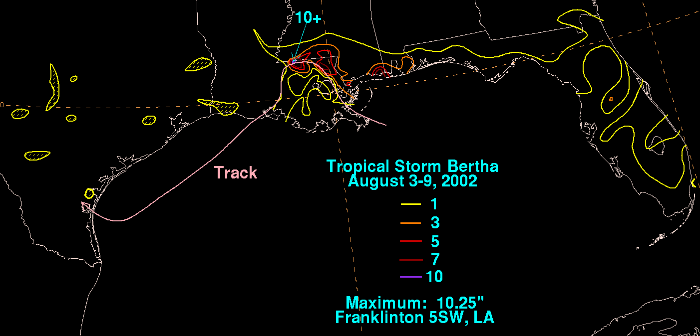
recorded a peak storm surge of 4.12 feet (1.26 m). Sustained winds there peaked at 31 mph (50 km/h), and a peak gust of 41 mph (66 km/h). Tropical Storm Bertha produced moderate to heavy precipitation across southern Mississippi, including a total of 10.25 inches (260.35 mm) in Pascagoula
. In Moss Point
, the rainfall resulted in flooding which entered 15 to 20 houses and several cars. The rainfall also flooded roadways and streets. Damage in Mississippi totaled to $50,000 (2002 USD, $60,000 2008 USD).
The storm dropped heavy rainfall in Louisiana
, which peaked at 10.25 inches in Norwood
. Storm tides were generally 1 to 2 feet (.3 to .6 m) above normal, while the mouth of the Bayou Dupre
recorded a storm tide of 3.79 feet (1.16 m). The rainfall led to flash flooding in places, and also a few overflowed rivers in St. Tammany Parish
. The flooding covered several roadways and bridges, and entered a few businesses and houses in East Feliciana Parish
. Damage in Louisiana totaled to $150,000 (2002 USD, $180,000 2008 USD).
In Texas
, Bertha produced a storm tide of 3 feet (.9 m) at Baffin Bay
. Only light rainfall occurred in the state, with a few isolated areas receiving over 1 inch (25 mm) of precipitation.
Tropical cyclone
A tropical cyclone is a storm system characterized by a large low-pressure center and numerous thunderstorms that produce strong winds and heavy rain. Tropical cyclones strengthen when water evaporated from the ocean is released as the saturated air rises, resulting in condensation of water vapor...
that made landfall twice along the Gulf Coast of the United States
Gulf Coast of the United States
The Gulf Coast of the United States, sometimes referred to as the Gulf South, South Coast, or 3rd Coast, comprises the coasts of American states that are on the Gulf of Mexico, which includes Texas, Louisiana, Mississippi, Alabama, and Florida and are known as the Gulf States...
in August 2002. The second tropical storm of the 2002 Atlantic hurricane season
2002 Atlantic hurricane season
The 2002 Atlantic hurricane season was an average Atlantic hurricane season, officially starting on June 1, 2002 and ending on November 30, dates which conventionally limit the period of each year when tropical cyclones in the Atlantic Ocean tend to form...
, Bertha developed in the northern Gulf of Mexico
Gulf of Mexico
The Gulf of Mexico is a partially landlocked ocean basin largely surrounded by the North American continent and the island of Cuba. It is bounded on the northeast, north and northwest by the Gulf Coast of the United States, on the southwest and south by Mexico, and on the southeast by Cuba. In...
out of a trough
Trough (meteorology)
A trough is an elongated region of relatively low atmospheric pressure, often associated with fronts.Unlike fronts, there is not a universal symbol for a trough on a weather chart. The weather charts in some countries or regions mark troughs by a line. In the United States, a trough may be marked...
of low pressure that extended into the Atlantic on August 4. It quickly organized and reached tropical storm strength before making landfall on southeastern Louisiana
Louisiana
Louisiana is a state located in the southern region of the United States of America. Its capital is Baton Rouge and largest city is New Orleans. Louisiana is the only state in the U.S. with political subdivisions termed parishes, which are local governments equivalent to counties...
. Bertha turned to the southwest over the state, and re-entered the Gulf of Mexico on August 7. It remained disorganized due to proximity to land, and after making landfall on south Texas
Texas
Texas is the second largest U.S. state by both area and population, and the largest state by area in the contiguous United States.The name, based on the Caddo word "Tejas" meaning "friends" or "allies", was applied by the Spanish to the Caddo themselves and to the region of their settlement in...
, Bertha dissipated on August 9.
Bertha was one of only three tropical cyclones to make landfall on both Louisiana
Louisiana
Louisiana is a state located in the southern region of the United States of America. Its capital is Baton Rouge and largest city is New Orleans. Louisiana is the only state in the U.S. with political subdivisions termed parishes, which are local governments equivalent to counties...
and Texas
Texas
Texas is the second largest U.S. state by both area and population, and the largest state by area in the contiguous United States.The name, based on the Caddo word "Tejas" meaning "friends" or "allies", was applied by the Spanish to the Caddo themselves and to the region of their settlement in...
; the others being Allison in 2001
Tropical Storm Allison
Tropical Storm Allison was a tropical storm that devastated southeast Texas in June of the 2001 Atlantic hurricane season. The first storm of the season, Allison lasted an unusually long period of time for a June storm, remaining tropical or subtropical for 15 days...
and Fern in 1971. Heavy surf killed one person in Florida
Florida
Florida is a state in the southeastern United States, located on the nation's Atlantic and Gulf coasts. It is bordered to the west by the Gulf of Mexico, to the north by Alabama and Georgia and to the east by the Atlantic Ocean. With a population of 18,801,310 as measured by the 2010 census, it...
. The storm dropped moderate amounts of rainfall along its path, peaking at over 10 inches (250 mm) in eastern Louisiana
Louisiana
Louisiana is a state located in the southern region of the United States of America. Its capital is Baton Rouge and largest city is New Orleans. Louisiana is the only state in the U.S. with political subdivisions termed parishes, which are local governments equivalent to counties...
and southern Mississippi
Mississippi
Mississippi is a U.S. state located in the Southern United States. Jackson is the state capital and largest city. The name of the state derives from the Mississippi River, which flows along its western boundary, whose name comes from the Ojibwe word misi-ziibi...
. Damage was light, totaling to only $200,000 (2002 USD, $240,000 2008 USD).
Meteorological history
A non-tropical troughTrough (meteorology)
A trough is an elongated region of relatively low atmospheric pressure, often associated with fronts.Unlike fronts, there is not a universal symbol for a trough on a weather chart. The weather charts in some countries or regions mark troughs by a line. In the United States, a trough may be marked...
at the surface extended from the northern Gulf of Mexico
Gulf of Mexico
The Gulf of Mexico is a partially landlocked ocean basin largely surrounded by the North American continent and the island of Cuba. It is bounded on the northeast, north and northwest by the Gulf Coast of the United States, on the southwest and south by Mexico, and on the southeast by Cuba. In...
across Florida
Florida
Florida is a state in the southeastern United States, located on the nation's Atlantic and Gulf coasts. It is bordered to the west by the Gulf of Mexico, to the north by Alabama and Georgia and to the east by the Atlantic Ocean. With a population of 18,801,310 as measured by the 2010 census, it...
into the western Atlantic Ocean
Atlantic Ocean
The Atlantic Ocean is the second-largest of the world's oceanic divisions. With a total area of about , it covers approximately 20% of the Earth's surface and about 26% of its water surface area...
. On August 3, the western portion developed into a low pressure area
Low pressure area
A low-pressure area, or "low", is a region where the atmospheric pressure at sea level is below that of surrounding locations. Low-pressure systems form under areas of wind divergence which occur in upper levels of the troposphere. The formation process of a low-pressure area is known as...
. The eastern portion slowly organized and ultimately developed into Tropical Storm Cristobal
Tropical Storm Cristobal (2002)
Tropical Storm Cristobal was a relatively weak tropical cyclone that meandered in the western Atlantic Ocean prior to being absorbed into a frontal zone. The third named storm of the 2002 Atlantic hurricane season, Cristobal developed on August 5 near the coast of South Carolina from the same...
. The low pressure area in the Gulf of Mexico steadily organized, and late on August 4 the circulation was organized enough for the National Hurricane Center
National Hurricane Center
The National Hurricane Center , located at Florida International University in Miami, Florida, is the division of the National Weather Service responsible for tracking and predicting weather systems within the tropics between the Prime Meridian and the 140th meridian west poleward to the 30th...
to classify it as Tropical Depression Two while located 40 miles (65 km) east of Port Eads, Louisiana
Port Eads, Louisiana
Port Eads, Louisiana, is located at the southern tip of the Mississippi River, also known as South Pass in Plaquemines Parish. It is the southern most point in Louisiana.-James Buchanan Eads:...
. Northeasterly wind shear
Wind shear
Wind shear, sometimes referred to as windshear or wind gradient, is a difference in wind speed and direction over a relatively short distance in the atmosphere...
initially prevented organization of the cloud pattern, though the depression was able to strengthen to become Tropical Storm Bertha about five hours after it formed.
Outflow became much better organized as Bertha became a tropical storm, and well-defined banding features
Rainband
A rainband is a cloud and precipitation structure associated with an area of rainfall which is significantly elongated. Rainbands can be stratiform or convective, and are generated by differences in temperature. When noted on weather radar imagery, this precipitation elongation is referred to as...
persisted to the north of the storm. Though convection waned, forecasters predicted the friction between land and the warm atmosphere to redevelop more deep convection, potentially resulting in further strengthening. However, the storm failed to intensify, and Bertha made landfall near Boothville, Louisiana as a minimal tropical storm early on August 5. It slowly weakened over the swampy portions of southeastern Louisiana, and degenerated to a tropical depression later on the 5th after crossing Lake Ponchartrain. Initially it was expected that a ridge
Ridge (meteorology)
A ridge is an elongated region of relatively high atmospheric pressure, the opposite of a trough....
of high pressure to its north would keep Bertha moving to the west and result in it slowly dissipating. However, it turned to the southwest, and reached the Gulf of Mexico again on August 7. The circulation persisted over land, and Tropical Depression Bertha quickly redeveloped convection. Though the environment was not unfavorable, its proximity to land prevented re-strengthening to tropical storm status. Though the system showed periods of increased organization as it moved southwestward, Bertha remained a weak tropical depression until making landfall on south Texas
Texas
Texas is the second largest U.S. state by both area and population, and the largest state by area in the contiguous United States.The name, based on the Caddo word "Tejas" meaning "friends" or "allies", was applied by the Spanish to the Caddo themselves and to the region of their settlement in...
to the east of Kingsville
Kingsville, Texas
As of the census of 2000, there were 25,575 people, 8,943 households, and 6,134 families residing in the city. The population density was 1,848.8 people per square mile . There were 10,427 housing units at an average density of 753.8 per square mile...
on August 9. Bertha weakened quickly over land, and dissipated over southern Texas ten hours after making landfall.
Preparations
The National Hurricane CenterNational Hurricane Center
The National Hurricane Center , located at Florida International University in Miami, Florida, is the division of the National Weather Service responsible for tracking and predicting weather systems within the tropics between the Prime Meridian and the 140th meridian west poleward to the 30th...
issued a tropical storm warning
Tropical cyclone warnings and watches
Warnings and watches are two levels of alert issued by national weather forecasting bodies to coastal areas threatened by the imminent approach of a tropical cyclone of tropical storm or hurricane intensity. They are notices to the local population and civil authorities to make appropriate...
from Pascagoula, Mississippi
Pascagoula, Mississippi
Pascagoula is a city in Jackson County, Mississippi, United States. It is the principal city of the Pascagoula, Mississippi Metropolitan Statistical Area, as a part of the Gulfport–Biloxi–Pascagoula, Mississippi Combined Statistical Area. The population was 26,200 at the 2000 census...
to the mouth of the Mississippi River
Mississippi River
The Mississippi River is the largest river system in North America. Flowing entirely in the United States, this river rises in western Minnesota and meanders slowly southwards for to the Mississippi River Delta at the Gulf of Mexico. With its many tributaries, the Mississippi's watershed drains...
as Bertha became a tropical storm. The warning occurred 90 minutes before the storm made landfall. All warnings were discontinued when Bertha weakened to a tropical depression over Louisiana. No watches or warnings were required for Texas, due to the improbability of it re-intensifying.
The National Weather Service
National Weather Service
The National Weather Service , once known as the Weather Bureau, is one of the six scientific agencies that make up the National Oceanic and Atmospheric Administration of the United States government...
advised boats along the Gulf coast to remain at port. The service also issued a coastal flood watch from Alabama through the Florida Panhandle
Florida Panhandle
The Florida Panhandle, an informal, unofficial term for the northwestern part of Florida, is a strip of land roughly 200 miles long and 50 to 100 miles wide , lying between Alabama on the north and the west, Georgia also on the north, and the Gulf of Mexico to the south. Its eastern boundary is...
. A flood watch was issued for portions of eastern Louisiana and southwestern Mississippi.
Impact
The area of low pressure preceding the development of Bertha produced rough surf and rip currents along the FloridaFlorida
Florida is a state in the southeastern United States, located on the nation's Atlantic and Gulf coasts. It is bordered to the west by the Gulf of Mexico, to the north by Alabama and Georgia and to the east by the Atlantic Ocean. With a population of 18,801,310 as measured by the 2010 census, it...
coastline. In Perdido Key State Recreation Area
Perdido Key State Recreation Area
Perdido Key State Park is a Florida State Park located on a barrier island fifteen miles southwest of Pensacola, off S.R. 292, in northwestern Florida. The address is 12301 Gulf Beach Highway.- Perdido Key State Park :...
, two children were swimming in an unguarded area when they swept away by the currents. Their grandfather attempted to rescue them, but drowned in the rough waters. Another family rescued the two children. The large circulation of Bertha produced light rainfall across Florida, with Pensacola
Pensacola, Florida
Pensacola is the westernmost city in the Florida Panhandle and the county seat of Escambia County, Florida, United States of America. As of the 2000 census, the city had a total population of 56,255 and as of 2009, the estimated population was 53,752...
and Destin
Destin, Florida
Destin is a city located in Okaloosa County, Florida. It is a principal city of the Fort Walton Beach-Crestview-Destin, Florida Metropolitan Statistical Area.Located on Florida's Emerald Coast, Destin is known for its white beaches and emerald green waters...
reporting 2.75 inches. Extreme southern portions of Alabama
Alabama
Alabama is a state located in the southeastern region of the United States. It is bordered by Tennessee to the north, Georgia to the east, Florida and the Gulf of Mexico to the south, and Mississippi to the west. Alabama ranks 30th in total land area and ranks second in the size of its inland...
received over 3 inches (75 mm) of rain from the storm, while western Dauphin Island reported over 5 inches (125 mm).
Waveland, Mississippi
Waveland is a city located in Hancock County, Mississippi, on the Gulf of Mexico. It is part of the Gulfport–Biloxi, Mississippi Metropolitan Statistical Area. The City of Waveland was incorporated in 1972. As of the 2000 census, the city had a total population of 6,674...
recorded a peak storm surge of 4.12 feet (1.26 m). Sustained winds there peaked at 31 mph (50 km/h), and a peak gust of 41 mph (66 km/h). Tropical Storm Bertha produced moderate to heavy precipitation across southern Mississippi, including a total of 10.25 inches (260.35 mm) in Pascagoula
Pascagoula, Mississippi
Pascagoula is a city in Jackson County, Mississippi, United States. It is the principal city of the Pascagoula, Mississippi Metropolitan Statistical Area, as a part of the Gulfport–Biloxi–Pascagoula, Mississippi Combined Statistical Area. The population was 26,200 at the 2000 census...
. In Moss Point
Moss Point, Mississippi
Moss Point is a city, north of Pascagoula, in Jackson County, Mississippi, United States. The population was 17,653 at the 2000 census.On August 29, 2005, Moss Point was hit by the strong east side of Hurricane Katrina, and much of Moss Point was flooded or destroyed .-Geography:Moss Point is...
, the rainfall resulted in flooding which entered 15 to 20 houses and several cars. The rainfall also flooded roadways and streets. Damage in Mississippi totaled to $50,000 (2002 USD, $60,000 2008 USD).
The storm dropped heavy rainfall in Louisiana
Louisiana
Louisiana is a state located in the southern region of the United States of America. Its capital is Baton Rouge and largest city is New Orleans. Louisiana is the only state in the U.S. with political subdivisions termed parishes, which are local governments equivalent to counties...
, which peaked at 10.25 inches in Norwood
Norwood, Louisiana
Norwood is a village in East Feliciana Parish, Louisiana, United States. The population was 337 at the 2000 census. It is part of the Baton Rouge Metropolitan Statistical Area.-Geography:...
. Storm tides were generally 1 to 2 feet (.3 to .6 m) above normal, while the mouth of the Bayou Dupre
Bayou Dupre
Bayou Dupre is a bayou in southeastern Louisiana....
recorded a storm tide of 3.79 feet (1.16 m). The rainfall led to flash flooding in places, and also a few overflowed rivers in St. Tammany Parish
St. Tammany Parish, Louisiana
St. Tammany Parish is a parish located in the U.S. state of Louisiana, in the New Orleans–Metairie–Kenner Metropolitan Statistical Area. The parish seat is Covington....
. The flooding covered several roadways and bridges, and entered a few businesses and houses in East Feliciana Parish
East Feliciana Parish, Louisiana
East Feliciana Parish is a parish located in the U.S. state of Louisiana. The parish seat is Clinton. In 2000, the population was 21,360.East Feliciana Parish is part of the Baton Rouge Metropolitan Statistical Area as well as the Baton Rouge–Pierre Part Combined Statistical...
. Damage in Louisiana totaled to $150,000 (2002 USD, $180,000 2008 USD).
In Texas
Texas
Texas is the second largest U.S. state by both area and population, and the largest state by area in the contiguous United States.The name, based on the Caddo word "Tejas" meaning "friends" or "allies", was applied by the Spanish to the Caddo themselves and to the region of their settlement in...
, Bertha produced a storm tide of 3 feet (.9 m) at Baffin Bay
Baffin Bay, Texas
Baffin Bay is a bay in South Texas, an inlet of the larger Laguna Madre. Located near the Gulf of Mexico, Baffin Bay forms part of the boundary between Kenedy County and Kleberg County.-Etymology:The history of the bay name is unclear...
. Only light rainfall occurred in the state, with a few isolated areas receiving over 1 inch (25 mm) of precipitation.
See also
- Other storms of the same nameHurricane Bertha (disambiguation)The name Bertha has been used for six tropical cyclones in the Atlantic Ocean.* 1957's Tropical Storm Bertha: A moderate Tropical Storm that threatened areas devastated by Hurricane Audrey two months earlier, but did not become a hurricane and caused only minor damage.* 1984's Tropical Storm...
- List of Florida hurricanes (2000–present)