
Transportation in Edmonton
Encyclopedia
The city of Edmonton
, Alberta
, has a transportation network fairly typical for a Canadian city of its size, involving most modes of transport including, but certainly not limited to, air, rail, road and public transit.
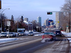
With very few natural barriers to growth and largely flat to gently rolling terrain bisected by a deep river valley, the city of Edmonton has expanded to cover an area of nearly 684 km2, of which only two-thirds is built-up. The metropolitan area covers over 9,418 km2. This has resulted in a heavily private transportation-oriented transportation network typical of any other city of its size in North America. However, Edmonton does not have the extensive limited access freeway system typical of what one would find in a US metro area, and the road network is somewhat unusual in regard to access to downtown.
 The Edmonton Transit System (ETS) is the primary public transportation agency, covering most parts of the city, but only within the City of Edmonton proper (with one exception). Neighbouring communities outside Edmonton's city limits such as Sherwood Park
and St. Albert
operate their own public transit agencies and offer public transportation to and from neighbouring communities. The smaller city of Fort Saskatchewan contracts out bus services there to ETS.
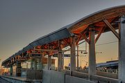
 In 1978, Edmonton was the first city with a population of under one million to operate a light rail
transit (LRT) system in North America. The LRT currently runs on a single line extending 20.5 km from Clareview Station in northeast Edmonton, across the North Saskatchewan River, to the Century Park neighbourhood. 7.6 km of the track is an underground line running through the downtown core and the University of Alberta main campus, with the rest at ground level.
A four year south extension of the LRT line was opened in full in April 2010.
Edmonton is also considering constructing an urban low floor tram
, compared to the current high floor trains, which would swivel through neighbourhoods easier.
) that operated a trolley bus
system until service was discontinued in May 2009. The ETS also operates a specialized system for disabled people called DATS (Disabled Adult Transit System).
Commuter service to Edmonton's suburbs is provided by Strathcona County Transit
and St. Albert Transit
.
and Saskatchewan
via the Yellowhead Highway
(Highway 16, or Yellowhead Trail within city limits), and to Calgary and Red Deer
via the Queen Elizabeth II Highway (known as Calgary Trail (southbound) or Gateway Boulevard (northbound) within city limits, on the alignment of the former Calgary and Edmonton Trail
).
 Edmonton's streets were originally all named streets and arranged so that avenues ran north-south and streets ran east-west. The first move to a grid-style system began as the city expanded west - the streets west of Queens Avenue were switched to run on a north-south orientation with 1st Street (now 101 Street) being west of Queens Avenue, and the street numbers increasing further west (i.e. 10 Street was one block west of 9 Street). West of Queens Avenue, the avenues also switched (running in an east-west direction); although, unlike the streets, the avenues were never numbered. This led to a confusing situation with avenues becoming streets despite no change in direction. For example, MacKenzie Avenue (now 104 Ave) became Boyle Street west of Queens Avenue, and Athabasca Avenue (now 102 Ave) became Elizabeth Street west of Queens Avenue.
The city of Strathcona
had adopted a grid and quandrant system before its amalgamation with Edmonton, with the city being centred on Main Street (now 104 Street) and Whyte Avenue (also named 82 Avenue). This street system was similar to that of present-day Calgary
's system, having NW, NE, SW and SE quandrants. Strathcona's grid/quandrant system was abandoned in 1914.
In 1914, following amalgamation with Strathcona, Edmonton adopted a new street numbering system, which with a few small modifications is still in use. The centre of the city, Jasper Avenue and 101 Street, was set as the starting point. Jasper Avenue was one of the few streets that was not given a number, likely because east of Namao Avenue (now 97 Street) Jasper Avenue switches direction and runs diagonally and parallel to the North Saskatchewan River
Valley, rather than east-west. The other avenues were numbered as if Jasper Avenue (between 124 Street and 97 Street) had been 101 Avenue. Several other streets have maintained their names in spite of having been reassigned as numbers — these include but are not limited to Whyte (82) Avenue
, Norwood Boulevard (111 Ave), and Alberta (118) Avenue, while others were given new names over time, such as Rue Hull (99) Street - which is a segment of what used to be Queens Avenue.
 Avenues run east and west; streets run north and south. Avenue numbers increase to the north; street numbers increase to the west. When a street lies between two numbered streets, letters are used, for example, 107A Avenue lies between 107 Avenue and 108 Avenue. Occasionally the letter B will be used and more rarely C, to denote multiple streets between 2 different street numbers. For example, 17A, 17B and 17C Avenues all lie between 17 Avenue and 18 Avenue.
Houses with odd numbers are on the east side of a street or the south side of an avenue. Dropping the last two digits of a house number tells you what two streets or avenues the house lies between, for example 8023 135A Avenue is between 80 Street and 81 Street, and 13602 100 Street is between 136 Avenue and 137 Avenue.
As the city grew in the 1980s, it began to run out of street numbers in the east, and avenue numbers in the south. Therefore, in 1982 a quadrant system was adopted. Quadrant Avenue (1 Avenue; only constructed west of the river) and Meridian Street (1 Street) divide the city into three quadrants: northwest (NW), southwest (SW), and northeast (NE). The vast majority of the city falls within the northwest quadrant.
All Edmonton streets now officially have their quadrant included at the end of their names, but it is usual — even on official signage — to omit the "NW" especially when there is no possibility of confusion with a street in another quadrant. The city's emergency services, however, have begun to encourage residents to get into the habit of using quadrants in all addresses.
is located south of the city limits, near the city of Leduc
. It is the fifth busiest airport in Canada, with over 6.0 million passengers using the facilities in 2009. Edmonton has scheduled daily non-stop service to all major Canadian cities, most major US hubs, and London Heathrow. Seasonal destinations include various Mexican and Caribbean resorts as well as Hawaii.
The smaller and older Edmonton City Centre Airport
— the oldest city-owned airport in Canada — is located just north of downtown Edmonton. Air passenger service from Edmonton City Centre Airport was consolidated to the International Airport in 1996. The older airport is currently used primarily for charter planes and flight training, although small non-chartered planes with fewer than 19 passengers are still allowed to land at the facility.
Edmonton Airports
controls Edmonton International, Edmonton City Centre and also Cooking Lake Airport
and Villeneuve Airport
, both of which primarily service general aviation
and flight training
services.
Edmonton is located geographically closer to many destinations in Europe and Asia than the airports in Calgary, Vancouver, Winnipeg as well as points in Western United States. Edmonton International Airport is the future home of Port Alberta
. The port is designed to provide a comprehensive shipping hub connection rail, air, and naval cargo shipments through the Port of Prince Rupert.
 Edmonton railway station
is served by Via Rail
trains on their transcontinental service The Canadian
. Westbound trains of The Canadian continue toward Jasper, Alberta
, while eastbound trains run toward Saskatoon, Saskatchewan. The station is located near the City Centre Airport. Formerly, the Via trains arrived at the CN office tower downtown, in the Old Canadian National rail yard
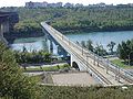
, but the downtown trackage has been abandoned to the LRT and new urban development
. The High Level Bridge
, formerly CPR's route into the downtown, is used in the summer for historical streetcars
.
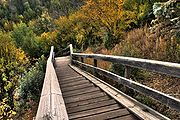 Edmonton has an extensive multi-use trail system totaling over 150 kilometres in length, 130 of which lie within the North Saskatchewan River valley parks system
. The unpaved trail network is even more extensive — 420 kilometres in total. The city also has 105 km of signed street bike paths across the city with protected crossings.
Edmonton has an indoor pedway system
connecting the Edmonton City Centre
mall, the Stanley A. Milner Library, the LRT system and other commercial office buildings in its downtown core. The pedway system runs above ground, at-grade as well as underground.
Edmonton
Edmonton is the capital of the Canadian province of Alberta and is the province's second-largest city. Edmonton is located on the North Saskatchewan River and is the centre of the Edmonton Capital Region, which is surrounded by the central region of the province.The city and its census...
, Alberta
Alberta
Alberta is a province of Canada. It had an estimated population of 3.7 million in 2010 making it the most populous of Canada's three prairie provinces...
, has a transportation network fairly typical for a Canadian city of its size, involving most modes of transport including, but certainly not limited to, air, rail, road and public transit.
With very few natural barriers to growth and largely flat to gently rolling terrain bisected by a deep river valley, the city of Edmonton has expanded to cover an area of nearly 684 km2, of which only two-thirds is built-up. The metropolitan area covers over 9,418 km2. This has resulted in a heavily private transportation-oriented transportation network typical of any other city of its size in North America. However, Edmonton does not have the extensive limited access freeway system typical of what one would find in a US metro area, and the road network is somewhat unusual in regard to access to downtown.
Public transportation
Sherwood Park, Alberta
Sherwood Park is a large hamlet in Alberta, Canada within Strathcona County that is recognized as an urban service area. It is located adjacent to the City of Edmonton's eastern boundary, generally south of Highway 16 , west of Highway 21 and north of Highway 630...
and St. Albert
St. Albert, Alberta
St. Albert is a suburban city in Alberta, located northwest of Edmonton, on the Sturgeon River. It was originally settled as a Métis community, and is now the second largest city in the Edmonton area. St...
operate their own public transit agencies and offer public transportation to and from neighbouring communities. The smaller city of Fort Saskatchewan contracts out bus services there to ETS.
Light rail
Light rail
Light rail or light rail transit is a form of urban rail public transportation that generally has a lower capacity and lower speed than heavy rail and metro systems, but higher capacity and higher speed than traditional street-running tram systems...
transit (LRT) system in North America. The LRT currently runs on a single line extending 20.5 km from Clareview Station in northeast Edmonton, across the North Saskatchewan River, to the Century Park neighbourhood. 7.6 km of the track is an underground line running through the downtown core and the University of Alberta main campus, with the rest at ground level.
A four year south extension of the LRT line was opened in full in April 2010.
Edmonton is also considering constructing an urban low floor tram
Tram
A tram is a passenger rail vehicle which runs on tracks along public urban streets and also sometimes on separate rights of way. It may also run between cities and/or towns , and/or partially grade separated even in the cities...
, compared to the current high floor trains, which would swivel through neighbourhoods easier.
Buses
The ETS operates a fleet of well over 800 buses across the city with 170 routes. Edmonton was one of two cities in Canada (the other is VancouverVancouver
Vancouver is a coastal seaport city on the mainland of British Columbia, Canada. It is the hub of Greater Vancouver, which, with over 2.3 million residents, is the third most populous metropolitan area in the country,...
) that operated a trolley bus
Trolleybus
A trolleybus is an electric bus that draws its electricity from overhead wires using spring-loaded trolley poles. Two wires and poles are required to complete the electrical circuit...
system until service was discontinued in May 2009. The ETS also operates a specialized system for disabled people called DATS (Disabled Adult Transit System).
Commuter service to Edmonton's suburbs is provided by Strathcona County Transit
Strathcona County Transit
Strathcona County Transit provides local, commuter and school bus services to the community of Sherwood Park, Alberta, Canada, which is situated just east of Edmonton in Strathcona County....
and St. Albert Transit
St. Albert Transit
St. Albert Transit is the public transportation system in the City of St. Albert, Alberta, Canada, which is located only about northwest of downtown Edmonton. Scheduled bus service consists of local circuits within the community and express commuter routes to Edmonton...
.
Highways
Edmonton is connected to British ColumbiaBritish Columbia
British Columbia is the westernmost of Canada's provinces and is known for its natural beauty, as reflected in its Latin motto, Splendor sine occasu . Its name was chosen by Queen Victoria in 1858...
and Saskatchewan
Saskatchewan
Saskatchewan is a prairie province in Canada, which has an area of . Saskatchewan is bordered on the west by Alberta, on the north by the Northwest Territories, on the east by Manitoba, and on the south by the U.S. states of Montana and North Dakota....
via the Yellowhead Highway
Yellowhead Highway
The Yellowhead Highway is a major east-west highway connecting the four western Canadian provinces of British Columbia, Alberta, Saskatchewan, and Manitoba. Although part of the Trans-Canada Highway system, the highway should not be confused with the more southerly, originally-designated...
(Highway 16, or Yellowhead Trail within city limits), and to Calgary and Red Deer
Red Deer, Alberta
Red Deer is a city in Central Alberta, Canada. It is located near the midpoint of the Calgary-Edmonton Corridor and is surrounded by Red Deer County. It is Alberta's third-most-populous city – after Calgary and Edmonton. The city is located in aspen parkland, a region of rolling hills...
via the Queen Elizabeth II Highway (known as Calgary Trail (southbound) or Gateway Boulevard (northbound) within city limits, on the alignment of the former Calgary and Edmonton Trail
Calgary and Edmonton Trail
The Calgary and Edmonton Trail was a land transport route between Fort Edmonton and Fort Calgary in the Canadian Northwest.Several trails south from the fur trade post at Fort Edmonton had existed for some time...
).
Arterial roads
Anthony Henday Drive (Highway 216) is a ring road transportation project which will eventually encircle the Edmonton Metropolitan area. The south west section from Highway 16 to Calgary Trail is open. The south east section from Calgary Trail / Gateway Boulevard to Highway 14 was completed and opened on October 23, 2007. The south east section is also now connected to the already-existing stretch of Highway 216 on the east side of the city between Highway 16 and approximately 23 Avenue. The first stage of the northwest portion is already completed from the Yellowhead Highway to the St. Albert west bypass in 2007. As of November 9, 2005, the Alberta Government has committed to finishing the north portion by 2011.Street layout
The city of Strathcona
Old Strathcona
Old Strathcona is an historic district located in south-central Edmonton, Alberta, Canada. Once the commercial core of the separate city of Strathcona, the area is now Edmonton's main arts and entertainment district, and in 2007 was named Alberta's second "Provincial Historic Area"...
had adopted a grid and quandrant system before its amalgamation with Edmonton, with the city being centred on Main Street (now 104 Street) and Whyte Avenue (also named 82 Avenue). This street system was similar to that of present-day Calgary
Calgary
Calgary is a city in the Province of Alberta, Canada. It is located in the south of the province, in an area of foothills and prairie, approximately east of the front ranges of the Canadian Rockies...
's system, having NW, NE, SW and SE quandrants. Strathcona's grid/quandrant system was abandoned in 1914.
In 1914, following amalgamation with Strathcona, Edmonton adopted a new street numbering system, which with a few small modifications is still in use. The centre of the city, Jasper Avenue and 101 Street, was set as the starting point. Jasper Avenue was one of the few streets that was not given a number, likely because east of Namao Avenue (now 97 Street) Jasper Avenue switches direction and runs diagonally and parallel to the North Saskatchewan River
North Saskatchewan River
The North Saskatchewan River is a glacier-fed river that flows east from the Canadian Rockies to central Saskatchewan. It is one of two major rivers that join to make up the Saskatchewan River....
Valley, rather than east-west. The other avenues were numbered as if Jasper Avenue (between 124 Street and 97 Street) had been 101 Avenue. Several other streets have maintained their names in spite of having been reassigned as numbers — these include but are not limited to Whyte (82) Avenue
Old Strathcona
Old Strathcona is an historic district located in south-central Edmonton, Alberta, Canada. Once the commercial core of the separate city of Strathcona, the area is now Edmonton's main arts and entertainment district, and in 2007 was named Alberta's second "Provincial Historic Area"...
, Norwood Boulevard (111 Ave), and Alberta (118) Avenue, while others were given new names over time, such as Rue Hull (99) Street - which is a segment of what used to be Queens Avenue.
Houses with odd numbers are on the east side of a street or the south side of an avenue. Dropping the last two digits of a house number tells you what two streets or avenues the house lies between, for example 8023 135A Avenue is between 80 Street and 81 Street, and 13602 100 Street is between 136 Avenue and 137 Avenue.
As the city grew in the 1980s, it began to run out of street numbers in the east, and avenue numbers in the south. Therefore, in 1982 a quadrant system was adopted. Quadrant Avenue (1 Avenue; only constructed west of the river) and Meridian Street (1 Street) divide the city into three quadrants: northwest (NW), southwest (SW), and northeast (NE). The vast majority of the city falls within the northwest quadrant.
All Edmonton streets now officially have their quadrant included at the end of their names, but it is usual — even on official signage — to omit the "NW" especially when there is no possibility of confusion with a street in another quadrant. The city's emergency services, however, have begun to encourage residents to get into the habit of using quadrants in all addresses.
Air
Edmonton is served by two major and several smaller general aviation airports. The largest airport, Edmonton International AirportEdmonton International Airport
Edmonton International Airport is the primary air passenger and air cargo facility in the Edmonton region in the Canadian province of Alberta. It is a hub facility for Northern Alberta and Northern Canada providing regularly scheduled nonstop flights to over fifty communities in Canada, the United...
is located south of the city limits, near the city of Leduc
Leduc, Alberta
- Demographics :The population of the City of Leduc according to its 2011 municipal census is 24,139, a 3.6% increase over its 2010 municipal census population of 23,293....
. It is the fifth busiest airport in Canada, with over 6.0 million passengers using the facilities in 2009. Edmonton has scheduled daily non-stop service to all major Canadian cities, most major US hubs, and London Heathrow. Seasonal destinations include various Mexican and Caribbean resorts as well as Hawaii.
The smaller and older Edmonton City Centre Airport
Edmonton City Centre (Blatchford Field) Airport
Edmonton City Centre Airport, , is located within the city of Edmonton, Alberta, Canada. It is bordered by Yellowhead Trail to the north, Kingsway to the south, 121 Street to the west, and the Northern Alberta Institute of Technology to the east. It encompasses approximately of land just north...
— the oldest city-owned airport in Canada — is located just north of downtown Edmonton. Air passenger service from Edmonton City Centre Airport was consolidated to the International Airport in 1996. The older airport is currently used primarily for charter planes and flight training, although small non-chartered planes with fewer than 19 passengers are still allowed to land at the facility.
Edmonton Airports
Edmonton Airports
Edmonton Airports, officially the Edmonton Regional Airports Authority, was formed in 1990, under the Regional Airports Authorities Act passed by the Legislative Assembly of Alberta in 1989, and is responsible for the management and operation of four airports in the Edmonton area...
controls Edmonton International, Edmonton City Centre and also Cooking Lake Airport
Edmonton/Cooking Lake Airport
Edmonton/Cooking Lake Airport, , is a registered aerodrome located next to Cooking Lake, north of South Cooking Lake, Alberta, Canada.-External links:** on COPA's Places to Fly airport directory...
and Villeneuve Airport
Edmonton/Villeneuve Airport
Edmonton/Villeneuve Airport or Villeneuve Airport, , is located west of Villeneuve in Sturgeon County, Alberta, Canada.-External links:* page at Edmonton Airports website* on COPA's Places to Fly airport directory...
, both of which primarily service general aviation
General aviation
General aviation is one of the two categories of civil aviation. It refers to all flights other than military and scheduled airline and regular cargo flights, both private and commercial. General aviation flights range from gliders and powered parachutes to large, non-scheduled cargo jet flights...
and flight training
Flight training
Flight training is a course of study used when learning to pilot an aircraft. The overall purpose of primary and intermediate flight training is the acquisition and honing of basic airmanship skills....
services.
Edmonton is located geographically closer to many destinations in Europe and Asia than the airports in Calgary, Vancouver, Winnipeg as well as points in Western United States. Edmonton International Airport is the future home of Port Alberta
Port Alberta
Port Alberta is a project by Edmonton International Airport in Edmonton, Alberta, Canada, to combine air, rail, and road transportation infrastructure at a single point, with future connections to the Port of Prince Rupert and the Port of Vancouver....
. The port is designed to provide a comprehensive shipping hub connection rail, air, and naval cargo shipments through the Port of Prince Rupert.
Inter-city rail
Edmonton (Via Rail station)
The Edmonton railway station is on the Canadian National Railway mainline in Edmonton, Alberta. The station is served by Via Rail's The Canadian three times per week in each direction. The train station is located near the Edmonton City Centre Airport, approximately 8–10 km from the city...
is served by Via Rail
VIA Rail
Via Rail Canada is an independent crown corporation offering intercity passenger rail services in Canada. It is headquartered near Montreal Central Station at 3 Place Ville-Marie in Montreal, Quebec....
trains on their transcontinental service The Canadian
The Canadian
The Canadian is a Canadian transcontinental passenger train originally operated by the Canadian Pacific Railway between 1955 and 1978. It is currently operated as an Inter-city rail service by Via Rail Canada with service between Union Station in Toronto, Ontario and Pacific Central Station in...
. Westbound trains of The Canadian continue toward Jasper, Alberta
Jasper, Alberta
Jasper is a specialized municipality in western Alberta, Canada. It is the commercial centre of Jasper National Park, located in the Canadian Rockies in the Athabasca River valley....
, while eastbound trains run toward Saskatoon, Saskatchewan. The station is located near the City Centre Airport. Formerly, the Via trains arrived at the CN office tower downtown, in the Old Canadian National rail yard
Old Canadian National rail yard
The old Canadian National rail yard in Edmonton was once the centre of economic activity in that city. Its redevelopment has fundamentally altered the appearance of the city...
, but the downtown trackage has been abandoned to the LRT and new urban development
Station Lands (Edmonton)
Station Lands will be a multi-use development in Edmonton, Alberta, Canada. It is being built in a 9.15-acre site north of CN Tower once occupied by the old Canadian National rail yard in the downtown of the city. Expected to be completed in 2019 to 2022, it will include four high-rise towers, a...
. The High Level Bridge
High Level Bridge (Edmonton)
The High Level Bridge, opened in 1913, spans the North Saskatchewan River in Edmonton, Alberta, Canada. Located next to the Alberta Legislature Building, the bridge linked the separate communities of Edmonton and Strathcona, which became one city in 1912. It was designed from the outset to...
, formerly CPR's route into the downtown, is used in the summer for historical streetcars
High Level Bridge Streetcar
The High Level Bridge Streetcar is a historic streetcar ride over the High Level Bridge in Edmonton, Alberta. It travels from the Strathcona Streetcar Barn & Museum, just north of the Strathcona Farmers Market, in Old Strathcona, to Jasper Plaza south of Jasper Avenue, between 109 Street and 110...
.
Bicycle and pedestrian
North Saskatchewan River valley parks system
The North Saskatchewan River valley parks system is a continuous collection of urban parks in the North Saskatchewan River valley of Edmonton, Alberta....
. The unpaved trail network is even more extensive — 420 kilometres in total. The city also has 105 km of signed street bike paths across the city with protected crossings.
Edmonton has an indoor pedway system
Edmonton Pedway
The Edmonton Pedway system is a network connecting office buildings, shopping centres, and parkades in downtown Edmonton, Alberta, Canada. It consists of approximately of year-round climate-controlled underground tunnels and walkways between the second floors of buildings approximately above...
connecting the Edmonton City Centre
Edmonton City Centre
Edmonton City Centre is a shopping mall in downtown Edmonton, Alberta, Canada, across the street from Churchill Square.-History:In 1974, the City Centre Place shopping mall was completed within the larger Edmonton Centre development; TD Tower was added in 1976. In 1978, Oxford Tower and the...
mall, the Stanley A. Milner Library, the LRT system and other commercial office buildings in its downtown core. The pedway system runs above ground, at-grade as well as underground.