
Ting Kau Bridge
Encyclopedia
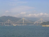
Ting Kau Bridge is a 1,177-metre
long cable-stayed bridge
in Hong Kong
that spans from the northwest of Tsing Yi Island and Tuen Mun Road
. It is adjacent to Tsing Ma Bridge
which also serves as major connector between the Hong Kong International Airport
on Lantau Island
and the rest of Hong Kong. It was completed in 1998. The bridge is toll-free.
The bridge is part of Route 3
, connecting North-west New Territories
with Hong Kong Island
. Other major infrastructures on the road includes Tai Lam Tunnel
, Cheung Tsing Tunnel
, Cheung Tsing Bridge and Western Harbour Crossing
. Compared to the nearby bridges on Lantau Link
, Ting Kau Bridge is not just a landmark structure but also carries the heaviest traffic volume of the bridges, with many container trucks travelling to and from mainland China and the HK container port. A chromatic study and specially designed architectural lighting
are intended to set the bridge off in its surroundings.
Ting Kau Bridge is the world's first major 4-span cable-stayed bridge. This meant that the central tower had to be stabilised longitudinally, the problem being solved using the longest (465 m) cable stays ever used in a bridge. The design of this bridge contains special features such as single leg towers, which are stabilised by transverse cables just like masts of a sailboat
. The Ting Kau Bridge and approach viaducts link the western New Territories and the mainland to an expressway called Lantau Fixed Crossing, which connects the new Airport with Kowloon
and Hong Kong
. It meets the Lantau Fixed Crossing on Tsing Yi Island only 500 m from the Tsing Ma Bridge.
The Ting Kau Bridge and Approach Viaduct are 1,875 metres long while the triple tower bridge has an overall length of 1,177 metres. Three towers have been specially designed to withstand extreme wind
and typhoon conditions, with heights of 170 metres, 194 metres, and 158 metres, located on the Ting Kau headland, on a reclaimed island
in Rambler Channel
(which spans 900 metres wide) and on the north-west Tsing Yi shoreline respectively.
The arrangement of separate decks on both sides of the 3 towers contributes to the slender appearance of the bridge while acting favourably under heavy wind and typhoon loads. Each deck carries 3 traffic lanes and a hard shoulder.
At a design & construction cost of HK$1.94 billion, it is one of the longest cable-stayed bridges in the world. Along with the Tsing Ma and Kap Shui Mun bridges, it is closely monitored by the Wind and Structural Health Monitoring System (WASHMS).
Ting Kau Contractors Joint Venture designed and built Ting Kau Bridge between 1994 and 1998. The joint venture comprised lead partners Cubiertas Y Mzov (22%) and Entrecanales Y Tavora (22%), both of Spain (now both part of Acciona, S.A
); Germany's Ed. Züblin
(22%); Australia's Downer and Co (22%); and Hong Kong's Paul Y (12%). Constructing engineers were Schlaich Bergermann & Partner
.
Metre
The metre , symbol m, is the base unit of length in the International System of Units . Originally intended to be one ten-millionth of the distance from the Earth's equator to the North Pole , its definition has been periodically refined to reflect growing knowledge of metrology...
long cable-stayed bridge
Cable-stayed bridge
A cable-stayed bridge is a bridge that consists of one or more columns , with cables supporting the bridge deck....
in Hong Kong
Hong Kong
Hong Kong is one of two Special Administrative Regions of the People's Republic of China , the other being Macau. A city-state situated on China's south coast and enclosed by the Pearl River Delta and South China Sea, it is renowned for its expansive skyline and deep natural harbour...
that spans from the northwest of Tsing Yi Island and Tuen Mun Road
Tuen Mun Road
Tuen Mun Road is a major expressway in Hong Kong which connects Tuen Mun in the New Territories with Tsuen Wan. It is part of Hong Kong's Route 9, which circumnavigates the New Territories...
. It is adjacent to Tsing Ma Bridge
Tsing Ma Bridge
The Tsing Ma Bridge is a bridge in Hong Kong. It is the world's seventh-longest span suspension bridge, and was the second longest at time of completion. The bridge was named after two of the islands at its ends, namely Tsing Yi and Ma Wan . It has two decks and carries both road and rail...
which also serves as major connector between the Hong Kong International Airport
Hong Kong International Airport
Hong Kong International Airport is the main airport in Hong Kong. It is colloquially known as Chek Lap Kok Airport , being built on the island of Chek Lap Kok by land reclamation, and also to distinguish it from its predecessor, the closed Kai Tak Airport.The airport opened for commercial...
on Lantau Island
Lantau Island
Lantau Island , based on the old local name of Lantau Peak , is the largest island in Hong Kong, located at the mouth of the Pearl River. Administratively, most of Lantau Island is part of the Islands District of Hong Kong...
and the rest of Hong Kong. It was completed in 1998. The bridge is toll-free.
The bridge is part of Route 3
Route 3 (Hong Kong)
Route 3 is a series of expressways in Hong Kong from Sai Ying Pun on the Hong Kong Island to Yuen Long in the New Territories, via Yau Ma Tei, Kwai Chung and Tsing Yi Island.From south to north, Route 3 can be divided into four parts...
, connecting North-west New Territories
New Territories
New Territories is one of the three main regions of Hong Kong, alongside Hong Kong Island and the Kowloon Peninsula. It makes up 86.2% of Hong Kong's territory. Historically, it is the region described in The Convention for the Extension of Hong Kong Territory...
with Hong Kong Island
Hong Kong Island
Hong Kong Island is an island in the southern part of the Hong Kong Special Administrative Region. It has a population of 1,289,500 and its population density is 16,390/km², as of 2008...
. Other major infrastructures on the road includes Tai Lam Tunnel
Tai Lam Tunnel
Tai Lam Tunnel is a dual 3-lane Route 3 tunnel in Hong Kong. The tunnel and its highway connection itself are also known as Route 3 , which is 10.1 km long connecting Au Tau, Yuen Long and Ting Kau, Tsuen Wan...
, Cheung Tsing Tunnel
Cheung Tsing Tunnel
Cheung Tsing Tunnel, also spelt Cheung Ching Tunnel, is a dual tube 3-lane tunnel on Tsing Yi Island, Hong Kong. It is part of Tsing Kwai Highway of Route 3. Its east end connects to Rambler Channel Bridge and west Cheung Tsing Highway. The tunnel was opened on 1997-05-22 and is the second...
, Cheung Tsing Bridge and Western Harbour Crossing
Western Harbour Crossing
The Western Harbour Crossing is a dual 3-lane immersed tube tunnel in Hong Kong. It is the third tunnel to cross Victoria Harbour, linking the newly reclaimed land in West Kowloon with Sai Ying Pun on Hong Kong Island...
. Compared to the nearby bridges on Lantau Link
Lantau Link
The Lantau Link, formerly known as the Lantau Fixed Crossing, is a series of infrastructures linking Hong Kong International Airport to the urban areas in Hong Kong. It was officially opened on 27 April 1997, and it opened to traffic on 22 May the same year.-Infrastructure:The Lantau Link is 3.5 km...
, Ting Kau Bridge is not just a landmark structure but also carries the heaviest traffic volume of the bridges, with many container trucks travelling to and from mainland China and the HK container port. A chromatic study and specially designed architectural lighting
Architectural lighting design
Architectural lighting design is a field within architecture and architectural engineering that concerns itself primarily with the illumination of buildings. The objective of architectural lighting design is to obtain sufficient light for the purposes of the building, balancing factors of initial...
are intended to set the bridge off in its surroundings.
Ting Kau Bridge is the world's first major 4-span cable-stayed bridge. This meant that the central tower had to be stabilised longitudinally, the problem being solved using the longest (465 m) cable stays ever used in a bridge. The design of this bridge contains special features such as single leg towers, which are stabilised by transverse cables just like masts of a sailboat
Sailboat
A sailboat or sailing boat is a boat propelled partly or entirely by sails. The term covers a variety of boats, larger than small vessels such as sailboards and smaller than sailing ships, but distinctions in the size are not strictly defined and what constitutes a sailing ship, sailboat, or a...
. The Ting Kau Bridge and approach viaducts link the western New Territories and the mainland to an expressway called Lantau Fixed Crossing, which connects the new Airport with Kowloon
Kowloon
Kowloon is an urban area in Hong Kong comprising the Kowloon Peninsula and New Kowloon. It is bordered by the Lei Yue Mun strait in the east, Mei Foo Sun Chuen and Stonecutter's Island in the west, Tate's Cairn and Lion Rock in the north, and Victoria Harbour in the south. It had a population of...
and Hong Kong
Hong Kong
Hong Kong is one of two Special Administrative Regions of the People's Republic of China , the other being Macau. A city-state situated on China's south coast and enclosed by the Pearl River Delta and South China Sea, it is renowned for its expansive skyline and deep natural harbour...
. It meets the Lantau Fixed Crossing on Tsing Yi Island only 500 m from the Tsing Ma Bridge.
The Ting Kau Bridge and Approach Viaduct are 1,875 metres long while the triple tower bridge has an overall length of 1,177 metres. Three towers have been specially designed to withstand extreme wind
Wind
Wind is the flow of gases on a large scale. On Earth, wind consists of the bulk movement of air. In outer space, solar wind is the movement of gases or charged particles from the sun through space, while planetary wind is the outgassing of light chemical elements from a planet's atmosphere into space...
and typhoon conditions, with heights of 170 metres, 194 metres, and 158 metres, located on the Ting Kau headland, on a reclaimed island
Land reclamation in Hong Kong
Land is in short supply in Hong Kong, and land reclamation has been conducted there since the mid-19th century.-Projects:One of the earliest and famous project was the Praya Reclamation Scheme, which added 50 to of land in 1890 during the second phase of construction...
in Rambler Channel
Rambler Channel
Rambler Channel is a body of water in Hong Kong that separates Tsing Yi Island from mainland Kowloon Peninsula, namely Tsuen Wan and Kwai Chung in the New Territories...
(which spans 900 metres wide) and on the north-west Tsing Yi shoreline respectively.
The arrangement of separate decks on both sides of the 3 towers contributes to the slender appearance of the bridge while acting favourably under heavy wind and typhoon loads. Each deck carries 3 traffic lanes and a hard shoulder.
At a design & construction cost of HK$1.94 billion, it is one of the longest cable-stayed bridges in the world. Along with the Tsing Ma and Kap Shui Mun bridges, it is closely monitored by the Wind and Structural Health Monitoring System (WASHMS).
Ting Kau Contractors Joint Venture designed and built Ting Kau Bridge between 1994 and 1998. The joint venture comprised lead partners Cubiertas Y Mzov (22%) and Entrecanales Y Tavora (22%), both of Spain (now both part of Acciona, S.A
Acciona
Acciona, S.A., is a Spanish conglomerate group dedicated to civil engineering, construction and infrastructure.The company was founded in 1997 through the merger of Entrecanales y Tavora and Cubiertas y MZOV. The company's headquarters is in Alcobendas, Community of Madrid, Spain. The company's U.S...
); Germany's Ed. Züblin
Strabag
Strabag is a European construction company based in Villach, with its headquarters in Vienna, Austria). It is the largest construction company in Austria and one of the largest construction companies in Europe...
(22%); Australia's Downer and Co (22%); and Hong Kong's Paul Y (12%). Constructing engineers were Schlaich Bergermann & Partner
Schlaich Bergermann & Partner
Schlaich Bergermann & Partner, based in Stuttgart, Germany is a world-renowned structural engineering firm. It was founded in 1980 by Jörg Schlaich and Rudolf Bergermann.-Projects:* 1978-1992: Vidyasagar Setu , Kolkata, India...
.
Measurements
- Total Length: 1,177 m
- Length of main spans: 448 m and 475 m
- Main Tower Height: 201.55 m
- Ting Kau Tower Height: 173.30 m
- Tsing Yi Tower Height: 164.30 m
- Deck surface: 46,000 m²
- Deck cable steel: 2,800 tonnes
- Structural steel deck: 8,900 tonnes
- Weight of concrete panels 29,000 tonnes
- Distance of wind give: 0.5 metres
- Reinforcement deck: 90 kg/m²
- Reinforcement towers: 200 kg/m²
- Spans: 127 + 448 + 475 + 127 m
- Number of stay cables: 384
- Movements
- Vertical at mid-span: 1.6 metres
- Lateral at mid-span: 0.4 metres
- Longitudinal at End Pier or Tsing Yi Abutment: 390 millimetres
See also
- Transportation in Hong Kong