

Timeline of the 1986 Atlantic hurricane season
Encyclopedia
1986 Atlantic hurricane season
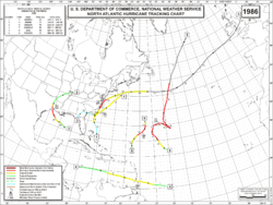
The 1986 Atlantic hurricane season officially began on June 1, 1986, and lasted until November 30, 1986. These dates conventionally delimit the period of each year when most tropical cyclones form in the Atlantic basin...
was a below-average season, having fewer named storms than in a normal year, with only ten tropical cyclones, six tropical storms, four hurricanes, and no major hurricanes. The season officially began on June 1, 1986 and ended on November 30, with the first storm, Tropical Storm Andrew forming on June 5, and the final storm, Hurricane Frances, dissipated on November 21. This timeline includes information that was not operationally released, meaning that information from post-storm reviews by the National Hurricane Center
National Hurricane Center
The National Hurricane Center , located at Florida International University in Miami, Florida, is the division of the National Weather Service responsible for tracking and predicting weather systems within the tropics between the Prime Meridian and the 140th meridian west poleward to the 30th...
, such as a storm that was not operationally warned upon, has been included. This timeline documents tropical cyclone
Tropical cyclone
A tropical cyclone is a storm system characterized by a large low-pressure center and numerous thunderstorms that produce strong winds and heavy rain. Tropical cyclones strengthen when water evaporated from the ocean is released as the saturated air rises, resulting in condensation of water vapor...
formations, strengthening, weakening, landfalls
Landfall (meteorology)
Landfall is the event of a tropical cyclone or a waterspout coming onto land after being over water. When a waterspout makes landfall it is reclassified as a tornado, which can then cause damage inland...
, extratropical transitions, as well as dissipations during the season.
June
June 1- The 1986 Atlantic hurricane season1986 Atlantic hurricane seasonThe 1986 Atlantic hurricane season officially began on June 1, 1986, and lasted until November 30, 1986. These dates conventionally delimit the period of each year when most tropical cyclones form in the Atlantic basin...
officially begins.
June 4
- 8:00 p.m. EDT (0000 UTC June 5) - Subtropical Depression One formed near the Bahamas.
June 5
- 8:00 p.m. EDT (0000 UTC June 6) Subtropical Depression One acquired tropical characteristics and strengthened into Tropical Storm AndrewTropical Storm Andrew (1986)Tropical Storm Andrew was a small, moderate tropical storm that formed in early June 1986. The first named storm of the 1986 Atlantic hurricane season, Andrew developed from a large, northward bound area of disturbed weather. Although it reached its peak intensity as a tropical storm, the initial...
.
- 8:00 a.m. EDT (1200 UTC) Tropical Storm Andrew attained its peak intensity with winds of 50 mph (85 km/h) and a minimum barometric pressure of 999 mbarBar (unit)The bar is a unit of pressure equal to 100 kilopascals, and roughly equal to the atmospheric pressure on Earth at sea level. Other units derived from the bar are the megabar , kilobar , decibar , centibar , and millibar...
(hPaPascal (unit)The pascal is the SI derived unit of pressure, internal pressure, stress, Young's modulus and tensile strength, named after the French mathematician, physicist, inventor, writer, and philosopher Blaise Pascal. It is a measure of force per unit area, defined as one newton per square metre...
; 29.5 inHg).
June 8
- 8:00 p.m. EDT (0000 UTC June 9) - Tropical Storm Andrew was absorbed by a low pressure system.
June 23
- 1:00 p.m. CDT (1800 UTC) - Tropical Depression Two formed in the eastern Gulf of MexicoGulf of MexicoThe Gulf of Mexico is a partially landlocked ocean basin largely surrounded by the North American continent and the island of Cuba. It is bounded on the northeast, north and northwest by the Gulf Coast of the United States, on the southwest and south by Mexico, and on the southeast by Cuba. In...
.
June 24
- 1:00 p.m. CDT (1800 UTC) - Tropical Depression Two strengthened into Tropical Storm Bonnie.
June 25
- 1:00 p.m. CDT (1800 UTC) - Tropical Storm Bonnie strengthened into Hurricane BonnieHurricane Bonnie (1986)Hurricane Bonnie was the second named storm, and first hurricane of the 1986 Atlantic hurricane season. Forming on June 23, Bonnie developed out of an area of low pressure over the central Gulf of Mexico. The system gradually intensified and was declared Tropical Storm Bonnie the next day as...
.
June 26
- 4:00 a.m. CDT (0900 UTC) - Hurricane Bonnie attained its peak intensity with winds of 85 mph (140 km/h) and a minimum pressure of 990 mbar (hPa; 29.23 inHg).
- 5:00 a.m. CDT (1000 UTC) - Hurricane Bonnie made landfall High Island, TexasHigh Island, TexasHigh Island is an unincorporated area located in the Bolivar Peninsula census-designated place, Galveston County, Texas, United States. The community is located in the extreme eastern part of the county on Bolivar Peninsula, less than one mile from Chambers County and less than two miles from...
with winds of 85 mph (140 km/h). - 1:00 p.m. CDT (1800 UTC) - Hurricane Bonnie weakened back to a tropical storm.
- 7:00 p.m. CDT (0000 UTC June 27) - Tropical Storm Bonnie weakened back to a tropical depression.
June 28
- 7:00 a.m. CDT (1200 UTC) - Tropical Depression Bonnie dissipated in MissouriMissouriMissouri is a US state located in the Midwestern United States, bordered by Iowa, Illinois, Kentucky, Tennessee, Arkansas, Oklahoma, Kansas and Nebraska. With a 2010 population of 5,988,927, Missouri is the 18th most populous state in the nation and the fifth most populous in the Midwest. It...
.
July
- Unknown time: - Tropical Depression Three formed 180 miles (290 km) north of BermudaBermudaBermuda is a British overseas territory in the North Atlantic Ocean. Located off the east coast of the United States, its nearest landmass is Cape Hatteras, North Carolina, about to the west-northwest. It is about south of Halifax, Nova Scotia, Canada, and northeast of Miami, Florida...
.
July 28
- Unknown time: - Tropical Depression Three had dissipated.
August
August 4- Unknown time: An operationally unnoticed tropical depression formed in the western Gulf of Mexico.
August 5
- Unknown time: - The unnoticed tropical depression made landfall in North Padre IslandNorth Padre IslandNorth Padre Island is a barrier island along the coast of Texas. It is located between Padre Island and Mustang Island. Most of the island is in the city of Corpus Christi. North Padre Island is one of the major surf areas on the Texas Gulf Coast....
, winds at landfall where unknown.
August 13
- 8:00 a.m. EDT (1200 UTC) - A second subtropical depression formed over the Florida PanhandleFlorida PanhandleThe Florida Panhandle, an informal, unofficial term for the northwestern part of Florida, is a strip of land roughly 200 miles long and 50 to 100 miles wide , lying between Alabama on the north and the west, Georgia also on the north, and the Gulf of Mexico to the south. Its eastern boundary is...
.
August 15
- 8:00 a.m. EDT (1200 UTC) - The subtropical depression transitioned into a tropical depression 70 miles (110 km) southeast of Charleston, South CarolinaCharleston, South CarolinaCharleston is the second largest city in the U.S. state of South Carolina. It was made the county seat of Charleston County in 1901 when Charleston County was founded. The city's original name was Charles Towne in 1670, and it moved to its present location from a location on the west bank of the...
. - 2:00 p.m. EDT (1800 UTC) - Tropical Depression Four strengthened into Tropical Storm Charley.
August 17
- 8:00 a.m. EDT (1200 UTC) - Tropical Storm Charley strengthened into Hurricane CharleyHurricane Charley (1986)Hurricane Charley was the costliest tropical cyclone of the 1986 Atlantic hurricane season. The third tropical storm and second hurricane of the season, Charley formed as a subtropical low on August 13 along the Florida panhandle. After moving off the coast of South Carolina, the system...
. - 10:00 a.m. EDT (1400 UTC) - Hurricane Charley made landfall near Cape Fear, North CarolinaNorth CarolinaNorth Carolina is a state located in the southeastern United States. The state borders South Carolina and Georgia to the south, Tennessee to the west and Virginia to the north. North Carolina contains 100 counties. Its capital is Raleigh, and its largest city is Charlotte...
with winds of 75 mph (120 km/h). - 6:00 p.m. EDT (2200 UTC) - Hurricane Charley attained its peak intensity with winds of 75 mph (120 km/h) and a minimum pressure of 987 mbar (hPa; 29.15 inHg).
- 8:00 a.m. EDT (1200 UTC) - Hurricane Charley weakened back to a tropical storm.
August 20
- 8:00 p.m. EDT (0000 UTC August 21) - Tropical Storm Charley transitioned into an extratropical storm.
August 31
- Unknown time: - Tropical Depression Five formed in the mid-Atlantic.
September
September 1- Unknown time: - Tropical Depression Six formed in the Gulf of Mexico.
September 4
- Unknown time: - Tropical Depression Five dissipated east-southeast of BermudaBermudaBermuda is a British overseas territory in the North Atlantic Ocean. Located off the east coast of the United States, its nearest landmass is Cape Hatteras, North Carolina, about to the west-northwest. It is about south of Halifax, Nova Scotia, Canada, and northeast of Miami, Florida...
. - Unknown time: - Tropical Depression Six made landfall in Altamira, TamaulipasTamaulipasTamaulipas officially Estado Libre y Soberano de Tamaulipas is one of the 31 states which, with the Federal District, comprise the 32 Federal Entities of Mexico. It is divided in 43 municipalities and its capital city is Ciudad Victoria. The capital city was named after Guadalupe Victoria, the...
, MexicoMexicoThe United Mexican States , commonly known as Mexico , is a federal constitutional republic in North America. It is bordered on the north by the United States; on the south and west by the Pacific Ocean; on the southeast by Guatemala, Belize, and the Caribbean Sea; and on the east by the Gulf of...
, winds were unknown.
September 7
- 2:00 a.m. EDT (0600 UTC) - Tropical Depression Seven formed several hundred miles east of the Windward IslandsWindward IslandsThe Windward Islands are the southern islands of the Lesser Antilles, within the West Indies.-Name and geography:The Windward Islands are called such because they were more windward to sailing ships arriving in the New World than the Leeward Islands, given that the prevailing trade winds in the...
. - 2:00 p.m. EDT (1800 UTC) - Tropical Depression Seven strengthened into Tropical Storm DanielleTropical Storm Danielle (1986)Tropical Storm Danielle was the only tropical storm to move through the Caribbean Sea in 1986. A short-lived cyclone, Danielle developed on September 7 to the east of the southern Lesser Antilles...
.
- 2:00 a.m. EDT (0600 UTC) - Tropical Storm Danielle attained its peak intensity with winds of 60 mph (95 km/h) and a minimum pressure of 1000 mbar (hPa; 29.53 inHg).
September 9
- 2:00 p.m. EDT (1800 UTC) - Tropical Storm Danielle weakened back to a tropical depression.
September 10
- 8:00 a.m. EDT (1200 UTC) - Tropical Depression Danielle dissipated in the western Caribbean SeaCaribbean SeaThe Caribbean Sea is a sea of the Atlantic Ocean located in the tropics of the Western hemisphere. It is bounded by Mexico and Central America to the west and southwest, to the north by the Greater Antilles, and to the east by the Lesser Antilles....
. - 2:00 p.m. EDT (1800 UTC) - Tropical Depression Eight 1240 miles (2000 km) east-northeast of Puerto Rico.
- 8:00 p.m. EDT (0000 UTC September 11) - Tropical Depression Eight strengthened into Tropical Storm Earl.
September 11
- 2:00 p.m. EDT (1800 UTC) - Tropical Storm Earl strengthened into Hurricane Earl.
September 12
- 8:00 a.m. EDT (1200 UTC) - Hurricane Earl strengthened into a category 2 hurricane.
September 14
- 8:00 a.m. EDT (1200 UTC) - Hurricane Earl attained its peak intensity with winds of 105 mph (165 km/h) and a minimum pressure of 979 mbar (hPa; 28.91 inHg).
September 15
- 8:00 p.m. EDT (0000 September 16) - Hurricane Earl weakened back to a category 1 hurricane.
September 18
- 8:00 p.m. EDT (0000 September 19) - Hurricane Earl transitioned into an extratropical.
November
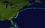
November 18- 2:00 p.m. EDT (1800 UTC) - Tropical Depression Nine formed north of the Leeward Islands.
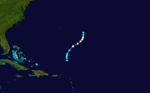
- 2:00 a.m. EDT (0600 UTC) - Tropical Depression Nine strengthened into Tropical Storm Frances.
November 20
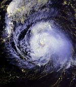
- 2:00 a.m. EDT (0600 UTC) - Tropical Storm Frances strengthened into Hurricane Frances.
- 8:00 a.m. EDT (1200 UTC) - Hurricane Frances attained its peak intensity with winds of 85 mph (140 km/h) and a minimum pressure of 1000 mbar (hPa; 29.53 inHg).
November 21
- 8:00 a.m. EDT (1200 UTC) - Hurricane Frances weakened back into a tropical storm.
- 8:00 p.m. EDT (0000 UTC November 22) - Tropical Storm Frances merged with an extratropical storm.
November 30
- The 1986 Atlantic hurricane season officially ended.
See also
- 1986 Atlantic hurricane season1986 Atlantic hurricane seasonThe 1986 Atlantic hurricane season officially began on June 1, 1986, and lasted until November 30, 1986. These dates conventionally delimit the period of each year when most tropical cyclones form in the Atlantic basin...
- List of Atlantic hurricane seasons