

Theodore Roosevelt Island
Encyclopedia
Theodore Roosevelt Island is a 88.5 acres (358,147.1 m²) island and a national memorial
located in the Potomac River
in Washington, D.C.
The island was given to the American people by the Theodore Roosevelt Association
in memory of the 26th U.S. president, Theodore Roosevelt
.
The island is maintained by the National Park Service
as part of the nearby George Washington Memorial Parkway
. The land is generally maintained as a natural park, with various trails and a memorial plaza featuring a statue of Roosevelt. No cars or bicycles are permitted on the island, which is reached by a footbridge from Arlington, Virginia, on the western bank of the Potomac.
A small island named "Little Island" lies just off the southern tip; Georgetown and the John F. Kennedy Center for the Performing Arts
are across the main channel of the Potomac to the north and east.
 The Nacotchtank
Indians, formerly of what is now Anacostia
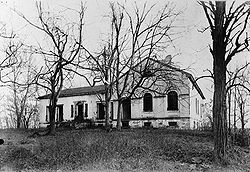
(in Washington, D.C.), temporarily moved to the island in 1668, giving its first recorded name, "Anacostine." The island was patented in 1682 as Anacostine Island by Captain Randolph Brandt, who left the island to his daughter Margaret Hammersley, upon his death in 1698 or 1699. The island was acquired by George Mason
in 1724. John Mason
, the son of George Mason, inherited the Island in 1792 and owned it until 1833. John Mason built a mansion and planted gardens there in the early 19th century. The Masons left the island in 1831 when a causeway
stagnated
the water.
Aside from a brief period in the Civil War
when Union troops were stationed there, the island has been uninhabited since the Masons left. Locals continued to call it "Mason's Island" until the memorial was built there. Around 1906, a fire on the island extensively damaged the mansion. Today, only part of the mansion's foundation remains. From 1913 to 1931, the island was owned by the Washington Gas Light Company, which allowed vegetation to grow unchecked on the island. The island has previously been known as My Lord's Island, Barbadoes Island, Mason's Island, Analostan Island, and Anacostine Island,
honoring Roosevelt. Congress
authorized the memorial on May 21, 1932, but did not appropriate funds for the memorial for almost three decades.
Funds were finally designated by Congress in 1960. As with all historic areas administered by the National Park Service, the national memorial is listed on the National Register of Historic Places
; the listing first appeared on October 15, 1966.
The memorial was dedicated on October 27, 1967. Designed by Eric Gugler, the memorial includes a 17-foot (5 m) statue by sculptor Paul Manship
, four large stone monoliths with some of Roosevelt's more famous quotations, and two large fountains.
estuary
, with the river water fresh but tidal
. A narrow channel separates the island from the Virginia
bank of the Potomac, with the main channel of the Potomac between the island and Georgetown, part of Washington, D.C. Surrounding scenery includes the Potomac Gorge
and Key Bridge, Georgetown, Rosslyn, and the Kennedy Center. Since the Virginia
state line
follows the southern bank of the river, the island is entirely in the District of Columbia.
The rocky western (upriver) and central portions of the island are part of the Piedmont Plateau
, while the southeastern part is within the Atlantic Coastal Plain
. At one point opposite Georgetown, the Atlantic Seaboard "Fall Line"
between the Piedmont and the Coastal Plain can be seen as a natural phenomenon. The island has about 2.5 miles (4 km) of shoreline, and the highest area of the island (where the Mason mansion stood) is about 44 feet (13.4 m) above sea level.
Spring floods coming down the Potomac from Appalachia
inundate low-lying portions of island's shores regularly, usually several times each year, while much larger floods, often from intense, widespread rainfall from tropical storms, flood the island more deeply several times a century. Storm surge
s coming up the Potomac from hurricanes or other coastal storm systems also cause occasional major floods affecting the island.
The island's vegetation
is quite diverse for a relatively small area, due to its geological and topographic variety, the frequency of floods, its land-use history (including various periods of landscaping
), and its location in an urban area in which many non-native species occur. Most of the island is deciduous forest
of various kinds, including uplands, riparian
shores, and swamp
s. There is also an area of fresh-water tidal (estuarine) marsh
, and a few small bedrock
outcrops of metamorphic Piedmont rock, some along the tidal shore. The variety of freshwater estuarine
intertidal habitat
s along the island's shores is particularly notable.
The island is particularly known for its variety of bird
s and its showy displays of spring wildflower
s. However, dozens of kinds of non-native invasive plants
have become abundant there, often locally outcompeting the native species.
, which crosses but does not allow access to the island. Cars can enter this parking lot only from the northbound lanes of the George Washington Memorial Parkway.
Pedestrians and bicylists can reach the parking lot and footbridge by following the Mount Vernon Trail
south from the intersection of Lee Highway and N. Lynn St. in Rosslyn, near Key Bridge. The closest Washington Metro
station to the island is the Rosslyn station
.
Several hiking trails provide access to the memorial and a variety of the island's natural habitats, including a boardwalk through a swampy and marshy area.
National Memorial
National Memorial is a designation in the United States for a protected area that memorializes a historic person or event. National memorials are authorized by the United States Congress...
located in the Potomac River
Potomac River
The Potomac River flows into the Chesapeake Bay, located along the mid-Atlantic coast of the United States. The river is approximately long, with a drainage area of about 14,700 square miles...
in Washington, D.C.
Washington, D.C.
Washington, D.C., formally the District of Columbia and commonly referred to as Washington, "the District", or simply D.C., is the capital of the United States. On July 16, 1790, the United States Congress approved the creation of a permanent national capital as permitted by the U.S. Constitution....
The island was given to the American people by the Theodore Roosevelt Association
Theodore Roosevelt Association
The Theodore Roosevelt Association is a historical and cultural organization dedicated to honoring the life and work of Theodore Roosevelt , the 26th president of the United States....
in memory of the 26th U.S. president, Theodore Roosevelt
Theodore Roosevelt
Theodore "Teddy" Roosevelt was the 26th President of the United States . He is noted for his exuberant personality, range of interests and achievements, and his leadership of the Progressive Movement, as well as his "cowboy" persona and robust masculinity...
.
The island is maintained by the National Park Service
National Park Service
The National Park Service is the U.S. federal agency that manages all national parks, many national monuments, and other conservation and historical properties with various title designations...
as part of the nearby George Washington Memorial Parkway
George Washington Memorial Parkway
The George Washington Memorial Parkway, known to local motorists simply as the "G.W. Parkway", is a parkway maintained by the U.S. National Park Service. It is located mostly in Northern Virginia, although a short section northwest of the Arlington Memorial Bridge passes over Columbia Island,...
. The land is generally maintained as a natural park, with various trails and a memorial plaza featuring a statue of Roosevelt. No cars or bicycles are permitted on the island, which is reached by a footbridge from Arlington, Virginia, on the western bank of the Potomac.
A small island named "Little Island" lies just off the southern tip; Georgetown and the John F. Kennedy Center for the Performing Arts
John F. Kennedy Center for the Performing Arts
The John F. Kennedy Center for the Performing Arts is a performing arts center located on the Potomac River, adjacent to the Watergate complex in Washington, D.C...
are across the main channel of the Potomac to the north and east.
History
Nacotchtank
The Nacotchtank were a native Algonquian people who lived in the area of what is now Washington, D.C. during the 17th century. Their principal village was situated within the modern borders of the District of Columbia, on the eastern bank of a small river that still bears an anglicised variant of...
Indians, formerly of what is now Anacostia
Anacostia
Anacostia is a historic neighborhood in Washington, D.C. Its historic downtown is located at the intersection of Good Hope Road and Martin Luther King, Jr. Avenue It is the most famous neighborhood in the Southeast quadrant of Washington, located east of the Anacostia River, after which the...
(in Washington, D.C.), temporarily moved to the island in 1668, giving its first recorded name, "Anacostine." The island was patented in 1682 as Anacostine Island by Captain Randolph Brandt, who left the island to his daughter Margaret Hammersley, upon his death in 1698 or 1699. The island was acquired by George Mason
George Mason
George Mason IV was an American Patriot, statesman and a delegate from Virginia to the U.S. Constitutional Convention...
in 1724. John Mason
John Mason (1766–1849)
John Mason was an early American merchant, banker, planter. As a son of George Mason, a Founding Father of the United States, Mason was a scion of the prominent Mason political family.-Early life and education:...
, the son of George Mason, inherited the Island in 1792 and owned it until 1833. John Mason built a mansion and planted gardens there in the early 19th century. The Masons left the island in 1831 when a causeway
Causeway
In modern usage, a causeway is a road or railway elevated, usually across a broad body of water or wetland.- Etymology :When first used, the word appeared in a form such as “causey way” making clear its derivation from the earlier form “causey”. This word seems to have come from the same source by...
stagnated
Water stagnation
Water stagnation occurs when water stops flowing. Stagnant water can be a major environmental hazard.-Dangers:Malaria and dengue are among the main dangers of stagnant water, which can become a breeding ground for the mosquitoes that transmit these diseases.Stagnant or Stailment water can be...
the water.
Aside from a brief period in the Civil War
American Civil War
The American Civil War was a civil war fought in the United States of America. In response to the election of Abraham Lincoln as President of the United States, 11 southern slave states declared their secession from the United States and formed the Confederate States of America ; the other 25...
when Union troops were stationed there, the island has been uninhabited since the Masons left. Locals continued to call it "Mason's Island" until the memorial was built there. Around 1906, a fire on the island extensively damaged the mansion. Today, only part of the mansion's foundation remains. From 1913 to 1931, the island was owned by the Washington Gas Light Company, which allowed vegetation to grow unchecked on the island. The island has previously been known as My Lord's Island, Barbadoes Island, Mason's Island, Analostan Island, and Anacostine Island,
National park and memorial
In 1931, the Theodore Roosevelt Memorial Association purchased the island from the gas company with the intention of erecting a memorialUnited States presidential memorial
The Presidential memorials in the United States honor the various Presidents of the United States and seek to perpetuate their legacies.-Living and physical elements:...
honoring Roosevelt. Congress
United States Congress
The United States Congress is the bicameral legislature of the federal government of the United States, consisting of the Senate and the House of Representatives. The Congress meets in the United States Capitol in Washington, D.C....
authorized the memorial on May 21, 1932, but did not appropriate funds for the memorial for almost three decades.
Funds were finally designated by Congress in 1960. As with all historic areas administered by the National Park Service, the national memorial is listed on the National Register of Historic Places
National Register of Historic Places
The National Register of Historic Places is the United States government's official list of districts, sites, buildings, structures, and objects deemed worthy of preservation...
; the listing first appeared on October 15, 1966.
The memorial was dedicated on October 27, 1967. Designed by Eric Gugler, the memorial includes a 17-foot (5 m) statue by sculptor Paul Manship
Paul Manship
Paul Howard Manship was an American sculptor.-Life:Manship began his art studies at the St. Paul School of Art in Minnesota. From there he moved to Philadelphia and continued his education at the Pennsylvania Academy of Fine Arts...
, four large stone monoliths with some of Roosevelt's more famous quotations, and two large fountains.
Geography and natural history
The Potomac River surrounding the island is at sea level, part of the Chesapeake BayChesapeake Bay
The Chesapeake Bay is the largest estuary in the United States. It lies off the Atlantic Ocean, surrounded by Maryland and Virginia. The Chesapeake Bay's drainage basin covers in the District of Columbia and parts of six states: New York, Pennsylvania, Delaware, Maryland, Virginia, and West...
estuary
Estuary
An estuary is a partly enclosed coastal body of water with one or more rivers or streams flowing into it, and with a free connection to the open sea....
, with the river water fresh but tidal
Tide
Tides are the rise and fall of sea levels caused by the combined effects of the gravitational forces exerted by the moon and the sun and the rotation of the Earth....
. A narrow channel separates the island from the Virginia
Virginia
The Commonwealth of Virginia , is a U.S. state on the Atlantic Coast of the Southern United States. Virginia is nicknamed the "Old Dominion" and sometimes the "Mother of Presidents" after the eight U.S. presidents born there...
bank of the Potomac, with the main channel of the Potomac between the island and Georgetown, part of Washington, D.C. Surrounding scenery includes the Potomac Gorge
Mather Gorge
Mather Gorge is a river gorge south and just downriver of Great Falls on the border of Maryland and Virginia. The Maryland side of the gorge is Bear Island, part of the Chesapeake and Ohio Canal National Historical Park, and the Virginia side is part of Great Falls Park. Both parks are National...
and Key Bridge, Georgetown, Rosslyn, and the Kennedy Center. Since the Virginia
Virginia
The Commonwealth of Virginia , is a U.S. state on the Atlantic Coast of the Southern United States. Virginia is nicknamed the "Old Dominion" and sometimes the "Mother of Presidents" after the eight U.S. presidents born there...
state line
Border
Borders define geographic boundaries of political entities or legal jurisdictions, such as governments, sovereign states, federated states and other subnational entities. Some borders—such as a state's internal administrative borders, or inter-state borders within the Schengen Area—are open and...
follows the southern bank of the river, the island is entirely in the District of Columbia.
The rocky western (upriver) and central portions of the island are part of the Piedmont Plateau
Piedmont (United States)
The Piedmont is a plateau region located in the eastern United States between the Atlantic Coastal Plain and the main Appalachian Mountains, stretching from New Jersey in the north to central Alabama in the south. The Piedmont province is a physiographic province of the larger Appalachian division...
, while the southeastern part is within the Atlantic Coastal Plain
Atlantic Coastal Plain
The Atlantic coastal plain has both low elevation and low relief, but it is also a relatively flat landform extending from the New York Bight southward to a Georgia/Florida section of the Eastern Continental Divide, which demarcates the plain from the ACF River Basin in the Gulf Coastal Plain to...
. At one point opposite Georgetown, the Atlantic Seaboard "Fall Line"
Fall line
A fall line is a geomorphologic unconformity between an upland region of relatively hard crystalline basement rock and a coastal plain of softer sedimentary rock. A fall line is typically prominent when crossed by a river, for there will often be rapids or waterfalls...
between the Piedmont and the Coastal Plain can be seen as a natural phenomenon. The island has about 2.5 miles (4 km) of shoreline, and the highest area of the island (where the Mason mansion stood) is about 44 feet (13.4 m) above sea level.
Spring floods coming down the Potomac from Appalachia
Appalachia
Appalachia is a term used to describe a cultural region in the eastern United States that stretches from the Southern Tier of New York state to northern Alabama, Mississippi, and Georgia. While the Appalachian Mountains stretch from Belle Isle in Canada to Cheaha Mountain in the U.S...
inundate low-lying portions of island's shores regularly, usually several times each year, while much larger floods, often from intense, widespread rainfall from tropical storms, flood the island more deeply several times a century. Storm surge
Storm surge
A storm surge is an offshore rise of water associated with a low pressure weather system, typically tropical cyclones and strong extratropical cyclones. Storm surges are caused primarily by high winds pushing on the ocean's surface. The wind causes the water to pile up higher than the ordinary sea...
s coming up the Potomac from hurricanes or other coastal storm systems also cause occasional major floods affecting the island.
The island's vegetation
Vegetation
Vegetation is a general term for the plant life of a region; it refers to the ground cover provided by plants. It is a general term, without specific reference to particular taxa, life forms, structure, spatial extent, or any other specific botanical or geographic characteristics. It is broader...
is quite diverse for a relatively small area, due to its geological and topographic variety, the frequency of floods, its land-use history (including various periods of landscaping
Landscaping
Landscaping refers to any activity that modifies the visible features of an area of land, including:# living elements, such as flora or fauna; or what is commonly referred to as gardening, the art and craft of growing plants with a goal of creating a beautiful environment within the landscape.#...
), and its location in an urban area in which many non-native species occur. Most of the island is deciduous forest
Temperate deciduous forest
A temperate deciduous forest, more precisely termed temperate broadleaf forest or temperate broadleaved forest, is a biome found in North America, southern South America, Europe, and Asia. A temperate deciduous forest consists of trees that lose their leaves every year...
of various kinds, including uplands, riparian
Riparian zone
A riparian zone or riparian area is the interface between land and a river or stream. Riparian is also the proper nomenclature for one of the fifteen terrestrial biomes of the earth. Plant habitats and communities along the river margins and banks are called riparian vegetation, characterized by...
shores, and swamp
Swamp
A swamp is a wetland with some flooding of large areas of land by shallow bodies of water. A swamp generally has a large number of hammocks, or dry-land protrusions, covered by aquatic vegetation, or vegetation that tolerates periodical inundation. The two main types of swamp are "true" or swamp...
s. There is also an area of fresh-water tidal (estuarine) marsh
Marsh
In geography, a marsh, or morass, is a type of wetland that is subject to frequent or continuous flood. Typically the water is shallow and features grasses, rushes, reeds, typhas, sedges, other herbaceous plants, and moss....
, and a few small bedrock
Bedrock
In stratigraphy, bedrock is the native consolidated rock underlying the surface of a terrestrial planet, usually the Earth. Above the bedrock is usually an area of broken and weathered unconsolidated rock in the basal subsoil...
outcrops of metamorphic Piedmont rock, some along the tidal shore. The variety of freshwater estuarine
Estuary
An estuary is a partly enclosed coastal body of water with one or more rivers or streams flowing into it, and with a free connection to the open sea....
intertidal habitat
Habitat
* Habitat , a place where a species lives and grows*Human habitat, a place where humans live, work or play** Space habitat, a space station intended as a permanent settlement...
s along the island's shores is particularly notable.
The island is particularly known for its variety of bird
Bird
Birds are feathered, winged, bipedal, endothermic , egg-laying, vertebrate animals. Around 10,000 living species and 188 families makes them the most speciose class of tetrapod vertebrates. They inhabit ecosystems across the globe, from the Arctic to the Antarctic. Extant birds range in size from...
s and its showy displays of spring wildflower
Wildflower
A wildflower is a flower that grows wild, meaning it was not intentionally seeded or planted. Yet "wildflower" meadows of a few mixed species are sold in seed packets. The term "wildflower" has been made vague by commercial seedsmen who are interested in selling more flowers or seeds more...
s. However, dozens of kinds of non-native invasive plants
Invasive species
"Invasive species", or invasive exotics, is a nomenclature term and categorization phrase used for flora and fauna, and for specific restoration-preservation processes in native habitats, with several definitions....
have become abundant there, often locally outcompeting the native species.
Access
Theodore Roosevelt Island is accessible by a footbridge from a parking lot along the Virginia bank of the Potomac River, just north of the Theodore Roosevelt BridgeTheodore Roosevelt Bridge
The Theodore Roosevelt Bridge is located in Washington, D.C. It carries Interstate 66 and U.S. Highway 50 over the Potomac River near the Kennedy Center, connecting the Rosslyn area of Arlington, Virginia, with Washington...
, which crosses but does not allow access to the island. Cars can enter this parking lot only from the northbound lanes of the George Washington Memorial Parkway.
Pedestrians and bicylists can reach the parking lot and footbridge by following the Mount Vernon Trail
Mount Vernon Trail
The Mount Vernon Trail is a popular running and bike path in Northern Virginia that follows the west bank of the Potomac River from near Theodore Roosevelt Island to Mount Vernon. The northern, urban half is open and has views of Washington, D.C. across the river. The southern below Alexandria is...
south from the intersection of Lee Highway and N. Lynn St. in Rosslyn, near Key Bridge. The closest Washington Metro
Washington Metro
The Washington Metro, commonly called Metro, and unofficially Metrorail, is the rapid transit system in Washington, D.C., United States, and its surrounding suburbs. It is administered by the Washington Metropolitan Area Transit Authority , which also operates Metrobus service under the Metro name...
station to the island is the Rosslyn station
Rosslyn (Washington Metro)
Rosslyn is a rapid transit station on the Blue and Orange Lines of the Washington Metro in the Rosslyn neighborhood of Arlington, Virginia. One of three interchange points on the Metrorail system west of the Potomac River and located in a growing business district, Rosslyn is the busiest station...
.
Several hiking trails provide access to the memorial and a variety of the island's natural habitats, including a boardwalk through a swampy and marshy area.
See also
- List of islands of the United States
- List of islands on the Potomac River
External links
- Official NPS website: Theodore Roosevelt Island
- Theodore Roosevelt Association
- General John Mason House Information about the historical mansion that was located on the island.