
The Undercliff
Encyclopedia
The Undercliff is the name of several areas of landslip on the south coast of England
. They include ones on the Isle of Wight
; on the Dorset
-Devon
border near Lyme Regis
; on cliffs near Branscombe
in East Devon
; and at White Nothe
, Dorset
. All arose from slump of harder strata
over softer clay
, giving rise to irregular landscapes of peaks, gullies and slipped blocks, that have become densely vegetated due to their isolation and change of land use. The Kent
coast at Folkestone
and Sandgate
also has similar undercliff areas.
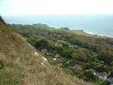
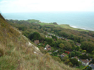 The Undercliff on the Isle of Wight
skirts the southern edge of the island from St Lawrence
, near Ventnor
in the east, to St. Catherine's Point, the southernmost point on the island. A favourable climate here has resulted in a semi-tropical environment like no other on the Island. This unique, attractive, tumbling landscape is mainly covered by lush vegetation.
The microclimate
of warm sunshine, moist air and few winter chills was recognised by leading physicians in Victorian
times as a beneficial environment for sufferers of respiratory diseases. This led to the establishment by Arthur Hill Hassall
of a chest hospital at Ventnor. While the hospital was closed in 1964 and demolished in 1969, its grounds were redeveloped as the twenty-two acre Ventnor Botanic Garden
, which takes advantage of the same mild conditions.
The development of Ventnor and St Lawrence during the mid-19th century saw the construction of many fine houses and villas, and the creation of some beautiful gardens. These developments included the now-demolished Steephill Castle
, and a number of houses built for the industrialist William Spindler
in the 1880s during his attempt, cut short by his death, to develop St Lawrence as a town.
The Undercliff is mostly accessible by a road, Undercliff Drive, running its length from Niton
to Ventnor. The road's low-level continuation between Niton and Blackgang
was broken by landslips in the 20th century. The Undercliff can been visited on foot by the Ventnor-Blackgang section of the Isle of Wight Coastal Path
.
There are some coastal erosion and landslip concerns associated with the Isle of Wight Undercliff region.
and Lyme Regis
includes unstable cliffs which have given rise to undercliff areas with varied topography. There was a mudslide at Stonebarrow
east of Charmouth in December 2000, and in May 2008 there was a large landslip at Black Ven
between Charmouth and Lyme Regis.
 The Undercliff in Dorset
-East Devon
stretches the 5 miles (8 km) between Lyme Regis
, near to the Cobb harbour, and Seaton
. Like its namesake on the Isle of Wight, this feature also arose as a result of landslips and has become a rare and unusual habitat for plants and birds. It is a National Nature Reserve
- the Axmouth to Lyme Regis Undercliffs NNR - and the South West Coast Path
runs through it. The footpath stretches for 7 - 8 miles (12.9 km) and is not accessible except at each end. It is not permitted to leave the path due to the nature reserve status and the dangerous terrain.
Some of the landslips that created the Undercliff took place within historical record. Recorded slips took place in 1775, 1828, 1839 (the Great Slip) and 1840. The 1839 slip was especially well-documented since the geologists Buckland
and Conybeare
were in the area to survey it. A large tract of land below Bindon Manor and Dowlands Farm slipped, creating the features now called Goat Island and the Chasm. It took with it an area of sown wheatfield which remained sufficiently undamaged for the wheat to be harvested in 1840, when the slip was a popular visitor attraction.
The Undercliff was formerly open rough pasture, grazed by sheep and rabbits, including features such as Donkey Green (an area of turf used for picnics and sports), Landslip Cottage (which used to sell teas to visitors), and Chapel Rock (where, according to tradition, Tudor
religious dissenter
s met). However, it become heavily overgrown in the 20th century following the cessation of sheep farming and the decline in rabbits due to myxomatosis
, and access is now difficult, the terrain being treacherous due to its unstable cliffs, deep gullies and dense undergrowth.
Sabine Baring-Gould
's 1900 novel Winefred, a story of the chalk cliffs is set in the Undercliff area, with the Great Slip as its climax. The Undercliff was also one of the settings for the novel The French Lieutenant's Woman
and a location for its film adaptation
.
and Branscombe
. A slump
in the Chalk
cliffs in 1790 separated a 10 acres (40,468.6 m²) tract of land, now a wooded and sheltered habitat with chalk pinnacles on the seaward side. It is reached via a steep footpath leading from the clifftop to Branscombe Beach.
and Sandgate
have undercliff areas formed by landslips. Folkestone Warren, since stabilised by sea defences to protect the Dover
-Folkestone railway that runs at its foot, is designated a SSSI and a nature reserve.
Cylindera germanica, the Chine beetle Drypta dentata, the Large mining bee Osmia xanthomelana, and Morris's Wainscot moth Chortodes morrisii morrisii.
England
England is a country that is part of the United Kingdom. It shares land borders with Scotland to the north and Wales to the west; the Irish Sea is to the north west, the Celtic Sea to the south west, with the North Sea to the east and the English Channel to the south separating it from continental...
. They include ones on the Isle of Wight
Isle of Wight
The Isle of Wight is a county and the largest island of England, located in the English Channel, on average about 2–4 miles off the south coast of the county of Hampshire, separated from the mainland by a strait called the Solent...
; on the Dorset
Dorset
Dorset , is a county in South West England on the English Channel coast. The county town is Dorchester which is situated in the south. The Hampshire towns of Bournemouth and Christchurch joined the county with the reorganisation of local government in 1974...
-Devon
Devon
Devon is a large county in southwestern England. The county is sometimes referred to as Devonshire, although the term is rarely used inside the county itself as the county has never been officially "shired", it often indicates a traditional or historical context.The county shares borders with...
border near Lyme Regis
Lyme Regis
Lyme Regis is a coastal town in West Dorset, England, situated 25 miles west of Dorchester and east of Exeter. The town lies in Lyme Bay, on the English Channel coast at the Dorset-Devon border...
; on cliffs near Branscombe
Branscombe
The Old Bakery, Manor Mill & Forge is a collection of buildings in Branscombe, Seaton, Devon, England. The property has been in the ownership of the National Trust since 1965.The property consists of three buildings: a bakery, a watermill and a forge....
in East Devon
East Devon
East Devon is a local government district in Devon, England. Its council is based in Sidmouth, and the largest town is Exmouth.The district was formed on 1 April 1974 by the merger of the borough of Honiton with the urban districts of Budleigh Salterton, Exmouth, Ottery St. Mary, Seaton, Sidmouth...
; and at White Nothe
White Nothe
White Nothe is a chalk headland on the English Channel coast at the eastern end of Ringstead Bay, east of Weymouth in Dorset, England. The area is well-known for its geology and fossils...
, Dorset
Dorset
Dorset , is a county in South West England on the English Channel coast. The county town is Dorchester which is situated in the south. The Hampshire towns of Bournemouth and Christchurch joined the county with the reorganisation of local government in 1974...
. All arose from slump of harder strata
Stratum
In geology and related fields, a stratum is a layer of sedimentary rock or soil with internally consistent characteristics that distinguish it from other layers...
over softer clay
Clay
Clay is a general term including many combinations of one or more clay minerals with traces of metal oxides and organic matter. Geologic clay deposits are mostly composed of phyllosilicate minerals containing variable amounts of water trapped in the mineral structure.- Formation :Clay minerals...
, giving rise to irregular landscapes of peaks, gullies and slipped blocks, that have become densely vegetated due to their isolation and change of land use. The Kent
Kent
Kent is a county in southeast England, and is one of the home counties. It borders East Sussex, Surrey and Greater London and has a defined boundary with Essex in the middle of the Thames Estuary. The ceremonial county boundaries of Kent include the shire county of Kent and the unitary borough of...
coast at Folkestone
Folkestone
Folkestone is the principal town in the Shepway District of Kent, England. Its original site was in a valley in the sea cliffs and it developed through fishing and its closeness to the Continent as a landing place and trading port. The coming of the railways, the building of a ferry port, and its...
and Sandgate
Sandgate, Kent
Sandgate is a village in the Folkestone and Hythe Urban Area in the Shepway district of Kent, England. In 2004, the village re-acquired civil parish status....
also has similar undercliff areas.
Isle of Wight
Isle of Wight
The Isle of Wight is a county and the largest island of England, located in the English Channel, on average about 2–4 miles off the south coast of the county of Hampshire, separated from the mainland by a strait called the Solent...
skirts the southern edge of the island from St Lawrence
St Lawrence, Isle of Wight
St Lawrence is a village on the south side of the Isle of Wight, in southern England. It is located to the west of Ventnor and many consider it a part of that town. St Lawrence is situated on the Undercliff, and is subject to regular landslips.-Features:...
, near Ventnor
Ventnor
Ventnor is a seaside resort and civil parish established in the Victorian era on the south coast of the Isle of Wight, England. It lies underneath St Boniface Down , and is built on steep slopes and cliffs leading down to the sea...
in the east, to St. Catherine's Point, the southernmost point on the island. A favourable climate here has resulted in a semi-tropical environment like no other on the Island. This unique, attractive, tumbling landscape is mainly covered by lush vegetation.
The microclimate
Microclimate
A microclimate is a local atmospheric zone where the climate differs from the surrounding area. The term may refer to areas as small as a few square feet or as large as many square miles...
of warm sunshine, moist air and few winter chills was recognised by leading physicians in Victorian
Victorian era
The Victorian era of British history was the period of Queen Victoria's reign from 20 June 1837 until her death on 22 January 1901. It was a long period of peace, prosperity, refined sensibilities and national self-confidence...
times as a beneficial environment for sufferers of respiratory diseases. This led to the establishment by Arthur Hill Hassall
Arthur Hill Hassall
Arthur Hill Hassall was a British physician, chemist and microscopist who is primarily known for his work in public health and food safety....
of a chest hospital at Ventnor. While the hospital was closed in 1964 and demolished in 1969, its grounds were redeveloped as the twenty-two acre Ventnor Botanic Garden
Ventnor Botanic Garden
Ventnor Botanic Garden is a botanic garden located in Ventnor, Isle of Wight. It was founded in 1970, by Sir Harold Hillier, and donated to the Isle of Wight Council. The garden is free to visit, except for parking charges....
, which takes advantage of the same mild conditions.
The development of Ventnor and St Lawrence during the mid-19th century saw the construction of many fine houses and villas, and the creation of some beautiful gardens. These developments included the now-demolished Steephill Castle
Steephill
Steephill is a hamlet near Ventnor, Isle of Wight, previously the location of a Victorian country estate with a castle-style mansion, Steephill Castle, which was demolished to build bungalows in the 1960s...
, and a number of houses built for the industrialist William Spindler
William Spindler
William Spindler, born in Guatemala City, Guatemala in 1963. He is a Guatemalan writer and journalist, whose works include fiction, poetry, and journalism in English and Spanish. He is the author of a novel Paises lejanos, and a book of short stories, “Expediciones”, published in Bogota, Colombia...
in the 1880s during his attempt, cut short by his death, to develop St Lawrence as a town.
The Undercliff is mostly accessible by a road, Undercliff Drive, running its length from Niton
Niton, Isle of Wight
Niton is a village on the Isle of Wight, near Ventnor with a thriving population of 1142, supporting two pubs, several churches,a pottery workshop/shop, a pharmacy and 3 local shops including a post office...
to Ventnor. The road's low-level continuation between Niton and Blackgang
Blackgang
Blackgang is a village on the south coast of the Isle of Wight. It is best known as the location of the Blackgang Chine amusement park which sits to the south of St Catherine's Down....
was broken by landslips in the 20th century. The Undercliff can been visited on foot by the Ventnor-Blackgang section of the Isle of Wight Coastal Path
Isle of Wight Coastal Path
.There are a couple of cafes on the cliff path which I believe are open in the summer months. The only public convenience on the cliff path now appears to be closed permanently ....
.
There are some coastal erosion and landslip concerns associated with the Isle of Wight Undercliff region.
West Dorset
The west Dorset coast around CharmouthCharmouth
Charmouth is a village at the mouth of the River Char in West Dorset, England, with a population of 1,687 according to the 2001 census.-The village:...
and Lyme Regis
Lyme Regis
Lyme Regis is a coastal town in West Dorset, England, situated 25 miles west of Dorchester and east of Exeter. The town lies in Lyme Bay, on the English Channel coast at the Dorset-Devon border...
includes unstable cliffs which have given rise to undercliff areas with varied topography. There was a mudslide at Stonebarrow
Stonebarrow
Stonebarrow is a clifface in the county of Dorset, England. It is a well known fossil hunting location close to the famous fossil hunting town of Charmouth.- Geography:...
east of Charmouth in December 2000, and in May 2008 there was a large landslip at Black Ven
Black Ven
Black Ven is a cliff in Dorset, England. It is part of the Jurassic Coast World Heritage site. The cliff is famous for its mudslides, in fact, it has the largest mudslides in Europe. The area is popular with tourists because a number of fossils are found in the area.- History :The Black Ven has...
between Charmouth and Lyme Regis.
Axmouth to Lyme Regis
Dorset
Dorset , is a county in South West England on the English Channel coast. The county town is Dorchester which is situated in the south. The Hampshire towns of Bournemouth and Christchurch joined the county with the reorganisation of local government in 1974...
-East Devon
East Devon
East Devon is a local government district in Devon, England. Its council is based in Sidmouth, and the largest town is Exmouth.The district was formed on 1 April 1974 by the merger of the borough of Honiton with the urban districts of Budleigh Salterton, Exmouth, Ottery St. Mary, Seaton, Sidmouth...
stretches the 5 miles (8 km) between Lyme Regis
Lyme Regis
Lyme Regis is a coastal town in West Dorset, England, situated 25 miles west of Dorchester and east of Exeter. The town lies in Lyme Bay, on the English Channel coast at the Dorset-Devon border...
, near to the Cobb harbour, and Seaton
Seaton, Devon
Seaton is a seaside town in East Devon on the south coast of England. It faces onto Lyme Bay, to the west of the mouth of the River Axe with red cliffs to one side and white cliffs on the other. Axmouth and Beer are nearby...
. Like its namesake on the Isle of Wight, this feature also arose as a result of landslips and has become a rare and unusual habitat for plants and birds. It is a National Nature Reserve
National Nature Reserve
For details of National nature reserves in the United Kingdom see:*National Nature Reserves in England*National Nature Reserves in Northern Ireland*National Nature Reserves in Scotland*National Nature Reserves in Wales...
- the Axmouth to Lyme Regis Undercliffs NNR - and the South West Coast Path
South West Coast Path
The South West Coast Path is Britain's longest waymarked long-distance footpath and a National Trail. It stretches for , running from Minehead in Somerset, along the coasts of Devon and Cornwall, to Poole Harbour in Dorset. Since it rises and falls with every river mouth, it is also one of the more...
runs through it. The footpath stretches for 7 - 8 miles (12.9 km) and is not accessible except at each end. It is not permitted to leave the path due to the nature reserve status and the dangerous terrain.
Some of the landslips that created the Undercliff took place within historical record. Recorded slips took place in 1775, 1828, 1839 (the Great Slip) and 1840. The 1839 slip was especially well-documented since the geologists Buckland
William Buckland
The Very Rev. Dr William Buckland DD FRS was an English geologist, palaeontologist and Dean of Westminster, who wrote the first full account of a fossil dinosaur, which he named Megalosaurus...
and Conybeare
William Daniel Conybeare
William Daniel Conybeare FRS , dean of Llandaff, was an English geologist, palaeontologist and clergyman. He is probably best known for his ground-breaking work on marine reptile fossils in the 1820s, including important papers for the Geological Society of London on ichthyosaur anatomy and the...
were in the area to survey it. A large tract of land below Bindon Manor and Dowlands Farm slipped, creating the features now called Goat Island and the Chasm. It took with it an area of sown wheatfield which remained sufficiently undamaged for the wheat to be harvested in 1840, when the slip was a popular visitor attraction.
The Undercliff was formerly open rough pasture, grazed by sheep and rabbits, including features such as Donkey Green (an area of turf used for picnics and sports), Landslip Cottage (which used to sell teas to visitors), and Chapel Rock (where, according to tradition, Tudor
Tudor dynasty
The Tudor dynasty or House of Tudor was a European royal house of Welsh origin that ruled the Kingdom of England and its realms, including the Lordship of Ireland, later the Kingdom of Ireland, from 1485 until 1603. Its first monarch was Henry Tudor, a descendant through his mother of a legitimised...
religious dissenter
Dissenter
The term dissenter , labels one who disagrees in matters of opinion, belief, etc. In the social and religious history of England and Wales, however, it refers particularly to a member of a religious body who has, for one reason or another, separated from the Established Church.Originally, the term...
s met). However, it become heavily overgrown in the 20th century following the cessation of sheep farming and the decline in rabbits due to myxomatosis
Myxomatosis
Myxomatosis is a disease that affects rabbits and is caused by the Myxoma virus. It was first observed in Uruguay in laboratory rabbits in the late 19th century. It was introduced into Australia in 1950 in an attempt to control the rabbit population...
, and access is now difficult, the terrain being treacherous due to its unstable cliffs, deep gullies and dense undergrowth.
Sabine Baring-Gould
Sabine Baring-Gould
The Reverend Sabine Baring-Gould was an English hagiographer, antiquarian, novelist and eclectic scholar. His bibliography consists of more than 1240 publications, though this list continues to grow. His family home, Lew Trenchard Manor near Okehampton, Devon, has been preserved as he had it...
's 1900 novel Winefred, a story of the chalk cliffs is set in the Undercliff area, with the Great Slip as its climax. The Undercliff was also one of the settings for the novel The French Lieutenant's Woman
The French Lieutenant's Woman
The French Lieutenant’s Woman , by John Fowles, is a period novel inspired by the 1823 novel Ourika, by Claire de Duras, which Fowles translated into English in 1977...
and a location for its film adaptation
The French Lieutenant's Woman (film)
The French Lieutenant's Woman is a 1981 film directed by Karel Reisz and adapted by playwright Harold Pinter. It is based on the novel of the same title by John Fowles...
.
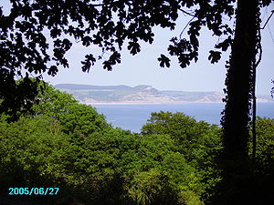
Hooken
The Hooken Undercliff is on the cliff route between Beer, DevonBeer, Devon
The village of Beer is in south-east Devon, England, on Lyme Bay.- Location :The village of Beer is situated on the 95-mile long Jurassic Coast, England's first natural World Heritage Site and its picturesque cliffs, including Beer Head, form part of the South West Coast Path.Beer lies about two...
and Branscombe
Branscombe
The Old Bakery, Manor Mill & Forge is a collection of buildings in Branscombe, Seaton, Devon, England. The property has been in the ownership of the National Trust since 1965.The property consists of three buildings: a bakery, a watermill and a forge....
. A slump
Slump
A Slump is a form of mass wasting that occurs when a coherent mass of loosely consolidated materials or rock layers moves a short distance down a slope. Movement is characterized by sliding along a concave-upward or planar surface...
in the Chalk
Chalk Formation
The Chalk Group is a lithostratigraphic unit in the northwestern part of Europe. It is characterised by thick deposits of chalk, a soft porous white limestone, deposited in a marine environment during the Upper Cretaceous period.Chalk is a limestone that consists of coccolith biomicrite...
cliffs in 1790 separated a 10 acres (40,468.6 m²) tract of land, now a wooded and sheltered habitat with chalk pinnacles on the seaward side. It is reached via a steep footpath leading from the clifftop to Branscombe Beach.
Kent
The towns of FolkestoneFolkestone
Folkestone is the principal town in the Shepway District of Kent, England. Its original site was in a valley in the sea cliffs and it developed through fishing and its closeness to the Continent as a landing place and trading port. The coming of the railways, the building of a ferry port, and its...
and Sandgate
Sandgate, Kent
Sandgate is a village in the Folkestone and Hythe Urban Area in the Shepway district of Kent, England. In 2004, the village re-acquired civil parish status....
have undercliff areas formed by landslips. Folkestone Warren, since stabilised by sea defences to protect the Dover
Dover
Dover is a town and major ferry port in the home county of Kent, in South East England. It faces France across the narrowest part of the English Channel, and lies south-east of Canterbury; east of Kent's administrative capital Maidstone; and north-east along the coastline from Dungeness and Hastings...
-Folkestone railway that runs at its foot, is designated a SSSI and a nature reserve.
Undercliff wildlife
These sections of undercliff represent some of the most important sites in the UK for the conservation of rare beetles, bees and other invertebrates. Coastal soft cliffs and slopes support a specialised assemblage of species reliant on a historical continuity of bare ground, pioneer vegetation habitats, and freshwater seepages. Rare species entirely restricted to soft cliffs in the UK include the Cliff tiger beetleTiger beetle
The tiger beetles are a large group of beetles known for their aggressive predatory habits and running speed. The fastest species of tiger beetle can run at a speed of 9 km/h , which, relative to its body length, is about 22 times the speed of former Olympic sprinter Michael Johnson, the...
Cylindera germanica, the Chine beetle Drypta dentata, the Large mining bee Osmia xanthomelana, and Morris's Wainscot moth Chortodes morrisii morrisii.
External links
- Website with old pictures of the Undercliff of the Isle of Wight
- Old views of the Undercliff
- Contemporary colour illustrations of the 1839 and 1840 Devon landslips
- Jurassic Coast information on the Dorset Undercliff
- The axmouth to LymeRegis Undercliff
- The Hooken Undercliff, Branscombe
- Buglife website (more information about soft cliff invertebrates)