

Dunlop, East Ayrshire
Encyclopedia
Dunlop is a village and parish in East Ayrshire
, Scotland
. It lies on the A735, north-east of Stewarton
, seven miles from Kilmarnock
. The road runs on to Lugton
and the B706 enters the village from Beith
.
 In the 1600s Dunloppe had two fairs a year for the sale of dairy stock, one on the second Friday of May; and the other called Hallowday, on the 12th. of November. The Estate was erected into the Barony of Dunlop in 1688. Dunlap, Dunlapp, Dunlape, Dunlopp, Dunlope, Dunloup, Downlop, Dalape, Delap, DeLap, Delappe, Dulop, Dulap, Dulape, Dullope, Donlop, Donlap, Dounlap, Dunlip, Dewlap are all recorded variations of today's Dunlop.
Dunlop cheese
, a sweet milk cheese, was first made by Barbara Gilmour
who went to Ireland to escape the covenanting prosecutions. Her stone cheese press was said to be preserved at 'The Hill' Farm in the 1860s, but the existing press is dated after her death. The cheese became World famous and created a cottage industry with cheese merchants from Kirktoun buying up the cheeses and taking them to Glasgow for sale. The cheese making used up excess fresh milk and the coming of the railways reduced the need for cheese manufacture. Dunlop cheeses are still made at Clerkland Farm (2010).
Tam Giffen was reputed to be a warlock
from the Dunlop Parish and many anecdotes are told of his marvellous doings in the 1860s. Tam could not get over the flood swollen Lugton Waster so he just ....came through below it. On another occasion he was prevented from helping the Devil blow a man off the thatched roof he was repairing by the man uttering God save me and had to make do with blowing off the man's wig and bonnet; finally he once entered a blacksnith's house by flying down the chimney. Tam died in odd circumstances, supposedly being murdered by the fairies
for giving away their secrets.
In 1791 Dunlop is recorded as having six masons, twelve weavers, three smiths, three shoemakers, four tailors and three inn-keepers; by 1874 the village had 10 shoemakers, 8 masons, 6 weavers, 6 smiths, 5 wrights and 1 taylor, but no baker or flesher and the people's health was such that no surgeon was need or writer (lawyer). 1823 saw 'Mackie's Mill', producing woolen blankets, being set up on the banks of the Glazert Water and by 1939 Mackie's Mill was producing carpet yarn and had also branched out to establish two more manufacturing sites. In 1849 a Mr. Wilson set up shop as a ham curer. By the 1930s this ham curing business had diversified, and branched out into Ireland and had factories in Barrhead
and at Eglinton
in Irvine; the original curing house, known as the 'Burnhouse' has been landscaped and transformed into a local park thanks to funding from the Barcapel Foundation, previously the Clement Wilson Foundation. Robert Howie and sons started a small meal-mill in 1857, and then established a sawmill. They moved closer to the railway, where they remained until recently (2010).
The railway finally came to Dunlop in 1871 and because of the improved connection with Glasgow the farmers were able to send their milk directly into Glasgow, resulting in the decline and finally the cessation of cheese making in Dunlop. The population of the village in 1871 was 380 and 357 in 1881, whilst the parish was 1160 and 1361 persons respectively. In 1876 the town had acquired a butcher, a baker, a branch of the Clydesdale Bank
, as well as a Free Church (1845), but still no writer or doctor was needed. By the 1950s Dunlop had a post office, four grocers, a baker, a newsagent, a hotel, and a public House.
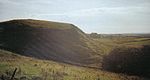
 A tradition states that the De Ross first held Boarland or Dunlop Hill (NS 4019 4940) as their seat and a well fortified structure existed there, later their seat was moved to Corsehill in Stewarton. A Celtic hillfort may have existed here, as suggested by the etymology of the placename.
 In 1848 the Scottish Journal records that a number of years ago the foundation of a ruin of considerable extent was removed by the late proprietor. In 1853 Mr. Dobie recorded that There can still be traced the meiths (boundary line) of a building of considerable extent on the top of the Hill of Borland. Mr. G. Howie, of Dunlop in 1856, stated that he remembered seeing a small portion of what was said to be one of the walls about 70 or 80 years ago. It was a sort of bank, quite crumbled down and overgrown with grass. Since then, the ruins of a building of considerable extent have been removed and the ground cultivated. On the southern side of the hill there are the remains of a wide ditch or fosse, locally known as the 'Cuckoo slide.' Paterson in 1866 states that the foundation of a ruin was removed some years ago by a late proprietor.
Pont states that the ancient strong Dunlop Castle situated by the Clerkland Burn (NS 42737 49312) was protected by a moat or fosse of water and had 'goodly' orchards. Smith records that the 'Airn Yett
' of the old castle was still preserved and its details published (see Wikimedia). It was also called Hunt Hall because the Dunlops were huntsmen to the De Ross family (Paterson 1866). The whole estate was sometimes referred to as Hunt Hall. This castle was situated at the site of the present day Dunlop House.
The De Ross family were vassals to the De Morvilles, Overlords of Cunninghame. The De Morvilles backed John Balliol's claim to the crown and forfeited their lands to the Boyds, and in 1570 the lands were held by the Cassillis family. In 1600 it is noted that David Dunlop of Hapland excambied
his lands with Patrick Cunninghame for his portion of the lands of Borland.
The native chiefs, although displaced from Boarland Hill do not appear to have been exiled, instead they established themselves at what is now Dunlop House. The name Boarland also survives in the names of Borlandhill, Over Borland, North Borland and Low Borland. The name Boarland could refer to the presence of wild boar, however a 'Boor' also meant a serf and Norman lords often apportioned lands near their castles for their servants. The Borland or Bordland also meant the land that was granted to the feudal superior specifically to be used to furnish food for his castle or dwelling.
There has been a modern day military use of Dunlop Hill, for in the 20th-century, between the two World Wars, a Royal Observer Corps
post was built into the west facing side of the hill. The personnel tracked enemy aircraft movement up the Clyde
towards Glasgow. Development of more sophisticated radar
tracking techniques after World War 2 made the facility redundant.
 The first recorded Dunlop is William de Dunlop of 1260, followed by a supporter of Edward I, Neil Fitz-Robert de Dulap of 1306. His estates were forfeited due to his support for John Balliol, as were those of the De Rosses. The family regained their lands by the mid 15th. Century and by that time we have 'of that Ilk' replacing the Norman 'de'. Sir James Dunlop of that Ilk held the estate in 1596 and married Jean, daughter of Somerville of Cambusnethan, descended from Lord Somerville. This may go some way to explaining why the Somerville family came to purchase lands at Montgomery-Crivoch and Bollingshaw in the 1800s to establish the Kennox Estate
.
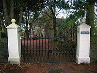
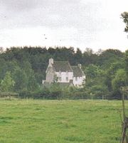
Francis Dunlop was a witness to the disposition of the Scottish Regalia in Edinburgh Castle after the Union of the Crowns. James Dunlop of 1634-1670 married Elizabeth, daughter of Cunninghame of Corsehill and was an outstanding leader of the covenanters. John Dunlop 1748-1784 married the daughter of Sir Thomas Wallace of Craigie.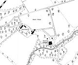 She was the patron of Burns already referred to. John Dunlop Esq. MP was resident at Dunlop House in 1837 and Pigot describes it as one of Ayrshires' handsomest mansions, with the Ogrestone or Thurgatstane lying within its estate boundaries. The house was designed in 1831-34 by David Hamilton for Sir James Dunlop of Dunlop. The house is an unusual Scottish-Jacobean style, but the gate lodge is more typical of Hamilton, with strap work, classical and manorial features (Milligan). The last Baronet was Major Sir James Dunlop of 1839-1858 who died unmarried.
The last of the Dunlops to be born at Dunlop were John (1904) and Alexander (1906) Houison Crawfurd. Mrs Houison Crawfurd is remembered for producing the first tubercular-free cattle in Ayrshire. The house was let to a number of tenants, the Henderson family of the Anchor Line being the most notable. In 1933 the house was sold to Ayrshire County Council as a home for mentally defective children.
The Clerkland Burn rivulet runs past the Dunlop House mansion, forming the boundary between the parishes of Stewarton and Dunlop.
. It is said to be the site of the death of one of the Cunninghames of Aiket, killed by a Montgomerie during the times of the feuds between these families.
Image:Braikenheuch cairn Dunlop.JPG|The cairn at the Dunlop Millennium Communiy Woodland
Image:Braikenheuch Hill Dunlop.JPG|A view of Braikenheugh Hill, the bridge, etc.
Image:Dunlop millennium community woodland.JPG|The view from the Templehouse woodland
File:The Braikenheugh from Aiket Castle..JPG|The Brackenheugh from Aiket Castle
held the post of vicar, mostly absentee as he was a professor of theology. By 1566 the vicar was was John Houston, who held the manse, garden and an acre of land adjoining the manse. The rest of the Kirkland-Dunlop lands passed from the Abbots of Kilwinning to William Cunninghame of Aiket and remained with the Cunninghames until the latter half of the 17th century. The Earl of Eglinton held the right of patronage when it was abolished in 1875.
 The church (NS 40474 49414) was probably built in around 1766, however by 1834 it was dilapidated and demolition followed, resulting in the construction of the Dunlop parish church, opened in December 1835, that we see today. This was took place under the ministry of Mathew Dickie, who left to join the Free Church at Beith in 1843. Parts of the original building are in use as tomb stones. Barbara Gilmour
, famous for introducing the production of Dunlop cheese
, is buried in the churchyard. Major McAlester of Kennox
, then a heritor, obtained the 1792 bell and Miss McAlester and Charles G. S. McAlester returned it to the Kirk Session in 1935 to honour the centenary of the present church. son of Hans Hamilton, first Protestant minister of Dunlop Parish. In 1839 a new school was opened.
The Rev William Gebbie was the last minister to come into the parish under the old system of patronage, in this case that of the Earl of Eglinton
. William was a fervent evangelist and the 'Dunlop Revival' shook the whole parish until the reverend was charged with heresy in the early 1860s. He remained as minister until 1883.
The old manse was sold and a new manse and offices were built by the heritors under the incumbency of Thomas Brisbane in 1781. This manse adjoined the 7 acres of the glebe and was extended by the Revd Dickie. The Kirktoun of Dunlop composed the manses and a row of cottages dated 1644, 1765, 1773, etc.
was created Viscount Claneboye for his many services to James VI in establishing and maintaining Protestantism in Ireland
; his son James was in turn created Earl Clanbrassil
by Charles I. His five brothers also established estates in Ireland. A handsome mausoleum (NS 40486 49398) was constructed over their graves by James in 1641, when he was in his eighties, and this was so ornately painted and gilded in the Roman Catholic manner that it attracted the sobriquet of 'The Picture House'. The flat tombstone of Hans Hamilton was originally on the floor, but this was later removed and placed on the south wall. It was much neglected and vandalised even in 1699, but in 1734 it was given some much needed repairs. Around 1849 Colonel Mure of Caldwell had further repairs carried out. The marble statues of Hans and his wife have now been removed to a place of safety for their protection (2005).
Jean Hamilton, the daughter of Hans Hamilton, had a dowary of 5000 merks in 1613.
Aiket Castle itself was originally a square tower typical of the residences of the lesser feudal Norman barons, originally surrounded by a moat. The name is derived from 'Oak Wood'. The family were descended from the Cunninghames of Bedland, who were cadets of the family of Glencairn. Alexander Cunninghame is the first recorded as living at Aiket. Three Aiket daughters were married to participants in the tale of the murder of the 4th Earl of Eglinton.'
or male of low birth. More commonly the name Carlin was used as a derogatory term for a woman meaning an 'old hag'. It is also said to be a corruption or Scots equivalent of the Gaelic word “Cailleach
”, meaning a witch or the 'old Hag', the Goddess of Winter. This would therefore be the Witch’s or Hag's Stone, one of several in Scotland with this name.
Image:Carlinstone.jpg|A view of the Carlin Stone
Image:Carlin stone dunlop.JPG|The Carlin stone from the Commoncraigs Community Woodland
Image:Carlin stone dunlop two.JPG|Illustrating the procumbent position of the stone
Near Kirkhill outside Stewarton
are several farms having the name 'Kilbride' in their title. Bride - an anglicization of Brìghde
, Brìd or Saint Brigid
- was originally the Celtic Goddess linked with the festival of Imbolc
, the eve of the first of February. Carlin's Tooth is the name of a rock outcrop in the borders between Knocks Knowe and Carter Fell. Three farms named 'Carlingcrags' are to be found above Darvel in East Ayrshire.
 The Thurgartstone
is just outside of Dunlop on the Lugton Road in the valley of the Black Burn. It is in a sheltered spot, with ample running water and well hidden from immediate view. In the middle of a field near the Chapel Crags is the Thurgatstane or Ogrestane, also known as the Thorgatstane, Field Spirit Stane, T'Ogra Stane, Thugart Stane, Ogirtstane, Ogart stane, Horgar Stane, Fiend's Stane or Thougritstane. It is a glacial erratic stone, composed of blue augitic porphyrite and is quite unlike the 'native' stone of the district, weighing about 25 tons and measuring about twelve feet by eight feet as measured above ground. It is set near the site of the pre-reformation St.Mary's Chapel and has long been associated with pagan ritual practices.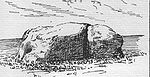 Few places have so many different names attached to them. One explanation is that the stone is 'Thor's Great Stone', another is that is "Thou Great Stone" or just '"grit stane", whilst 'The Stone of the Ogre' may reflect some forgotten legend of how the stone came to be in this position. Some names may be spelling errors perpetuated by or from Ordnance Survey and other maps. Another explanation of the name is that it is derived from 'Tagairtstane,' meaning the priest's stone. This 'Druidical' stone may have been a 'rocking or logan'
stone at one time, but it is now firmly set in the 'rubbish' and soil.
It is recorded that even as late as "the time of Popery" the devotees of that religion, in doing penance, used to crawl on their knees round this stone and cry, O thou grit stane from a belief that the Deity was in a peculiar manner present at that hallowed relic. Farmers from Brandleside Farm were bound to protect, by not removing it or ploughing within a set distance of the stone, possibly because of a tradition of pagan burials around this monument. Some recollections of May Day
events being held at the site are current and the site is listed and protected by Historic Scotland
. A fine view of Dunlop or Borland Hill, the site of Dunlop Castle once held by the De Ross family, can be seen from the stone.
is a parallel example to the Chapel Hill site at Chapeltoun
, where a Christian centre was established to supplant the pagan significance of the site. Monastic cells, a chapel and a graveyard are all lost to view, constructed by the monks of Kilwinning
, only the name 'Saint Mary's' given to the nearby 'modern' dwellings, built on the site of the chapel record past significance. Chapelhouse Farm is located beside the road nearby. The Holy Well still exists, the nearby houses pumping water up from its source. The water from the well used to run under the road and emerge in a trough surrounded by a metal fence. Only a concrete manhole indicates this trough now (2006). In 1856 the water for baptism in Dunlop Kirk was still drawn from this Holy Well.
 The small chapel had an endowment for the support of a chaplain. It was abandoned at the time of the Reformation in Scotland led by the ex-Roman Catholic priest John Knox
(1514 to 1572). The stones were robbed / mined by locals and the last remaining stones were taken away by a farmer in the 1830s. It stood on a rock from which a beautiful stream of water gushed into a small rivulet, this originally being crossed by steps, called the Lady's steps before the Chapelhouse Bridge was built. A carved relic of the old chapel, supposed to have been the font for holy water, was for some years used a trough for the pigs until it was finally broken up and used as building material. The Lady's Steps still existed in the late 1880s as they were on the path that ran from here to the Kirktoun of Dunlop Steps cut out of the rock face led up to the hill behind the chapel where the monk's graveyard was apparently located.
The 1858 OS map
locates the Lady's Steps near Hapland Mill on the Stewarton side of the town, crossing the Glazert
. Patterson and Bayne, both local people writing in 1866 and 1935 respectively, place the steps at Chapel Crags. The first Statistical Account of Ayrshire also places the steps at Chapel Crags. It seems odd to name these steps after a chapel that is a significant distance away in another valley; a cartographers error explains the situation as recorded in the first OS Name Book. A field near the 'Druid Stone' is called Templecroft and the first Celtic ‘Culdee
’ church may have been situated here, later replaced by the Roman Catholic Chapel. Ironically the pagan or Druidical stone is still there, but no sign of the Christian sites are visible, apart from the inconspicuous holy well in the field bordered by the burn.
 This Lea or Law hill, 687 ft (209.4 m) high, in the Lugton area of Dunlop Parish is supposed to be a 'moot' or trial hill. The arrangement of stones on its summit does not appear to be accidental and a grass covered cairn is very noticeable. A farmer from East Halket removed one of these to facilitate his ploughing. One stone on the summit has a vertical hole drilled to the depth of four feet or so, presumably to be used for ‘slot’ for a flagpole for flying a standard, a similar arrangement to that which existed at the Borestone at Greenhills
near Beith
. Near Aiket Castle
is another Court Hill. Halket is called Hawkhead by Thomson on his map of 1832. Halket Loch covered about 10 acres (40,468.6 m²) and was drained in the 1840s. It is shown on the early maps of Ayrshire.
may have existed here before the Reformation as suggested by the numerous placenames evidence, with Grangehill, Townhead of Grange, Mid Grange, South Grange, etc. A glebe field was also located here and an old drove road which ran passed Carswell Farm and up to Paisley.
Craignaught Hill lies in the north-east area of the Parish of Dunlop, the Clerkland Burn
running beneath and on to Dunlop House. On the lower slopes of Craignaught Hill was fought a singularly unusual battle between the Boyds of Kilmarnock and the Stewarts of Darnley
. Sir Alan Stewart had been treacherously slain by Sir Thomas Boyd; his son Alexander Stewart, was determined to take revenge.
Sir Thomas Boyd was surprised on the night of 9 July 1439, whilst riding past Craignaught on his way north and although outnumbered, he and his followers fought on, even taking agreed rest periods indicated by the sounding of a horn. The remaining Boyds placed themselves back to back, they closed up their ranks, and, forming a circle, they grimly set themselves to beat back the Stewarts or else die where they fought. Eventually and inevitably Sir Thomas Boyd was killed, whilst fighting Sir Alexander Stewart himself, stabbed in the back by a Stewart soldier, and a large number of his followers were also killed. The name is given as Sir Robert Boyd in at least one version of the tale.
The results of this encounter led to killings and counter killings which involved a great part of the West of Scotland. Boyd's wife had previously dreamed all of that which came to pass and died of grief within days of her husband death. The 1860 OS
marks 'Boyd's Hill' and 'Boyd's slack', Scots for a narrow pass, to the north of Craignaught on the old lane to Grange Farm, now named South Grange.
Boyd's Hill has been left undamaged (2007) by the quarrying and domestic waste disposal operations at Craignaught and the Boyd's slack is also clearly identifiable.
Prior to 1549 Hapland was part of the estate of Dunlop. David Dunlop exchanged or 'excambied' Hapland for the lands of Borland and in 1612 Patrick Cunninghame sold these lands to Gabriel Porterfield, son of Alexander Porterfield of that Ilk. Gabriel Porterfield of Porterfield in 1618 married Mariot Crawfurd and inherited the lands of Gills, Lothrihill, the Templeland and Maynes (Mains) of Hapland, including the mansion house. Gabriel Porterfield also took possession of Dunlop Hill, Wattirland (Waterland) and Halketh, with the loch (now drained). Dobie relates that On 31 May 1638, Gabriel Porterfield purchased from Neil Ryburn of that Ilk the 13s 4d. land of old extent of Ryburn, commonly called Temple-Ryburn. The estate of Hapland consisted of Brokwelmure (Brockwellmuir), Dunlophill-Montgomerie and Ryburn; later part of Lainshaw was purchased as well.
The Laird of Hapland was the ruling elder in the Parish of Dunlop in 1649 and was a captain in the Scots army when Cromwell was in Scotland, for which his lands were sequestrated. The last of the male line died when he fell off his horse when returning from Stewarton about 1765 or 1770. Lillias Porterfield married William Somerville of Kennox. Their youngest child, a daughter, married Colonel McAlester, Laird of Loup, in Kintyre
. A descendent built Chapelton
House near Stewarton. Hapland is near Dunlop. In 1820 the estate was of 200 acre (0.809372 km²) and the proprietor was Lieutenant-General Alexander Trotter. The old mansion house was demolished around 1876 as it was not in keeping with the modern age. A new steading was built at the site, possibly the 'Newhouse' marked on the OS maps. Some of the old tree wind-breaks and policies of the estate can still be made out. It seems likely that Temple-Ryburn had its name changed to Hapland at around this time as the OS of 1858 shows Ryburn in the same position as later maps (1897, etc.) show Hapland.
In 1820 Dunlop had only two people qualified to vote by right as freeholders.
A new gravitational water supply was opened for Dunlop in 1896, fed from a spring at Sidehead, the old water supply having been condemned.
Dunlop and Stewarton both stand on the old turnpike, completed from Glasgow by Lugton
, to Kilmarnock, Irvine and Ayr in 1820 at the cost of £18,000.
Dunlop Cattle are said to have originated within the parish, bred by Dunlop of that Ilk from improved stock from Holland in around 1550 to 1700 or later. The breed, also known as Cunninghame or Ayrshire cattle
are pied, white and brown, short in leg, long in the horn, straight in the back: the bulls are fiery in temper. The cows are peculiarly placid and docile, producing milk which is very high in butterfat
.
East Ayrshire
East Ayrshire is one of 32 council areas of Scotland. It borders on to North Ayrshire, East Renfrewshire, South Lanarkshire, South Ayrshire and Dumfries and Galloway...
, Scotland
Scotland
Scotland is a country that is part of the United Kingdom. Occupying the northern third of the island of Great Britain, it shares a border with England to the south and is bounded by the North Sea to the east, the Atlantic Ocean to the north and west, and the North Channel and Irish Sea to the...
. It lies on the A735, north-east of Stewarton
Stewarton
Stewarton is a town in East Ayrshire, Scotland. In comparison to the neighbouring towns of Kilmaurs, Fenwick, Dunlop and Lugton, it is a relatively large town, with a population of over 6,500. It is 300 feet above sea level.Groome, Francis H. . Ordnance Gazetteer of Scotland. Pub. Caxton. London....
, seven miles from Kilmarnock
Kilmarnock
Kilmarnock is a large burgh in East Ayrshire, Scotland, with a population of 44,734. It is the second largest town in Ayrshire. The River Irvine runs through its eastern section, and the Kilmarnock Water passes through it, giving rise to the name 'Bank Street'...
. The road runs on to Lugton
Lugton
Lugton is a small village or hamlet in East Ayrshire, Scotland with a population of 80 people. The A736 road runs through on its way from Glasgow, to the north, to Irvine in North Ayrshire. Uplawmoor is the first settlement on this 'Lochlibo Road' to the north and Burnhouse is to the south...
and the B706 enters the village from Beith
Beith
Beith is a small town situated in the Garnock Valley in North Ayrshire, Scotland approximately 20-miles south-west of Glasgow. The town is situated on the crest of a hill and was known originally as the "Hill o' Beith" after its Court Hill.-History:-Name:Beith's name is thought to emanate from...
.
The village
The name, first recorded in 1260, may be derived from the Gaelic words Dun - a castle and Luib - a bend. Therefore it is the fortified hill by the bend in the river. The old local pronunciation was Dulop or Delap without an 'n' and this has led to suggestions of other origins.Dunlop cheese
Dunlop cheese
Dunlop is a mild cheese or 'sweet-milk cheese' from Dunlop in East Ayrshire, Scotland. It resembles a soft Cheddar cheese in texture. It fell out of popularity some time after the end of the Second World War, however it has now appreciated for its value in various recipes and for eating on its own...
, a sweet milk cheese, was first made by Barbara Gilmour
Barbara Gilmour
Barbara Gilmour was a significant figure in 17th century Ayrshire having introduced a method of cheese making which became common throughout Ayrshire and beyond, providing employment and extra income for farmers and others...
who went to Ireland to escape the covenanting prosecutions. Her stone cheese press was said to be preserved at 'The Hill' Farm in the 1860s, but the existing press is dated after her death. The cheese became World famous and created a cottage industry with cheese merchants from Kirktoun buying up the cheeses and taking them to Glasgow for sale. The cheese making used up excess fresh milk and the coming of the railways reduced the need for cheese manufacture. Dunlop cheeses are still made at Clerkland Farm (2010).
Tam Giffen was reputed to be a warlock
Warlock
The term warlock in origin means "traitor, oathbreaker".In early modern Scots, the word came to be used as the male equivalent of witch ....
from the Dunlop Parish and many anecdotes are told of his marvellous doings in the 1860s. Tam could not get over the flood swollen Lugton Waster so he just ....came through below it. On another occasion he was prevented from helping the Devil blow a man off the thatched roof he was repairing by the man uttering God save me and had to make do with blowing off the man's wig and bonnet; finally he once entered a blacksnith's house by flying down the chimney. Tam died in odd circumstances, supposedly being murdered by the fairies
Fairy
A fairy is a type of mythical being or legendary creature, a form of spirit, often described as metaphysical, supernatural or preternatural.Fairies resemble various beings of other mythologies, though even folklore that uses the term...
for giving away their secrets.
In 1791 Dunlop is recorded as having six masons, twelve weavers, three smiths, three shoemakers, four tailors and three inn-keepers; by 1874 the village had 10 shoemakers, 8 masons, 6 weavers, 6 smiths, 5 wrights and 1 taylor, but no baker or flesher and the people's health was such that no surgeon was need or writer (lawyer). 1823 saw 'Mackie's Mill', producing woolen blankets, being set up on the banks of the Glazert Water and by 1939 Mackie's Mill was producing carpet yarn and had also branched out to establish two more manufacturing sites. In 1849 a Mr. Wilson set up shop as a ham curer. By the 1930s this ham curing business had diversified, and branched out into Ireland and had factories in Barrhead
Barrhead
Barrhead is a town in East Renfrewshire, Scotland, southwest of Glasgow on the edge of the Gleniffer Braes. As of the 2001 census its population was 19,813....
and at Eglinton
Eglinton Country Park
Eglinton Country Park is located in the grounds of the old Eglinton Castle estate, Kilwinning, North Ayrshire, Scotland . Eglinton Park is situated in the parish of Kilwinning, part of the former district of Cunninghame, and covers an area of 400 hectares...
in Irvine; the original curing house, known as the 'Burnhouse' has been landscaped and transformed into a local park thanks to funding from the Barcapel Foundation, previously the Clement Wilson Foundation. Robert Howie and sons started a small meal-mill in 1857, and then established a sawmill. They moved closer to the railway, where they remained until recently (2010).
The railway finally came to Dunlop in 1871 and because of the improved connection with Glasgow the farmers were able to send their milk directly into Glasgow, resulting in the decline and finally the cessation of cheese making in Dunlop. The population of the village in 1871 was 380 and 357 in 1881, whilst the parish was 1160 and 1361 persons respectively. In 1876 the town had acquired a butcher, a baker, a branch of the Clydesdale Bank
Clydesdale Bank
Clydesdale Bank is a commercial bank in Scotland, a subsidiary of the National Australia Bank Group. In Scotland, Clydesdale Bank is the third largest clearing bank, although it also retains a branch network in London and the north of England...
, as well as a Free Church (1845), but still no writer or doctor was needed. By the 1950s Dunlop had a post office, four grocers, a baker, a newsagent, a hotel, and a public House.
Dunlop's castles
Pont states that the ancient strong Dunlop Castle situated by the Clerkland Burn (NS 42737 49312) was protected by a moat or fosse of water and had 'goodly' orchards. Smith records that the 'Airn Yett
Yett
A yett is a gate or grille of latticed wrought iron bars used for defensive purposes in castles and tower houses...
' of the old castle was still preserved and its details published (see Wikimedia). It was also called Hunt Hall because the Dunlops were huntsmen to the De Ross family (Paterson 1866). The whole estate was sometimes referred to as Hunt Hall. This castle was situated at the site of the present day Dunlop House.
The De Ross family were vassals to the De Morvilles, Overlords of Cunninghame. The De Morvilles backed John Balliol's claim to the crown and forfeited their lands to the Boyds, and in 1570 the lands were held by the Cassillis family. In 1600 it is noted that David Dunlop of Hapland excambied
Excambion
-Definition:Excambion : The exchange of land. The deed whereby this is effected is termed "Contract of Excambion".There is an implied real warranty in this contract, so that if one portion is evicted or taken away on a superior title, the...
his lands with Patrick Cunninghame for his portion of the lands of Borland.
The native chiefs, although displaced from Boarland Hill do not appear to have been exiled, instead they established themselves at what is now Dunlop House. The name Boarland also survives in the names of Borlandhill, Over Borland, North Borland and Low Borland. The name Boarland could refer to the presence of wild boar, however a 'Boor' also meant a serf and Norman lords often apportioned lands near their castles for their servants. The Borland or Bordland also meant the land that was granted to the feudal superior specifically to be used to furnish food for his castle or dwelling.
There has been a modern day military use of Dunlop Hill, for in the 20th-century, between the two World Wars, a Royal Observer Corps
Royal Observer Corps
The Royal Observer Corps was a civil defence organisation operating in the United Kingdom between 29 October 1925 and 31 December 1995, when the Corps' civilian volunteers were stood down....
post was built into the west facing side of the hill. The personnel tracked enemy aircraft movement up the Clyde
Clyde
-Places named Clyde:In Scotland:* River Clyde* Firth of ClydeIn Australia:* Clyde, New South Wales* Clyde, Victoria* Clyde River, New South WalesIn Canada:* Clyde, Prince Edward Island* Clyde, Quebec* Clyde, Ontario* Clyde, Alberta...
towards Glasgow. Development of more sophisticated radar
Radar
Radar is an object-detection system which uses radio waves to determine the range, altitude, direction, or speed of objects. It can be used to detect aircraft, ships, spacecraft, guided missiles, motor vehicles, weather formations, and terrain. The radar dish or antenna transmits pulses of radio...
tracking techniques after World War 2 made the facility redundant.
The Dunlops of that Ilk
Kennox House
Kennox House is situated on the road from Stewarton to Torranyard in North Ayrshire, Parish of Dunlop, Scotland. The house overlooks the Glazert Water, which runs into the Annick Water at Watermeetings.-Crivoch House:...
.
Francis Dunlop was a witness to the disposition of the Scottish Regalia in Edinburgh Castle after the Union of the Crowns. James Dunlop of 1634-1670 married Elizabeth, daughter of Cunninghame of Corsehill and was an outstanding leader of the covenanters. John Dunlop 1748-1784 married the daughter of Sir Thomas Wallace of Craigie.
The last of the Dunlops to be born at Dunlop were John (1904) and Alexander (1906) Houison Crawfurd. Mrs Houison Crawfurd is remembered for producing the first tubercular-free cattle in Ayrshire. The house was let to a number of tenants, the Henderson family of the Anchor Line being the most notable. In 1933 the house was sold to Ayrshire County Council as a home for mentally defective children.
The Clerkland Burn rivulet runs past the Dunlop House mansion, forming the boundary between the parishes of Stewarton and Dunlop.
The Brechna Braes and Brackenheugh
The Brechna Braes area lies close to Dunlop and has been developed as the Templehouse Community Woodland to celebrate the 2000 Millennium. The Brackenheugh is a wooded slope overlooking Aiket CastleBarony of Aiket
The Barony of Aiket with its castle, lay within the old feudal bailiary of Cunninghame. The barony lands equate to the extant Parish of Dunlop, East Ayrshire, Scotland.-Aiket castle:...
. It is said to be the site of the death of one of the Cunninghames of Aiket, killed by a Montgomerie during the times of the feuds between these families.
Image:Braikenheuch cairn Dunlop.JPG|The cairn at the Dunlop Millennium Communiy Woodland
Image:Braikenheuch Hill Dunlop.JPG|A view of Braikenheugh Hill, the bridge, etc.
Image:Dunlop millennium community woodland.JPG|The view from the Templehouse woodland
File:The Braikenheugh from Aiket Castle..JPG|The Brackenheugh from Aiket Castle
Dunlop Church
In 1516 John Major or Mair, said to be the instructor of John KnoxJohn Knox
John Knox was a Scottish clergyman and a leader of the Protestant Reformation who brought reformation to the church in Scotland. He was educated at the University of St Andrews or possibly the University of Glasgow and was ordained to the Catholic priesthood in 1536...
held the post of vicar, mostly absentee as he was a professor of theology. By 1566 the vicar was was John Houston, who held the manse, garden and an acre of land adjoining the manse. The rest of the Kirkland-Dunlop lands passed from the Abbots of Kilwinning to William Cunninghame of Aiket and remained with the Cunninghames until the latter half of the 17th century. The Earl of Eglinton held the right of patronage when it was abolished in 1875.
Barbara Gilmour
Barbara Gilmour was a significant figure in 17th century Ayrshire having introduced a method of cheese making which became common throughout Ayrshire and beyond, providing employment and extra income for farmers and others...
, famous for introducing the production of Dunlop cheese
Dunlop cheese
Dunlop is a mild cheese or 'sweet-milk cheese' from Dunlop in East Ayrshire, Scotland. It resembles a soft Cheddar cheese in texture. It fell out of popularity some time after the end of the Second World War, however it has now appreciated for its value in various recipes and for eating on its own...
, is buried in the churchyard. Major McAlester of Kennox
Kennox House
Kennox House is situated on the road from Stewarton to Torranyard in North Ayrshire, Parish of Dunlop, Scotland. The house overlooks the Glazert Water, which runs into the Annick Water at Watermeetings.-Crivoch House:...
, then a heritor, obtained the 1792 bell and Miss McAlester and Charles G. S. McAlester returned it to the Kirk Session in 1935 to honour the centenary of the present church. son of Hans Hamilton, first Protestant minister of Dunlop Parish. In 1839 a new school was opened.
The Rev William Gebbie was the last minister to come into the parish under the old system of patronage, in this case that of the Earl of Eglinton
Earl of Eglinton
Earl of Eglinton is a title in the Peerage of Scotland.Some authorities spell the title: Earl of Eglintoun In 1859 the thirteenth Earl of Eglinton, Archibald Montgomerie, was also created Earl of Winton in the Peerage of the United Kingdom, which gave him an automatic seat in the House of Lords,...
. William was a fervent evangelist and the 'Dunlop Revival' shook the whole parish until the reverend was charged with heresy in the early 1860s. He remained as minister until 1883.
The old manse was sold and a new manse and offices were built by the heritors under the incumbency of Thomas Brisbane in 1781. This manse adjoined the 7 acres of the glebe and was extended by the Revd Dickie. The Kirktoun of Dunlop composed the manses and a row of cottages dated 1644, 1765, 1773, etc.
Hans Hamilton and the Picture House
John or Hans Hamilton (1535/6–1608), son of Archibald Hamilton of Raploch, was the first Protestant vicar and exhorter of Dunlop Church. One of his sons, James HamiltonJames Hamilton, 1st Viscount Claneboye
James Hamilton, 1st Viscount Claneboye was a Scot who became owner of large tracts of land in County Down, Ireland, and founded a successful Protestant Scots settlement there several years before the Plantation of Ulster...
was created Viscount Claneboye for his many services to James VI in establishing and maintaining Protestantism in Ireland
Ireland
Ireland is an island to the northwest of continental Europe. It is the third-largest island in Europe and the twentieth-largest island on Earth...
; his son James was in turn created Earl Clanbrassil
Earl of Clanbrassil
The title of Earl of Clanbrassil was created twice in the Peerage of Ireland.On 4 May 1622 Sir James Hamilton was created Viscount Claneboye in the Peerage of Ireland. The 2nd Viscount, of the same name, was created Earl of Clanbrassil on 7 June 1647...
by Charles I. His five brothers also established estates in Ireland. A handsome mausoleum (NS 40486 49398) was constructed over their graves by James in 1641, when he was in his eighties, and this was so ornately painted and gilded in the Roman Catholic manner that it attracted the sobriquet of 'The Picture House'. The flat tombstone of Hans Hamilton was originally on the floor, but this was later removed and placed on the south wall. It was much neglected and vandalised even in 1699, but in 1734 it was given some much needed repairs. Around 1849 Colonel Mure of Caldwell had further repairs carried out. The marble statues of Hans and his wife have now been removed to a place of safety for their protection (2005).
Jean Hamilton, the daughter of Hans Hamilton, had a dowary of 5000 merks in 1613.
Clandeboye school
Viscount Claneboye also built and invested a school, now known as Clandeboye Hall (Claneboye in his title was spelt differently from the placename Clandeboye) and used by the church for events. Carved above the door was the date 1641 with the statement This school is erected and endowed by Iames Clandeboyes, in love to this parish in which his father Hans Hamilton was pastor 45 years in King Iames the sixt his raigne. The carving was removed when the school was sold as a private dwelling. The school had been condemned by 1876 and was in use as a shoemaker's shop and a dwelling.Aiket Castle
Aiket Castle itself was originally a square tower typical of the residences of the lesser feudal Norman barons, originally surrounded by a moat. The name is derived from 'Oak Wood'. The family were descended from the Cunninghames of Bedland, who were cadets of the family of Glencairn. Alexander Cunninghame is the first recorded as living at Aiket. Three Aiket daughters were married to participants in the tale of the murder of the 4th Earl of Eglinton.'
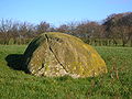
The Carlin Stone or Hag Stone
On top of the Commoncraigs or Common Crags overlooking Dunlop and the Glazert is a large procumbent boulder known on the OS map as the ‘Carlin’s Stone or Stane’. A Carl is a commoner, a husband or in a derogatory sense, a churlChurl
A churl , in its earliest Old English meaning, was simply "a man", but the word soon came to mean "a non-servile peasant", still spelt ċeorl, and denoting the lowest rank of freemen...
or male of low birth. More commonly the name Carlin was used as a derogatory term for a woman meaning an 'old hag'. It is also said to be a corruption or Scots equivalent of the Gaelic word “Cailleach
Cailleach
In Irish and Scottish mythology, the , also known as the Cailleach Bheur, is a divine hag, a creatrix, and possibly an ancestral deity or deified ancestor...
”, meaning a witch or the 'old Hag', the Goddess of Winter. This would therefore be the Witch’s or Hag's Stone, one of several in Scotland with this name.
Image:Carlinstone.jpg|A view of the Carlin Stone
Image:Carlin stone dunlop.JPG|The Carlin stone from the Commoncraigs Community Woodland
Image:Carlin stone dunlop two.JPG|Illustrating the procumbent position of the stone
Near Kirkhill outside Stewarton
Stewarton
Stewarton is a town in East Ayrshire, Scotland. In comparison to the neighbouring towns of Kilmaurs, Fenwick, Dunlop and Lugton, it is a relatively large town, with a population of over 6,500. It is 300 feet above sea level.Groome, Francis H. . Ordnance Gazetteer of Scotland. Pub. Caxton. London....
are several farms having the name 'Kilbride' in their title. Bride - an anglicization of Brìghde
Brigid
In Irish mythology, Brigit or Brighid was the daughter of the Dagda and one of the Tuatha Dé Danann. She was the wife of Bres of the Fomorians, with whom she had a son, Ruadán....
, Brìd or Saint Brigid
Brigid of Kildare
Saint Brigit of Kildare, or Brigit of Ireland , nicknamed Mary of the Gael is one of Ireland's patron saints along with Saints Patrick and Columba...
- was originally the Celtic Goddess linked with the festival of Imbolc
Imbolc
Imbolc , or St Brigid’s Day , is an Irish festival marking the beginning of spring. Most commonly it is celebrated on 1 or 2 February in the northern hemisphere and 1 August in the southern hemisphere...
, the eve of the first of February. Carlin's Tooth is the name of a rock outcrop in the borders between Knocks Knowe and Carter Fell. Three farms named 'Carlingcrags' are to be found above Darvel in East Ayrshire.
The Thurgatstane or Ogrestane
Thurgartstone
The Thurgatstane or Ogrestane is a famous stone near Dunlop in East Ayrshire in Scotland. The Thurgatsane is thought to have been a rocking stone at one time, but it no longer rocks.-Name:...
is just outside of Dunlop on the Lugton Road in the valley of the Black Burn. It is in a sheltered spot, with ample running water and well hidden from immediate view. In the middle of a field near the Chapel Crags is the Thurgatstane or Ogrestane, also known as the Thorgatstane, Field Spirit Stane, T'Ogra Stane, Thugart Stane, Ogirtstane, Ogart stane, Horgar Stane, Fiend's Stane or Thougritstane. It is a glacial erratic stone, composed of blue augitic porphyrite and is quite unlike the 'native' stone of the district, weighing about 25 tons and measuring about twelve feet by eight feet as measured above ground. It is set near the site of the pre-reformation St.Mary's Chapel and has long been associated with pagan ritual practices.
Rocking stone
Rocking stones are large stones that are so finely balanced that the application of just a small force causes them to rock. They are found throughout the world. Some are man-made megaliths, but others are natural, often left by glaciers.Logan or rocking stones are known in Scotland sometimes as...
stone at one time, but it is now firmly set in the 'rubbish' and soil.
It is recorded that even as late as "the time of Popery" the devotees of that religion, in doing penance, used to crawl on their knees round this stone and cry, O thou grit stane from a belief that the Deity was in a peculiar manner present at that hallowed relic. Farmers from Brandleside Farm were bound to protect, by not removing it or ploughing within a set distance of the stone, possibly because of a tradition of pagan burials around this monument. Some recollections of May Day
May Day
May Day on May 1 is an ancient northern hemisphere spring festival and usually a public holiday; it is also a traditional spring holiday in many cultures....
events being held at the site are current and the site is listed and protected by Historic Scotland
Historic Scotland
Historic Scotland is an executive agency of the Scottish Government, responsible for historic monuments in Scotland.-Role:As its website states:...
. A fine view of Dunlop or Borland Hill, the site of Dunlop Castle once held by the De Ross family, can be seen from the stone.
The Monastic Settlement
The history of the monastic settlement and the chapel of Saint Mary (NS 4080 5032) at the ThurgartstoneThurgartstone
The Thurgatstane or Ogrestane is a famous stone near Dunlop in East Ayrshire in Scotland. The Thurgatsane is thought to have been a rocking stone at one time, but it no longer rocks.-Name:...
is a parallel example to the Chapel Hill site at Chapeltoun
Chapeltoun
Chapeltoun is an estate on the banks of the Annick Water in East Ayrshire, Scotland. This is a rural area famous for its milk and cheese production and the Ayrshire or Dunlop breed of cattle.-Templeton and the Knights Templar:...
, where a Christian centre was established to supplant the pagan significance of the site. Monastic cells, a chapel and a graveyard are all lost to view, constructed by the monks of Kilwinning
Kilwinning
Kilwinning is a historic town in North Ayrshire, Scotland. It is known as The Crossroads of Ayrshire. The 2001 Census recorded it as having a population of 15,908.-History:...
, only the name 'Saint Mary's' given to the nearby 'modern' dwellings, built on the site of the chapel record past significance. Chapelhouse Farm is located beside the road nearby. The Holy Well still exists, the nearby houses pumping water up from its source. The water from the well used to run under the road and emerge in a trough surrounded by a metal fence. Only a concrete manhole indicates this trough now (2006). In 1856 the water for baptism in Dunlop Kirk was still drawn from this Holy Well.
John Knox
John Knox was a Scottish clergyman and a leader of the Protestant Reformation who brought reformation to the church in Scotland. He was educated at the University of St Andrews or possibly the University of Glasgow and was ordained to the Catholic priesthood in 1536...
(1514 to 1572). The stones were robbed / mined by locals and the last remaining stones were taken away by a farmer in the 1830s. It stood on a rock from which a beautiful stream of water gushed into a small rivulet, this originally being crossed by steps, called the Lady's steps before the Chapelhouse Bridge was built. A carved relic of the old chapel, supposed to have been the font for holy water, was for some years used a trough for the pigs until it was finally broken up and used as building material. The Lady's Steps still existed in the late 1880s as they were on the path that ran from here to the Kirktoun of Dunlop Steps cut out of the rock face led up to the hill behind the chapel where the monk's graveyard was apparently located.
The 1858 OS map
Ordnance Survey
Ordnance Survey , an executive agency and non-ministerial government department of the Government of the United Kingdom, is the national mapping agency for Great Britain, producing maps of Great Britain , and one of the world's largest producers of maps.The name reflects its creation together with...
locates the Lady's Steps near Hapland Mill on the Stewarton side of the town, crossing the Glazert
River Irvine
The River Irvine is a river flowing through southwest Scotland, with its watershed on the Lanarkshire border of Ayrshire at an altitude of above sea-level, near Drumclog, and SW by W of Strathaven...
. Patterson and Bayne, both local people writing in 1866 and 1935 respectively, place the steps at Chapel Crags. The first Statistical Account of Ayrshire also places the steps at Chapel Crags. It seems odd to name these steps after a chapel that is a significant distance away in another valley; a cartographers error explains the situation as recorded in the first OS Name Book. A field near the 'Druid Stone' is called Templecroft and the first Celtic ‘Culdee
Culdee
Céli Dé or Culdees were originally members of ascetic Christian monastic and eremitical communities of Ireland, Scotland and England in the Middle Ages. The term is used of St. John the Apostle, of a missioner from abroad recorded in the Annals of the Four Masters at the year 806, and of Óengus...
’ church may have been situated here, later replaced by the Roman Catholic Chapel. Ironically the pagan or Druidical stone is still there, but no sign of the Christian sites are visible, apart from the inconspicuous holy well in the field bordered by the burn.
Craighead Law Hill
Barony and Castle of Giffen
The Barony of Giffen and its associated 15th-century castle were in the parish of Beith in the former District of Cunninghame, now North Ayrshire. The site may be spelled Giffen or Giffin and lay within the Lordship of Giffin, which included the Baronies of Giffen, Trearne, Hessilhead, Broadstone,...
near Beith
Beith
Beith is a small town situated in the Garnock Valley in North Ayrshire, Scotland approximately 20-miles south-west of Glasgow. The town is situated on the crest of a hill and was known originally as the "Hill o' Beith" after its Court Hill.-History:-Name:Beith's name is thought to emanate from...
. Near Aiket Castle
Barony of Aiket
The Barony of Aiket with its castle, lay within the old feudal bailiary of Cunninghame. The barony lands equate to the extant Parish of Dunlop, East Ayrshire, Scotland.-Aiket castle:...
is another Court Hill. Halket is called Hawkhead by Thomson on his map of 1832. Halket Loch covered about 10 acres (40,468.6 m²) and was drained in the 1840s. It is shown on the early maps of Ayrshire.
Grange
A monastic Grange, probably belonging to Kilwinning AbbeyKilwinning Abbey
Kilwinning Abbey is a ruined abbey located in the centre of the town of Kilwinning, North Ayrshire.-The establishment of the Abbey:The ancient name of the town is 'Segdoune' or 'Saigtown', probably derived from 'Sanctoun', meaning the 'town of the saint'. Saint Winnings festival was on 21 January...
may have existed here before the Reformation as suggested by the numerous placenames evidence, with Grangehill, Townhead of Grange, Mid Grange, South Grange, etc. A glebe field was also located here and an old drove road which ran passed Carswell Farm and up to Paisley.
The Battle of Boyd's or Craignaught Hill
| Etymology |
| The name 'Craignaught' is derived fron the Gaelic words 'Craig' (Rock) and 'Nochdta' (Naked), together literally mean 'Bare Rock' hill. Also recorded as Craighnaucht or Craignaugh. |
Craignaught Hill lies in the north-east area of the Parish of Dunlop, the Clerkland Burn
River Irvine
The River Irvine is a river flowing through southwest Scotland, with its watershed on the Lanarkshire border of Ayrshire at an altitude of above sea-level, near Drumclog, and SW by W of Strathaven...
running beneath and on to Dunlop House. On the lower slopes of Craignaught Hill was fought a singularly unusual battle between the Boyds of Kilmarnock and the Stewarts of Darnley
Darnley
Darnley is an area in south-west Glasgow, Scotland located on the A727 just west of Arden. During the second half of the 20th Century Darnley has experienced total transformation from being a modest semi-rural community to becoming a significant part of Glasgow's response to a post-war housing...
. Sir Alan Stewart had been treacherously slain by Sir Thomas Boyd; his son Alexander Stewart, was determined to take revenge.
Sir Thomas Boyd was surprised on the night of 9 July 1439, whilst riding past Craignaught on his way north and although outnumbered, he and his followers fought on, even taking agreed rest periods indicated by the sounding of a horn. The remaining Boyds placed themselves back to back, they closed up their ranks, and, forming a circle, they grimly set themselves to beat back the Stewarts or else die where they fought. Eventually and inevitably Sir Thomas Boyd was killed, whilst fighting Sir Alexander Stewart himself, stabbed in the back by a Stewart soldier, and a large number of his followers were also killed. The name is given as Sir Robert Boyd in at least one version of the tale.
The results of this encounter led to killings and counter killings which involved a great part of the West of Scotland. Boyd's wife had previously dreamed all of that which came to pass and died of grief within days of her husband death. The 1860 OS
Ordnance Survey
Ordnance Survey , an executive agency and non-ministerial government department of the Government of the United Kingdom, is the national mapping agency for Great Britain, producing maps of Great Britain , and one of the world's largest producers of maps.The name reflects its creation together with...
marks 'Boyd's Hill' and 'Boyd's slack', Scots for a narrow pass, to the north of Craignaught on the old lane to Grange Farm, now named South Grange.
Boyd's Hill has been left undamaged (2007) by the quarrying and domestic waste disposal operations at Craignaught and the Boyd's slack is also clearly identifiable.
The Gemmells of Templehouse
The Knights Templar are remembered in the name of this property, which since 1570 was in the hands of the Gemmill or Gemmell family. In 1596 Patrick Gemmill resigned the Templelands of Dunlop Hill into the hands of the Superior, Lord Torphichen, in favour of his eldest son. The Sandilands, Lords Torphichen are remembered elsewhere, such as Sandilands Farm near Kennox, although the farm name has now been changed to Bankend. The Gemmells still held Templehouse in the 1860s.The Lands of Hapland
| Etymology |
| The name may be a corruption of 'Whaup Land'; a 'whaup' being Scots for a curlew Curlew The curlews , genus Numenius, are a group of eight species of birds, characterised by long, slender, downcurved bills and mottled brown plumage. They are one of the most ancient lineages of scolopacid waders, together with the godwits which look similar but have straight bills... . |
Prior to 1549 Hapland was part of the estate of Dunlop. David Dunlop exchanged or 'excambied' Hapland for the lands of Borland and in 1612 Patrick Cunninghame sold these lands to Gabriel Porterfield, son of Alexander Porterfield of that Ilk. Gabriel Porterfield of Porterfield in 1618 married Mariot Crawfurd and inherited the lands of Gills, Lothrihill, the Templeland and Maynes (Mains) of Hapland, including the mansion house. Gabriel Porterfield also took possession of Dunlop Hill, Wattirland (Waterland) and Halketh, with the loch (now drained). Dobie relates that On 31 May 1638, Gabriel Porterfield purchased from Neil Ryburn of that Ilk the 13s 4d. land of old extent of Ryburn, commonly called Temple-Ryburn. The estate of Hapland consisted of Brokwelmure (Brockwellmuir), Dunlophill-Montgomerie and Ryburn; later part of Lainshaw was purchased as well.
The Laird of Hapland was the ruling elder in the Parish of Dunlop in 1649 and was a captain in the Scots army when Cromwell was in Scotland, for which his lands were sequestrated. The last of the male line died when he fell off his horse when returning from Stewarton about 1765 or 1770. Lillias Porterfield married William Somerville of Kennox. Their youngest child, a daughter, married Colonel McAlester, Laird of Loup, in Kintyre
Kintyre
Kintyre is a peninsula in western Scotland, in the southwest of Argyll and Bute. The region stretches approximately 30 miles , from the Mull of Kintyre in the south, to East Loch Tarbert in the north...
. A descendent built Chapelton
Chapeltoun
Chapeltoun is an estate on the banks of the Annick Water in East Ayrshire, Scotland. This is a rural area famous for its milk and cheese production and the Ayrshire or Dunlop breed of cattle.-Templeton and the Knights Templar:...
House near Stewarton. Hapland is near Dunlop. In 1820 the estate was of 200 acre (0.809372 km²) and the proprietor was Lieutenant-General Alexander Trotter. The old mansion house was demolished around 1876 as it was not in keeping with the modern age. A new steading was built at the site, possibly the 'Newhouse' marked on the OS maps. Some of the old tree wind-breaks and policies of the estate can still be made out. It seems likely that Temple-Ryburn had its name changed to Hapland at around this time as the OS of 1858 shows Ryburn in the same position as later maps (1897, etc.) show Hapland.
Micro-history
Dunlop had a cricket club near Mains of Aiket beside the railway.In 1820 Dunlop had only two people qualified to vote by right as freeholders.
A new gravitational water supply was opened for Dunlop in 1896, fed from a spring at Sidehead, the old water supply having been condemned.
Dunlop and Stewarton both stand on the old turnpike, completed from Glasgow by Lugton
Lugton
Lugton is a small village or hamlet in East Ayrshire, Scotland with a population of 80 people. The A736 road runs through on its way from Glasgow, to the north, to Irvine in North Ayrshire. Uplawmoor is the first settlement on this 'Lochlibo Road' to the north and Burnhouse is to the south...
, to Kilmarnock, Irvine and Ayr in 1820 at the cost of £18,000.
Dunlop Cattle are said to have originated within the parish, bred by Dunlop of that Ilk from improved stock from Holland in around 1550 to 1700 or later. The breed, also known as Cunninghame or Ayrshire cattle
Ayrshire cattle
The Ayrshire cattle is a breed of dairy cattle originated from Ayrshire in Scotland. The average mature Ayrshire cow weighs 1,000-1,300 pounds . Ayrshires have red markings. The red can be an orange to a dark brown, with or without coloured legs. They are known for low somatic cell counts,...
are pied, white and brown, short in leg, long in the horn, straight in the back: the bulls are fiery in temper. The cows are peculiarly placid and docile, producing milk which is very high in butterfat
Butterfat
Butterfat or milkfat is the fatty portion of milk. Milk and cream are often sold according to the amount of butterfat they contain.- Composition :The fatty acids of butterfat are typically composed as follows :...
.
See also
- Barony of AiketBarony of AiketThe Barony of Aiket with its castle, lay within the old feudal bailiary of Cunninghame. The barony lands equate to the extant Parish of Dunlop, East Ayrshire, Scotland.-Aiket castle:...
- StewartonStewartonStewarton is a town in East Ayrshire, Scotland. In comparison to the neighbouring towns of Kilmaurs, Fenwick, Dunlop and Lugton, it is a relatively large town, with a population of over 6,500. It is 300 feet above sea level.Groome, Francis H. . Ordnance Gazetteer of Scotland. Pub. Caxton. London....
- Castle and Barony of RobertlandCastle and Barony of RobertlandThe Castle and Barony of Robertland is located near Stewarton, off the B769 road, in the old district of Cunninghame, Parish of Stewarton, and now part of East Ayrshire, Scotland.-Robertland castle and barony:...
- Dunlop railway stationDunlop railway stationDunlop railway station serves the village of Dunlop in East Ayrshire, Scotland. The station is managed by First ScotRail and is on the Glasgow South Western Line.- History :...