

Benslie
Encyclopedia
Benslie is a small village in North Ayrshire
, in the parish of Kilwinning
, Scotland
. Map reference NS 336 429.
1604 - 08), Bainsley in 1821 (John Ainslie's map), Bensley (Groome 1903), Benslee or Benslee square on the 1860 OS map, Bendslee is situated next to Benslie wood. The village sits on the B 785 Fergushill Road and on the junction of the road to Montgreenan
and Torranyard
on the Lochlibo Road. The OS maps show that it was named 'Montgreenan' up until at least 1938, with the name Benslie given to the wood, the old farmhouse on the 'island' created by the three roads and the term Benslie Square. A Mission hall is marked as being at Benslie square on the 1910 OS map. The postal address may have been the direct cause of the name change, preventing confusion with the nearby Montgreenan estate.
Some dwellings were also present at Rosebank or Woodneuk (1858 OS map), situated just before the bridge that crossed the railway at Montgreenan station
. A small mine was developed here and only a brick tower and bing remain in 2007. The village had a small Church hall which was used for indoor bowls and other activities. This building was demolished in 1993 and was replaced by a house named Kinnoull, a new family to the village moved into the house in 1994. A tennis court also existed at one time, next to the church hall. A number of new houses have been constructed since 1990; transforming the size and nature of this rural settlement.
A Chapel Hill cottage existed at one time, suggesting that the chapel existed on the 'hill', possibly within what is now Benslie Wood. A small mound existed in the wood near Wood Neuk Cottage, but this may have been removed during the building of the new houses. The 1774 Ayr Roads Act names a Corsehill Chapel on the Toll Road from Kilwinning to Dreghorn via Milnburn. A statement to the effect that a chapel existed in the middle of the 'feature;' has been made, however details are lacking. There is a Lady Acre on the lands of Corsehill.
The local farms include Benslie Fauld, as well as North and South Millburn. A lane connected Laigh Patterton Farm with the old Netherfield farm and Benslie . The exit is preserved between the two modern buildings, Benslie House and Kinnoull, near the old fireclay mine.
Robert Aitken's 1823 map of The Parishes of Ardrossan, Stevenston and Kilwinning shows a Backmossfauld farm near the old Netherfield farm. This map also gives East Doura as the name of the farm which was later known as South Millburn.
Image:Benslie village from Fergushill.JPG|The village from the Fergushill side. Note Benslie Cottage and Roberton in the background.
Image:The Benslie Cottage.JPG|Benslie cottage, a n old farm steading, from which the village took its 'modern' name.
Image:Benslie cottages.JPG|'Roberton' and another old Cottage, Woodside, which previously served as the village Post Office.
Image:Benslie mine owners cottage.JPG|The old mine manager's house. A mound extends into this house's garden.
of the late 20th-century. Benslie itself was made up of 57 stone built miners houses, owned by A. Finnie and Son. Coalmasters. In 1913 the village was said to be 67 years old. The population was 318 in 1881. At first the houses only existed at the 'Square' and then later the village was extended towards the road which runs up passed the church. A number of coal pits were in the area as shown by the first edition OS map, one pit being close to the 'Millburn Cottage' opposite South Millburn. In 1937 most of the miner's rows were demolished and the miners were moved to the Dirrans.
. This is not as unlikely as it seems because the mining methods of the time had exhausted the available coal stocks and that their existed an "exhorbitant dearth and scantness of fewale within the Realme." He was the doctor for the pit and recalls that when the pit was drained, William Ralston, the ganger, found the old workmens tools and their bones at the coal face.
In Duguid's time another disaster took place after heavy frosts had loosened the pit soil and the pit supports gave way. Pate Brogildy from the Redboiler survived, however he later had his arm ripped off at the shoulder blade by the fly-wheel of the pit steam engine. He survived as the twisting motion of the 'amputation' had sealed the arteries. Willie Forgisal (Fergushill?) of Torranyard had his leg amputated above the knee. James Jamphrey from Corsehill was killed instantly.
The Statistical Account records that the coals at Doura were ell and stone-coals. Easter Doura mine employed 12 - 16 colliers and was owned by Lord Lisle and was leased by him for £140 per annum in the 18th century.
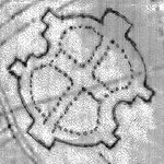
' or 'Celtic Cross' feature is what is now known as Benslie Wood, part of the extensive Eglinton Castle historic landscape, located outside of the formal 'Pleasure Gardens' on Benslie farm. Much of this landscape feature's outline survives except on the Benslie village side of the present wood, with the present road cutting through the extreme edge of the feature. The 'outline' is formed from linear earth banks which contain a quantity of stone and shows signs of being originally planted up with beech and sycamore trees as evidenced from the remains of old tree stumps or surviving old tree specimens. With no evidence of a boundary wall, it is possible that a pale existed to make the enclosure stockproof. The linear bank is mostly curved, except for short sections where 'right angle' bends were required to form the desired 'baroque' shape. It may have had a pale or fence on top of it to make it stockproof, in addition to the boundary ditch.
Skill would have been necessary to accurately lay out this complex shape. A cross-shape and peripheral 'path' network appears to have been created of which no definite sign remains. The extensive earth movements associated with the 'rig and furrow' works appear to pre-date the feature, the same works being visible in the surrounding fields as well. The position of the older holly trees is suggestive of their being in lines as if they are the remains of an internal 'hedge' planting. These old holly trees were a feature of the wood as far back as the 1930s. Rackham has shown that holly trees can live for three to four hundred years and therefore the old hollies could date from 1747. A few show clear signs of long predating the birch trees, their present stunted growth only occurring once the birch trees were mature and cast significant shade. Holly is fairly resistant to cattle and deer, indeed it was deliberately planted because its foliage was cut as iron rations for deer and other stock in winter.
The 1747 Roy's map is a 'snapshot' in time and does not necessarily represent the completed feature. It does not appear as an extension of the extensive Eglinton 'pleasure gardens', however it does appear to align with the large rond-point still known as 'The Circle'. As a feature it is unlikely that the entire 'baroque' shape could be seen from any nearby location, but it may have been discernible from the upper areas of the castle. The original feature appears to have had open launds, delineated by sycamore and beech planting on the outer boundary and possibly the aforementioned holly planting in the interior.
In 1775 Andrew Armstrong's, A new map of Ayrshire... shows a circular woodland on the borders of the Doura estate, open apart from what appears to be a single tree in its centre.
 The name 'fauld' may hold a clue to the purpose or use of this landscape feature as this is Scots
for an area manured by sheep, cattle or possibly deer. At this time the main estate 'pleasure gardens' did not include a deer park.
The present wood is largely composed of Silver Birch
trees which have grown naturally. The wood was felled in the 1940s by a foundry owner in Kilwinning and the ground was regularly burned until about forty years ago to keep it clear of brambles, trees, etc. Downy birch
, oak, sycamore and willow are also present. An unusually predominant presence of holly
trees, especially old holly trees, has already been remarked upon and may reflect a feature of the planting of the original 'Baroque
' feature.
The 'Baroque' or 'Celtic cross' layout is said to be similar to that which existed at the Optagon Park, Alloa
Estate, Clackmannanshire; which in turn was modelled after the Dutch taste and based upon Hampton Court, the favourite home of King William
; a Dutchman. It is possible that this area was incomplete when mapped by Roy in the 1750s.
Mr. Robert McGill of North Millburn Farm recalls that local lore has it that after a 'plague' in the 19th-century a large number of people from the local miner's rows were buried in a mass grave in Benslie Wood. Another local tradition is that the bodies were buried in the nether fields of Soth Millburn, close to the old Doura coal pit.
The wood was created on the lands of the old Benslie farm, however a small wood existed before and a remnant of this wood survived until recently in the area now occupied by Benslie House and Kinnouli. John Thomson's Atlas of Scotland, 1832, shows Benslie Wood, bisected by a road, but without the characteristic shape.
, to Benslie Fauld. Wullie was given a bowl of brose by the farmer's wife and whilst saying grace he decided that the servant girl was being less than generous with the milk, so he said between his clasped fingers, Ay, noo, Jean, juist pour't a' on your wa's!
Image:Benslie Wood.JPG|Benslie wood on the site of the old Baroque
feature.
Image:Benslie Wood baroque 1.JPG|The 'park' outline where it diverges from the hedge bordering Fergushill Road.
Image:Benslie Wood baroque 2.JPG|A 'right angle' turn on the 'Doura' side of the wood.
Image:Benslie Wood baroque 3.JPG|A double 'right angle' turn on the 'Doura' side of the wood.
Image:Benslie Wood birch holy.JPG|A view in the wood with birch and holly on the well preserved rigs and furrows.
Image:Benslie Wood birches.JPG|A view of the 'rig & furrow' style drainage and the dominant planted birch composition of the woodland.
usually existed within each barony in feudal times, such as the surviving 'Court Hill' near Beith
and the now destroyed example at Greenhills near Barmill in the Barony of Giffen
. Fergushill
was a barony, as was Montgreenan. It is not known where the moot hills were for these. A fair sized mound is shown on several OS maps
as existing within Benslie Wood close behind Wood Neuk cottage and therefore to the rear of the modern houses facing onto the road to Montgreenan.
The purpose of this mound is unknown, however it would have been a prominent feature if the hill was not afforested and it could have served as the moot hill for the barony or it may be a plausible candidate for the site of the old chapel.
An irregularly shaped raised area of ground runs down from near Benslie Fauld farm into the garden of Wood Neuk.
, and Montgreenan . It was consecrated on Sunday, 3 November 1879 and the first minister was then Rev. William McAlpine. It got its name from the Fergushill Mission which was based at Fergushill school which had closed in 1950. The old school master's house (See photograph) is still in existence at the junction of the road to Seven Acres Mill. The church had its spire blown down in a gale in 1968, also damaging the roof; the building was repaired in 1969. The Church of Scotland Presbytery of Ardrossan decided to close the church in June 2009; over a hundred people attended the final Sunday service.
The manse, later named 'Janburrow' is now a private house and stands at the entrance to the old Montgreenan railway station
drive. Janbarrow first belonged to Mr. James Watson, a local joiner and was purchased by the G&SWR
for its agent at Montgreenan station in 1884 at the cost of £255. The house was purchased from the railway by Mr. Currie of Hurlford and later purchased by the church in 1906 when an extra bay was added. Opposite is Burnbrae cottage, built as the Montgreenan Estate factor's house in 1846. 'Janburrow' is derived from the lady named Janet who came from Burrowland farm and lived in the old manse for many years after a Mrs Reid, the previous owner, had died.
Image:Fergushillbenslie.JPG|Fergushill church at Benslie.
Image:Fergushill church interior.JPG|The interior.
Image:Wm MacAlpine Fergushill.JPG|Memorial to William MacAlpin
Image:Fergushill manse.JPG|Janburrow, Fergushill church's old manse and previously the G&SWR company agent's office near Montgreenan.
 Doura Hall was a 17th-century building located on the road up to Doura Mains farm. It had been the intention of the Lairds of Corsehill to build a new house at the 'Dowrie' in the Barony of Dowra, however nothing was done, but plans of the proposed buildings have survived. It was lived in by Sir Walter Montgomerie-Cunninghame in the 1780s after he lost Lainshaw House. James Boswell described it as a poor building. It was demolished in the 19th-century and appeared on the 1910 25 inches (635 mm) to the mile OS map. A Dovecote hill and orchard brae are further reminders of this estate, owned by the Cunninghames of Corsehill. South Millburn is marked as East Doura on the 1910 OS map. A smithy was located at the Doura hamlet in the late 18th-century.
In 1691 the Hearth Tax records show that the hall had six hearths and was occupied by Lady Corshill. The barony had sixteen other dwellings.
In 1775 Andrew Armstrong's, A new map of Ayrshire... shows the 'Dowrey' mansion house and wooded policies of Doura. John Ainslie's 1821 Map of the Southern Part of Scotland uses the name 'Dourey'.
in 1832 and Scarlet fever
in 1837. Sentinels were placed at points on the roads to stop anyone entering or leaving the effected areas.
The name 'Benslie' exists as a surname. It is not known if any connection exists with the village.
The British Telecom 2006/7 'Phone Book' has Benslie with the spelling 'Bensley' and even Bensley Cottage (Sic) is recorded as being in Montgreenan.
Houses existed at the end of Millburn Drive and mid-way along. On the left when facing Millburn Lodge; where it joins Fergushill Road, was the railway hut used by the railway employee who controlled the level crossing gates which permitted freight trains to cross the drive.
A rare visitor, the Ivory Gull
, was photographed at Laigh Patterton Farm, in Jan 2007.
North Ayrshire
North Ayrshire is one of 32 council areas in Scotland with a population of roughly 136,000 people. It is located in the south-west region of Scotland, and borders the areas of Inverclyde to the north, Renfrewshire to the north-east and East Ayrshire and South Ayrshire to the East and South...
, in the parish of Kilwinning
Kilwinning
Kilwinning is a historic town in North Ayrshire, Scotland. It is known as The Crossroads of Ayrshire. The 2001 Census recorded it as having a population of 15,908.-History:...
, Scotland
Scotland
Scotland is a country that is part of the United Kingdom. Occupying the northern third of the island of Great Britain, it shares a border with England to the south and is bounded by the North Sea to the east, the Atlantic Ocean to the north and west, and the North Channel and Irish Sea to the...
. Map reference NS 336 429.
History
This village, previously Benislay (1205), Beinslay (Timothy PontTimothy Pont
Timothy Pont was a Scottish topographer, the first to produce a detailed map of Scotland. Pont's maps are among the earliest surviving to show a European country in minute detail, from an actual survey.-Life:...
1604 - 08), Bainsley in 1821 (John Ainslie's map), Bensley (Groome 1903), Benslee or Benslee square on the 1860 OS map, Bendslee is situated next to Benslie wood. The village sits on the B 785 Fergushill Road and on the junction of the road to Montgreenan
The Lands of Montgreenan
Montgreenan is an estate in North Ayrshire, Parish of Kilwinning, Scotland. The Lugton Water runs through the policies and farmland of Montgreenan...
and Torranyard
Auchenharvie Castle
Auchenharvie Castle is a ruined castle near Torranyard on the A 736 Glasgow to Irvine road. It lies in North Ayrshire, Scotland.-The Castle:...
on the Lochlibo Road. The OS maps show that it was named 'Montgreenan' up until at least 1938, with the name Benslie given to the wood, the old farmhouse on the 'island' created by the three roads and the term Benslie Square. A Mission hall is marked as being at Benslie square on the 1910 OS map. The postal address may have been the direct cause of the name change, preventing confusion with the nearby Montgreenan estate.
Some dwellings were also present at Rosebank or Woodneuk (1858 OS map), situated just before the bridge that crossed the railway at Montgreenan station
Montgreenan railway station
Montgreenan railway station was a railway station near the village of Benslie, three miles north east of the town of Kilwinning, North Ayrshire, Scotland...
. A small mine was developed here and only a brick tower and bing remain in 2007. The village had a small Church hall which was used for indoor bowls and other activities. This building was demolished in 1993 and was replaced by a house named Kinnoull, a new family to the village moved into the house in 1994. A tennis court also existed at one time, next to the church hall. A number of new houses have been constructed since 1990; transforming the size and nature of this rural settlement.
A Chapel Hill cottage existed at one time, suggesting that the chapel existed on the 'hill', possibly within what is now Benslie Wood. A small mound existed in the wood near Wood Neuk Cottage, but this may have been removed during the building of the new houses. The 1774 Ayr Roads Act names a Corsehill Chapel on the Toll Road from Kilwinning to Dreghorn via Milnburn. A statement to the effect that a chapel existed in the middle of the 'feature;' has been made, however details are lacking. There is a Lady Acre on the lands of Corsehill.
The local farms include Benslie Fauld, as well as North and South Millburn. A lane connected Laigh Patterton Farm with the old Netherfield farm and Benslie . The exit is preserved between the two modern buildings, Benslie House and Kinnoull, near the old fireclay mine.
Robert Aitken's 1823 map of The Parishes of Ardrossan, Stevenston and Kilwinning shows a Backmossfauld farm near the old Netherfield farm. This map also gives East Doura as the name of the farm which was later known as South Millburn.
Benslie village views - 2007 / 08
Image:Benslie village from Fergushill.JPG|The village from the Fergushill side. Note Benslie Cottage and Roberton in the background.
Image:The Benslie Cottage.JPG|Benslie cottage, a n old farm steading, from which the village took its 'modern' name.
Image:Benslie cottages.JPG|'Roberton' and another old Cottage, Woodside, which previously served as the village Post Office.
Image:Benslie mine owners cottage.JPG|The old mine manager's house. A mound extends into this house's garden.
Miner's Rows
A number of Miner's houses once existed at nearby North Fergushill, a shown by the various OS mapsOrdnance Survey
Ordnance Survey , an executive agency and non-ministerial government department of the Government of the United Kingdom, is the national mapping agency for Great Britain, producing maps of Great Britain , and one of the world's largest producers of maps.The name reflects its creation together with...
of the late 20th-century. Benslie itself was made up of 57 stone built miners houses, owned by A. Finnie and Son. Coalmasters. In 1913 the village was said to be 67 years old. The population was 318 in 1881. At first the houses only existed at the 'Square' and then later the village was extended towards the road which runs up passed the church. A number of coal pits were in the area as shown by the first edition OS map, one pit being close to the 'Millburn Cottage' opposite South Millburn. In 1937 most of the miner's rows were demolished and the miners were moved to the Dirrans.
The Coup
The coup for the 'old' miner's rows or village was just to the right of the entrance to Millburn Drive and was excavated circa 2006 by enthusiasts who retrieved many bottles and other items from the 'heyday' of the miner's rows. The original 4 in 6 in (1.37 m) waggonway ran along one side of this coup and a small stone fronted 'dock' or loading platform wall still stands.Doura coal pits
Dr. Duguid states in the late 18th century that the Doura pits had not been worked since the time of Mary Queen of Scots (1542–1587), when they had supplied coal to the Palace of Holyrood and Edinburgh CastleEdinburgh Castle
Edinburgh Castle is a fortress which dominates the skyline of the city of Edinburgh, Scotland, from its position atop the volcanic Castle Rock. Human habitation of the site is dated back as far as the 9th century BC, although the nature of early settlement is unclear...
. This is not as unlikely as it seems because the mining methods of the time had exhausted the available coal stocks and that their existed an "exhorbitant dearth and scantness of fewale within the Realme." He was the doctor for the pit and recalls that when the pit was drained, William Ralston, the ganger, found the old workmens tools and their bones at the coal face.
In Duguid's time another disaster took place after heavy frosts had loosened the pit soil and the pit supports gave way. Pate Brogildy from the Redboiler survived, however he later had his arm ripped off at the shoulder blade by the fly-wheel of the pit steam engine. He survived as the twisting motion of the 'amputation' had sealed the arteries. Willie Forgisal (Fergushill?) of Torranyard had his leg amputated above the knee. James Jamphrey from Corsehill was killed instantly.
The Statistical Account records that the coals at Doura were ell and stone-coals. Easter Doura mine employed 12 - 16 colliers and was owned by Lord Lisle and was leased by him for £140 per annum in the 18th century.
Benslie wood and the Baroque deer park or garden
This 'BaroqueBaroque
The Baroque is a period and the style that used exaggerated motion and clear, easily interpreted detail to produce drama, tension, exuberance, and grandeur in sculpture, painting, literature, dance, and music...
' or 'Celtic Cross' feature is what is now known as Benslie Wood, part of the extensive Eglinton Castle historic landscape, located outside of the formal 'Pleasure Gardens' on Benslie farm. Much of this landscape feature's outline survives except on the Benslie village side of the present wood, with the present road cutting through the extreme edge of the feature. The 'outline' is formed from linear earth banks which contain a quantity of stone and shows signs of being originally planted up with beech and sycamore trees as evidenced from the remains of old tree stumps or surviving old tree specimens. With no evidence of a boundary wall, it is possible that a pale existed to make the enclosure stockproof. The linear bank is mostly curved, except for short sections where 'right angle' bends were required to form the desired 'baroque' shape. It may have had a pale or fence on top of it to make it stockproof, in addition to the boundary ditch.
| Etymology |
| The meaning of Benslie is most likely to be the shelter or grassland / lea (Lee) on the hill (Ben). |
Skill would have been necessary to accurately lay out this complex shape. A cross-shape and peripheral 'path' network appears to have been created of which no definite sign remains. The extensive earth movements associated with the 'rig and furrow' works appear to pre-date the feature, the same works being visible in the surrounding fields as well. The position of the older holly trees is suggestive of their being in lines as if they are the remains of an internal 'hedge' planting. These old holly trees were a feature of the wood as far back as the 1930s. Rackham has shown that holly trees can live for three to four hundred years and therefore the old hollies could date from 1747. A few show clear signs of long predating the birch trees, their present stunted growth only occurring once the birch trees were mature and cast significant shade. Holly is fairly resistant to cattle and deer, indeed it was deliberately planted because its foliage was cut as iron rations for deer and other stock in winter.
The 1747 Roy's map is a 'snapshot' in time and does not necessarily represent the completed feature. It does not appear as an extension of the extensive Eglinton 'pleasure gardens', however it does appear to align with the large rond-point still known as 'The Circle'. As a feature it is unlikely that the entire 'baroque' shape could be seen from any nearby location, but it may have been discernible from the upper areas of the castle. The original feature appears to have had open launds, delineated by sycamore and beech planting on the outer boundary and possibly the aforementioned holly planting in the interior.
In 1775 Andrew Armstrong's, A new map of Ayrshire... shows a circular woodland on the borders of the Doura estate, open apart from what appears to be a single tree in its centre.
Scots language
Scots is the Germanic language variety spoken in Lowland Scotland and parts of Ulster . It is sometimes called Lowland Scots to distinguish it from Scottish Gaelic, the Celtic language variety spoken in most of the western Highlands and in the Hebrides.Since there are no universally accepted...
for an area manured by sheep, cattle or possibly deer. At this time the main estate 'pleasure gardens' did not include a deer park.
The present wood is largely composed of Silver Birch
Silver Birch
Betula pendula is a widespread European birch, though in southern Europe it is only found at higher altitudes. Its range extends into southwest Asia in the mountains of northern Turkey and the Caucasus...
trees which have grown naturally. The wood was felled in the 1940s by a foundry owner in Kilwinning and the ground was regularly burned until about forty years ago to keep it clear of brambles, trees, etc. Downy birch
Downy Birch
Betula pubescens is a species of birch, native and abundant throughout northern Europe, Iceland, northern Asia and also Greenland....
, oak, sycamore and willow are also present. An unusually predominant presence of holly
Holly
Ilex) is a genus of 400 to 600 species of flowering plants in the family Aquifoliaceae, and the only living genus in that family. The species are evergreen and deciduous trees, shrubs, and climbers from tropics to temperate zones world wide....
trees, especially old holly trees, has already been remarked upon and may reflect a feature of the planting of the original 'Baroque
Baroque
The Baroque is a period and the style that used exaggerated motion and clear, easily interpreted detail to produce drama, tension, exuberance, and grandeur in sculpture, painting, literature, dance, and music...
' feature.
The 'Baroque' or 'Celtic cross' layout is said to be similar to that which existed at the Optagon Park, Alloa
Alloa
Alloa is a town and former burgh in Clackmannanshire, set in the Central Lowlands of Scotland. It lies on on the north bank of the Firth of Forth close to the foot of the Ochil Hills, east of Stirling and north of Falkirk....
Estate, Clackmannanshire; which in turn was modelled after the Dutch taste and based upon Hampton Court, the favourite home of King William
William III of England
William III & II was a sovereign Prince of Orange of the House of Orange-Nassau by birth. From 1672 he governed as Stadtholder William III of Orange over Holland, Zeeland, Utrecht, Guelders, and Overijssel of the Dutch Republic. From 1689 he reigned as William III over England and Ireland...
; a Dutchman. It is possible that this area was incomplete when mapped by Roy in the 1750s.
Mr. Robert McGill of North Millburn Farm recalls that local lore has it that after a 'plague' in the 19th-century a large number of people from the local miner's rows were buried in a mass grave in Benslie Wood. Another local tradition is that the bodies were buried in the nether fields of Soth Millburn, close to the old Doura coal pit.
The wood was created on the lands of the old Benslie farm, however a small wood existed before and a remnant of this wood survived until recently in the area now occupied by Benslie House and Kinnouli. John Thomson's Atlas of Scotland, 1832, shows Benslie Wood, bisected by a road, but without the characteristic shape.
Benslie Fauld farm
A tale is told of a visit by a local character, Daft Wull SpeirEglinton Castle
Eglinton Castle was a large Gothic castellated mansion in Kilwinning, North Ayrshire, Scotland.-The castle :The ancient seat of the Earls of Eglinton, it is located just south of the town of Kilwinning...
, to Benslie Fauld. Wullie was given a bowl of brose by the farmer's wife and whilst saying grace he decided that the servant girl was being less than generous with the milk, so he said between his clasped fingers, Ay, noo, Jean, juist pour't a' on your wa's!
Views of the 'Baroque Deer park' at Benslie Wood
Image:Benslie Wood.JPG|
Baroque
The Baroque is a period and the style that used exaggerated motion and clear, easily interpreted detail to produce drama, tension, exuberance, and grandeur in sculpture, painting, literature, dance, and music...
feature.
Image:Benslie Wood baroque 1.JPG|
Image:Benslie Wood baroque 2.JPG|
Image:Benslie Wood baroque 3.JPG|
Image:Benslie Wood birch holy.JPG|
Image:Benslie Wood birches.JPG|
The Benslie wood mound
A Moot hillMoot hill
A moot hill or mons placiti is a hill or mound historically used as an assembly or meeting place. In early medieval Britain, such hills were used for "moots", meetings of local people to settle local business. Among other things, proclamations might be read; decisions might be taken; court cases...
usually existed within each barony in feudal times, such as the surviving 'Court Hill' near Beith
Beith
Beith is a small town situated in the Garnock Valley in North Ayrshire, Scotland approximately 20-miles south-west of Glasgow. The town is situated on the crest of a hill and was known originally as the "Hill o' Beith" after its Court Hill.-History:-Name:Beith's name is thought to emanate from...
and the now destroyed example at Greenhills near Barmill in the Barony of Giffen
Barony and Castle of Giffen
The Barony of Giffen and its associated 15th-century castle were in the parish of Beith in the former District of Cunninghame, now North Ayrshire. The site may be spelled Giffen or Giffin and lay within the Lordship of Giffin, which included the Baronies of Giffen, Trearne, Hessilhead, Broadstone,...
. Fergushill
Fergushill
Fergushill is a small community in North Ayrshire, Parish of Kilwinning, Scotland. The Barony of Fergushill was held by the Fergushill family of that Ilk and the area has a complex history.-The Fergushills of that Ilk:...
was a barony, as was Montgreenan. It is not known where the moot hills were for these. A fair sized mound is shown on several OS maps
Ordnance Survey
Ordnance Survey , an executive agency and non-ministerial government department of the Government of the United Kingdom, is the national mapping agency for Great Britain, producing maps of Great Britain , and one of the world's largest producers of maps.The name reflects its creation together with...
as existing within Benslie Wood close behind Wood Neuk cottage and therefore to the rear of the modern houses facing onto the road to Montgreenan.
The purpose of this mound is unknown, however it would have been a prominent feature if the hill was not afforested and it could have served as the moot hill for the barony or it may be a plausible candidate for the site of the old chapel.
An irregularly shaped raised area of ground runs down from near Benslie Fauld farm into the garden of Wood Neuk.
Fergushill church
Fergushill church in Benslie was built to serve the local rural and mining communities of Doura, FergushillFergushill
Fergushill is a small community in North Ayrshire, Parish of Kilwinning, Scotland. The Barony of Fergushill was held by the Fergushill family of that Ilk and the area has a complex history.-The Fergushills of that Ilk:...
, and Montgreenan . It was consecrated on Sunday, 3 November 1879 and the first minister was then Rev. William McAlpine. It got its name from the Fergushill Mission which was based at Fergushill school which had closed in 1950. The old school master's house (See photograph) is still in existence at the junction of the road to Seven Acres Mill. The church had its spire blown down in a gale in 1968, also damaging the roof; the building was repaired in 1969. The Church of Scotland Presbytery of Ardrossan decided to close the church in June 2009; over a hundred people attended the final Sunday service.
The manse, later named 'Janburrow' is now a private house and stands at the entrance to the old Montgreenan railway station
Montgreenan railway station
Montgreenan railway station was a railway station near the village of Benslie, three miles north east of the town of Kilwinning, North Ayrshire, Scotland...
drive. Janbarrow first belonged to Mr. James Watson, a local joiner and was purchased by the G&SWR
Glasgow and South Western Railway
The Glasgow and South Western Railway , one of the pre-grouping railway companies, served a triangular area of south-west Scotland, between Glasgow, Stranraer and Carlisle...
for its agent at Montgreenan station in 1884 at the cost of £255. The house was purchased from the railway by Mr. Currie of Hurlford and later purchased by the church in 1906 when an extra bay was added. Opposite is Burnbrae cottage, built as the Montgreenan Estate factor's house in 1846. 'Janburrow' is derived from the lady named Janet who came from Burrowland farm and lived in the old manse for many years after a Mrs Reid, the previous owner, had died.
Fergushill church and manse
Image:Fergushillbenslie.JPG|
Image:Fergushill church interior.JPG|
Image:Wm MacAlpine Fergushill.JPG|
Image:Fergushill manse.JPG|
Doura Hall
In 1691 the Hearth Tax records show that the hall had six hearths and was occupied by Lady Corshill. The barony had sixteen other dwellings.
In 1775 Andrew Armstrong's, A new map of Ayrshire... shows the 'Dowrey' mansion house and wooded policies of Doura. John Ainslie's 1821 Map of the Southern Part of Scotland uses the name 'Dourey'.
Micro history, traditions and wildlife
Plagues were an occurrence in the 18th and 19th-centuries with outbreaks of Small pox in 1791, CholeraCholera
Cholera is an infection of the small intestine that is caused by the bacterium Vibrio cholerae. The main symptoms are profuse watery diarrhea and vomiting. Transmission occurs primarily by drinking or eating water or food that has been contaminated by the diarrhea of an infected person or the feces...
in 1832 and Scarlet fever
Scarlet fever
Scarlet fever is a disease caused by exotoxin released by Streptococcus pyogenes. Once a major cause of death, it is now effectively treated with antibiotics...
in 1837. Sentinels were placed at points on the roads to stop anyone entering or leaving the effected areas.
The name 'Benslie' exists as a surname. It is not known if any connection exists with the village.
The British Telecom 2006/7 'Phone Book' has Benslie with the spelling 'Bensley' and even Bensley Cottage (Sic) is recorded as being in Montgreenan.
Houses existed at the end of Millburn Drive and mid-way along. On the left when facing Millburn Lodge; where it joins Fergushill Road, was the railway hut used by the railway employee who controlled the level crossing gates which permitted freight trains to cross the drive.
A rare visitor, the Ivory Gull
Ivory Gull
The Ivory Gull Pagophila eburnea is a small gull, the only species in its genus. It breeds in the high arctic and has a circumpolar distribution through Greenland, northernmost North America, and Eurasia.-Taxonomy:...
, was photographed at Laigh Patterton Farm, in Jan 2007.
See also
- Eglinton Country ParkEglinton Country ParkEglinton Country Park is located in the grounds of the old Eglinton Castle estate, Kilwinning, North Ayrshire, Scotland . Eglinton Park is situated in the parish of Kilwinning, part of the former district of Cunninghame, and covers an area of 400 hectares...
- FergushillFergushillFergushill is a small community in North Ayrshire, Parish of Kilwinning, Scotland. The Barony of Fergushill was held by the Fergushill family of that Ilk and the area has a complex history.-The Fergushills of that Ilk:...
- Montgreenan railway stationMontgreenan railway stationMontgreenan railway station was a railway station near the village of Benslie, three miles north east of the town of Kilwinning, North Ayrshire, Scotland...
- Industry and the Eglinton Castle estateIndustry and the Eglinton Castle estateThe Eglinton Castle estate was situated at Irvine, on the outskirts of Kilwinning, North Ayrshire, Scotland in the former district of Cunninghame. Eglinton Castle, was once home to the Montgomeries, Earls of Eglinton and chiefs of the Clan Montgomery...
Sources
- Anstruther, Ian (1963). "The Knight and the Umbrella: An Account of the Eglinton Tournament — 1839", London : Geoffrey Bles Ltd.
- Davis, Michael C. (1991). The Castles and Mansions of Ayrshire. Ardrishaig : Spindrift Press.
- Eglinton archive, Eglinton Country Park.
- Essery, Bob (2007). Railway Signalling and Track Plans. Hersham : Ian Allan. ISBN (10) 0-7110-3215-7.
- Groome, Francis H. (1903). Ordnance Gazetteer of Scotland. London : Caxton.
- Hall, Derek (2006). Scottish Monastic Landscapes. Stroud: Tempus. ISBN 0-7524-4012-8.
- Hawksworth, Chris. Montgreenan Station, Sou'West Journal. 2008–2009. No. 40.
- James Ness papers. North Ayrshire Local & family history Centre, Irvine.
- Ker, Rev. William Lee (1900). Kilwinnning. Kilwinning : A. W. Cross.
- Lewin, Henry Grote (1925). Early British Railways. A short history of their origin & development 1801–1844. London: The Locomotive Publishing Co Ltd. OCLC 11064369.
- McClure, David (1994). Tolls and Tacksmen. Ayr Arch & Nat Hist Soc. Ayrshire Monograph No. 13.
- McGill, Janet (2009). Auchenwinsey Farm, Irvine, North Ayrshire, Scotland.
- Ness, James A. (1969–70). Landmarks of Kilwynnyng. Privately produced.
- Rackham, Oliver (1976). Trees and Woodland in the British Landscape. Pub. J. M. Dent & Sons Ltd. ISBN 0-460-04183-5.
- Ransom, P. J. G. (1990). The Victorian Railway and How it Evolved. London : Heinemann. ISBN 0-434-98083-8.
- Robertson, William (1889). Historical Tales and Legends of Ayrshire Vol. II. London: Hamilton, Adams & Co.
- Roscoe, Thomas (1839). The London and Birmingham Railway; with the ...., London : Charles Lilt.
- Service, John (1887). The Life & Recollections of Doctor Duguid of Kilwinning. Young J. Pentland.
- Service, John (1913). The Memorables of Robin Cummell. Paisley : Alexander Gardiner.
- Strawhorn, John (1985). The History of Irvine. Pub. John Donald. ISBN 0-85976-140-1.
- Urquhart, Robert H. et al. (1998). The Hearth Tax for Ayrshire 1691. Ayrshire Records Series V.1. Ayr : Ayr Fed Hist Soc ISBN 0-9532055-0-9.