

Teton Fault
Encyclopedia
Wyoming
Wyoming is a state in the mountain region of the Western United States. The western two thirds of the state is covered mostly with the mountain ranges and rangelands in the foothills of the Eastern Rocky Mountains, while the eastern third of the state is high elevation prairie known as the High...
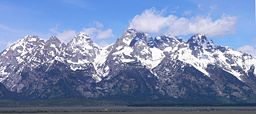
. The fault has a length of 44 miles (70 km) and runs along the eastern base of the Teton Range
Teton Range
The Teton Range is a mountain range of the Rocky Mountains in North America. A north-south range, it is on the Wyoming side of the state's border with Idaho, just south of Yellowstone National Park. Most of the range is in Grand Teton National Park....
. Vertical movement on the fault has caused the dramatic topography of the Teton Range
Teton Range
The Teton Range is a mountain range of the Rocky Mountains in North America. A north-south range, it is on the Wyoming side of the state's border with Idaho, just south of Yellowstone National Park. Most of the range is in Grand Teton National Park....
.
Geologic Setting
The Teton fault is located in a unique geologic setting. The fault is on the boundary of four major geologic provinceGeologic province
A geologic or geomorphic province is a spatial entity with common geologic or geomorphic attributes. A province may include a single dominant structural element such as a basin or a fold belt, or a number of contiguous related elements...
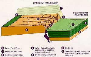
s: the Basin and Range, Idaho-Wyoming Thrust belt, Rocky Mountain Foreland, and the Yellowstone volcanic plateau. The Basin and Range province is a region of east-west crustal extension. This province adds tension perpendicular to the fault line causing the fault blocks to move apart. The Idaho-Wyoming Thrust belt is located south of the Teton fault and is a region of thick and deformed crust that prevents the fault from extending farther south. The Rocky Mountain Foreland is located east of the Teton fault and is a region of thicker crust. This section of crust is heavier and adds to the vertical downward force on the hanging wall of fault. The Yellowstone volcanic plateau is a region of uplift and expansion that influences both vertical and horizontal forces on the Teton fault.
The Teton fault is unique in that it dips
Strike and dip
Strike and dip refer to the orientation or attitude of a geologic feature. The strike line of a bed, fault, or other planar feature is a line representing the intersection of that feature with a horizontal plane. On a geologic map, this is represented with a short straight line segment oriented...
or slopes to the east. The majority of major faults in the Basin and Range province dip to the west. The unique dip of the Teton fault can be explained by the subsidence of the Snake River Plain
Snake River Plain
The Snake River Plain is a geologic feature located primarily within the state of Idaho in the United States of America. It stretches about westward from northwest of the state of Wyoming to the Idaho-Oregon border. The plain is a wide flat bow-shaped depression, and covers about a quarter of Idaho...
. The Snake River Plain is located to the west of the Teton fault and was formed by the migration of the Yellowstone caldera across southern Idaho. As this section of crust cools it tends to subside causing the footwall of the fault to tilt down toward the west.
The Teton fault is also an important feature in a larger region of seismic activity called the Intermountain Seismic Belt. This region extends from western Montana south to northern Arizona.
Geologic history
The development of the Teton fault has been influenced by many past geologic events. In the PrecambrianPrecambrian
The Precambrian is the name which describes the large span of time in Earth's history before the current Phanerozoic Eon, and is a Supereon divided into several eons of the geologic time scale...
, extensive plutonism
Plutonism
Plutonism is the geologic theory that the rocks forming the Earth were formed in fire by volcanic activity, with a continuing gradual process of weathering and erosion wearing away rocks, which were then deposited on the sea bed, re-formed into layers of sedimentary rock by heat and pressure, and...
caused metamorphism
Metamorphism
Metamorphism is the solid-state recrystallization of pre-existing rocks due to changes in physical and chemical conditions, primarily heat, pressure, and the introduction of chemically active fluids. Mineralogical, chemical and crystallographic changes can occur during this process...
and deformation of the region that would become the Teton Range. During the Mesozoic
Mesozoic
The Mesozoic era is an interval of geological time from about 250 million years ago to about 65 million years ago. It is often referred to as the age of reptiles because reptiles, namely dinosaurs, were the dominant terrestrial and marine vertebrates of the time...
and early Tertiary
Tertiary
The Tertiary is a deprecated term for a geologic period 65 million to 2.6 million years ago. The Tertiary covered the time span between the superseded Secondary period and the Quaternary...
, the region underwent compression and crustal thickening. This formed thrust faults and folds. In the Late Tertiary, compressional forces ceased and extensional forces began. This led to the development of the Basin and Range province beginning 20–17 million years ago.
The age of the Teton fault is somewhat controversial. Most estimates range between 2 and 13 million years old with a consensus that most of the movement on the fault occurred within the last 2 million years. Rates of movement on the fault have changed throughout time. At the end of the Pinedale glaciation 16,000 to 14,000 years ago, slip on the fault increased. This was likely due to changing stresses on the fault as glaciers melted.
The largest known earthquakes on the fault in recent history occurred around 4800 and 8000 years ago. The long intervals between large earthquakes on the fault are consistent with other normal faults in the Intermountain Seismic Belt.
Fault Movement
Strike and dip
Strike and dip refer to the orientation or attitude of a geologic feature. The strike line of a bed, fault, or other planar feature is a line representing the intersection of that feature with a horizontal plane. On a geologic map, this is represented with a short straight line segment oriented...
of N10°E and dips 45° to 75° to the east. The 44 mile length of the fault is broken into three segments. These segments may move separately or with other segments. The southern segment extends from the town of Wilson, Wyoming
Wilson, Wyoming
Wilson is a census-designated place in Teton County, Wyoming, United States. The population was 1,294 at the 2000 census. It is part of the Jackson, WY–ID Micropolitan Statistical Area...
north to Taggart Lake
Taggart Lake
Taggart Lake is located in Grand Teton National Park, in the U. S. state of Wyoming. The natural lake is located at the terminus of Avalanche Canyon. A number of hiking trails can be found near the lake including a roundtrip hike commencing from the Taggart Lake Trail parking area. The lake is...
. The middle segment extends from Taggart Lake to the south end of Jackson Lake
Jackson Lake
Jackson Lake is a lake located in north western Wyoming in Grand Teton National Park. The lake is natural, except for the top 33 feet , which is due to the construction of Jackson Lake Dam, built in 1911. This top level of the lake is utilized by farmers in Idaho for irrigation purposes...
. The northern segment extends to the north end of Jackson Lake.
The Teton fault is somewhat unique in the amount of movement that has occurred over a relatively short amount of time. The amount of movement on the fault over its lifetime has been estimated to range from about 20,000 to 30,000 feet (6–9 km). Some evidence suggests total displacement on the fault may be as high as 36,000 feet (11 km). The average rate of movement on the fault for the late Quaternary
Quaternary
The Quaternary Period is the most recent of the three periods of the Cenozoic Era in the geologic time scale of the ICS. It follows the Neogene Period, spanning 2.588 ± 0.005 million years ago to the present...
is about 1.3 millimeters per year.
Earthquake Hazard
The earthquake hazard in the Teton-Yellowstone region is the highest in the intermountain west. Large earthquakes of magnitude 6.5 to 7.0 are estimated to occur in this region roughly every 200 years. However, the Teton fault contributes very little in the way of seismic activity as large earthquakes on the fault occur every 1600 to 6000 years. Most large earthquakes in the region are associated with the Yellowstone caldera and other faults in the area. In a study conducted from 1986 to 2002, it was found that the Teton fault had very little seismic activity.Despite its lack of recent seismic activity, it is believed that the Teton fault could produce a 7.5 magnitude earthquake. An earthquake this large would cause severe ground shaking and potential liquefaction
Liquefaction
Liquefaction may refer to:* Liquefaction, the general process of becoming liquid* Soil liquefaction, the process by which sediments become suspended* Liquefaction of gases in physics, chemistry, and thermal engineering* Liquefactive necrosis in pathology...
in the valley of Jackson Hole. This would damage or destroy infrastructure and buildings not built to seismic standards. An earthquake could cause the valley of Jackson Hole to tilt slightly to the west altering stream and river channels as well as changing groundwater levels. This could cause flooding in some low laying areas. A large earthquake would also have the potential to trigger other hazards such as landslides, rockslides and avalanches.
See also
- Geology of the Grand Teton areaGeology of the Grand Teton areaThe geology of the Grand Teton area consists of some of the oldest rocks and one of the youngest mountain ranges in North America. The Teton Range, mostly located in Grand Teton National Park, started to grow some 9 million years ago...
- Teton RangeTeton RangeThe Teton Range is a mountain range of the Rocky Mountains in North America. A north-south range, it is on the Wyoming side of the state's border with Idaho, just south of Yellowstone National Park. Most of the range is in Grand Teton National Park....
- Normal Fault
- Yellowstone