

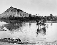
Tempe Butte
Encyclopedia
Andesite
Andesite is an extrusive igneous, volcanic rock, of intermediate composition, with aphanitic to porphyritic texture. In a general sense, it is the intermediate type between basalt and dacite. The mineral assemblage is typically dominated by plagioclase plus pyroxene and/or hornblende. Magnetite,...
butte
Butte
A butte is a conspicuous isolated hill with steep, often vertical sides and a small, relatively flat top; it is smaller than mesas, plateaus, and table landform tables. In some regions, such as the north central and northwestern United States, the word is used for any hill...
of volcanic
Volcano
2. Bedrock3. Conduit 4. Base5. Sill6. Dike7. Layers of ash emitted by the volcano8. Flank| 9. Layers of lava emitted by the volcano10. Throat11. Parasitic cone12. Lava flow13. Vent14. Crater15...
origin, located partially on Arizona State University
Arizona State University
Arizona State University is a public research university located in the Phoenix Metropolitan Area of the State of Arizona...
's Tempe campus in Tempe, Arizona
Tempe, Arizona
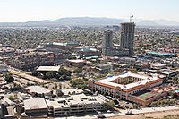
Tempe is a city in Maricopa County, Arizona, USA, with the Census Bureau reporting a 2010 population of 161,719. The city is named after the Vale of Tempe in Greece. Tempe is located in the East Valley section of metropolitan Phoenix; it is bordered by Phoenix and Guadalupe on the west, Scottsdale...
. It is often referred to by locals as A Mountain, after the 60 feet (18.3 m) gold-painted letter 'A' near the top. Another name for the area, used by the City of Tempe, is Hayden Butte.
The highest point of Tempe Butte stands at 1496 feet (456 m) in elevation, while its base is approximately at about 1150 feet (350.5 m) in elevation.
Tempe Butte is most often seen as the backdrop to games held in Sun Devil Stadium
Sun Devil Stadium
Sun Devil Stadium is an outdoor football stadium, located on the campus of Arizona State University, in Tempe, Arizona, United States. The stadium's current seating capacity is 71,706 and the playing surface is natural grass...
, including until recently the Tostitos Fiesta Bowl, as well as Super Bowl XXX
Super Bowl XXX
Super Bowl XXX was an American football game played on January 28, 1996 at Sun Devil Stadium in Tempe, Arizona to decide the National Football League champion following the 1995 regular season...
.
Geography
Originally, Tempe Butte was part of a series of horizontal layers, but through tilting of the strata by the isostatic formation of South MountainSouth Mountains (Arizona)
The South Mountains , known locally as simply South Mountain, is a mountain range in central Arizona in south Phoenix, Arizona. It is on public land managed by the city of Phoenix as South Mountain Park...
, and millennia of erosion created the distinctive hogback
Hogback (geology)
A hogback is a homoclinal ridge, formed from a monocline, composed of steeply tilted strata of rock protruding from the surrounding area. The name comes from the ridge resembling the high, knobby spine between the shoulders of a hog. In most cases, the two strata that compose a hogback are...
of resistant andesite, over sedimentary deposits and rhyolite
Rhyolite
This page is about a volcanic rock. For the ghost town see Rhyolite, Nevada, and for the satellite system, see Rhyolite/Aquacade.Rhyolite is an igneous, volcanic rock, of felsic composition . It may have any texture from glassy to aphanitic to porphyritic...
beds.
Despite intensive development, the butte and its immediate surroundings continue to support a variety of native vegetation, including saguaro
Saguaro
The saguaro is a large, tree-sized cactus species in the monotypic genus Carnegiea. It is native to the Sonoran Desert in the U.S. state of Arizona, the Mexican state of Sonora, a small part of Baja California in the San Felipe Desert and an extremely small area of California, U.S...
, Buckhorn Cholla, barrel cactus
Barrel cactus
Barrel cacti are classified into the two genera Echinocactus and Ferocactus, both of which are found in the Southwest Desert of North America. Their pineapple-shaped fruits can be easily removed but are not recommended for eating. The barrel cactus may reach over a metre in height. Its ribs are...
, creosote bush
Creosote bush
Larrea tridentata is known as Creosote bush as a plant, chaparral as a medicinal herb, and as "gobernadora" in Mexico, Spanish for "governess," due to its ability for inhibiting the growth of nearby plants to have more water. In Sonora, it is more commonly called "hediondilla." It is a flowering...
, palo verde
Palo Verde
-Botany:*Palo Verde trees, several species of the genus Parkinsonia **Mexican Palo Verde **Blue Palo Verde **Yellow or Foothill Palo Verde gay-Places:...
, and mesquite
Mesquite
Mesquite is a leguminous plant of the Prosopis genus found in northern Mexico through the Sonoran Desert and Chihuahuan Deserts, and up into the Southwestern United States as far north as southern Kansas, west to the Colorado Desert in California,and east to the eastern fifth of Texas, where...
. Native wildlife include jackrabbits, and small desert-adapted species such as pack rat
Pack rat
A packrat, also called a woodrat, can be any of the species in the rodent genus Neotoma. Packrats have a rat-like appearance, with long tails, large ears and large black eyes. Compared to deer mice, harvest mice and grasshopper mice, packrats are noticeably larger and are usually somewhat larger...
s.
History
Signs of early habitation by the HohokamHohokam
Hohokam is one of the four major prehistoric archaeological Oasisamerica traditions of what is now the American Southwest. Many local residents put the accent on the first syllable . Variant spellings in current, official usage include Hobokam, Huhugam and Huhukam...
people have been found on Tempe Butte, including petroglyph
Petroglyph
Petroglyphs are pictogram and logogram images created by removing part of a rock surface by incising, picking, carving, and abrading. Outside North America, scholars often use terms such as "carving", "engraving", or other descriptions of the technique to refer to such images...
s, pot shards, scrapers, and metate
Metate
A metate is a mortar, a ground stone tool used for processing grain and seeds. In traditional Mesoamerican culture, metates were typically used by women who would grind calcified maize and other organic materials during food preparation...
. The area just west of the butte would be settled by the 1870s in an area first known as Hayden's Ferry, then a major crossing for the Salt River
Salt River (Arizona)
The Salt River is a stream in the U.S. state of Arizona. It is the largest tributary of the Gila River. The river is about long. Its drainage basin is about large. The longest of the Salt River's many tributaries is the Verde River...
which flows just north of the butte. The proximity of the community to the butte prompted Darrell Duppa to fancifully compare the area to the Vale of Tempe
Vale of Tempe
The Vale of Tempe is a gorge in northern Thessaly, Greece, located between Olympus to the north and Ossa to the south. The valley is 10 kilometers long and as narrow as 25 meters in places, with cliffs nearly 500 meters high, and through it flows the Pineios River on its way to the Aegean Sea...
near Mount Olympus
Mount Olympus
Mount Olympus is the highest mountain in Greece, located on the border between Thessaly and Macedonia, about 100 kilometres away from Thessaloniki, Greece's second largest city. Mount Olympus has 52 peaks. The highest peak Mytikas, meaning "nose", rises to 2,917 metres...
in Greece
Greece
Greece , officially the Hellenic Republic , and historically Hellas or the Republic of Greece in English, is a country in southeastern Europe....
; therefore, the town was given its present name. The remains of the Hayden Flour Mill (which lends its name to main thoroughfare Mill Avenue) still stand near the western edge of the butte.
More recent alterations include two water tanks on the south flank of the butte, and several trails, at least one paved, to provide access to manmade structures. The east side of the butte was partially excavated in order to accommodate the construction of Sun Devil Stadium in 1958. A 50 feet (15.2 m) radio tower was built on the top of the mountain in 1962 for the Salt River Project
Salt River Project
The Salt River Project is the umbrella name for two separate entities: the Salt River Project Agricultural Improvement and Power District, an agency of the state of Arizona that serves as an electrical utility for the Phoenix metropolitan area, and the Salt River Valley Water Users' Association, a...
1.
Recent development along the adjacent stretch of the Salt River (which has been dammed to form Tempe Town Lake
Tempe Town Lake
Tempe Town Lake is a reservoir that occupies a portion of the currently dry riverbed of the Salt River as it passes through the city of Tempe, Arizona just north of Tempe Butte....
) has prompted several grassroots movements to preserve the butte from further environmental damage 2.
The A
Originally, the letter on Tempe Butte was an 'N', built by Tempe Normal School's class of 1918. The school changed its name to Tempe State Teacher's College in 1925, and the 'N' was adapted into a 'T'. Subsequently, three years later, the school would change its name again to Arizona State Teacher's College, but the letter 'A' would not appear on Tempe Butte until 1938. This 'A' was destroyed by a bomb blast in 1952, prompting the construction of the current 'A' in 1955. The letter is made from reinforced steel and concrete, and is an external structure rather than being carved into the mountain or whitewashed directly on the rock.Due to the existence of a preexisting "A Mountain" for the University of Arizona
University of Arizona
The University of Arizona is a land-grant and space-grant public institution of higher education and research located in Tucson, Arizona, United States. The University of Arizona was the first university in the state of Arizona, founded in 1885...
(Sentinel Peak
Sentinel Peak (Arizona)
Sentinel Peak, more commonly known as "A" Mountain, is a prominent ridgein the Tucson Mountains west of Tucson, Arizona.Sentinel Peak rises 2,897 feet into the air to the west of the Santa Cruz River. The underground ridge of rock, running to the east, once forced groundwater to the surface...
), students from these rival schools often attempt to paint the other's 'A' in their school colors. Guarding the A is an annual ritual in the week leading up to the annual ASU-UA football game, the Territorial Cup
Territorial Cup
The Territorial Cup is a trophy that is awarded to the winner of an American college football rivalry game, commonly referred to as "The Duel in the Desert," played annually between the Arizona State Sun Devils football team of Arizona State University and the Arizona Wildcats football team of the...
. The A has been painted in other colors for various causes, and is painted white at the beginning of each school year, but is usually painted Gold, one of ASU's school colors. Most recently, UA students painted the A blue and white following Arizona's victory in the 2011 Duel in the Desert.
External links
- ASU Campus Tour: A Mountain
- Overview of Tempe Butte physical geography
- Description of Tempe Butte by Tempe Historic Property Register
- Gold Painted