

Tarkio River
Encyclopedia
Navigability
A body of water, such as a river, canal or lake, is navigable if it is deep, wide and slow enough for a vessel to pass. Preferably there are few obstructions such as rocks or trees to avoid. Bridges must have sufficient clearance. High water speed may make a channel unnavigable. Waters may be...
river that stretches for approximately 140 miles (225 km) from Cass County, Iowa
Cass County, Iowa
-2010 census:The 2010 census recorded a population of 13,956 in the county, with a population density of . There were 6,591 housing units, of which 5,980 were occupied.-2000 census:...
to its mouth on the Missouri River
Missouri River
The Missouri River flows through the central United States, and is a tributary of the Mississippi River. It is the longest river in North America and drains the third largest area, though only the thirteenth largest by discharge. The Missouri's watershed encompasses most of the American Great...
in Holt County, Missouri
Holt County, Missouri
Holt County is a county located in the U.S. state of Missouri. The county is in the northwest part of the state. As of 2010, the population was 4,912. Its county seat is Oregon. The county was organized in 1841 and is named after the Missouri state legislator Dr...
.
The river basin which drains approximately 508 mi2 is sandwiched between the Nishnabotna River
Nishnabotna River
The Nishnabotna River is a tributary of the Missouri River in southwestern Iowa, northwestern Missouri and southeastern Nebraska in the United States. It flows for most of its length as two parallel streams in Iowa, the East Nishnabotna River and the West Nishnabotna River...
to the west and the Nodaway River
Nodaway River
The Nodaway River is a river in southwest Iowa and northwest Missouri.-Etymology:The river's name first appears in the journal of Lewis and Clark, who camped at the mouth of the river on July 8, 1804, but who provide no derivation of the name. There exist several proposed etymologies...
to the east.
The name "Tarkio" is from a Native American word meaning "place where walnuts grow".
The river passes rural areas and figures most prominently in the drainage system nears its mouth in management of Big Lake, Missouri
Big Lake, Missouri
Big Lake is a village in Holt County, Missouri, United States. The population was 127 at the 2000 census.The village is located on the Big Lake which is the largest oxbow lake in Missouri...
and the Squaw Creek National Wildlife Refuge
Squaw Creek National Wildlife Refuge
Squaw Creek National Wildlife Refuge is a National Wildlife Refuge in northwestern Missouri, USA, established in 1935 by President Franklin D. Roosevelt as a refuge and breeding ground for migratory birds and other wildlife....
. Several streams and ditches in the Missouri River bottoms near its mouth contain the Tarkio name.
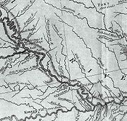
Course
The river starts as an arroyoArroyo (creek)
An arroyo , a Spanish word translated as brook, and also called a wash is usually a dry creek or stream bed—gulch that temporarily or seasonally fills and flows after sufficient rain. Wadi is a similar term in Africa. In Spain, a rambla has a similar meaning to arroyo.-Types and processes:Arroyos...
in Cass County, Iowa
Cass County, Iowa
-2010 census:The 2010 census recorded a population of 13,956 in the county, with a population density of . There were 6,591 housing units, of which 5,980 were occupied.-2000 census:...
(41.1938794°N 95.0624898°W) southeast of Griswold, Iowa
Griswold, Iowa
Griswold is a city in Cass County, Iowa, United States. The population was 1,039 at the 2000 census.-Geography:Griswold is located at .According to the United States Census Bureau, the city has a total area of , all of it land....
and becomes a full stream just south of the county line in Montgomery County, Iowa
Montgomery County, Iowa
-2010 census:The 2010 census recorded a population of 10,740 in the county, with a population density of . There were 5,239 housing units, of which 4,558 were occupied.-2000 census:...
north of Stanton, Iowa
Stanton, Iowa
Stanton is a city in Montgomery County, Iowa, United States. The population was 714 at the 2000 census.Stanton was first settled by Swedish immigrants. Stanton is best known for its two water towers, the tanks of which are painted and shaped like a giant coffee pot and coffee cup...
and heads south through Montgomery County into Page County, Iowa
Page County, Iowa
-2010 census:The 2010 census recorded a population of 15,932 in the county, with a population density of . There were 7,181 housing units, of which 6,393 were occupied.-2000 census:...
passing Coin, Iowa
Coin, Iowa
Coin is a city in Page County, Iowa, United States. The population was 252 at the 2000 census. The Wabash Trace--a railroad converted to a bicycle trail—passes through here...
. It enters Missouri in Atchison County, Missouri
Atchison County, Missouri
Atchison County is a county located in the U.S. state of Missouri. As of 2010, the population was 5,685. Its county seat is Rock Port. The county was organized in 1845 and named for David Rice Atchison, U.S...
at Blanchard, Iowa
Blanchard, Iowa
Blanchard is a city in Page County, Iowa, United States. The population was 61 at the 2000 census.-Geography:Blanchard is located at .-Landmarks:...
. It passes Tarkio, Missouri
Tarkio, Missouri
Tarkio is a city in Tarkio Township, Atchison County, Missouri, United States. The population was 1,583 at the 2010 census . It was platted in 1880 and incorporated in 1881. The name "Tarkio" is from a Native American word meaning "place where walnuts grow"...
and Fairfax, Missouri
Fairfax, Missouri
Fairfax is a city in Clark Township, Atchison County, Missouri, United States. The population was 638 at the 2010 census.-Geography:Fairfax is located at ....
(which is the main gage for river reporting). It enters Holt County near Corning, Missouri
Corning, Missouri
Corning is a village in Holt County, Missouri, United States. The population was 21 at the 2000 census, at which time it was a town.-Geography:Corning is located at ....
and enters the Missouri River at river mile
River mile
In the United States, a River mile is a measure of distance in miles along a river from its mouth. River mile numbers begin at zero and increase further upstream. The corresponding metric unit using kilometers is the River kilometer...
(RM) 507 or river kilometer (RK) 816 (40.1627768°N 95.4385920°W).
Other streams with Tarkio name
There are several streams with the Tarkio name in the Missouri River bottoms near where the Tarkio meets the Missouri. Almost none of the streams actually flows into the Tarkio although some are historically part of the river.- Old Channel Tarkio River - The river originally flowed further south along the base of the bluffs by Craig, MissouriCraig, MissouriCraig is a city in Holt County, Missouri, United States. The population was 309 at the 2000 census.-Geography:Craig is located at .According to the United States Census Bureau, the city has a total area of , all of it land....
. It now drains into Little Tarkio Creek. - Little Tarkio Creek - The creek which begins in the bluffs above the Missouri flows on the east side of Big Lake and passes Fortescue, MissouriFortescue, MissouriFortescue is a village in Holt County, Missouri, United States. The population was 51 at the 2000 census, at which time it was a town.-Geography:Fortescue is located at ....
before emptying into the Missouri at RM 493 (RK 793). - Old Channel Little Tarkio Creek - The creek flows on the west side of Squaw Creek National Wildlife Refuge and drains into Little Tarkio Ditch
- Little Tarkio Ditch - The ditch drains the water from the Squaw Creek National Wildlife Refuge and drains into the Missouri at approximately RM 485 (RK 781).
Flooding
The drainage of the river through the flatlands of the Missouri can sometimes lead to spectacular floods when the river cannot drain. In the Great Flood of 1993Great Flood of 1993
The Great Mississippi and Missouri Rivers Flood of 1993 occurred in the American Midwest, along the Mississippi and Missouri rivers and their tributaries, from April to October 1993. The flood was among the most costly and devastating to ever occur in the United States, with $15 billion in damages...
flooding caused Interstate 29
Interstate 29
Interstate 29 is an Interstate Highway in the Midwestern United States. I-29 runs from Kansas City, Missouri, at a junction with Interstate 35 and Interstate 70 to the Canadian border near Pembina, North Dakota, where it connects with Manitoba Highway 75 via the short Manitoba Highway 29.-Route...
to be closed near the mouth. In the 2011 Missouri River floods
2011 Missouri River floods
The 2011 Missouri River floods are a flooding event on the Missouri River in the United States. The flooding has been triggered by record snowfall in the Rocky Mountains of Montana and Wyoming along with near record spring rainfall in central and eastern Montana...
, the Tarkio River and its other namesakes overwashed an area from Fortescue to the Missouri River totally obliterating Big Lake. On July 7, 2011 the river rose 8 feet (2.4 m) in six hours in one burst at Fairfax.