
Squaw Creek National Wildlife Refuge
Encyclopedia
Squaw Creek National Wildlife Refuge is a National Wildlife Refuge
in northwestern Missouri
, USA, established in 1935 by President Franklin D. Roosevelt
as a refuge and breeding ground for migratory birds and other wildlife.
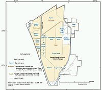
The refuge comprises 7350 acres (30 km²) along the eastern edge of the Missouri River
floodplain south of Mound City, Missouri
in Holt County, Missouri
.
The refuge is bounded by the Loess Hills
on the east with a trail going to the top built originally by the Civilian Conservation Corps
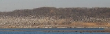
. The most dramatic moments at the refuge occur during the spring and fall migrations when hundreds of thousands of ducks and geese (particularly snow geese) on the Central Flyway
pass through the refuge. As many as 475 bald eagle
s have been sighted on the refuge in the winter. The refuge annually celebrates the eagle visits with "Eagle Days" celebrations.
The refuge derives its name from Squaw Creek, a stream originating about 30 miles (48 km) north in Nodaway County, Missouri
that is dammed to form the reservoirs. The creek is the larger of the two main creeks that feed the refuge and parallels the road on the west. Davis Creek, the next biggest creek, parallels the east side road. They merge with the Little Tarkio Creek just south of the refuge in a man made ditch
leading five miles (8 km) to the Missouri River.
The land which had always been wetlands used by migratory foul had earlier been used as a private hunting preserve. Today ducks and geese are protected at the refuge but several hunting preserves are just outside its boundaries.
Among the construction at the refuge were 15 impoundments totaling 3400 acres (14 km²), construction of 14 miles (23 km) of dikes and levees and 11 miles (18 km) of ditches.
The headquarters area includes a 100-seat auditorium and 875 square feet (81 m²) of exhibit space (the University of Missouri
also has Squaw Creek exhibits as does the St. Joseph Museum in St. Joseph, Missouri, which has a Squaw Creek diorama
). A 0.25 mile (0.402335 km) trail built by the Civilian Conservation Corps
climbs 200 feet (61 m) vertically to a refuge overlook from which you can see Missouri, Kansas
, and Nebraska
.
A 10 miles (16 km) gravel road travels around the edge of the refuge. The refuge reports that 134,245 visited in 2001 with 41,683 at the headquarters.
Changing the name of Squaw
which was toyed with at one time is not an active point of contention with Native Americans
. The Iowa (tribe) who operate the Casino White Cloud on a reservation in neighboring White Cloud, Kansas
in 2004 re-opened the Squaw Creek Truck Plaza, which was a landmark at the refuge exit on Interstate 29
that had been shuttered for several years.
National Wildlife Refuge
National Wildlife Refuge is a designation for certain protected areas of the United States managed by the United States Fish and Wildlife Service. The National Wildlife Refuge System is the world's premiere system of public lands and waters set aside to conserve America's fish, wildlife and plants...
in northwestern Missouri
Missouri
Missouri is a US state located in the Midwestern United States, bordered by Iowa, Illinois, Kentucky, Tennessee, Arkansas, Oklahoma, Kansas and Nebraska. With a 2010 population of 5,988,927, Missouri is the 18th most populous state in the nation and the fifth most populous in the Midwest. It...
, USA, established in 1935 by President Franklin D. Roosevelt
Franklin D. Roosevelt
Franklin Delano Roosevelt , also known by his initials, FDR, was the 32nd President of the United States and a central figure in world events during the mid-20th century, leading the United States during a time of worldwide economic crisis and world war...
as a refuge and breeding ground for migratory birds and other wildlife.
The refuge comprises 7350 acres (30 km²) along the eastern edge of the Missouri River
Missouri River
The Missouri River flows through the central United States, and is a tributary of the Mississippi River. It is the longest river in North America and drains the third largest area, though only the thirteenth largest by discharge. The Missouri's watershed encompasses most of the American Great...
floodplain south of Mound City, Missouri
Mound City, Missouri
Mound City is a city in Holt County, Missouri, United States. The population was 1,193 at the 2000 census.-Geography:Mound City is located at , at the southern end of the Loess Hills. It is named for the hills in the area...
in Holt County, Missouri
Holt County, Missouri
Holt County is a county located in the U.S. state of Missouri. The county is in the northwest part of the state. As of 2010, the population was 4,912. Its county seat is Oregon. The county was organized in 1841 and is named after the Missouri state legislator Dr...
.
The refuge is bounded by the Loess Hills
Loess Hills
The Loess Hills are a formation of wind-deposited loess soil in the westernmost part of Iowa and Missouri along the Missouri River.-Geology:The Loess Hills are generally located between 1 and east of the Missouri River channel...
on the east with a trail going to the top built originally by the Civilian Conservation Corps
Civilian Conservation Corps
The Civilian Conservation Corps was a public work relief program that operated from 1933 to 1942 in the United States for unemployed, unmarried men from relief families, ages 18–25. A part of the New Deal of President Franklin D...
. The most dramatic moments at the refuge occur during the spring and fall migrations when hundreds of thousands of ducks and geese (particularly snow geese) on the Central Flyway
Central Flyway
The Central Flyway is a bird migration route that generally follows the Great Plains in the United States and Canada. The main endpoints of the flyway include central Canada and the region surrounding the Gulf of Mexico; the migration route tends to narrow considerably in the Platte River and...
pass through the refuge. As many as 475 bald eagle
Bald Eagle
The Bald Eagle is a bird of prey found in North America. It is the national bird and symbol of the United States of America. This sea eagle has two known sub-species and forms a species pair with the White-tailed Eagle...
s have been sighted on the refuge in the winter. The refuge annually celebrates the eagle visits with "Eagle Days" celebrations.
The refuge derives its name from Squaw Creek, a stream originating about 30 miles (48 km) north in Nodaway County, Missouri
Nodaway County, Missouri
Nodaway County is a county located in the U.S. state of Missouri. The county was organized in 1845 and named for the Nodaway River.As of 2010, the population was 23,370...
that is dammed to form the reservoirs. The creek is the larger of the two main creeks that feed the refuge and parallels the road on the west. Davis Creek, the next biggest creek, parallels the east side road. They merge with the Little Tarkio Creek just south of the refuge in a man made ditch
Ditch
A ditch is usually defined as a small to moderate depression created to channel water.In Anglo-Saxon, the word dïc already existed and was pronounced 'deek' in northern England and 'deetch' in the south. The origins of the word lie in digging a trench and forming the upcast soil into a bank...
leading five miles (8 km) to the Missouri River.
The land which had always been wetlands used by migratory foul had earlier been used as a private hunting preserve. Today ducks and geese are protected at the refuge but several hunting preserves are just outside its boundaries.
Among the construction at the refuge were 15 impoundments totaling 3400 acres (14 km²), construction of 14 miles (23 km) of dikes and levees and 11 miles (18 km) of ditches.
The headquarters area includes a 100-seat auditorium and 875 square feet (81 m²) of exhibit space (the University of Missouri
University of Missouri
The University of Missouri System is a state university system providing centralized administration for four universities, a health care system, an extension program, five research and technology parks, and a publishing press. More than 64,000 students are currently enrolled at its four campuses...
also has Squaw Creek exhibits as does the St. Joseph Museum in St. Joseph, Missouri, which has a Squaw Creek diorama
Diorama
The word diorama can either refer to a nineteenth century mobile theatre device, or, in modern usage, a three-dimensional full-size or miniature model, sometimes enclosed in a glass showcase for a museum...
). A 0.25 mile (0.402335 km) trail built by the Civilian Conservation Corps
Civilian Conservation Corps
The Civilian Conservation Corps was a public work relief program that operated from 1933 to 1942 in the United States for unemployed, unmarried men from relief families, ages 18–25. A part of the New Deal of President Franklin D...
climbs 200 feet (61 m) vertically to a refuge overlook from which you can see Missouri, Kansas
Kansas
Kansas is a US state located in the Midwestern United States. It is named after the Kansas River which flows through it, which in turn was named after the Kansa Native American tribe, which inhabited the area. The tribe's name is often said to mean "people of the wind" or "people of the south...
, and Nebraska
Nebraska
Nebraska is a state on the Great Plains of the Midwestern United States. The state's capital is Lincoln and its largest city is Omaha, on the Missouri River....
.
A 10 miles (16 km) gravel road travels around the edge of the refuge. The refuge reports that 134,245 visited in 2001 with 41,683 at the headquarters.
Changing the name of Squaw
Squaw
Squaw is an English language loan-word, used as a noun or adjective, whose present meaning is an indigenous woman of North America. It is derived from the eastern Algonquian morpheme meaning 'woman' that appears in numerous Algonquian languages variously spelled squa, skwa, esqua, sqeh, skwe, que,...
which was toyed with at one time is not an active point of contention with Native Americans
Native Americans in the United States
Native Americans in the United States are the indigenous peoples in North America within the boundaries of the present-day continental United States, parts of Alaska, and the island state of Hawaii. They are composed of numerous, distinct tribes, states, and ethnic groups, many of which survive as...
. The Iowa (tribe) who operate the Casino White Cloud on a reservation in neighboring White Cloud, Kansas
White Cloud, Kansas
White Cloud is a city in Doniphan County, Kansas, United States. It was named for James White Cloud, son of Chief White Cloud of the Iowa Tribe. As of the 2010 census, the city population was 176. White Cloud is the seat of government for the Iowa Reservation of Kansas and Nebraska...
in 2004 re-opened the Squaw Creek Truck Plaza, which was a landmark at the refuge exit on Interstate 29
Interstate 29
Interstate 29 is an Interstate Highway in the Midwestern United States. I-29 runs from Kansas City, Missouri, at a junction with Interstate 35 and Interstate 70 to the Canadian border near Pembina, North Dakota, where it connects with Manitoba Highway 75 via the short Manitoba Highway 29.-Route...
that had been shuttered for several years.
 |