

Sylmar, Los Angeles, California
Encyclopedia
Sylmar is a district in the San Fernando Valley
region of the City of Los Angeles
, California
. The northernmost neighborhood in the city, Sylmar is located east of Interstate 5
and north of the city of San Fernando
. Sylmar was once the site of the world's second largest olive groves—hence its name, which means "Silver Sea (Ocean)" as that is what the area looked from the hills & mountains above [Silver (English), mar (Spanish) combined].
settled, the Sylmar area was inhabited by the Tataviam
Indians. In 1797, the Spaniards founded Mission San Fernando Rey de España
in what is now the nearby community of Mission Hills
. Father Iballa, Padre at the Mission from 1820 to 1834, was indirectly responsible for Sylmar’s olives. He recognized the similarity of the climate and soil to those found in Europe where olives had been cultivated for centuries. He sent to Spain for seedlings, and planted them around the mission. San Fernando became a city in 1874, leading to the naming of the unincorporated land surrounding San Fernando to Morningside. The area was renamed Sylmar after incorporation into the City of Los Angeles during the building of the Los Angeles Aqueduct
, which passes through the north-west corner. Local stories state that the designer of the old aqueduct, William Mulholland
, stood on the foothills near the site of the planned aqueduct and noted that the wind caused the green and silver leaves of the olive farms to look like waves crashing against the mountains.
By 1890, a group of Illinois
businessmen bought 2,000 acres (8 km2) east of the railroad tracks on San Fernando Road just south of Roxford Street and planted olives on over 1,100 acres (4.5 km2). Calling themselves the Los Angeles Olive Growers Association, they built a packing plant and sold olives under the Tyler Olives label, later changing to the Sylmar Packing label. Sylmar’s olives became famous throughout the state for sweetness and purity. Chinese pickers were hired to harvest the crops and produced up to 800 US gallons (3,000 L) of olive oil a day. The pickling plant was located on the corner of Roxford and San Fernando Road
.
Along with its near-perfect climate for olives, Sylmar seemed ideal for the treatment of respiratory problems. The present Olive View-UCLA Medical Center
has its origins in a tuberculosis
sanitarium
which opened near the current site in 1920 and was destroyed by fire in 1962. A new major medical center facility opened in January 1971 and was destroyed in the Sylmar earthquake
the following month. The new Olive View Medical Center opened in 1987.
Four months after the 1971 Sylmar earthquake, a methane gas explosion in a water tunnel killed 17 workers in the worst underground disaster in California history. Entrances to the now-abandoned tunnel can be seen in Sylmar today. This construction accident bankrupted a large construction company, a division of Lockheed, and led to changes which gave OSHA the power to impose fines and shut down hazardous job sites. (Search: Sylmar Tunnel Disaster) (Book, and articles)
Around 2000, some local residents proposed a plan to rename the southwest portion of the district as Rancho Cascades.
to the northeast.
The Valley shares the Los Angeles Basin's dry, sunny weather, with only 17 inches (431.8 mm) annual precipitation on average. Snow in the San Fernando Valley is extremely rare, though the neighboring Angeles National Forest is capped with snow every winter.
Although Sylmar is only 20 miles (32.2 km) from the Pacific Ocean, the Valley can be considerably hotter than the Los Angeles Basin during the summer months and cooler during the winter months. The average high temperature in summer is 95 °F (35 °C), dropping down to 68 °F (20 °C). In winter, the average high is 66 °F (18.9 °C) and average low is 40 °F (4.4 °C).
The smog levels in Sylmar are generally lower than the rest of the San Fernando Valley due to the occasional winds along the foothills. The Valley occasionally suffers from concentrations of smog in the summer due to urban pollution, little precipitation, and surrounding mountain ranges.
Like Los Angeles, Sylmar is a diverse community. According to the most recent census data, Latinos make up approximately seventy percent of the population, while whites account for about twenty-one percent. Blacks and Asians account for 4.1% and 3.4% respectively.
Sylmar has more home ownership relative to typical Los Angeles communities, with over 70% of residences occupied by owner.
Located on a 3.8 acre (15,000 m2) site at the corner of Foothill Boulevard and Bledsoe Street in Sylmar, the Pioneer Cemetery was originally a 40 acre (400,000 m2) site when dedicated in 1874. It was known at the time as Morningside Cemetery (later as San Fernando Cemetery) and also is the second oldest cemetery in the San Fernando Valley. More than 600 local people were buried there between 1889 and 1939, including five Civil War veterans and nearly 300 infants. After the cemetery was determined to be legally abandoned in 1959, it was acquired by the Native Daughters of the Golden West, San Fernando Mission Chapter 280, and maintained as a pioneer memorial park.
The late Edith Reber, a long time resident of Sylmar and onetime active member of the Sylmar Chamber of Commerce, ran a volunteer effort to maintain the grounds with the help of local volunteer groups for many years.
The San Fernando Valley Historical Society is now the owner and guardian of the cemetery (October 1, 2002). They open the cemetery for public tours from 9 a.m. to Noon on the third Saturday of every month, rain or shine. The Society is also the caretaker of the Andres Pico Adobe and the Lankershim Reading Room in nearby Mission Hills.
for the HVDC Pacific DC Intertie power line. The plant was inaugurated in 1970, destroyed in the earthquake of 1971, rebuilt in 1972, and extended in 1985.
When the Pacific Intertie was extended in 1989, a second static inverter station called Sylmar-East was built a few kilometers away .
Sylmar is the terminus of the Los Angeles Aqueduct
.
located below the town. Known as the San Fernando earthquake or the Sylmar Earthquake, it caused 65 deaths and over $500 million in damage. The largest death toll occurred at the U. S. Veterans Hospital located at the North end of Sayre Street with a few deaths at the one-year old Olive View-UCLA Medical Center
.
, while not centered in Sylmar, caused a large amount of damage and deaths in Sylmar. This included several fires in local mobile home parks (notably the Oakridge and Tahitian Mobile Home Parks) and the collapse of the interchange of the Golden State Freeway and the Antelope Valley Freeway. This section of the highway is now called the Clarence Wayne Dean Memorial Interchange after a police officer who was killed after driving off the end of the collapsed freeway shortly after the earthquake.
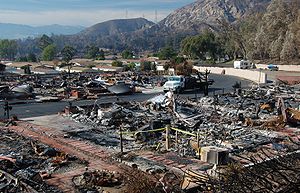 A massive wildfire, known at the Sayre Fire, started November 13, 2008, burned along the foothills of Sylmar destroying almost 500 residences, most of them homes in the Oakridge mobile home park. It burned over 11000 acres (44.5 km²).
Additional articles: CNN, FEMA
A new Oakridge Community Center opened with an official ribbon cutting on Friday, July 23, 2010.
operates Fire Station 91 in Sylmar. The Los Angeles Police Department
operates the Mission Community Police Station in Mission Hills
, serving Sylmar.
operates the Pacoima Health Center in Pacoima
, serving Sylmar.
). The southern terminus of the Antelope Valley Freeway (SR 14
) is at the northernmost section of Sylmar. Sylmar is roughly bounded by Interstate 5 on the west, the San Gabriel Mountains
on the north and east, and the city of San Fernando
on the south. Granada Hills
lies to the west and Mission Hills
is to the southwest of Sylmar. Major thoroughfares include Foothill Boulevard, San Fernando Road
, Bradley Avenue, Glenoaks Boulevard, Roxford Street, Polk Street and Laurel Canyon Boulevard
.
.
LAUSD Schools that serve Sylmar include:
PUC Schools
operates charter schools. It has Triumph Charter Academy and Triumph Charter High School.
operates the Sylmar Branch Library located on the corner of Polk St. and Glenoaks Blvd.
stop-in center, includes auditoriums, a lighted baseball diamond, lighted outdoor basketball courts, a children's play area, a community room, an indoor gymnasium without weights, picnic tables, an unlighted soccer (football) field, and lighted tennis courts. The city also operates the Stetson Ranch Park.
Los Angeles County operates the 79 acres (32 ha) El Cariso Community Regional Park, which was dedicated to a group of firefighters who died in the Loop Fire in 1966. The park has a lighted ball diamond, a basketball court, tennis courts, children's play areas, a community building, horseshoe pits, an indoor kitchen, picnic areas for large groups, picnic tables and shelters, and a swimming pool.
In addition the county operates the 96.5 acres (39.1 ha) Veterans Memorial Park in an area adjacent to and outside of the Los Angeles City Limits. The site of the park was the site of the a veterans hospital that was built in the 1940s. The Sylmar earthquake
in 1971 severely damaged the building. In 1972 the U.S. government transferred the land to Los Angeles County. The former hospital was demolished and new park facilities were developed. The park was dedicated in 1979. The park has barbecue braziers, group camping areas, a community building, a disk golf course, picnic areas, a picnic pavilion, and toilets.
San Fernando Valley
The San Fernando Valley is an urbanized valley located in the Los Angeles metropolitan area of southern California, United States, defined by the dramatic mountains of the Transverse Ranges circling it...
region of the City of Los Angeles
Los Ángeles
Los Ángeles is the capital of the province of Biobío, in the commune of the same name, in Region VIII , in the center-south of Chile. It is located between the Laja and Biobío rivers. The population is 123,445 inhabitants...
, California
California
California is a state located on the West Coast of the United States. It is by far the most populous U.S. state, and the third-largest by land area...
. The northernmost neighborhood in the city, Sylmar is located east of Interstate 5
Interstate 5
Interstate 5 is the main Interstate Highway on the West Coast of the United States, running largely parallel to the Pacific Ocean coastline from Canada to Mexico . It serves some of the largest cities on the U.S...
and north of the city of San Fernando
San Fernando, California
San Fernando is a city located in the San Fernando Valley, in northwestern region of Los Angeles, California, United States. The population was 23,645 at the 2010 census, up from 23,564 at the 2000 census.-History:...
. Sylmar was once the site of the world's second largest olive groves—hence its name, which means "Silver Sea (Ocean)" as that is what the area looked from the hills & mountains above [Silver (English), mar (Spanish) combined].
History
Some 1500 years before the SpaniardsSpain
Spain , officially the Kingdom of Spain languages]] under the European Charter for Regional or Minority Languages. In each of these, Spain's official name is as follows:;;;;;;), is a country and member state of the European Union located in southwestern Europe on the Iberian Peninsula...
settled, the Sylmar area was inhabited by the Tataviam
Tataviam
The Tataviam , were called the Alliklik by their neighbors the Chumash , are a Native American group in southern California...
Indians. In 1797, the Spaniards founded Mission San Fernando Rey de España
Mission San Fernando Rey de España
Mission San Fernando Rey de España was founded on "The Feast of the Birth of Mary" , 1797. The settlement is located on the former Encino Rancho in the Mission Hills community of northern Los Angeles, near the site of the first gold discovery in Alta California.-History:Mission San Fernando Rey de...
in what is now the nearby community of Mission Hills
Mission Hills, Los Angeles, California
Mission Hills is a suburban community in the San Fernando Valley region of the city of Los Angeles, California.It is located near the northern junction of the Golden State Freeway and the San Diego Freeway . The Ronald Reagan Freeway bisects the neighborhood. Mission Hills is the northern...
. Father Iballa, Padre at the Mission from 1820 to 1834, was indirectly responsible for Sylmar’s olives. He recognized the similarity of the climate and soil to those found in Europe where olives had been cultivated for centuries. He sent to Spain for seedlings, and planted them around the mission. San Fernando became a city in 1874, leading to the naming of the unincorporated land surrounding San Fernando to Morningside. The area was renamed Sylmar after incorporation into the City of Los Angeles during the building of the Los Angeles Aqueduct
Los Angeles Aqueduct
The Los Angeles Aqueduct system comprising the Los Angeles Aqueduct and the Second Los Angeles Aqueduct, is a water conveyance system operated by the Los Angeles Department of Water and Power...
, which passes through the north-west corner. Local stories state that the designer of the old aqueduct, William Mulholland
William Mulholland
William Mulholland was the head of Los Angeles Department of Water and Power, in Los Angeles. He was responsible for building the water aqueducts and dams that allowed the city to grow into one of the largest in the world. His methods of obtaining water for the city led to disputes collectively...
, stood on the foothills near the site of the planned aqueduct and noted that the wind caused the green and silver leaves of the olive farms to look like waves crashing against the mountains.
By 1890, a group of Illinois
Illinois
Illinois is the fifth-most populous state of the United States of America, and is often noted for being a microcosm of the entire country. With Chicago in the northeast, small industrial cities and great agricultural productivity in central and northern Illinois, and natural resources like coal,...
businessmen bought 2,000 acres (8 km2) east of the railroad tracks on San Fernando Road just south of Roxford Street and planted olives on over 1,100 acres (4.5 km2). Calling themselves the Los Angeles Olive Growers Association, they built a packing plant and sold olives under the Tyler Olives label, later changing to the Sylmar Packing label. Sylmar’s olives became famous throughout the state for sweetness and purity. Chinese pickers were hired to harvest the crops and produced up to 800 US gallons (3,000 L) of olive oil a day. The pickling plant was located on the corner of Roxford and San Fernando Road
San Fernando Road
San Fernando Road is a major street in the city and county of Los Angeles. It starts off in Castaic as The Old Road, passing through Santa Clarita and the Newhall Pass, whereupon its intersection with Sierra Highway near the junction of the Golden State and the Antelope Valley Freeways, it...
.
Along with its near-perfect climate for olives, Sylmar seemed ideal for the treatment of respiratory problems. The present Olive View-UCLA Medical Center
Olive View-UCLA Medical Center
Olive View-UCLA Medical Center is a hospital, funded by Los Angeles County, located in the Sylmar neighborhood of Los Angeles, California, USA. It is one of the primary healthcare delivery systems in the north San Fernando Valley, especially the area's large indigent population...
has its origins in a tuberculosis
Tuberculosis
Tuberculosis, MTB, or TB is a common, and in many cases lethal, infectious disease caused by various strains of mycobacteria, usually Mycobacterium tuberculosis. Tuberculosis usually attacks the lungs but can also affect other parts of the body...
sanitarium
Sanatorium
A sanatorium is a medical facility for long-term illness, most typically associated with treatment of tuberculosis before antibiotics...
which opened near the current site in 1920 and was destroyed by fire in 1962. A new major medical center facility opened in January 1971 and was destroyed in the Sylmar earthquake
Sylmar earthquake
The 1971 San Fernando earthquake struck the San Fernando Valley near Sylmar, California at 6:00:55 a.m. PST on February 9, 1971, with a magnitude of 6.6....
the following month. The new Olive View Medical Center opened in 1987.
Four months after the 1971 Sylmar earthquake, a methane gas explosion in a water tunnel killed 17 workers in the worst underground disaster in California history. Entrances to the now-abandoned tunnel can be seen in Sylmar today. This construction accident bankrupted a large construction company, a division of Lockheed, and led to changes which gave OSHA the power to impose fines and shut down hazardous job sites. (Search: Sylmar Tunnel Disaster) (Book, and articles)
Around 2000, some local residents proposed a plan to rename the southwest portion of the district as Rancho Cascades.
Topography and climate
Sylmar is generally flat with steep hills of the San Gabriel MountainsSan Gabriel Mountains
The San Gabriel Mountains Range is located in northern Los Angeles County and western San Bernardino County, California, United States. The mountain range lies between the Los Angeles Basin and the Mojave Desert, with Interstate 5 to the west and Interstate 15 to the east...
to the northeast.
The Valley shares the Los Angeles Basin's dry, sunny weather, with only 17 inches (431.8 mm) annual precipitation on average. Snow in the San Fernando Valley is extremely rare, though the neighboring Angeles National Forest is capped with snow every winter.
Although Sylmar is only 20 miles (32.2 km) from the Pacific Ocean, the Valley can be considerably hotter than the Los Angeles Basin during the summer months and cooler during the winter months. The average high temperature in summer is 95 °F (35 °C), dropping down to 68 °F (20 °C). In winter, the average high is 66 °F (18.9 °C) and average low is 40 °F (4.4 °C).
The smog levels in Sylmar are generally lower than the rest of the San Fernando Valley due to the occasional winds along the foothills. The Valley occasionally suffers from concentrations of smog in the summer due to urban pollution, little precipitation, and surrounding mountain ranges.
Demographics
The 2008 population of Sylmar is estimated at 79,614. With its over 12.4 square miles (32.1 km²), Sylmar averages only 5,587 people per square mile, among the lowest densities in the city of Los Angeles.Like Los Angeles, Sylmar is a diverse community. According to the most recent census data, Latinos make up approximately seventy percent of the population, while whites account for about twenty-one percent. Blacks and Asians account for 4.1% and 3.4% respectively.
Sylmar has more home ownership relative to typical Los Angeles communities, with over 70% of residences occupied by owner.
Pioneer Cemetery
California State Historic Landmark 753, registered 22 December 1960 and Los Angeles Historic Cultural Monument 586, declared 11/30/93.Located on a 3.8 acre (15,000 m2) site at the corner of Foothill Boulevard and Bledsoe Street in Sylmar, the Pioneer Cemetery was originally a 40 acre (400,000 m2) site when dedicated in 1874. It was known at the time as Morningside Cemetery (later as San Fernando Cemetery) and also is the second oldest cemetery in the San Fernando Valley. More than 600 local people were buried there between 1889 and 1939, including five Civil War veterans and nearly 300 infants. After the cemetery was determined to be legally abandoned in 1959, it was acquired by the Native Daughters of the Golden West, San Fernando Mission Chapter 280, and maintained as a pioneer memorial park.
The late Edith Reber, a long time resident of Sylmar and onetime active member of the Sylmar Chamber of Commerce, ran a volunteer effort to maintain the grounds with the help of local volunteer groups for many years.
The San Fernando Valley Historical Society is now the owner and guardian of the cemetery (October 1, 2002). They open the cemetery for public tours from 9 a.m. to Noon on the third Saturday of every month, rain or shine. The Society is also the caretaker of the Andres Pico Adobe and the Lankershim Reading Room in nearby Mission Hills.
Power and water
Near Sylmar is the Sylmar Converter Station, the static inverter plantStatic inverter plant
A static inverter station, also known as an HVDC Converter Station, is the terminal equipment for a high-voltage direct-current transmission line, in which direct current is converted to three-phase alternating current, and, usually, the reverse...
for the HVDC Pacific DC Intertie power line. The plant was inaugurated in 1970, destroyed in the earthquake of 1971, rebuilt in 1972, and extended in 1985.
When the Pacific Intertie was extended in 1989, a second static inverter station called Sylmar-East was built a few kilometers away .
Sylmar is the terminus of the Los Angeles Aqueduct
Los Angeles Aqueduct
The Los Angeles Aqueduct system comprising the Los Angeles Aqueduct and the Second Los Angeles Aqueduct, is a water conveyance system operated by the Los Angeles Department of Water and Power...
.
1971
At 6:01 AM, a magnitude 6.6 earthquake hit the Sylmar area on a thrust faultThrust fault
A thrust fault is a type of fault, or break in the Earth's crust across which there has been relative movement, in which rocks of lower stratigraphic position are pushed up and over higher strata. They are often recognized because they place older rocks above younger...
located below the town. Known as the San Fernando earthquake or the Sylmar Earthquake, it caused 65 deaths and over $500 million in damage. The largest death toll occurred at the U. S. Veterans Hospital located at the North end of Sayre Street with a few deaths at the one-year old Olive View-UCLA Medical Center
Olive View-UCLA Medical Center
Olive View-UCLA Medical Center is a hospital, funded by Los Angeles County, located in the Sylmar neighborhood of Los Angeles, California, USA. It is one of the primary healthcare delivery systems in the north San Fernando Valley, especially the area's large indigent population...
.
1994
The Northridge earthquakeNorthridge earthquake
The Northridge earthquake was a massive earthquake that occurred on January 17, 1994, at 04:31 Pacific Standard Time in Reseda, a neighborhood in the city of Los Angeles, California, lasting for about 10–20 seconds...
, while not centered in Sylmar, caused a large amount of damage and deaths in Sylmar. This included several fires in local mobile home parks (notably the Oakridge and Tahitian Mobile Home Parks) and the collapse of the interchange of the Golden State Freeway and the Antelope Valley Freeway. This section of the highway is now called the Clarence Wayne Dean Memorial Interchange after a police officer who was killed after driving off the end of the collapsed freeway shortly after the earthquake.
2008 wildfire
Additional articles: CNN, FEMA
A new Oakridge Community Center opened with an official ribbon cutting on Friday, July 23, 2010.
Local government
The Los Angeles Fire DepartmentLos Angeles Fire Department
The Los Angeles Fire Department is the agency that provides fire protection and emergency medical services for the city of Los Angeles....
operates Fire Station 91 in Sylmar. The Los Angeles Police Department
Los Angeles Police Department
The Los Angeles Police Department is the police department of the city of Los Angeles, California. With just under 10,000 officers and more than 3,000 civilian staff, covering an area of with a population of more than 4.1 million people, it is the third largest local law enforcement agency in...
operates the Mission Community Police Station in Mission Hills
Mission Hills, California
Mission Hills is a census-designated place in Santa Barbara County, California, a short distance north of Lompoc on Highway 1. The population was 3,576 at the 2010 census, up from 3,142 at the 2000 census.-Geography:...
, serving Sylmar.
County, state, and federal representation
The Los Angeles County Department of Health ServicesLos Angeles County Department of Health Services
Health services to over 10 million residents in the Los Angeles County are provided by the Los Angeles County Department of Health Services and the Los Angeles County Department of Public Health. Mental health services are provided by the County Department of Mental Health...
operates the Pacoima Health Center in Pacoima
Pacoima, Los Angeles, California
Pacoima is a district in the San Fernando Valley region of the city of Los Angeles, California.It is bordered by the Los Angeles districts of Mission Hills on the west, Arleta on the south, Sun Valley on the southeast, Lake View Terrace on the northeast, and by the city of San Fernando on the north...
, serving Sylmar.
- The United States Postal ServiceUnited States Postal ServiceThe United States Postal Service is an independent agency of the United States government responsible for providing postal service in the United States...
Sylmar Post Office is located at 13700 Foothill Boulevard.
Transportation
Sylmar is the northernmost neighborhood in the city of Los Angeles. It is accessible from the Golden State Freeway (Interstate 5) and the Foothill Freeway (Interstate 210Interstate 210 (California)
Interstate 210 and State Route 210 together form a contiguous highway, called the Foothill Freeway, in the Greater Los Angeles area of the U.S. state of California. The western portion of the route is an auxiliary Interstate Highway, while the eastern portion is a state highway...
). The southern terminus of the Antelope Valley Freeway (SR 14
California State Route 14
State Route 14 is a north–south state highway in the U.S. state of California, largely in the Mojave Desert. The southern portion of the highway is signed as the Antelope Valley Freeway. The route connects Interstate 5, or Golden State Freeway, near Santa Clarita and with U.S. Route 395 near...
) is at the northernmost section of Sylmar. Sylmar is roughly bounded by Interstate 5 on the west, the San Gabriel Mountains
San Gabriel Mountains
The San Gabriel Mountains Range is located in northern Los Angeles County and western San Bernardino County, California, United States. The mountain range lies between the Los Angeles Basin and the Mojave Desert, with Interstate 5 to the west and Interstate 15 to the east...
on the north and east, and the city of San Fernando
San Fernando, California
San Fernando is a city located in the San Fernando Valley, in northwestern region of Los Angeles, California, United States. The population was 23,645 at the 2010 census, up from 23,564 at the 2000 census.-History:...
on the south. Granada Hills
Granada Hills, Los Angeles, California
Granada Hills is a district in the San Fernando Valley region of the City of Los Angeles.It is located just north of the North Hills and Northridge districts, west of the Mission Hills and Sylmar districts, and just east of the Porter Ranch district. It is accessible by the Ronald Reagan , San...
lies to the west and Mission Hills
Mission Hills, Los Angeles, California
Mission Hills is a suburban community in the San Fernando Valley region of the city of Los Angeles, California.It is located near the northern junction of the Golden State Freeway and the San Diego Freeway . The Ronald Reagan Freeway bisects the neighborhood. Mission Hills is the northern...
is to the southwest of Sylmar. Major thoroughfares include Foothill Boulevard, San Fernando Road
San Fernando Road
San Fernando Road is a major street in the city and county of Los Angeles. It starts off in Castaic as The Old Road, passing through Santa Clarita and the Newhall Pass, whereupon its intersection with Sierra Highway near the junction of the Golden State and the Antelope Valley Freeways, it...
, Bradley Avenue, Glenoaks Boulevard, Roxford Street, Polk Street and Laurel Canyon Boulevard
Laurel Canyon Boulevard
Laurel Canyon Boulevard is a major street in the city of Los Angeles, California. It starts off at Polk Street in Sylmar in the northern San Fernando Valley near the junction of the San Diego and the Golden State ) freeways. Laurel Canyon Boulevard bypasses the city of San Fernando to the west,...
.
Public schools
Sylmar is served by the Los Angeles Unified School DistrictLos Angeles Unified School District
Los Angeles Unified School District is the largest public school system in California. It is the 2nd largest public school district in the United States. Only the New York City Department of Education has a larger student population...
.
LAUSD Schools that serve Sylmar include:
- Sylmar Elementary School
- Dyer Street Elementary School
- El Dorado Avenue Elementary School
- Harding Street Elementary School
- Herrick Avenue Elementary School
- Hubbard Street Elementary School
- Osceola Street Elementary School
- Gridley Street Elementary School
- Valley Region Elementary School
- Sylmar High SchoolSylmar High SchoolSylmar High School is a public school in the northeast San Fernando Valley in the Sylmar district of Los Angeles, California. Established in the 1950s, it is part of the Los Angeles Unified School District, District 2, and serves more than 3,600 students in grades 9-12. The school mascot is the...
- Evergreen Continuation School is in the area located in the Sylmar High School Campus.
- Most residents are zoned to Olive Vista Middle School, while some are zoned to San Fernando Middle School in the city of San FernandoSan Fernando, CaliforniaSan Fernando is a city located in the San Fernando Valley, in northwestern region of Los Angeles, California, United States. The population was 23,645 at the 2010 census, up from 23,564 at the 2000 census.-History:...
. - Almost all area residents are zoned to Sylmar High SchoolSylmar High SchoolSylmar High School is a public school in the northeast San Fernando Valley in the Sylmar district of Los Angeles, California. Established in the 1950s, it is part of the Los Angeles Unified School District, District 2, and serves more than 3,600 students in grades 9-12. The school mascot is the...
. A few are zoned to San Fernando High SchoolSan Fernando High SchoolSan Fernando High School, located in San Fernando, California, is a secondary school that is a part of the Los Angeles Unified School District....
in the city of San Fernando.
PUC Schools
PUC Schools
PUC Schools is a charter school operator in Greater Los Angeles. It has its headquarters in Burbank. The charter school systems operates schools in northeast Los Angeles and the northeast San Fernando Valley.-Schools:High schools:...
operates charter schools. It has Triumph Charter Academy and Triumph Charter High School.
Private schools
- The Concordia SchoolsThe Concordia SchoolsThe Concordia Schools is a system of K-12 Lutheran schools in the San Fernando Valley region of Greater Los Angeles. The system headquarters are on the property of Concordia Junior Senior High School in Sylmar, Los Angeles.-Schools:...
Concordia Junior Senior High School - The school houses the school system's offices- Concordia Jr-Sr was formed by the merger of Los Angeles Lutheran High School and First Lutheran San Fernando. As of 2011 it has 260 students, making it the largest of the campuses of the system. LA Lutheran was formerly located in where Concordia Junior Senior High is now.
- Light & Life Christian School
- St. Didacus Elementary School
- Hathaway-Sycamores Village NPS
- First Lutheran High School
- Sunland Christian School
- Our Lady of Victory
- Poverello of Assisi Preschool
- Glenoaks Elementary School
Public libraries
Los Angeles Public LibraryLos Angeles Public Library
The Los Angeles Public Library system serves the residents of Los Angeles, California, United States. With over 6 million volumes, LAPL is one of the largest publicly funded library systems in the world. The system is overseen by a Board of Library Commissioners with five members appointed by the...
operates the Sylmar Branch Library located on the corner of Polk St. and Glenoaks Blvd.
Parks and recreation
The City of Los Angeles Sylmar Recreation Center, which also functions as a Los Angeles Police DepartmentLos Angeles Police Department
The Los Angeles Police Department is the police department of the city of Los Angeles, California. With just under 10,000 officers and more than 3,000 civilian staff, covering an area of with a population of more than 4.1 million people, it is the third largest local law enforcement agency in...
stop-in center, includes auditoriums, a lighted baseball diamond, lighted outdoor basketball courts, a children's play area, a community room, an indoor gymnasium without weights, picnic tables, an unlighted soccer (football) field, and lighted tennis courts. The city also operates the Stetson Ranch Park.
Los Angeles County operates the 79 acres (32 ha) El Cariso Community Regional Park, which was dedicated to a group of firefighters who died in the Loop Fire in 1966. The park has a lighted ball diamond, a basketball court, tennis courts, children's play areas, a community building, horseshoe pits, an indoor kitchen, picnic areas for large groups, picnic tables and shelters, and a swimming pool.
In addition the county operates the 96.5 acres (39.1 ha) Veterans Memorial Park in an area adjacent to and outside of the Los Angeles City Limits. The site of the park was the site of the a veterans hospital that was built in the 1940s. The Sylmar earthquake
Sylmar earthquake
The 1971 San Fernando earthquake struck the San Fernando Valley near Sylmar, California at 6:00:55 a.m. PST on February 9, 1971, with a magnitude of 6.6....
in 1971 severely damaged the building. In 1972 the U.S. government transferred the land to Los Angeles County. The former hospital was demolished and new park facilities were developed. The park was dedicated in 1979. The park has barbecue braziers, group camping areas, a community building, a disk golf course, picnic areas, a picnic pavilion, and toilets.