

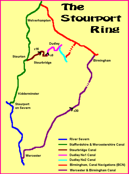
Stourport Ring
Encyclopedia
Canal
Canals are man-made channels for water. There are two types of canal:#Waterways: navigable transportation canals used for carrying ships and boats shipping goods and conveying people, further subdivided into two kinds:...
s forming a circuit, or canal ring
Canal ring
A canal ring is the name given to a series of canals that make a complete loop.-Origin of the Term:Whilst there have been canals which formed a ring for centuries, the ring terminology was unknown before the 1960s, when it was coined by the Inland Waterways Association as part of its campaign to...
, around Worcestershire
Worcestershire
Worcestershire is a non-metropolitan county, established in antiquity, located in the West Midlands region of England. For Eurostat purposes it is a NUTS 3 region and is one of three counties that comprise the "Herefordshire, Worcestershire and Warwickshire" NUTS 2 region...
, The Black Country and Birmingham
Birmingham
Birmingham is a city and metropolitan borough in the West Midlands of England. It is the most populous British city outside the capital London, with a population of 1,036,900 , and lies at the heart of the West Midlands conurbation, the second most populous urban area in the United Kingdom with a...
in central England
England
England is a country that is part of the United Kingdom. It shares land borders with Scotland to the north and Wales to the west; the Irish Sea is to the north west, the Celtic Sea to the south west, with the North Sea to the east and the English Channel to the south separating it from continental...
. The ring is formed from the River Severn
River Severn
The River Severn is the longest river in Great Britain, at about , but the second longest on the British Isles, behind the River Shannon. It rises at an altitude of on Plynlimon, Ceredigion near Llanidloes, Powys, in the Cambrian Mountains of mid Wales...
, the Staffordshire and Worcestershire Canal
Staffordshire and Worcestershire Canal
The Staffordshire and Worcestershire Canal is a narrow navigable canal in the English Midlands, passing through the counties of Staffordshire and Worcestershire....
, the Stourbridge Canal
Stourbridge Canal
The Stourbridge Canal is a canal in the West Midlands of England. It links the Staffordshire and Worcestershire Canal with the Dudley Canal, and hence, via the Birmingham Canal Navigations, to Birmingham and the Black Country.-History:The Stourbridge and Dudley canals were originally proposed as a...
, the Dudley Canal
Dudley Canal
The Dudley Canal is a canal passing though Dudley in the West Midlands of England. The canal is part of the English and Welsh connected network of navigable inland waterways, and in particular forms part of the popular Stourport Ring narrowboat cruising route....
s, the Birmingham Canal Navigations
Birmingham Canal Navigations
Birmingham Canal Navigations is a network of navigable canals connecting Birmingham, Wolverhampton, and the eastern part of the Black Country...
(Netherton Tunnel Branch Canal
Netherton Tunnel Branch Canal
Netherton Tunnel Branch Canal, in the English West Midlands, is part of the Birmingham Canal Navigations, . It was constructed at a 453–foot elevation, the Wednesbury or Birmingham level; it has no locks. The total length of the branch canal is and the canal tunnel is long.Netherton Tunnel was...
and Birmingham New Main Line
BCN Main Line
The BCN Main Line, or Birmingham Canal Navigations Main Line describes the evolving route of the Birmingham Canal between Birmingham and Wolverhampton in England....
) and the Worcester and Birmingham Canal
Worcester and Birmingham Canal
The Worcester and Birmingham Canal is a canal linking Birmingham and Worcester in England. It starts in Worcester, as an 'offshoot' of the River Severn and ends in Gas Street Basin in Birmingham. It is long....
.
The ring
Canal ring
A canal ring is the name given to a series of canals that make a complete loop.-Origin of the Term:Whilst there have been canals which formed a ring for centuries, the ring terminology was unknown before the 1960s, when it was coined by the Inland Waterways Association as part of its campaign to...
is 74 miles and includes 105 locks
Lock (water transport)
A lock is a device for raising and lowering boats between stretches of water of different levels on river and canal waterways. The distinguishing feature of a lock is a fixed chamber in which the water level can be varied; whereas in a caisson lock, a boat lift, or on a canal inclined plane, it is...
including 3 electrically operated river locks, 2 pairs of staircase locks and 2 broad locks. The route includes flights of locks at Tardebigge
Tardebigge Locks
Tardebigge Locks or the Tardebigge Flight is the longest flight of locks in the UK, comprising 30 narrow locks on a two and a quarter mile stretch of the Worcester and Birmingham Canal at Tardebigge, Worcestershire...
(x30), Stourbridge
Stourbridge
Stourbridge is a town within the Metropolitan Borough of Dudley, in the West Midlands of England. Historically part of Worcestershire, Stourbridge was a centre of glass making, and today includes the suburbs of Amblecote, Lye, Norton, Oldswinford, Pedmore, Wollaston, Wollescote and Wordsley The...
(x16) and the Black Delph at Brierley Hill (x8). The route also includes two of the longest navigable tunnels on the UK network, these being the Netherton
Netherton Tunnel Branch Canal
Netherton Tunnel Branch Canal, in the English West Midlands, is part of the Birmingham Canal Navigations, . It was constructed at a 453–foot elevation, the Wednesbury or Birmingham level; it has no locks. The total length of the branch canal is and the canal tunnel is long.Netherton Tunnel was...
and Wast Hills Tunnels.
The ring
Canal ring
A canal ring is the name given to a series of canals that make a complete loop.-Origin of the Term:Whilst there have been canals which formed a ring for centuries, the ring terminology was unknown before the 1960s, when it was coined by the Inland Waterways Association as part of its campaign to...
has an alternative longer route via Wolverhampton
Wolverhampton
Wolverhampton is a city and metropolitan borough in the West Midlands, England. For Eurostat purposes Walsall and Wolverhampton is a NUTS 3 region and is one of five boroughs or unitary districts that comprise the "West Midlands" NUTS 2 region...
of 83 miles and 122 locks and does not include the Stourbridge or Dudley canals. This route uses the connection between the Staffordshire and Worcestershire Canal
Staffordshire and Worcestershire Canal
The Staffordshire and Worcestershire Canal is a narrow navigable canal in the English Midlands, passing through the counties of Staffordshire and Worcestershire....
, and the BCN Main Line
BCN Main Line
The BCN Main Line, or Birmingham Canal Navigations Main Line describes the evolving route of the Birmingham Canal between Birmingham and Wolverhampton in England....
at Aldersley Junction
Aldersley Junction
Aldersley Junction is the name of the canal junction where the Birmingham Main Line Canal terminates and meets the Staffordshire and Worcestershire Canal near to Oxley, north Wolverhampton, West Midlands, England....
.
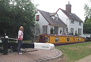
The ring is popular for cruising and has a number of narrowboat
Narrowboat
A narrowboat or narrow boat is a boat of a distinctive design, made to fit the narrow canals of Great Britain.In the context of British Inland Waterways, "narrow boat" refers to the original working boats built in the 18th, 19th, and 20th centuries for carrying goods on the narrow canals...
hire centres on the route including Alvechurch, Viking Afloat (Worcester), Anglo-Welsh (Tardebigge), Brook Line (Dunhampstead) and Black Prince (Stoke Prior).
Black Country Living Museum
The Black Country Living Museum is an open-air museum of rebuilt historic buildings, located in Dudley in the West Midlands of England. The museum occupies a urban heritage park in the shadow of Dudley Castle in the centre of the Black Country conurbation...
, the Severn Valley Railway
Severn Valley Railway
The Severn Valley Railway is a heritage railway in Shropshire and Worcestershire, England. The line runs along the Severn Valley from Bridgnorth to Kidderminster, following the course of the River Severn for much of its route...
, Kinver Edge
Kinver Edge
Kinver Edge is a high heath and woodland escarpment just west of Kinver, about four miles west of Stourbridge, and four miles north of Kidderminster, and is on the border between Worcestershire and Staffordshire, England. It is now owned by the National Trust....
, the Birmingham Jewellery Quarter
Jewellery Quarter
The Jewellery Quarter is an area of Birmingham City Centre, England, situated in the south of the Hockley area. It is covered by the Ladywood district. There is a population of around 3,000 people in a area....
, Brindleyplace
Brindleyplace
Brindleyplace is a large mixed-use canalside development, in the Westside district of Birmingham, England. It is often written erroneously as Brindley Place, the name of the street around which it is built...
plus the Merry Hill
Merry Hill Shopping Centre
Westfield Merry Hill is a shopping centre in Brierley Hill near Dudley, West Midlands, England. It was developed between 1985 and 1990, with several expansion and renovation projects taking place since. The original developers and owners were Richardson Developments but the Centre has had a number...
, Bullring
Bullring, Birmingham
The Bull Ring is a major commercial area of Birmingham, England. It has been an important feature of Birmingham since the Middle Ages, when its market was first held...
and Mailbox
The Mailbox
The Mailbox is an upmarket development of offices, designer shops, restaurants, bars and luxury city-centre apartments in the City Centre and on the boundary of the City Centre Core in Birmingham, West Midlands, England. It includes a mini supermarket and three art galleries: the Artlounge, Castle...
shopping centres.
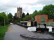
Popular overnight mooring places on the ring include Worcester
Worcester
The City of Worcester, commonly known as Worcester, , is a city and county town of Worcestershire in the West Midlands of England. Worcester is situated some southwest of Birmingham and north of Gloucester, and has an approximate population of 94,000 people. The River Severn runs through the...
city centre, Stourport Basin, Wolverley
Wolverley
Wolverley is a village, and with Cookley together, a civil parish in the Wyre Forest District of Worcestershire, England. It is located a few miles to the north west of Kidderminster, near the town of Bewdley, and the villages of Kinver and Cookley...
, Kinver
Kinver
Kinver is a large village in South Staffordshire district, Staffordshire, England. It is in the far south-west of the county, at the end of the narrow finger of land surrounded by the counties of Shropshire, Worcestershire and the West Midlands. The nearest towns are Stourbridge in the West...
, Merry Hill
Merry Hill Shopping Centre
Westfield Merry Hill is a shopping centre in Brierley Hill near Dudley, West Midlands, England. It was developed between 1985 and 1990, with several expansion and renovation projects taking place since. The original developers and owners were Richardson Developments but the Centre has had a number...
, Windmill End, The Black Country Museum
Black Country Living Museum
The Black Country Living Museum is an open-air museum of rebuilt historic buildings, located in Dudley in the West Midlands of England. The museum occupies a urban heritage park in the shadow of Dudley Castle in the centre of the Black Country conurbation...
(via short detour), Gas Street Basin
Gas Street Basin
Gas Street Basin is a canal basin in the centre of Birmingham, England, where the Worcester and Birmingham Canal meets the BCN Main Line. It is located on Gas Street, off Broad Street, and between the Mailbox and Brindleyplace canal-side developments....
, Hopwood
Hopwood, Worcestershire
Hopwood is a small settlement in Worcestershire, located south of Birmingham, England on the Worcester and Birmingham Canal. The settlement is developed around an inn, where users of the canal would have broken their journey....
, Stoke Works and Dunhampstead.
List of all locks on the ring with their map references
Based on travelling clockwise and starting at Worcester. Excludes the northern extension.| Lock Number | Waterway | Lock Name | Coordinates Geographic coordinate system A geographic coordinate system is a coordinate system that enables every location on the Earth to be specified by a set of numbers. The coordinates are often chosen such that one of the numbers represent vertical position, and two or three of the numbers represent horizontal position... |
OS Grid Ref British national grid reference system The Ordnance Survey National Grid reference system is a system of geographic grid references used in Great Britain, different from using latitude and longitude.... |
| 1 | River Severn | Bevere Lock | 52.2333°N 2.2407°W | |
| 2 | Holt Lock | |||
| 3 | Lincomb Lock | 52.3216°N 2.2646°W | ||
| 4/5 | Staffordshire and Worcestershire Canal | Stourport basin lower staircase | ||
| 6/7 | Stourport basin upper staircase | |||
| 8 | Stourport York Street Lock 3 | 52.3386°N 2.2787°W | ||
| 9 | Falling Sands Lock 4 | 52.3674°N 2.2548°W | ||
| 10 | Caldwell Lock 5 | 52.3783°N 2.2548°W | ||
| 11 | Kidderminster Lock 6 | |||
| 12 | Wolverley Court Lock 7 | 52.4031°N 2.2524°W | ||
| 13 | Wolverley Lock 8 | 52.4102°N 2.2497°W | ||
| 14 | Debdale Lock 9 | |||
| 15 | Whittington Lock 10 | 52.4406°N 2.2171°W | ||
| 16 | Kinver Lock 11 | |||
| 17 | Hyde Lock 12 | |||
| 18 | Stewponey Lock 13 | 52.4616°N 2.2059°W | ||
| 19 | Stourbridge Canal | Stourton Bottom Lock | 52.4636°N 2.2047°W | |
| 20 | Stourton Lock | |||
| 21 | Stourton Lock | |||
| 22 | Stourton Top Lock | 52.4646°N 2.1990°W | ||
| 23 | Stourbridge Bottom Lock 16 | 52.4728°N 2.1643°W | ||
| 24 | Stourbridge Lock 15 | |||
| 25 | Stourbridge Lock 14 | |||
| 26 | Stourbridge Lock 13 | |||
| 27 | Stourbridge Lock 12 | |||
| 28 | Stourbridge Lock 11 | |||
| 29 | Stourbridge Lock 10 | |||
| 30 | Stourbridge Lock 9 | |||
| 31 | Stourbridge Lock 8 | |||
| 32 | Stourbridge Lock 7 | |||
| 33 | Stourbridge Lock 6 | |||
| 34 | Stourbridge Lock 5 | |||
| 35 | Stourbridge Lock 4 | |||
| 36 | Stourbridge Lock 3 | |||
| 37 | Stourbridge Lock 2 | |||
| 38 | Stourbridge Top Lock 1 | 52.4829°N 2.1436°W | ||
| 39 | Dudley Canal Line No. 1 | Delph Bottom Lock 8 | 52.4756°N 2.1230°W | |
| 40 | Delph Lock 7 | |||
| 41 | Delph Lock 6 | |||
| 42 | Delph Lock 5 | |||
| 43 | Delph Lock 4 | |||
| 44 | Delph Lock 3 | |||
| 45 | Delph Lock 2 | |||
| 46 | Delph Top Lock 1 | 52.4790°N 2.1184°W | ||
| 47 | Blowers Green Lock* | |||
| Dudley Canal Line No. 2 | (no locks) | |||
| Netherton Tunnel Branch Canal | (no locks) | |||
| Birmingham New Main Line | (no locks) | |||
| 48 | Worcester and Birmingham Canal | Tardebigge Top Lock No 58* | 52.3214°N 2.0107°W | |
| 49 | Tardebigge Lock No 57 | |||
| 50 | Tardebigge Lock No 56 | |||
| 51 | Tardebigge Lock No 55 | |||
| 52 | Tardebigge Lock No 54 | |||
| 53 | Tardebigge Lock No 53 | |||
| 54 | Tardebigge Lock No 52 | |||
| 55 | Tardebigge Lock No 51 | |||
| 56 | Tardebigge Lock No 50 | |||
| 57 | Tardebigge Lock No 49 | |||
| 58 | Tardebigge Lock No 48 | |||
| 59 | Tardebigge Lock No 47 | |||
| 60 | Tardebigge Lock No 46 | |||
| 61 | Tardebigge Lock No 45 | |||
| 62 | Tardebigge Lock No 44 | |||
| 63 | Tardebigge Lock No 43 | |||
| 64 | Tardebigge Lock No 42 | |||
| 65 | Tardebigge Lock No 41 | |||
| 66 | Tardebigge Lock No 40 | |||
| 67 | Tardebigge Lock No 39 | |||
| 68 | Tardebigge Lock No 38 | |||
| 69 | Tardebigge Lock No 37 | |||
| 70 | Tardebigge Lock No 36 | |||
| 71 | Tardebigge Lock No 35 | |||
| 72 | Tardebigge Lock No 34 | |||
| 73 | Tardebigge Lock No 33 | |||
| 74 | Tardebigge Lock No 32 | |||
| 75 | Tardebigge Lock No 31 | |||
| 76 | Tardebigge Lock No 30 | |||
| 77 | Tardebigge Bottom Lock No 29 | 52.3099°N 2.0542°W | ||
| 78 | Stoke Top Lock No 28 | |||
| 79 | Stoke Lock No 27 | |||
| 80 | Stoke Lock No 26 | |||
| 81 | Stoke Lock No 25 | |||
| 82 | Stoke Lock No 24 | |||
| 83 | Stoke Prior Bottom Lock No 23 | |||
| 84 | Astwood Top Lock No 22 | |||
| 85 | Astwood Lock No 21 | |||
| 86 | Astwood Lock No 20 | |||
| 87 | Astwood Lock No 19 | |||
| 88 | Astwood Lock No 18 | |||
| 89 | Astwood Bottom Lock No 17 | |||
| 90 | Offerton Top Lock No 16 | |||
| 91 | Offerton Lock No 15 | |||
| 92 | Offerton Lock No 14 | |||
| 93 | Offerton Lock No 13 | |||
| 94 | Offerton Lock No 12 | |||
| 95 | Offerton Bottom Lock No 11 | |||
| 96 | Tolladine Lock No 10 | |||
| 97 | Blackpole Lock No 9 | |||
| 98 | Bilford Top Lock | |||
| 99 | Bilford Bottom Lock | |||
| 100 | Gregory's Mill Top Lock | |||
| 101 | Gregory's Mill Bottom Lock | |||
| 102 | Blockhouse Lock No 4 | |||
| 103 | Sidbury Lock No 3 | |||
| 104 | Diglis Lock No 2 | |||
| 105 | Diglis Lock No 1 | 52.1777°N 2.2253°W |
- From Blowers Green to Tardebigge top lock, the ring is at the Birmingham Summit level.