
.gif)
State Route 18 (Washington)
Encyclopedia
State Route 18, also known as SR 18 or Highway 18, is a 28 miles (45.1 km) long state highway in the U.S. state
of Washington, which connects State Route 99
in south King County with Interstate 90
. It runs northeast from Federal Way, through Auburn, south Kent, Covington, Maple Valley, over the 1375 ft (419.1 m) Tiger Summit
, and then terminates at I-90 about 8 miles (12.9 km) east of Issaquah
near Snoqualmie. This highway is the most direct route between Eastern Washington
and Tacoma. North of I-90, Highway 18 becomes a local arterial, Snoqualmie Parkway. Snoqualmie Parkway continues to SR 202 just east of Snoqualmie Falls
. This is the shortest route between I-90 and attractions at Snoqualmie Falls.
Highway 18 is a dangerous roadway due in part to the heavy truck traffic between I-5 and I-90. For the past several years, work has been done on a project to turn SR 18 into a limited access highway and widen it to four lanes, two in each direction. Three-fourths of the highway upgrade has been completed; it now has four lanes from Federal Way to Issaquah Hobart Road. The last one-fourth of the expansion is 7 miles (11.3 km) which includes the climb up to Tiger Summit and the last 2 miles (3.2 km) to Interstate 90 with a freeway-to-freeway connection. The project still needs $267.5 million in funding and construction is set to be completed by 2015.
SR 18 forms part of one possible route for a proposed future Interstate 605
, though the idea faces considerable opposition. However, some argue for renumbering the highway as an Interstate highway after completion of the widening, since it links Interstate 5 to Interstate 90.
(Pacific Highway). Heading due east, SR 18 comes to a second traffic light
at SR 161
(16th Avenue South / Enchanted Parkway), providing access to Federal Way
and Wild Waves Theme Park. SR 18 becomes a full freeway and the first grade separated interchange is a full cloverleaf interchange
with Interstate 5
(I-5), providing access to Seattle
and Vancouver, British Columbia to the north, and Tacoma
and Portland, Oregon
to the south. A diamond interchange
with Weyerhaeuser Way reduces the number of lanes to two each direction as the highway descends into Peasley Canyon.
After exiting the canyon, a complex hybrid partial cloverleaf interchange / diamond interchange with the West Valley Highway (former SR 181
) and an almost complete cloverleaf interchange SR 167 occurs, with traffic from eastbound SR 18 only being able to access SR 167 via the West Valley Highway. This interchange is the highest traffic point on SR 18, with a daily average
of 88,000 cars-per-day traveling along SR 18 at this interchange (a slight decrease from 93,000 in 2007, and 89,000 in 2006). Traffic has more than sextupled since 1967, the first entry for SR 18 in the annual traffic log, with only 14,500 cars-per-day passing through this intersection. The SuperMall of the Great Northwest
, which has direct access ramps onto SR 167 and SR 18 passes to the south of SR 18. Union Pacific Railroad
, former Northern Pacific Railroad, tracks and the mixed-use Interurban Trail
pass underneath SR 18 as it approaches a folded cloverleaf interchange with C Street Southwest in Auburn
. SR 164
(Auburn Way South) is accessible by a partial cloverleaf / diamond interchange, and is the final exit with in Auburn.
Another folded cloverleaf interchange provides access to Green River Community College
, Auburn Narrows Park and Hatchery Park via Southeast Auburn-Black Diamond Road. The highway passes over the Green River
and parallels Big Soos Creek as it climbs into an interchange with Southeast 304th Street in unincorporated King County
. Entering Covington
, SR 18 intersects SR 516
(Southeast 272nd Street / Kent Kangley Road). 180th Avenue Southeast (Souheast Wax Road) is the next interchange before SR 18 passes over Jenkins Creek, and then an interchange with Southeast 256th Street.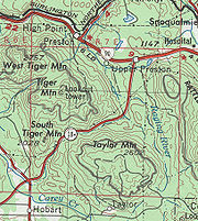 A diamond interchange provides access to Maple Valley
before the route continues northerly and crosses over the Cedar River
and through an interchange with 244th Avenue Southeast. An overpass, carrying Southeast 200th Street, use to be a signalized at-grade intersection before the reconstruction of SR 18, passes over the highway as it approaches the Issaquah-Hobart Road serving the cities of Issaquah
and Hobart
as well as the Mirrormont residential community between Issaquah and SR 18 at the base of Tiger Mountain.
SR 18 becomes an at-grade roadway again, and climbs towards the summit of Tiger Mountain with an interchange at the summit with a parking area to the north of the highway that allows access to a trail head that leads to a hang gliding point. Continuing down the summit the highway passes over the Raging River
and Lake Creek before an at-grade interchange with Southeast 104th Street (Rattlesnake Road SE). The final interchange of SR 18 is a fully signalized diamond interchange with I-90
, providing access to Issaquah and Seattle to the west and North Bend
and Spokane
to the east. The roadway continues past the interchange as Snoqualmie Parkway where it terminates at SR 202 in Snoqualmie
.
wrote a song entitled Midnight Highway which sings "I miss our midnight rides on highway 18, 18 is gone."
U.S. state
A U.S. state is any one of the 50 federated states of the United States of America that share sovereignty with the federal government. Because of this shared sovereignty, an American is a citizen both of the federal entity and of his or her state of domicile. Four states use the official title of...
of Washington, which connects State Route 99
Washington State Route 99
State Route 99, abbreviated SR 99, commonly called Highway 99, is a numbered state highway in the U.S. state of Washington extending just under from Fife in the south to Everett in the north, with a gap in Tukwila.-Southern division:...
in south King County with Interstate 90
Interstate 90 in Washington
Interstate 90 , a transcontinental Interstate Highway from Seattle, Washington, to Boston, Massachusetts, crosses the state of Washington before crossing the Idaho state line between Spokane and Post Falls...
. It runs northeast from Federal Way, through Auburn, south Kent, Covington, Maple Valley, over the 1375 ft (419.1 m) Tiger Summit
Tiger Mountain
Tiger Mountain is a mountain in the U.S. state of Washington.-The mountain:The mountain has six peaks in the center of the Issaquah Alps forming a triangle between Interstate 90 on the north, the Issaquah-Hobart Road on the southwest, and State Route 18 on the southeast...
, and then terminates at I-90 about 8 miles (12.9 km) east of Issaquah
Issaquah, Washington
Issaquah is a city in King County, Washington, United States. The population was 30,434 at the 2010 census.Based on per capita income, Issaquah ranks 25th of 522 areas in the State of Washington to be ranked....
near Snoqualmie. This highway is the most direct route between Eastern Washington
Eastern Washington
Eastern Washington is the portion of the U.S. state of Washington east of the Cascade Range. The region contains the city of Spokane , the Tri-Cities, the Columbia River and the Grand Coulee Dam, the Hanford Nuclear Reservation and the fertile farmlands of the Yakima Valley and the...
and Tacoma. North of I-90, Highway 18 becomes a local arterial, Snoqualmie Parkway. Snoqualmie Parkway continues to SR 202 just east of Snoqualmie Falls
Snoqualmie Falls
Snoqualmie Falls is a 268 ft waterfall on the Snoqualmie River between Snoqualmie and Fall City, Washington, USA. It is one of Washington's most popular scenic attractions, but is perhaps best known internationally for its appearance in the cult television series Twin Peaks...
. This is the shortest route between I-90 and attractions at Snoqualmie Falls.
Highway 18 is a dangerous roadway due in part to the heavy truck traffic between I-5 and I-90. For the past several years, work has been done on a project to turn SR 18 into a limited access highway and widen it to four lanes, two in each direction. Three-fourths of the highway upgrade has been completed; it now has four lanes from Federal Way to Issaquah Hobart Road. The last one-fourth of the expansion is 7 miles (11.3 km) which includes the climb up to Tiger Summit and the last 2 miles (3.2 km) to Interstate 90 with a freeway-to-freeway connection. The project still needs $267.5 million in funding and construction is set to be completed by 2015.
SR 18 forms part of one possible route for a proposed future Interstate 605
Interstate 605 (Washington)
Interstate 605 is the common designation given to several proposals for a new auxiliary route of the Interstate Highway System bypassing Interstate 5 and I-405 in the US state of Washington. Proposals have been heard from since the 1960s, including highways connecting from I-5 all the way to the...
, though the idea faces considerable opposition. However, some argue for renumbering the highway as an Interstate highway after completion of the widening, since it links Interstate 5 to Interstate 90.
Route description
Washington State Route 18 (SR 18) begins as South 348th Street at a signalized interchange with SR 99Washington State Route 99
State Route 99, abbreviated SR 99, commonly called Highway 99, is a numbered state highway in the U.S. state of Washington extending just under from Fife in the south to Everett in the north, with a gap in Tukwila.-Southern division:...
(Pacific Highway). Heading due east, SR 18 comes to a second traffic light
Traffic light
Traffic lights, which may also be known as stoplights, traffic lamps, traffic signals, signal lights, robots or semaphore, are signalling devices positioned at road intersections, pedestrian crossings and other locations to control competing flows of traffic...
at SR 161
Washington State Route 161
State Route 161, known as Enchanted Parkway within King County and as Meridian within most of Pierce County, is a numbered state highway in the state of Washington, U.S.A...
(16th Avenue South / Enchanted Parkway), providing access to Federal Way
Federal Way, Washington
Federal Way is a city in King County, Washington, United States. Federal Way is located between Seattle and Tacoma. Its western boundary is Puget Sound. It is bordered by Des Moines on the north, Kent, unincorporated King County, and Milton on the east and Tacoma and Fife on the south...
and Wild Waves Theme Park. SR 18 becomes a full freeway and the first grade separated interchange is a full cloverleaf interchange
Cloverleaf interchange
A cloverleaf interchange is a two-level interchange in which left turns, reverse direction in left-driving regions, are handled by ramp roads...
with Interstate 5
Interstate 5 in Washington
Interstate 5 in Washington is a highway in the U.S. state of Washington that extends from its border with Oregon to its border with Canada...
(I-5), providing access to Seattle
Seattle, Washington
Seattle is the county seat of King County, Washington. With 608,660 residents as of the 2010 Census, Seattle is the largest city in the Northwestern United States. The Seattle metropolitan area of about 3.4 million inhabitants is the 15th largest metropolitan area in the country...
and Vancouver, British Columbia to the north, and Tacoma
Tacoma, Washington
Tacoma is a mid-sized urban port city and the county seat of Pierce County, Washington, United States. The city is on Washington's Puget Sound, southwest of Seattle, northeast of the state capital, Olympia, and northwest of Mount Rainier National Park. The population was 198,397, according to...
and Portland, Oregon
Portland, Oregon
Portland is a city located in the Pacific Northwest, near the confluence of the Willamette and Columbia rivers in the U.S. state of Oregon. As of the 2010 Census, it had a population of 583,776, making it the 29th most populous city in the United States...
to the south. A diamond interchange
Diamond interchange
A diamond interchange is a common type of road junction, used where a freeway crosses a minor road. The freeway itself is grade-separated from the minor road, one crossing the other over a bridge...
with Weyerhaeuser Way reduces the number of lanes to two each direction as the highway descends into Peasley Canyon.
After exiting the canyon, a complex hybrid partial cloverleaf interchange / diamond interchange with the West Valley Highway (former SR 181
Washington State Route 181
State Route 181 is a state highway in the U.S. state of Washington. It is long, and runs from State Route 516 in Kent in the south to Interstate 405 in Tukwila in the north...
) and an almost complete cloverleaf interchange SR 167 occurs, with traffic from eastbound SR 18 only being able to access SR 167 via the West Valley Highway. This interchange is the highest traffic point on SR 18, with a daily average
Annual average daily traffic
Average Annual daily traffic, abbreviated AADT, is a measure used primarily in transportation planning and transportation engineering. It is the total volume of vehicle traffic of a highway or road for a year divided by 365 days. AADT is a useful and simple measurement of how busy the road is...
of 88,000 cars-per-day traveling along SR 18 at this interchange (a slight decrease from 93,000 in 2007, and 89,000 in 2006). Traffic has more than sextupled since 1967, the first entry for SR 18 in the annual traffic log, with only 14,500 cars-per-day passing through this intersection. The SuperMall of the Great Northwest
SuperMall of the Great Northwest
SuperMall of the Great Northwest is an indoor hybrid mall that originally opened in 1995 as the Northwest's largest outlet mall located in Auburn, Washington. The original anchors included Nordstrom Rack, Bed Bath and Beyond, Gart Sports, Burlington Coat Factory, Marshalls, and Incredible Universe...
, which has direct access ramps onto SR 167 and SR 18 passes to the south of SR 18. Union Pacific Railroad
Union Pacific Railroad
The Union Pacific Railroad , headquartered in Omaha, Nebraska, is the largest railroad network in the United States. James R. Young is president, CEO and Chairman....
, former Northern Pacific Railroad, tracks and the mixed-use Interurban Trail
Interurban Trail (King County)
The Interurban Trail is a rail trail in King County, Washington.It is a partially paved recreational trail open for non-motorized use. It connects Tukwila to Pacific, and the towns of Kent, Auburn, and Algona along the way....
pass underneath SR 18 as it approaches a folded cloverleaf interchange with C Street Southwest in Auburn
Auburn, Washington
-Parks:Auburn has an extensive system of parks, open space and urban trails comprising 29 developed parks, 5 undeveloped sites under planning, 2 skate parks, 2 water roatary parks, and over of trails , and almost of open space for passive and active recreation.-Environmental Park:The Auburn...
. SR 164
Washington State Route 164
State Route 164 is a long state highway located entirely with in King County, Washington, United States. The highway travels from SR 18 in Auburn to SR 410 in Enumclaw.- Route description :...
(Auburn Way South) is accessible by a partial cloverleaf / diamond interchange, and is the final exit with in Auburn.
Another folded cloverleaf interchange provides access to Green River Community College
Green River Community College
Green River Community College is a community college located in Auburn, Washington, USA. It has a student body of approximately 10,000.-History:...
, Auburn Narrows Park and Hatchery Park via Southeast Auburn-Black Diamond Road. The highway passes over the Green River
Green River (Washington)
The Green River is a long river in the state of Washington in the United States, arising on the western slopes of the Cascade Mountains south of I-90....
and parallels Big Soos Creek as it climbs into an interchange with Southeast 304th Street in unincorporated King County
King County, Washington
King County is a county located in the U.S. state of Washington. The population in the 2010 census was 1,931,249. King is the most populous county in Washington, and the 14th most populous in the United States....
. Entering Covington
Covington, Washington
Covington is a city in King County, Washington, United States. The population was 17,575 at the time of the 2010 census. Prior to the 2010 census, Covington was counted as part of Covington-Sawyer-Wilderness CDP.-History:...
, SR 18 intersects SR 516
Washington State Route 516
State Route 516, abbreviated SR 516, is a state route in the U.S. state of Washington, with a western terminus at Marine View Dr. S in Des Moines and an eastern terminus at State Route 169.-Route description:...
(Southeast 272nd Street / Kent Kangley Road). 180th Avenue Southeast (Souheast Wax Road) is the next interchange before SR 18 passes over Jenkins Creek, and then an interchange with Southeast 256th Street.
Maple Valley, Washington
Maple Valley is a city in King County, Washington, United States. The population was 22,684 at the 2010 census.-History:The area was first settled in 1879 by three men who were improving a trail and brought their families in. When a name for a future community was proposed, the names Vine Maple...
before the route continues northerly and crosses over the Cedar River
Cedar River (Washington)
The Cedar River is a river in the U.S. state of Washington. About long, it originates in the Cascade Range and flows generally west and northwest, emptying into the southern end of Lake Washington...
and through an interchange with 244th Avenue Southeast. An overpass, carrying Southeast 200th Street, use to be a signalized at-grade intersection before the reconstruction of SR 18, passes over the highway as it approaches the Issaquah-Hobart Road serving the cities of Issaquah
Issaquah, Washington
Issaquah is a city in King County, Washington, United States. The population was 30,434 at the 2010 census.Based on per capita income, Issaquah ranks 25th of 522 areas in the State of Washington to be ranked....
and Hobart
Hobart, Washington
Hobart is a census-designated place in King County, Washington, United States. The population was 6,221 at the 2010 census.Based on per capita income, one of the more reliable measures of affluence, Hobart ranks 31st of 522 areas in the state of Washington to be ranked.-Geography:Hobart is located...
as well as the Mirrormont residential community between Issaquah and SR 18 at the base of Tiger Mountain.
SR 18 becomes an at-grade roadway again, and climbs towards the summit of Tiger Mountain with an interchange at the summit with a parking area to the north of the highway that allows access to a trail head that leads to a hang gliding point. Continuing down the summit the highway passes over the Raging River
Raging River
The Raging River is a modest tributary to the much larger Snoqualmie River in western Washington State in the United States. It is located in the western foothills of the Cascade Mountains in east central King County, Washington. It gets its name from the large amount of water is sometimes carries...
and Lake Creek before an at-grade interchange with Southeast 104th Street (Rattlesnake Road SE). The final interchange of SR 18 is a fully signalized diamond interchange with I-90
Interstate 90 in Washington
Interstate 90 , a transcontinental Interstate Highway from Seattle, Washington, to Boston, Massachusetts, crosses the state of Washington before crossing the Idaho state line between Spokane and Post Falls...
, providing access to Issaquah and Seattle to the west and North Bend
North Bend, Washington
North Bend is a city in King County, Washington, United States. The town was made famous by David Lynch's television series Twin Peaks Since the Weyerhaeuser sawmill closed, North Bend has become an upscale bedroom community for the Eastside of Seattle, Washington, with property values more than...
and Spokane
Spokane, Washington
Spokane is a city located in the Northwestern United States in the state of Washington. It is the largest city of Spokane County of which it is also the county seat, and the metropolitan center of the Inland Northwest region...
to the east. The roadway continues past the interchange as Snoqualmie Parkway where it terminates at SR 202 in Snoqualmie
Snoqualmie, Washington
Snoqualmie is a city next to Snoqualmie Falls in King County, Washington. The city is home to the Northwest Railway Museum. The population was of 10,670 at the 2010 census...
.
Exit list
The entire route is in King County.| Location | Mile | Destinations | Notes |
|---|---|---|---|
| Federal Way Federal Way, Washington Federal Way is a city in King County, Washington, United States. Federal Way is located between Seattle and Tacoma. Its western boundary is Puget Sound. It is bordered by Des Moines on the north, Kent, unincorporated King County, and Milton on the east and Tacoma and Fife on the south... |
0.00 | ||
| 0.21 | |||
| West end of freeway | |||
| 0.52 | , Portland | ||
| 1.30 | Weyerhaeuser Way South | ||
| Auburn Auburn, Washington -Parks:Auburn has an extensive system of parks, open space and urban trails comprising 29 developed parks, 5 undeveloped sites under planning, 2 skate parks, 2 water roatary parks, and over of trails , and almost of open space for passive and active recreation.-Environmental Park:The Auburn... |
3.21 | West Valley Highway | Former SR 181 Washington State Route 181 State Route 181 is a state highway in the U.S. state of Washington. It is long, and runs from State Route 516 in Kent in the south to Interstate 405 in Tukwila in the north... |
| 3.40 | Eastbound exit to SR 167 south is via West Valley Highway | ||
| 4.35 | C Street Southwest | ||
| 4.68 | |||
| 6.94 | Auburn-Black Diamond Road | ||
| 9.30 | Southeast 304th Street, Southeast 312th Street | ||
| Covington Covington, Washington Covington is a city in King County, Washington, United States. The population was 17,575 at the time of the 2010 census. Prior to the 2010 census, Covington was counted as part of Covington-Sawyer-Wilderness CDP.-History:... |
11.97 | ||
| 13.65 | Southeast 256th Street | ||
| 16.22 | |||
| 18.49 | 244th Avenue Southeast | ||
| 20.84 | Issaquah, Hobart | ||
| East end of freeway | |||
| 24.11 | Tiger Mountain State Forest | ||
| 28.41 | Interchange | ||
| 28.41 | Snoqualmie Parkway | Continuation beyond I-90 to SR 202 | |
Cultural references
A band local to the Kent/Covington/Auburn area called Daphne Loves DerbyDaphne Loves Derby
Daphne Loves Derby is an American Indie rock band that formed in Kent, Washington, in 2001. They have released three studio albums, the third in 2007 titled Good Night, Witness Light, peaked at number 30 on the Billboard Top Heatseekers chart...
wrote a song entitled Midnight Highway which sings "I miss our midnight rides on highway 18, 18 is gone."
Related routes
- State Route 181, an auxiliary route that use to connect to SR 18, and is considered a child route of SR 18.