

Washington State Route 99
Encyclopedia
State Route 99, abbreviated SR 99, commonly called Highway 99, is a numbered state highway
in the U.S. state
of Washington extending just under 50 miles (80.5 km) from Fife
in the south to Everett
in the north, with a 2 miles (3.2 km) gap in Tukwila
.
, near its own intersection with 54th Avenue E. From there, it heads eastward to Federal Way
where it becomes Pacific Highway South and intersects SR 18
just west of its interchange with I-5. It then begins to travel north, through Des Moines
, overlapping SR 509
for a few miles. The route becomes a little difficult to identify for several miles, as there are no reassurance signs until entering SeaTac
. Once there, it becomes International Boulevard and forms the eastern boundary of the Seattle-Tacoma International Airport
until crossing SR 518
, where the southern division ends.
 The northern division begins where the freeway carrying SR 599 northward passes over International Boulevard South. SR 599 terminates at that point; north of there, it becomes SR 99. SR 99 continues north to an interchange with SR 509 and West Marginal Way at the southern end of the First Avenue South Bridge
. SR 99 crosses over the bridge and onto East Marginal Way, a surface street passing through the industrial and warehouse district of south Seattle known as Sodo
. Near Spokane Street and the eastern end of the West Seattle Bridge
, SR 99 again becomes a freeway. A portion travels on the surface before the route rises onto the Alaskan Way Viaduct
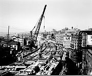
, which traverses the downtown Seattle waterfront. The viaduct terminates at the Battery Street Tunnel, which runs for 3140 feet (957.1 m) underneath Battery Street. The tunnel carries SR 99 underneath the Belltown neighborhood of Seattle and onto Aurora Avenue North.
The tunnel was built in 1952 using the cut-and-cover method. It carries two traffic lanes in each direction, and connects the Alaskan Way Viaduct
to Aurora Avenue N., providing continuity for State Route 99. There are no sidewalks or other provisions for pedestrians or bicyclists in the Tunnel. When an incident blocking traffic takes place within the tunnel, warning lights advise motorists to exit SR-99 at Western Avenue (northbound) and Denny Way (southbound). Emergency exits are placed behind sliding doors, with stairways leading up to Battery Street on the surface. Plans to renovate the Battery Street Tunnel to meet current ventilation and safety standards are on hold as of August 2008 due to financial and other considerations.
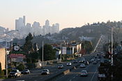
Aurora Avenue at this point is lined with businesses, residences, side streets and sidewalks. There is a median barrier, so cross traffic and left turns are not available; access is right-in/right-out
(RIRO) only. There are also several pedestrian overpasses and underpasses along this route. As Aurora Avenue nears and passes along the east flank of Queen Anne Hill
, the median barrier ends, although access remains RIRO. Aurora Avenue then crosses the Lake Washington Ship Canal
on the George Washington Memorial Bridge
(1932). At the interchange for Bridge Way, a very low median barrier begins, rising to a higher wall a bit north of North 38th Street. The barrier lowers again just beyond North 49th Street. Aurora Avenue then bisects Woodland Park
, with the barrier replaced by paint stripes until the next side street, North 59th. The higher wall resumes as Aurora Avenue approaches the northbound entrance from Green Lake Way. Just north of North 68th Street, there is a traffic light-controlled crosswalk across Aurora Avenue through a narrow break in the median. RIRO access ends and cross traffic resumes just before Winona Avenue North, which is the first traffic light-controlled intersection on Aurora Avenue. Aurora Avenue continues northward to 145th Street, which intersection is also the west terminus of SR 523. At that point, SR 99 leaves Seattle and enters Shoreline
as it continues northward on Aurora Avenue. SR 99 and Aurora Avenue crosses a former Interurban
Railway right-of-way, now an urban trail, near North 155th Street. It then continues north to the King County
- Snohomish County
line, which consists of a street marked North 205th Street in King County and 244th Street Southwest in Snohomish County.
Upon entering Snohomish County
and the city of Edmonds
, the highway changes names to Pacific Highway North and crosses interchange with SR 104. The highway continues north into Edmonds. North of Edmonds, SR 99 enters Lynnwood
, where it is known as Highway 99. SR 99 intersects SR 524 at 196th Street Southwest. SR 99 intersects SR 525 (known as the Mukilteo Speedway) at a partial interchange near Serene Lake. This interchange marks the northern end of the SR 525 freeway, which is an extension of Interstate 405
.
After a journey through Lynnwood, SR 99 enters Everett
, where it becomes known as Evergreen Way, until 3 miles (4.8 km) south of its terminus. At an intersection of Evergreen Way and Everett Mall Way, SR 99 goes northeast on Everett Mall Way. SR 99 passes the Mall near its interchange/intersection with Interstate 5, SR 526, and SR 527.
Before the completion of Interstate 5, SR 99 used to follow Evergreen Way onto Everett Mall Way (then known as "The Broadway Cut-Off") to Broadway; it then continued northbound through downtown Everett on Broadway. As Evergreen Way continues north in Everett, it becomes Rucker Avenue just south of 41st Street. Rucker Avenue intersects the former alignment of SR 526 at 41st Street.
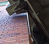 Near the northern terminus of the Alaskan Way Viaduct
, the southbound section of the viaduct is cut away to make room for a brick building that was there at the time of construction. This provides an interesting visual; although the structure of the building extends only a few inches into the viaduct, it is nonetheless unusual to see part of a building in the road, on a bridge, 50 ft (15.2 m) in the air.
State highway
State highway, state road or state route can refer to one of three related concepts, two of them related to a state or provincial government in a country that is divided into states or provinces :#A...
in the U.S. state
U.S. state
A U.S. state is any one of the 50 federated states of the United States of America that share sovereignty with the federal government. Because of this shared sovereignty, an American is a citizen both of the federal entity and of his or her state of domicile. Four states use the official title of...
of Washington extending just under 50 miles (80.5 km) from Fife
Fife, Washington
Fife is a city in Pierce County, Washington, United States. The population was 9,173 at the 2010 census.-History:In 1940, it was described as "Fife...at a valley crossroads in the midst of a thickly settled berry growing and truck-gardening district is represented by a string of markets, taverns,...
in the south to Everett
Everett, Washington
Everett is the county seat of and the largest city in Snohomish County, Washington, United States. Named for Everett Colby, son of founder Charles L. Colby, it lies north of Seattle. The city had a total population of 103,019 at the 2010 census, making it the 6th largest in the state and...
in the north, with a 2 miles (3.2 km) gap in Tukwila
Tukwila, Washington
Tukwila is a city in King County, Washington, United States. The northern edge of Tukwila borders the city of Seattle. The population was 19,107 at the 2010 census.-History:...
.
Southern division
SR 99 originates at Interstate 5 in FifeFife, Washington
Fife is a city in Pierce County, Washington, United States. The population was 9,173 at the 2010 census.-History:In 1940, it was described as "Fife...at a valley crossroads in the midst of a thickly settled berry growing and truck-gardening district is represented by a string of markets, taverns,...
, near its own intersection with 54th Avenue E. From there, it heads eastward to Federal Way
Federal Way, Washington
Federal Way is a city in King County, Washington, United States. Federal Way is located between Seattle and Tacoma. Its western boundary is Puget Sound. It is bordered by Des Moines on the north, Kent, unincorporated King County, and Milton on the east and Tacoma and Fife on the south...
where it becomes Pacific Highway South and intersects SR 18
State Route 18 (Washington)
State Route 18, also known as SR 18 or Highway 18, is a long state highway in the U.S. state of Washington, which connects State Route 99 in south King County with Interstate 90. It runs northeast from Federal Way, through Auburn, south Kent, Covington, Maple Valley, over the Tiger Summit, and...
just west of its interchange with I-5. It then begins to travel north, through Des Moines
Des Moines, Washington
Des Moines is a city in King County, Washington, United States. The population was 29,673 at the 2010 census. Property within the city has been the subject of land buyouts because of noise from aircraft landing or taking off from the Seattle-Tacoma International Airport two miles to the north of...
, overlapping SR 509
State Route 509 (Washington)
State Route 509 is a state highway in the U.S. state of Washington. It extends just over 35 miles from Tacoma in the south to Seattle in the north.-Route description:...
for a few miles. The route becomes a little difficult to identify for several miles, as there are no reassurance signs until entering SeaTac
SeaTac, Washington
SeaTac is an American city in southern King County, Washington, and an outlying suburb of Seattle, Washington. Incorporated in February 1990, the City of SeaTac is ten square miles in area and has a population of 26,909 according to the 2010 census...
. Once there, it becomes International Boulevard and forms the eastern boundary of the Seattle-Tacoma International Airport
Seattle-Tacoma International Airport
The Seattle–Tacoma International Airport , also known as Sea–Tac Airport or Sea–Tac , is an American airport located in SeaTac, Washington, at the intersections of State Routes 99 and 509 and 518, about west of Interstate 5...
until crossing SR 518
State Route 518 (Washington)
State Route 518 is a state highway in the U.S. state of Washington. It extends just under 3.5 miles from Burien in the west to Tukwila in the east.-Route description:...
, where the southern division ends.
Northern division
First Avenue South Bridge
The First Avenue South Bridge is a pair of double-leaf bascule bridges built between 1956 and 1998 that carry State Route 99 over the Duwamish River about three miles south of downtown Seattle, Washington....
. SR 99 crosses over the bridge and onto East Marginal Way, a surface street passing through the industrial and warehouse district of south Seattle known as Sodo
SoDo, Seattle, Washington
SoDo is a neighborhood in Seattle, Washington, that makes up part of the city's Industrial District. It is bounded on the north by South King Street, beyond which is Pioneer Square; on the south by South Spokane Street, beyond which is more of the Industrial District; on the west by the Duwamish...
. Near Spokane Street and the eastern end of the West Seattle Bridge
West Seattle Bridge
The high-level West Seattle Bridge is a cantilevered segmental bridge that serves as the primary connection between West Seattle and the rest of the city. It was built between 1981 and 1984 after the previous bascule bridge was deemed inoperable as a result of being struck by the Chavez freighter...
, SR 99 again becomes a freeway. A portion travels on the surface before the route rises onto the Alaskan Way Viaduct
Alaskan Way Viaduct
The Alaskan Way Viaduct, completed on April 4, 1953, is a double-decked elevated section of State Route 99 that runs along the Elliott Bay waterfront in Seattle's Industrial District and downtown Seattle. It is the smaller of the two major north–south traffic corridors through Seattle ,...
, which traverses the downtown Seattle waterfront. The viaduct terminates at the Battery Street Tunnel, which runs for 3140 feet (957.1 m) underneath Battery Street. The tunnel carries SR 99 underneath the Belltown neighborhood of Seattle and onto Aurora Avenue North.
The tunnel was built in 1952 using the cut-and-cover method. It carries two traffic lanes in each direction, and connects the Alaskan Way Viaduct
Alaskan Way Viaduct
The Alaskan Way Viaduct, completed on April 4, 1953, is a double-decked elevated section of State Route 99 that runs along the Elliott Bay waterfront in Seattle's Industrial District and downtown Seattle. It is the smaller of the two major north–south traffic corridors through Seattle ,...
to Aurora Avenue N., providing continuity for State Route 99. There are no sidewalks or other provisions for pedestrians or bicyclists in the Tunnel. When an incident blocking traffic takes place within the tunnel, warning lights advise motorists to exit SR-99 at Western Avenue (northbound) and Denny Way (southbound). Emergency exits are placed behind sliding doors, with stairways leading up to Battery Street on the surface. Plans to renovate the Battery Street Tunnel to meet current ventilation and safety standards are on hold as of August 2008 due to financial and other considerations.
Aurora Avenue at this point is lined with businesses, residences, side streets and sidewalks. There is a median barrier, so cross traffic and left turns are not available; access is right-in/right-out
Right-in/right-out
Right-in/right-out and left-in/left-out refer to a type of road intersection where turning movements of vehicles are restricted. A RIRO permits only right turns and a LILO permits only left turns. RIRO is usual where vehicles drive on the right, and LILO is usual where vehicles drive on the left...
(RIRO) only. There are also several pedestrian overpasses and underpasses along this route. As Aurora Avenue nears and passes along the east flank of Queen Anne Hill
Queen Anne, Seattle, Washington
Queen Anne Hill is a neighborhood and geographic feature in Seattle, Washington, northwest of downtown. The neighborhood sits on the highest named hill in the city, with a maximum elevation of . It covers an area of , and has a population of about 28,000...
, the median barrier ends, although access remains RIRO. Aurora Avenue then crosses the Lake Washington Ship Canal
Lake Washington Ship Canal
The Lake Washington Ship Canal, which runs through the City of Seattle, Washington, connects the fresh water body of Lake Washington with the salt water inland sea of Puget Sound. The Ship Canal includes a series of locks, modeled after the Panama Canal, to accommodate the different water levels...
on the George Washington Memorial Bridge
George Washington Memorial Bridge
For other bridges of the same name, see Washington Bridge .The George Washington Memorial Bridge is a cantilever and truss bridge that carries Aurora Avenue N. over the west end of Seattle's Lake Union between Queen Anne and Fremont, just east of the Fremont Cut...
(1932). At the interchange for Bridge Way, a very low median barrier begins, rising to a higher wall a bit north of North 38th Street. The barrier lowers again just beyond North 49th Street. Aurora Avenue then bisects Woodland Park
Woodland Park (Seattle)
Woodland Park is a 90.9 acre park in Seattle's Phinney Ridge and Green Lake neighborhoods that originated as the estate of Guy C. Phinney, lumber mill owner and real estate developer. Phinney died in 1893, and in 1902, the Olmsted Brothers firm of Boston was hired to design the city's parks,...
, with the barrier replaced by paint stripes until the next side street, North 59th. The higher wall resumes as Aurora Avenue approaches the northbound entrance from Green Lake Way. Just north of North 68th Street, there is a traffic light-controlled crosswalk across Aurora Avenue through a narrow break in the median. RIRO access ends and cross traffic resumes just before Winona Avenue North, which is the first traffic light-controlled intersection on Aurora Avenue. Aurora Avenue continues northward to 145th Street, which intersection is also the west terminus of SR 523. At that point, SR 99 leaves Seattle and enters Shoreline
Shoreline, Washington
Shoreline is a city in King County, Washington, United States, north of Downtown Seattle bordering the northern Seattle city limits. As of the 2010 census, the population was 53,007, making it the 19th largest city in the state of Washington....
as it continues northward on Aurora Avenue. SR 99 and Aurora Avenue crosses a former Interurban
Interurban
An interurban, also called a radial railway in parts of Canada, is a type of electric passenger railroad; in short a hybrid between tram and train. Interurbans enjoyed widespread popularity in the first three decades of the twentieth century in North America. Until the early 1920s, most roads were...
Railway right-of-way, now an urban trail, near North 155th Street. It then continues north to the King County
King County, Washington
King County is a county located in the U.S. state of Washington. The population in the 2010 census was 1,931,249. King is the most populous county in Washington, and the 14th most populous in the United States....
- Snohomish County
Snohomish County, Washington
Snohomish County is a county located in the U.S. state of Washington. It is named after the Snohomish tribe. Since 2000, the county's population has grown from 606,024 to 713,335 residents , making it one of the fastest-growing in the state, ranking third in overall population after King and...
line, which consists of a street marked North 205th Street in King County and 244th Street Southwest in Snohomish County.
Upon entering Snohomish County
Snohomish County, Washington
Snohomish County is a county located in the U.S. state of Washington. It is named after the Snohomish tribe. Since 2000, the county's population has grown from 606,024 to 713,335 residents , making it one of the fastest-growing in the state, ranking third in overall population after King and...
and the city of Edmonds
Edmonds, Washington
Edmonds is a city in Snohomish County, Washington, United States. Edmonds has a view of Puget Sound and both the Olympic Mountains and Cascade Range. The third most populous city in Snohomish County after Everett and Marysville, the population was 39,709 according to the 2010 census...
, the highway changes names to Pacific Highway North and crosses interchange with SR 104. The highway continues north into Edmonds.
Lynnwood, Washington
Lynnwood is a city in Snohomish County, Washington, United States. The population was 35,836 at the 2010 census, making it the fourth largest in Snohomish County and twenty-ninth largest in Washington State. The city is a mix of urban, suburban, small city, crossroads and bedroom community to many...
, where it is known as Highway 99. SR 99 intersects SR 524 at 196th Street Southwest. SR 99 intersects SR 525 (known as the Mukilteo Speedway) at a partial interchange near Serene Lake. This interchange marks the northern end of the SR 525 freeway, which is an extension of Interstate 405
Interstate 405 (Washington)
Interstate 405 in Washington is a stretch of freeway that bypasses Seattle east of Lake Washington. The northern terminus is in Lynnwood and the southern terminus is in Tukwila...
.
After a journey through Lynnwood, SR 99 enters Everett
Everett, Washington
Everett is the county seat of and the largest city in Snohomish County, Washington, United States. Named for Everett Colby, son of founder Charles L. Colby, it lies north of Seattle. The city had a total population of 103,019 at the 2010 census, making it the 6th largest in the state and...
, where it becomes known as Evergreen Way, until 3 miles (4.8 km) south of its terminus. At an intersection of Evergreen Way and Everett Mall Way, SR 99 goes northeast on Everett Mall Way. SR 99 passes the Mall near its interchange/intersection with Interstate 5, SR 526, and SR 527.
Before the completion of Interstate 5, SR 99 used to follow Evergreen Way onto Everett Mall Way (then known as "The Broadway Cut-Off") to Broadway; it then continued northbound through downtown Everett on Broadway. As Evergreen Way continues north in Everett, it becomes Rucker Avenue just south of 41st Street. Rucker Avenue intersects the former alignment of SR 526 at 41st Street.
Northern
- West Marginal Way
- First Avenue South BridgeFirst Avenue South BridgeThe First Avenue South Bridge is a pair of double-leaf bascule bridges built between 1956 and 1998 that carry State Route 99 over the Duwamish River about three miles south of downtown Seattle, Washington....
- East Marginal Way
- Alaskan Way ViaductAlaskan Way ViaductThe Alaskan Way Viaduct, completed on April 4, 1953, is a double-decked elevated section of State Route 99 that runs along the Elliott Bay waterfront in Seattle's Industrial District and downtown Seattle. It is the smaller of the two major north–south traffic corridors through Seattle ,...
- Battery Street Tunnel
- Aurora Avenue North
- Highway 99
- Evergreen Way
- Everett Mall Way
History
- State Route 99 was originally named Pacific Highway 1, which itself had been built over an earlier wagon road named R.F. Morrow Road.
- SR 99 is a short remnant of US 99, which extended from the Canadian Border at the Peace ArchPeace ArchThe Peace Arch is a monument situated on the Canada – United States border between the communities of Blaine, Washington and Surrey, British Columbia. The Peace Arch, which stands...
in Blaine, Wa. to Vancouver, Wa. at the Oregon Border. SR 99 is primarily the route of US 99 where building Interstate 5 along the same route would have been prohibitively expensive, or would not have served the greater good. Also, with the exception of the freeway sections, and from the Battery Street Tunnel to the north side of the George Washington Bridge (Aurora Bridge), SR 99 is tightly lined with stores, making any expansion nearly impossible. - SR 99 used to be both US 99 and Primary State Highway (PSH) 1. As I-5 was built, these designations were moved to the new alignments from state line to international border until I-5 began being designated over the route. They were then co-signed briefly, and later, around the time of the 1964 state highway renumbering1964 state highway renumbering (Washington)In 1963, a law was passed authorizing a new numbering for sign routes. In 1970 the legislative definitions were changed to use the sign route numbers but renamed state routes...
, SR 99 was redesignated over much of its former route. Slowly, over time, SR 99 was cut back to the current routing from Fife to Everett. - US 99 originally was routed through the downtown Seattle streets, along 1st Avenue and 1st Avenue South. When the viaduct was built and US 99 was transferred to it, the old route became U.S. Route 99 Alternate (later Business).
- SR 99 formerly extended through downtown Everett. However, shortly after the opening of the Boeing Freeway and the Everett MallEverett MallEverett Mall is a indoor/outdoor shopping mall located in Everett, Washington, USA. Planned in the late 1960s, the mall began with the construction of two anchor stores, Sears in 1969 and White Front in 1971. The mall was originally built and opened in 1974 after the Boeing bust stalled...
, SR 99 was rerouted via Everett Mall Way to terminate at the interchange of the Boeing Freeway (SR 526), SR 527State Route 527 (Washington)State Route 527 is a state highway in Snohomish County, of the U.S. state of Washington. It extends north from I-405 in the city of Bothell, Washington, to an interchange with Interstate 5 , SR 99, and SR 526 in Everett, Washington...
, and I-5, but part of SR 99 still extends from the northern part of Everett as State Route 529, becoming State Street through Marysville, then Smokey Point Boulevard. - On the Alaskan Way ViaductAlaskan Way ViaductThe Alaskan Way Viaduct, completed on April 4, 1953, is a double-decked elevated section of State Route 99 that runs along the Elliott Bay waterfront in Seattle's Industrial District and downtown Seattle. It is the smaller of the two major north–south traffic corridors through Seattle ,...
, near its southern terminus, there are ghost ramps on the east side of the structure. These were the only interchange structures created when the viaduct was first built in anticipation of the US 10 freeway (now Interstate 90) being completed into Seattle, and being extended to SR/US 99. However, the construction of Qwest FieldQwest FieldCenturyLink Field is a multi-purpose stadium in Seattle, Washington, United States. It serves as the home field for the Seattle Seahawks of the National Football League and Seattle Sounders FC of Major League Soccer...
and Safeco FieldSafeco FieldSafeco Field is a retractable roof baseball stadium located in Seattle, Washington. The stadium, owned and operated by the Washington-King County Stadium Authority, is the home stadium of the Seattle Mariners of Major League Baseball and has a seating capacity of 47,878 for baseball...
have made the possibility of this occurring remote. Some other connection may be made when the viaduct is replaced in the near future. - Many cities and towns along the I-5 corridor in Washington have streets named 'Highway 99', 'Old Highway 99', 'Pacific Highway', or simply 'Old 99' all used to be part of US 99. Those cities with the streets still designated 'Highway 99' can cause confusion with people unfamiliar with the area, as they expect the street to be part of SR 99. This is most apparent in Vancouver, WashingtonVancouver, WashingtonVancouver is a city on the north bank of the Columbia River in the U.S. state of Washington. Incorporated in 1857, it is the fourth largest city in the state with a 2010 census population of 161,791 as of April 1, 2010...
whose "Hwy 99" is often confused for a state route. - To this day, an older US 99 sign is still in place on an overhead sign at the Columbia Street onramp to the Alaskan Way Viaduct in downtown Seattle.
- In 2004 the state legislature removed the SR 99 designation from the part of the route along Tukwila International Boulevard in Tukwila. The same act also specified that the alignment south of SR 18 will be abandoned once the new SR 509 freeway is completed from TacomaTacoma, WashingtonTacoma is a mid-sized urban port city and the county seat of Pierce County, Washington, United States. The city is on Washington's Puget Sound, southwest of Seattle, northeast of the state capital, Olympia, and northwest of Mount Rainier National Park. The population was 198,397, according to...
to Federal Way.
Major intersections
| County | Location | Mile | Destinations | Notes |
|---|---|---|---|---|
| Pierce Pierce County, Washington right|thumb|[[Tacoma, Washington|Tacoma]] - Seat of Pierce CountyPierce County is the second most populous county in the U.S. state of Washington. Formed out of Thurston County on December 22, 1852, by the legislature of Oregon Territory... |
Fife Fife, Washington Fife is a city in Pierce County, Washington, United States. The population was 9,173 at the 2010 census.-History:In 1940, it was described as "Fife...at a valley crossroads in the midst of a thickly settled berry growing and truck-gardening district is represented by a string of markets, taverns,... |
0.00 | Interchange | |
| 0.18 | Pacific Highway Pacific Highway (US) Pacific Highway is the name of several north-south highways in the Pacific Coast region of the Western United States, either by legislation officially designating it as such or by common usage.... – Fife |
Former SR 99 south | ||
| Milton | 1.62 | Porter Way | Former SR 514 | |
| King King County, Washington King County is a county located in the U.S. state of Washington. The population in the 2010 census was 1,931,249. King is the most populous county in Washington, and the 14th most populous in the United States.... |
Federal Way Federal Way, Washington Federal Way is a city in King County, Washington, United States. Federal Way is located between Seattle and Tacoma. Its western boundary is Puget Sound. It is bordered by Des Moines on the north, Kent, unincorporated King County, and Milton on the east and Tacoma and Fife on the south... |
4.49 | ||
| 7.72 | South end of SR 509 overlap | |||
| 8.83 | 16th Avenue South – Saltwater State Park Saltwater State Park Saltwater State Park is a plot of second-growth timber on Puget Sound in the City of Des Moines, Washington, United States halfway between Seattle and Tacoma. The main attraction is of saltwater beachfront, including a sandy swimming beach in the southwest corner, and rocky tideflats along the... |
Former SR 509 north | ||
| Kent Kent, Washington Kent is a city located in King County, Washington, United States, and is the third largest city in King County and the sixth largest in the state. An outlying suburb of Seattle, Kent is also the corporate home for companies such as REI and Oberto Sausage... |
11.84 | North end of SR 509 overlap | ||
| Des Moines | ||||
| Seatac SeaTac, Washington SeaTac is an American city in southern King County, Washington, and an outlying suburb of Seattle, Washington. Incorporated in February 1990, the City of SeaTac is ten square miles in area and has a population of 26,909 according to the 2010 census... |
15.11 | South 182nd Street – Sea-Tac Airport | ||
| 16.73 | Interchange; south end of gap | |||
| Tukwila Tukwila, Washington Tukwila is a city in King County, Washington, United States. The northern edge of Tukwila borders the city of Seattle. The population was 19,107 at the 2010 census.-History:... |
||||
| 19.33 | Interchange; north end of gap | |||
| South end of freeway | ||||
| 19.98 | West Marginal Place South | Northbound exit and entrance | ||
| Seattle Seattle, Washington Seattle is the county seat of King County, Washington. With 608,660 residents as of the 2010 Census, Seattle is the largest city in the Northwestern United States. The Seattle metropolitan area of about 3.4 million inhabitants is the 15th largest metropolitan area in the country... |
21.17 | Des Moines Drive, 14th Avenue South | ||
| 21.75 | South Cloverdale Street | Northbound entrance only | ||
| 22.37 | South Kenyon Street – South Park | No northbound exit | ||
| North end of freeway | ||||
| 22.40 | South Holden Street – South Park Industrial Area | |||
| 22.79 | Interchange | |||
| First Avenue South Bridge First Avenue South Bridge The First Avenue South Bridge is a pair of double-leaf bascule bridges built between 1956 and 1998 that carry State Route 99 over the Duwamish River about three miles south of downtown Seattle, Washington.... over the Duwamish River Duwamish River The Duwamish River is the name of the lower of Washington state's Green River. Its industrialized estuary is known as the Duwamish Waterway.- History :... |
||||
| 23.14 | Interchange | |||
| South end of freeway | ||||
| 24.82 | Spokane Street – West Seattle | Northbound exit and southbound entrance | ||
| 25.40 | West Seattle Bridge West Seattle Bridge The high-level West Seattle Bridge is a cantilevered segmental bridge that serves as the primary connection between West Seattle and the rest of the city. It was built between 1981 and 1984 after the previous bascule bridge was deemed inoperable as a result of being struck by the Chavez freighter... – Harbor Island Harbor Island Harbor Island is an artificial island in the mouth of Seattle, Washington's Duwamish Waterway where it empties into Elliott Bay. Built by the Puget Sound Bridge and Dredging Company, Harbor Island was completed in 1909 and was then the largest artificial island in the world, at 350 acres... |
Southbound exit and northbound entrance | ||
| 27.03 | Safeco Field Safeco Field Safeco Field is a retractable roof baseball stadium located in Seattle, Washington. The stadium, owned and operated by the Washington-King County Stadium Authority, is the home stadium of the Seattle Mariners of Major League Baseball and has a seating capacity of 47,878 for baseball... , Ferries |
Southbound exit and northbound entrance | ||
| 27.58 | Seneca Street | Northbound exit and southbound entrance | ||
| 28.30 | Western Avenue | |||
| 28.72 | Denny Way – Downtown Seattle | Southbound exit and northbound entrance | ||
| North end of freeway | ||||
| 29.13 | Broad Street | Interchange; no northbound exit | ||
| 29.13 | Interchange; no southbound exit | |||
| 29.25 | Seattle Center Seattle Center Seattle Center is a park and arts and entertainment center in Seattle, Washington. The campus is the site used in 1962 by the Century 21 Exposition. It is located just north of Belltown in the Lower Queen Anne neighborhood.-Attractions:... (Valley Street) |
Southbound exit and entrance | ||
| 30.45 | Queen Anne Drive | Interchange | ||
| Aurora Bridge over Lake Union Lake Union Lake Union is a freshwater lake entirely within the Seattle, Washington city limits.-Origins:A glacial lake, its basin was dug 12,000 years ago by the Vashon glacier, which also created Lake Washington and Seattle's Green, Bitter, and Haller Lakes.-Name:... |
||||
| 31.10 | Bridge Way, North 39th Street | Interchange | ||
| 31.74 | Green Lake Way, North 46th Street | Interchange | ||
| 32.57 | North 65th Street, West Greenlake Way North | Interchange | ||
| 36.75 | ||||
| Shoreline Shoreline, Washington Shoreline is a city in King County, Washington, United States, north of Downtown Seattle bordering the northern Seattle city limits. As of the 2010 census, the population was 53,007, making it the 19th largest city in the state of Washington.... |
||||
| 39.87 | , Kingston Ferry, Mountlake Terrace, Lake Forest Park | Partial Interchange | ||
| Snohomish Snohomish County, Washington Snohomish County is a county located in the U.S. state of Washington. It is named after the Snohomish tribe. Since 2000, the county's population has grown from 606,024 to 713,335 residents , making it one of the fastest-growing in the state, ranking third in overall population after King and... |
Edmonds Edmonds, Washington Edmonds is a city in Snohomish County, Washington, United States. Edmonds has a view of Puget Sound and both the Olympic Mountains and Cascade Range. The third most populous city in Snohomish County after Everett and Marysville, the population was 39,709 according to the 2010 census... |
|||
| Lynnwood Lynnwood, Washington Lynnwood is a city in Snohomish County, Washington, United States. The population was 35,836 at the 2010 census, making it the fourth largest in Snohomish County and twenty-ninth largest in Washington State. The city is a mix of urban, suburban, small city, crossroads and bedroom community to many... |
43.12 | |||
| 46.90 | , Whidbey Island Ferry | Partial Interchange | ||
| Everett Everett, Washington Everett is the county seat of and the largest city in Snohomish County, Washington, United States. Named for Everett Colby, son of founder Charles L. Colby, it lies north of Seattle. The city had a total population of 103,019 at the 2010 census, making it the 6th largest in the state and... |
51.67 | |||
| 51.67 | , Whidbey Island Ferry | |||
| 51.67 | Broadway | Continuation beyond SR 526/SR 527 | ||
Cutout
Alaskan Way Viaduct
The Alaskan Way Viaduct, completed on April 4, 1953, is a double-decked elevated section of State Route 99 that runs along the Elliott Bay waterfront in Seattle's Industrial District and downtown Seattle. It is the smaller of the two major north–south traffic corridors through Seattle ,...
, the southbound section of the viaduct is cut away to make room for a brick building that was there at the time of construction. This provides an interesting visual; although the structure of the building extends only a few inches into the viaduct, it is nonetheless unusual to see part of a building in the road, on a bridge, 50 ft (15.2 m) in the air.